Forley Craig

Island in Kincardineshire

Scotland

Forley Craig

S entrance to a through cave at Powdam The tall triangle in line with the kayak bow is the S entrance to a cave which turns right and out on the far side. Only navigable at high tide and very low swell. Powdam is round the corner and left.
S entrance to a through cave at Powdam Credit: Nigel Feilden

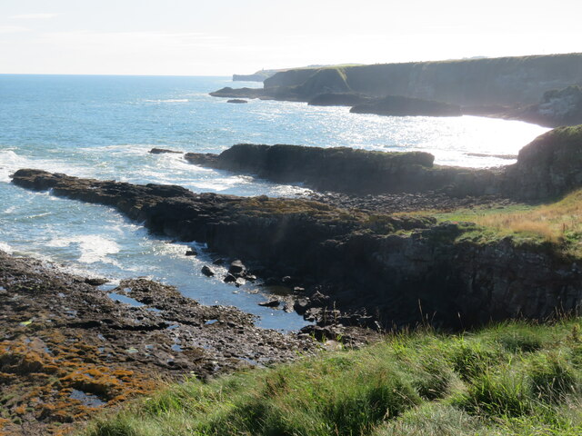
Forley Craig is a small island located off the coast of Kincardineshire, Scotland. It is situated in the North Sea, approximately 3 kilometers from the mainland. The island covers an area of around 0.5 square kilometers and has a rugged and rocky terrain. It is known for its picturesque cliffs that rise steeply from the sea, providing stunning views of the surrounding landscape.

The island is uninhabited and has no permanent structures or facilities. However, it is a popular destination among nature enthusiasts, hikers, and birdwatchers due to its rich biodiversity. Forley Craig is home to a variety of bird species, including puffins, guillemots, razorbills, and kittiwakes, making it an important breeding ground and a designated Site of Special Scientific Interest.

Access to Forley Craig is primarily by boat, and visitors are advised to be cautious due to the treacherous waters and strong currents surrounding the island. There is no designated landing point, and visitors are encouraged to take necessary safety precautions and adhere to environmental guidelines to preserve the island's fragile ecosystem.

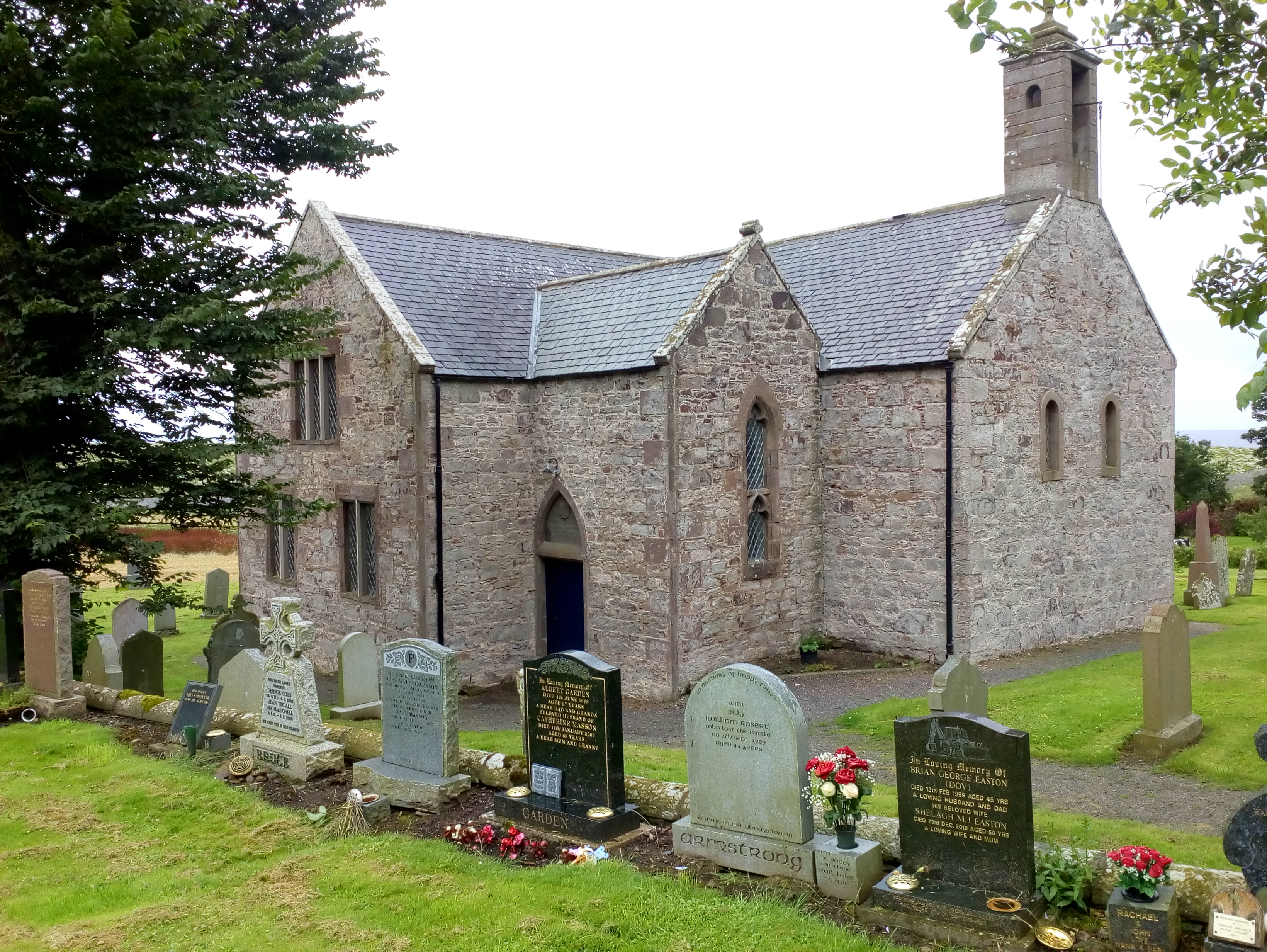
In addition to its natural beauty, Forley Craig also holds historical significance. The remains of an ancient chapel dedicated to St. Adamnan, a 7th-century Irish saint, can be found on the island. These ruins serve as a reminder of the island's past and provide an interesting insight into its historical heritage.

Overall, Forley Craig offers a unique and remote experience for nature lovers and history enthusiasts alike, showcasing the stunning natural beauty and rich history of Kincardineshire.

If you have any feedback on the listing, please let us know in the comments section below.

Forley Craig Images

Images are sourced within 2km of 56.892186/-2.2112403 or Grid Reference NO8777. Thanks to Geograph Open Source API. All images are credited.

S entrance to a through cave at Powdam The tall triangle in line with the kayak bow is the S entrance to a cave which turns right and out on the far side. Only navigable at high tide and very low swell. Powdam is round the corner and left.
S entrance to a through cave at Powdam
The tall triangle in line with the kayak bow is the S entrance to a cave which turns right and out on the far side. Only navigable at high tide and very low swell. Powdam is round the corner and left.
E entrance to a through cave at Powdam Shows the sun shining through the S entrance. See <a href="https://www.geograph.org.uk/photo/6916374">NO8676 : S entrance to a through cave at Powdam</a>. Navigable near high tide with a very low swell. The S tunnel is narrow and the W wall leans E.
E entrance to a through cave at Powdam
Shows the sun shining through the S entrance. See NO8676 : S entrance to a through cave at Powdam. Navigable near high tide with a very low swell. The S tunnel is narrow and the W wall leans E.
Rock ribs extending out into the sea at Crawton The view south from the small headland at Crawton where rocky reefs defy the waves. The view extends along Crawton Bay.
Rock ribs extending out into the sea at Crawton
The view south from the small headland at Crawton where rocky reefs defy the waves. The view extends along Crawton Bay.
Puffin Puffins breed on offshore islands or tall sea cliffs,  outside the breeding season it lives at sea.  They catch small fish such as sand eels, sprat, herring and caplin although it eats many others.
Puffin
Puffins breed on offshore islands or tall sea cliffs, outside the breeding season it lives at sea. They catch small fish such as sand eels, sprat, herring and caplin although it eats many others.
Tod Lighthouse
Tod Lighthouse
Hallhill Farm A farm overlooking the sea by Todhead.
Hallhill Farm
A farm overlooking the sea by Todhead.
Todhead Light. Todhead Lighthouse amid farmland and the North Sea beyond.
Todhead Light.
Todhead Lighthouse amid farmland and the North Sea beyond.
Todhead Lighthouse The lighthouse at Todhead Point.
Todhead Lighthouse
The lighthouse at Todhead Point.
Lambs by Todhead Lambs in a field by Todhead.
Lambs by Todhead
Lambs in a field by Todhead.
Todhead Pasture Sheep grazing by Todhead with Braidon Bay in the background.
Todhead Pasture
Sheep grazing by Todhead with Braidon Bay in the background.
Red soil of the Mearns A tilled field by Kinneff showing the red soil of the Mearns and the blue of the sea in the distance, both portrayed in the literature on local author Lewis Grassic Gibbon.
Red soil of the Mearns
A tilled field by Kinneff showing the red soil of the Mearns and the blue of the sea in the distance, both portrayed in the literature on local author Lewis Grassic Gibbon.
Fernieflatt Farm Lying between Kinneff and Braidon Bay.
Fernieflatt Farm
Lying between Kinneff and Braidon Bay.
By Fernieflatt Fernieflatt Farm by Kinneff.
By Fernieflatt
Fernieflatt Farm by Kinneff.
Glasslin Burn The wooded sides of the Glasslin Burn by Fernieflatt.
Glasslin Burn
The wooded sides of the Glasslin Burn by Fernieflatt.
Daffodil Fields Rows of Daffodils growing by Braidon.
Daffodil Fields
Rows of Daffodils growing by Braidon.
Sheep grazing above Todhead Light Photographer is standing at the verge of the narrow access road.
Sheep grazing above Todhead Light
Photographer is standing at the verge of the narrow access road.
Conglomerate shoreline south of Todhead Point
Approaching the Barras turnoff from the A92 Photographer is above the paved roadway surface looking in the southbound direction along A92.
Approaching the Barras turnoff from the A92
Photographer is above the paved roadway surface looking in the southbound direction along A92.
Show me another place!

Forley Craig is located at Grid Ref: NO8777 (Lat: 56.892186, Lng: -2.2112403)

Unitary Authority: Aberdeenshire

Police Authority: North East

What 3 Words

///event.ivory.viewer. Near Inverbervie, Aberdeenshire

Related Wikis

Catterline

Catterline is a coastal village on the North Sea in Aberdeenshire, Scotland. It is situated about 5 miles (8.0 km) south of Stonehaven; nearby to the...

Crawton

Crawton is a former fishing community on the southeast Aberdeenshire coast in Scotland, deserted since 1927. Approximately three miles south of Stonehaven...

Fowlsheugh

Fowlsheugh is a coastal nature reserve in Kincardineshire, northeast Scotland, known for its 70-metre-high (230 ft) cliff formations and habitat supporting...

Kinneff

Kinneff is a roadside hamlet in Aberdeenshire, Scotland, just north of Inverbervie. To the north lies another hamlet, Catterline. Kinneff also has a primary...

Craiglethy

Craiglethy (Scottish Gaelic: Creag Liathach - meaning grey rock) is a small island/skerry off Fowlsheugh on the east coast of Aberdeenshire, Scotland in...

Thornyhive Bay

Thornyhive Bay is an embayment along the North Sea coast in Aberdeenshire, Scotland. This bay is situated approximately 2.5 miles south of the town of...

Castle of Fiddes

The Castle of Fiddes is a 16th-century tower house in Aberdeenshire, Scotland, located around 6 kilometres (3.7 mi) south-west of Stonehaven. It is dated...

Dunnottar Castle

Dunnottar Castle (Scottish Gaelic: Dùn Fhoithear, "fort on the shelving slope") is a ruined medieval fortress located upon a rocky headland on the north...

Nearby Amenities

Located within 500m of 56.892186,-2.2112403
Source: PGS
Lat/Long: 56.8915047/-2.2110901
Source: PGS
Lat/Long: 56.891857/-2.2117346
Source: PGS
Lat/Long: 56.8926448/-2.211791
Source: PGS
Lat/Long: 56.8930538/-2.2118124
Source: PGS
Lat/Long: 56.8929277/-2.2112792
Source: PGS
Lat/Long: 56.8927819/-2.2109538
Created By: almien_coastlines
Source: PGS
Lat/Long: 56.892749/-2.210733
Source: PGS
Lat/Long: 56.8922986/-2.2106186
Source: PGS
Lat/Long: 56.892087/-2.2108326
Created By: almien_coastlines
Source: PGS
Lat/Long: 56.88868/-2.215029
Source: PGS
Lat/Long: 56.8892357/-2.2156189
Source: PGS
Lat/Long: 56.8890423/-2.2151077
Created By: almien_coastlines
Source: PGS
Lat/Long: 56.889699/-2.214305
Source: PGS
Lat/Long: 56.8899387/-2.2140139
Created By: almien_coastlines
Source: PGS
Lat/Long: 56.889181/-2.213381
Created By: almien_coastlines
Source: PGS
Lat/Long: 56.889951/-2.213599
Created By: almien_coastlines
Source: PGS
Lat/Long: 56.890466/-2.214056
Source: PGS
Lat/Long: 56.8912441/-2.2141963
Source: PGS
Lat/Long: 56.890867/-2.2139704
Created By: almien_coastlines
Source: PGS
Lat/Long: 56.891357/-2.213335
Source: PGS
Lat/Long: 56.8916751/-2.2135069
Source: PGS
Lat/Long: 56.8920449/-2.2134318
Source: PGS
Lat/Long: 56.8924221/-2.2128102
Created By: almien_coastlines
Source: PGS
Lat/Long: 56.892764/-2.213072
Source: PGS
Lat/Long: 56.8929836/-2.2132466
Source: PGS
Lat/Long: 56.8928426/-2.2145909
Source: PGS
Lat/Long: 56.8935067/-2.2161496
Source: PGS
Lat/Long: 56.8938006/-2.216368
Source: PGS
Lat/Long: 56.8940149/-2.21643
Source: PGS
Lat/Long: 56.8945888/-2.2163589
Source: PGS
Lat/Long: 56.895/-2.2160781
Source: PGS
Lat/Long: 56.8952572/-2.2156056
Source: PGS
Lat/Long: 56.8953732/-2.2151724
Source: PGS
Lat/Long: 56.8951262/-2.2142594
Source: PGS
Lat/Long: 56.8950858/-2.2136658
Source: PGS
Lat/Long: 56.894985/-2.2130138
Source: PGS
Lat/Long: 56.8949634/-2.2127219
Source: PGS
Lat/Long: 56.8951296/-2.2125192
Source: PGS
Lat/Long: 56.895373/-2.2125728
Source: PGS
Lat/Long: 56.8957057/-2.2132516
Source: PGS
Lat/Long: 56.8960534/-2.2126728
Source: PGS
Lat/Long: 56.8961665/-2.212014
Source: PGS
Lat/Long: 56.8964217/-2.2113531
Source: PGS
Lat/Long: 56.8964739/-2.2098615
Created By: almien_coastlines
Source: PGS
Lat/Long: 56.896584/-2.209717
Forley Craig
Place: locality
Lat/Long: 56.8924615/-2.2117076
Catterline Bay
Natural: bay
Lat/Long: 56.8942266/-2.2143012
Reath
Natural: bay
Lat/Long: 56.8893511/-2.2144967
The data included in this document is from www.openstreetmap.org. The data is made available under ODbL.

Have you been to Forley Craig?

Leave your review of Forley Craig below (or comments, questions and feedback).