Fairtide Rock

Island in Gloucestershire Forest of Dean

England

Fairtide Rock

Lydney Harbour The lock at the entrance to Lydney Harbour from the river Severn.
Lydney Harbour Credit: David Stowell

Fairtide Rock is a small island located in the county of Gloucestershire, England. Situated in the River Severn, the island is known for its unique characteristics and historical significance.

Measuring approximately 3 acres in size, Fairtide Rock is a rocky outcrop that emerges above the water during low tide and becomes partially submerged during high tide. This natural phenomenon has made the island a popular attraction for visitors who can witness its transformation throughout the day. The island's rocky terrain is covered in vegetation, including grasses, shrubs, and small trees, creating a picturesque landscape.

Historically, Fairtide Rock has played a significant role in the region. It is believed to have served as a defensive position during medieval times, with remnants of fortifications and defensive walls still visible today. The island's strategic location in the River Severn made it an ideal spot for guarding against potential invaders.

Access to Fairtide Rock is limited due to its location in the river. During low tide, it is possible to reach the island by foot, but caution is advised as the rocky path can be slippery. Boat trips are also available for those who wish to explore the island from the water.

In addition to its historical importance, Fairtide Rock provides a habitat for various bird species, attracting birdwatchers and nature enthusiasts. The island's unique ecosystem and natural beauty make it a fascinating destination for anyone interested in history, geology, and the natural world.

If you have any feedback on the listing, please let us know in the comments section below.

Fairtide Rock Images

Images are sourced within 2km of 51.716413/-2.5013759 or Grid Reference SO6502. Thanks to Geograph Open Source API. All images are credited.

Lydney Harbour The lock at the entrance to Lydney Harbour from the river Severn.
Lydney Harbour
The lock at the entrance to Lydney Harbour from the river Severn.
Canal Gates at Lydney Harbour The canal has not been used for many years but the gates are in good condition.
Canal Gates at Lydney Harbour
The canal has not been used for many years but the gates are in good condition.
Canal lock gates  Lydney This view also shows the outline of Berkeley Nuclear Power Station. {now decommissioned.}
Canal lock gates Lydney
This view also shows the outline of Berkeley Nuclear Power Station. {now decommissioned.}
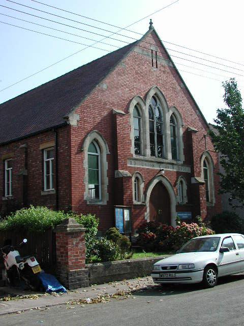
Sharpness (Glos) United Reformed Church This area of the town is known as Newtown and this was built in 1902 as the Union Chapel
Sharpness (Glos) United Reformed Church
This area of the town is known as Newtown and this was built in 1902 as the Union Chapel
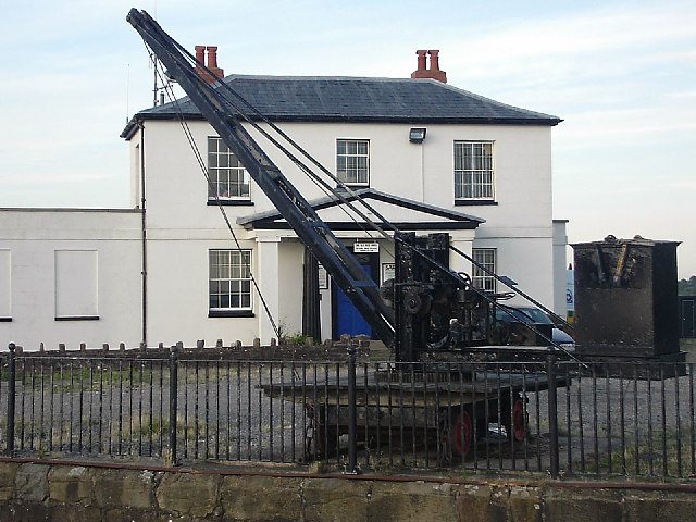
Dock Master's house, Sharpness Old Dock This grade two listed building is now the Severn Area Rescue Association's Sharpness station. The station houses three of SARA's inshore rescue boats and a land search / boat haulage vehicle. The crane is used to launch SARA's rescue boats.
Dock Master's house, Sharpness Old Dock
This grade two listed building is now the Severn Area Rescue Association's Sharpness station. The station houses three of SARA's inshore rescue boats and a land search / boat haulage vehicle. The crane is used to launch SARA's rescue boats.
Entrance to Sharpness Old Dock The Old Dock is no longer used, having been replaced by the New Dock which was built in 1870.
Entrance to Sharpness Old Dock
The Old Dock is no longer used, having been replaced by the New Dock which was built in 1870.
Severn Estuary at Sharpness Old Dock The tide was rising rapidly when this photograph was taken. The Severn estuary has a tidal range of 15 metres, the second largest in the world.
Severn Estuary at Sharpness Old Dock
The tide was rising rapidly when this photograph was taken. The Severn estuary has a tidal range of 15 metres, the second largest in the world.
Severn Way Looking south from the houses by the picnic area at the extreme top right corner of the grid square (Severn Road). The Severn Way stretches southwards towards Berkeley Nuclear Power Station (de-commissioned), visible as two large square outlines beside the river. The path is on top of a flood-defence bank - the River Severn has the second greatest tidal flow in the world.
Severn Way
Looking south from the houses by the picnic area at the extreme top right corner of the grid square (Severn Road). The Severn Way stretches southwards towards Berkeley Nuclear Power Station (de-commissioned), visible as two large square outlines beside the river. The path is on top of a flood-defence bank - the River Severn has the second greatest tidal flow in the world.
Sharpness Dock Lock Looking east into the lock at the entrance to Sharpness Docks at low tide. The lock base is a sea of mud, traversed by a rivulet of water flowing through the inner lock gate to the actual docks behind <a href="https://www.geograph.org.uk/gridref/SO6702">SO6702</a>. This is the 'new' entrance to the Gloucester & Sharpness canal, today mainly used for leisure activities.
Sharpness Dock Lock
Looking east into the lock at the entrance to Sharpness Docks at low tide. The lock base is a sea of mud, traversed by a rivulet of water flowing through the inner lock gate to the actual docks behind SO6702. This is the 'new' entrance to the Gloucester & Sharpness canal, today mainly used for leisure activities.
Saniger Farm House The southern half of this square is farmland, part of the extensive Berkeley estate. The tablet above the front door records that this farmhouse was built by 'E.S.' in 1718.
Saniger Farm House
The southern half of this square is farmland, part of the extensive Berkeley estate. The tablet above the front door records that this farmhouse was built by 'E.S.' in 1718.
Naas Court nr Lydney I always thought it would be more impressive.
Naas Court nr Lydney
I always thought it would be more impressive.
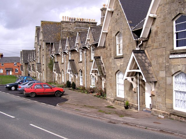
Cookson Terrace, Lydney Built by the Severn & Wye Railway Co and named after the chairman Joseph Cookson.
Cookson Terrace, Lydney
Built by the Severn & Wye Railway Co and named after the chairman Joseph Cookson.
Crump Farm Down a lane out of Lydney.
Crump Farm
Down a lane out of Lydney.
Severnbanks Primary School, Lydney
Gloucester to Chepstow Railway Line Picture showing the rich, fertile farmland of the Severn Vale. Almost half of this grid is the River Severn.
Gloucester to Chepstow Railway Line
Picture showing the rich, fertile farmland of the Severn Vale. Almost half of this grid is the River Severn.
River Severn Picture looking across the River Severn towards Sharpness Docks, with the Cotswolds away in the distance.
River Severn
Picture looking across the River Severn towards Sharpness Docks, with the Cotswolds away in the distance.
Course of the old Railway Though it's difficult to see, a railway line used to run across the middle of this photograph. It used to run over the old Severn Railway bridge which linked Lydney to Sharpness.
Course of the old Railway
Though it's difficult to see, a railway line used to run across the middle of this photograph. It used to run over the old Severn Railway bridge which linked Lydney to Sharpness.
Nonchalant Fox This footpath is only recently made, Autumn 2006. The old path used to head through the woods, whilst the new one offers panoramic views of the Severn. In the centre of the photo is a fox that seemed quite unconcerned at me turning up.
Nonchalant Fox
This footpath is only recently made, Autumn 2006. The old path used to head through the woods, whilst the new one offers panoramic views of the Severn. In the centre of the photo is a fox that seemed quite unconcerned at me turning up.
Show me another place!

Fairtide Rock is located at Grid Ref: SO6502 (Lat: 51.716413, Lng: -2.5013759)

Administrative County: Gloucestershire

District: Forest of Dean

Police Authority: Gloucestershire

What 3 Words

///cooks.blink.partly. Near Sharpness, Gloucestershire

Nearby Locations

Naas Cliff Fairtide Rock

Related Wikis

Lydney Cliff

Lydney Cliff (grid reference SO654020) is a 8.0-hectare (20-acre) geological Site of Special Scientific Interest in Gloucestershire, notified in 1990....

Lydney Rural District

Lydney was a rural district in Gloucestershire, England from 1894 to 1974. It covered an area on the Welsh border by the Severn estuary. It was formed...

Sharpness

Sharpness ( sharp-NESS) is an English port in Gloucestershire, one of the most inland in Britain, and eighth largest in the South West England region....

Lydney Town A.F.C.

Lydney Town A.F.C. are a football club based in Lydney, Gloucestershire, England. They are currently member of the Hellenic League Premier Division. The...

Nearby Amenities

Located within 500m of 51.716413,-2.5013759
Source: PGS
Lat/Long: 51.7124213/-2.5044717
Source: PGS
Lat/Long: 51.7128325/-2.5041575
Source: PGS
Lat/Long: 51.7130755/-2.503887
Source: PGS
Lat/Long: 51.7136683/-2.5033847
Source: PGS
Lat/Long: 51.7144762/-2.5024763
Source: PGS
Lat/Long: 51.7150311/-2.5020172
Source: PGS
Lat/Long: 51.7160194/-2.5014253
Source: PGS
Lat/Long: 51.7169823/-2.5012924
Source: PGS
Lat/Long: 51.7174283/-2.5011194
Source: PGS
Lat/Long: 51.7184254/-2.5005029
Source: PGS
Lat/Long: 51.7187954/-2.500292
Source: PGS
Lat/Long: 51.71932/-2.499905
Source: PGS
Lat/Long: 51.720343/-2.499481
The data included in this document is from www.openstreetmap.org. The data is made available under ODbL.

Have you been to Fairtide Rock?

Leave your review of Fairtide Rock below (or comments, questions and feedback).