Black Rock

Island in Somerset

England

Black Rock

Brean Down steps Approaching Brean Down from the car park below
Brean Down steps Credit: Jonathan Dew

Black Rock is a small island located off the coast of Somerset in South West England. It lies in the Bristol Channel, approximately 3 miles west of the town of Weston-super-Mare. The island, measuring around 500 meters in length and 200 meters in width, is privately owned and uninhabited, with no permanent structures or amenities.

Black Rock is primarily composed of limestone, with a rugged coastline consisting of cliffs and small rocky coves. The island is known for its rich biodiversity and is designated as a Site of Special Scientific Interest (SSSI) due to its unique flora and fauna. It is home to a variety of bird species, including gulls, cormorants, and shags, making it a popular spot for birdwatchers.

Access to Black Rock is limited and can be challenging due to the strong currents and tides in the Bristol Channel. However, during low tide, it is possible to walk across the causeway from the mainland to the island. Visitors are advised to check the tide times and take necessary precautions when planning a visit.

Despite its relatively small size and lack of infrastructure, Black Rock attracts visitors who appreciate its untouched natural beauty and tranquility. It offers opportunities for coastal walks, wildlife observation, and photography. The island's isolation and unspoiled environment make it a haven for those seeking a peaceful escape.

If you have any feedback on the listing, please let us know in the comments section below.

Black Rock Images

Images are sourced within 2km of 51.323904/-2.9965324 or Grid Reference ST3058. Thanks to Geograph Open Source API. All images are credited.

Brean Down steps Approaching Brean Down from the car park below
Brean Down steps
Approaching Brean Down from the car park below
Sand yachts on Brean Sands
Brean Down Tropical Bird Garden Looking down on the Bird Garden from the Brean headland.
Brean Down Tropical Bird Garden
Looking down on the Bird Garden from the Brean headland.
A path with a view Brean Down is the promontory on the south of Weston Bay. Walks along it give wonderful views along the coast. Here, the flat mud of low tide can be seen in front of the promenade of Weston-super-Mare.
A path with a view
Brean Down is the promontory on the south of Weston Bay. Walks along it give wonderful views along the coast. Here, the flat mud of low tide can be seen in front of the promenade of Weston-super-Mare.
Brean Down car park Park here and start a wounderful circular walk around Brean Down.
Brean Down car park
Park here and start a wounderful circular walk around Brean Down.
View of Brean Down A view of the far end of the beach at Brean Down.
View of Brean Down
A view of the far end of the beach at Brean Down.
Master of the slopes One of the herd of about two dozen goats inhabiting the cliffs.
Master of the slopes
One of the herd of about two dozen goats inhabiting the cliffs.
Beach at Brean A peaceful view of the beach at Brean and on to Berrow from Brean Down.
Beach at Brean
A peaceful view of the beach at Brean and on to Berrow from Brean Down.
Caravans at Brean Holiday caravans on a quiet October day
Caravans at Brean
Holiday caravans on a quiet October day
Windswept trees Windswept trees on Brean down with Weston-Super-Mare in the background.
Windswept trees
Windswept trees on Brean down with Weston-Super-Mare in the background.
Tortured trees Trees showing the effect of the harsh environment.
Tortured trees
Trees showing the effect of the harsh environment.
A cow on Brean Down Quite a slope for this cow to rest on!  One of a small herd.
A cow on Brean Down
Quite a slope for this cow to rest on! One of a small herd.
Tidal rubbish at Brean Down View north-west from near the car park to Brean Down. The funnel-shaped Bristol Channel creates the second-highest tidal range in the world, which is why Brean-to-Lavernock across the estuary is a prime potential site for a tidal energy barrage. It also tends to collect and leave a lot of marine rubbish behind at the high-tide mark.
Tidal rubbish at Brean Down
View north-west from near the car park to Brean Down. The funnel-shaped Bristol Channel creates the second-highest tidal range in the world, which is why Brean-to-Lavernock across the estuary is a prime potential site for a tidal energy barrage. It also tends to collect and leave a lot of marine rubbish behind at the high-tide mark.
Footpath along the crest of Brean Down Looking eastwards towards Uphill and Oldmixon villages on the side of Bleadon Hill. Brean beach to the right.
Footpath along the crest of Brean Down
Looking eastwards towards Uphill and Oldmixon villages on the side of Bleadon Hill. Brean beach to the right.
Berrow Flats Berrow Flats looking south from Brean Down
Berrow Flats
Berrow Flats looking south from Brean Down
Weston Bay World War II machine gun post on Brean Down, looking across Weston Bay towards Weston super Mare.
Weston Bay
World War II machine gun post on Brean Down, looking across Weston Bay towards Weston super Mare.
Bluebells on North side of Brean Down Steep Holm in the distance.
Bluebells on North side of Brean Down
Steep Holm in the distance.
White Rock Rose on south facing slope by top of steps. Although a very steep slope the White Rock Roses are easily viewed from the steps leading up to the Down.
White Rock Rose on south facing slope by top of steps.
Although a very steep slope the White Rock Roses are easily viewed from the steps leading up to the Down.
Show me another place!

Black Rock is located at Grid Ref: ST3058 (Lat: 51.323904, Lng: -2.9965324)

Unitary Authority: North Somerset

Police Authority: Avon and Somerset

What 3 Words

///slices.words.stays. Near Weston-super-Mare, Somerset

Nearby Locations

Black Rock

Related Wikis

River Axe (Bristol Channel)

The River Axe is a river in South West England. The river is formed by water entering swallets in the limestone and rises from the ground at Wookey Hole...

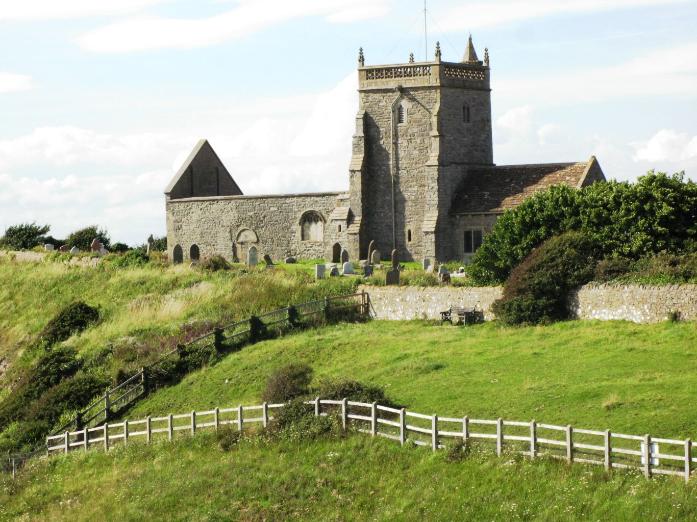
Old Church of St Nicholas, Uphill

The Old Church of St Nicholas at Uphill, Somerset, England, is described as 'Norman' but was remodelled in later Middle Ages. Regular services ceased in...

Weston Bay

Weston Bay is an inlet of the Bristol Channel in North Somerset, England. It lies between Brean Down, which is now owned by the National Trust, is rich...

Uphill Cliff

Uphill Cliff (grid reference ST318583) is a 19.8 hectare biological Site of Special Scientific Interest near the village of Uphill, North Somerset, although...

Nearby Amenities

Located within 500m of 51.323904,-2.9965324
Source: PGS
Lat/Long: 51.3250197/-2.9900882
The data included in this document is from www.openstreetmap.org. The data is made available under ODbL.

Have you been to Black Rock?

Leave your review of Black Rock below (or comments, questions and feedback).