Tortoiseshell Rocks

Island in Devon

England

Tortoiseshell Rocks

Sandy Cove The outcrop on the right has a deposit of guano, where seagulls often perch
Sandy Cove Credit: David Smith

Tortoiseshell Rocks is a picturesque island located off the coast of Devon, in the southwestern part of England. Situated in the English Channel, this small rocky outcrop boasts stunning natural beauty and is a popular destination for nature enthusiasts and outdoor adventurers.

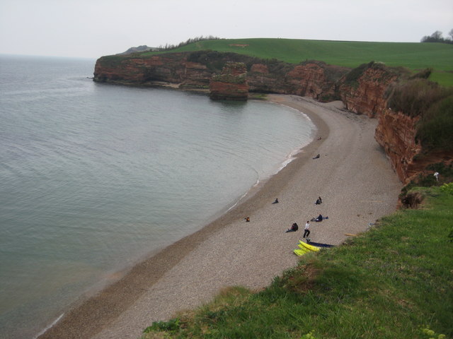
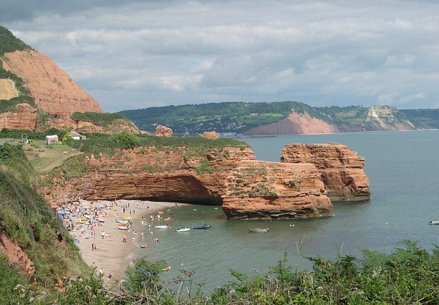
The island, named after the distinctive tortoiseshell pattern found on the rocks, is characterized by its rugged coastline and jagged cliffs that provide breathtaking views of the surrounding sea. With its diverse range of flora and fauna, including rare bird species and marine life, Tortoiseshell Rocks is a designated nature reserve, attracting birdwatchers and wildlife enthusiasts from all over.

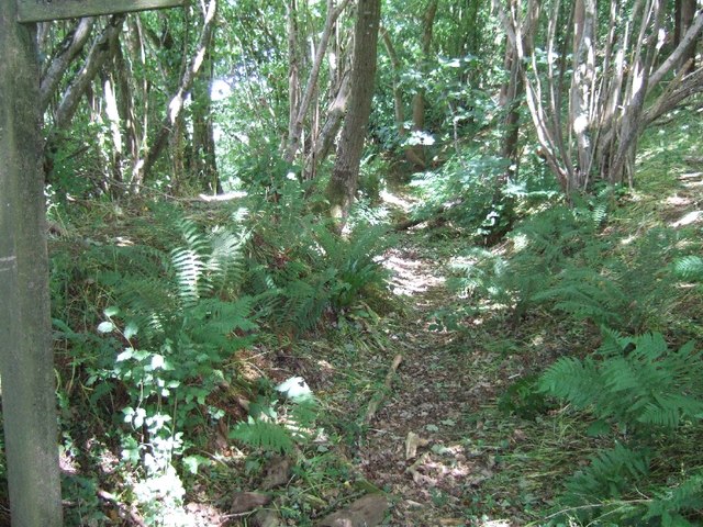
Access to the island is limited, as it can only be reached by boat or during low tide when a causeway connects it to the mainland. This adds to its allure and ensures that its natural habitats are preserved and protected. Visitors can explore the island by foot, following a network of well-maintained trails that wind through its diverse landscapes, including heathland, rocky shores, and grassy meadows.

Additionally, Tortoiseshell Rocks is known for its rich history, with evidence of human occupation dating back to prehistoric times. Archaeological excavations have revealed ancient burial sites and artifacts, shedding light on the island's past. Today, visitors can learn about this history through informative displays at the island's visitor center.

Overall, Tortoiseshell Rocks offers a unique and enchanting experience for those seeking to immerse themselves in the natural beauty and rich heritage of Devon's coastline.

If you have any feedback on the listing, please let us know in the comments section below.

Tortoiseshell Rocks Images

Images are sourced within 2km of 50.670331/-3.262439 or Grid Reference SY1086. Thanks to Geograph Open Source API. All images are credited.

Sandy Cove The outcrop on the right has a deposit of guano, where seagulls often perch
Sandy Cove
The outcrop on the right has a deposit of guano, where seagulls often perch
Sandy Cove and High Peak
Ladram Bay
Ladram Bay
Delivering a playground ship The play area at Ladram Bay Holiday Park was being extended with this playground ship.
Delivering a playground ship
The play area at Ladram Bay Holiday Park was being extended with this playground ship.
Ladram Bay Holiday Park; permanent buildings
Smallstones Point
Smallstones Point
Stack in Ladram Bay
Stack in Ladram Bay
Landram Road The section of Landram Road from Sea View Farm towards the coast may once have been a road, although no more than 6 feet wide, but is now no more than a footpath.
Landram Road
The section of Landram Road from Sea View Farm towards the coast may once have been a road, although no more than 6 feet wide, but is now no more than a footpath.
Ottery Street leading south from Pinn Lane Corner
Ottery Street, part of NCN2
Passaford Lane This public footpath in a hollow-way leads to Pinn Beacon
Passaford Lane
This public footpath in a hollow-way leads to Pinn Beacon
The edge of Pinn Beacon Plantation The woods touch farmland here.  The boundary is a bank with a hedge, and there is a sunken path just inside the woodland.
The edge of Pinn Beacon Plantation
The woods touch farmland here. The boundary is a bank with a hedge, and there is a sunken path just inside the woodland.
Ladram Bay Holiday Park High Peak can be seen in the background.
Ladram Bay Holiday Park
High Peak can be seen in the background.
Lodges at Ladram Bay Lodges at Ladram Bay Holiday Park, viewed from the South West Coast Path which passes through the park.
Lodges at Ladram Bay
Lodges at Ladram Bay Holiday Park, viewed from the South West Coast Path which passes through the park.
Thatched cottage above Ladram Bay Thatched cottage above Ladram Bay on Ladram Bay Holiday Park.
Thatched cottage above Ladram Bay
Thatched cottage above Ladram Bay on Ladram Bay Holiday Park.
Ladram Rock and Ladram Bay
Ladram Bay View across Ladram Bay from the coast path.
Ladram Bay
View across Ladram Bay from the coast path.
Hern Point Rock Hern Point Rock and High Peak near Ladram Bay.
Hern Point Rock
Hern Point Rock and High Peak near Ladram Bay.
Show me another place!

Tortoiseshell Rocks is located at Grid Ref: SY1086 (Lat: 50.670331, Lng: -3.262439)

Administrative County: Devon

Police Authority: Devon and Cornwall

What 3 Words

///fallen.good.known. Near Sidmouth, Devon

Related Wikis

Peak House, Sidmouth

Peak House in Sidmouth, Devon, is a building designed by Evelyn Hellicar. It was finished in 1904 and is entirely made of beer stone. It is a Grade II...

High Peak, Devon

High Peak (also known as Peak Hill) is a hill which is partially eroded, resulting in a cliff face, on the English Channel coast to the southwest of Sidmouth...

Ladram Bay

Ladram Bay is a secluded bay with a pebble beach, on the south coast of Devon, England between the coastal towns of Budleigh Salterton and Sidmouth. It...

Kennaway House

Kennaway House is a Regency town house in Sidmouth, East Devon, which was formerly known as Fort House and Church House. It is a Grade II* listed building...

Nearby Amenities

Located within 500m of 50.670331,-3.262439
Source: PGS
Lat/Long: 50.6669396/-3.2657926
Source: PGS
Lat/Long: 50.6683262/-3.2662347
Source: PGS
Lat/Long: 50.669074/-3.2658356
Source: PGS
Lat/Long: 50.6693738/-3.2655631
Source: PGS
Lat/Long: 50.6696627/-3.2652832
Source: PGS
Lat/Long: 50.6699866/-3.2642926
Source: PGS
Lat/Long: 50.6700417/-3.2640997
Source: PGS
Lat/Long: 50.6701229/-3.26394
Source: PGS
Lat/Long: 50.6703275/-3.2633807
Source: PGS
Lat/Long: 50.6712992/-3.2611076
Source: PGS
Lat/Long: 50.6719874/-3.2591244
Barrier: kissing_gate
Lat/Long: 50.6719086/-3.2658643
Barrier: kissing_gate
Lat/Long: 50.6703605/-3.2682861
Tortoiseshell Rocks
Natural: rocks
Lat/Long: 50.6702054/-3.2620446
Direction: 180
Tourism: viewpoint
Lat/Long: 50.6740945/-3.2598436
Bench
Backrest: no
Lat/Long: 50.6691689/-3.2688168
Tourism: viewpoint
Lat/Long: 50.6692322/-3.2688267
Barrier: kissing_gate
Lat/Long: 50.6740852/-3.260508
Barrier: kissing_gate
Lat/Long: 50.6693709/-3.2689662
Bench
Backrest: no
Survey Date: 2023-03-18
Lat/Long: 50.6741259/-3.2598638
The data included in this document is from www.openstreetmap.org. The data is made available under ODbL.

Have you been to Tortoiseshell Rocks?

Leave your review of Tortoiseshell Rocks below (or comments, questions and feedback).