Carreg Penrhyn-glas

Island in Pembrokeshire

Wales

Carreg Penrhyn-glas

Dinas Head Seen from the road from Fishguard to Newport
Dinas Head Credit: Deborah Tilley

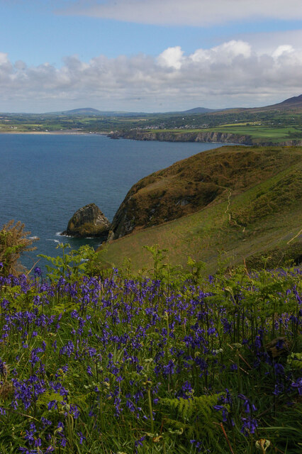
Carreg Penrhyn-glas is a small uninhabited island located off the coast of Pembrokeshire, Wales. It is situated in St Bride's Bay, approximately 1.5 kilometers from the mainland. The island covers an area of around 1.5 hectares and has a maximum elevation of 24 meters.

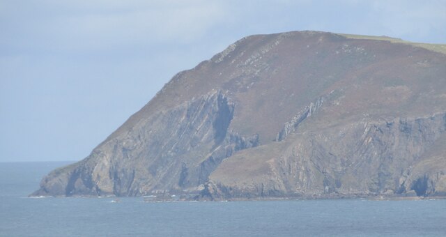
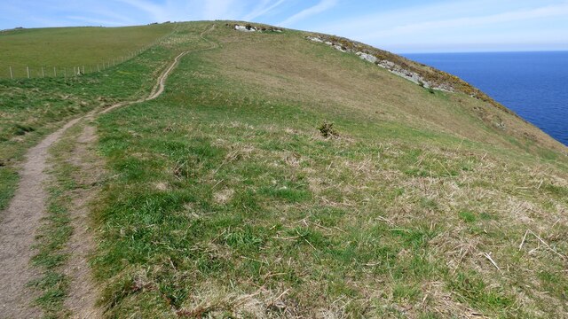
The island is characterized by its rugged and rocky terrain, with a jagged coastline that features numerous sea cliffs and small coves. It is primarily composed of hard volcanic rock, giving it a distinctive appearance. The vegetation on Carreg Penrhyn-glas is limited, consisting mainly of low-growing grasses and some hardy shrubs.

Due to its remote location and challenging access, Carreg Penrhyn-glas is rarely visited by humans. However, it is a popular spot for seabirds, with several species using the island for nesting and roosting. Visitors may spot colonies of guillemots, razorbills, and kittiwakes, among others.

The island can be reached by boat, but caution is advised due to the strong currents and potentially rough seas in the area. It is also important to note that there are no amenities or facilities on Carreg Penrhyn-glas, making it necessary for visitors to bring their own supplies and take any waste with them when leaving.

Carreg Penrhyn-glas offers a unique opportunity for nature enthusiasts and birdwatchers to explore a secluded and untouched landscape. Its untamed beauty and abundant wildlife make it a captivating destination for those seeking a remote and unspoiled natural environment.

If you have any feedback on the listing, please let us know in the comments section below.

Carreg Penrhyn-glas Images

Images are sourced within 2km of 52.023609/-4.8887562 or Grid Reference SN0140. Thanks to Geograph Open Source API. All images are credited.

Dinas Head Seen from the road from Fishguard to Newport
Dinas Head
Seen from the road from Fishguard to Newport
Inaccessible cove Tiny bay visitable only by boat: note the float and line left to mark the spot a lobster pot has been dropped.
Inaccessible cove
Tiny bay visitable only by boat: note the float and line left to mark the spot a lobster pot has been dropped.
Gull's egg The egg has been broken into and the torn shell left lying in the grass. Another bird is most likely to have been the culprit.
Gull's egg
The egg has been broken into and the torn shell left lying in the grass. Another bird is most likely to have been the culprit.
Sea wall, Cwm-yr-Eglwys: Dinas
View east along the Pembrokeshire Coast Path on Dinas Island
Dinas Head The rugged promontory of Dinas Head (142m amsl) - seen here from Saddle Point above Fishguard Harbour.
Dinas Head
The rugged promontory of Dinas Head (142m amsl) - seen here from Saddle Point above Fishguard Harbour.
Cliffs at Pen Castell
Pembrokeshire Coast Path leading up Pen y Fan
St Brynach's Church
St Brynach's Church
Pwll Glas on Dinas Island
View of the coast from near Pen Castell
Coast path heading north
Church of St Brynach remains At Cwm-yr-Eglwys
Church of St Brynach remains
At Cwm-yr-Eglwys
Cwm-yr-Eglwys Beach View from the sea wall round to Pig y Baw
Cwm-yr-Eglwys Beach
View from the sea wall round to Pig y Baw
Cwm-yr-Eglwys Beach View to Trywn Isaac with more of the sea defences on the far right
Cwm-yr-Eglwys Beach
View to Trywn Isaac with more of the sea defences on the far right
Remains of St Brynach's church
Trig Point on Pen y Fan, Dinas Head
Churchyard and ruined church, Cwm yr Eglwys All that remains of the church of St Brynach, the rest having been washed away by the so-called Royal Charter Storm of October 1859.   A somewhat melancholy sight, all the more so on a drizzly afternoon. 

As for the meaning of the name, if this were Cornwall rather than West Wales, the wording on the map might well be 'Church Cove'.
Churchyard and ruined church, Cwm yr Eglwys
All that remains of the church of St Brynach, the rest having been washed away by the so-called Royal Charter Storm of October 1859. A somewhat melancholy sight, all the more so on a drizzly afternoon. As for the meaning of the name, if this were Cornwall rather than West Wales, the wording on the map might well be 'Church Cove'.
Show me another place!

Carreg Penrhyn-glas is located at Grid Ref: SN0140 (Lat: 52.023609, Lng: -4.8887562)

Unitary Authority: Pembrokeshire

Police Authority: Dyfed Powys

What 3 Words

///liner.fury.bleaching. Near Newport, Pembrokeshire

Related Wikis

Cwm-yr-Eglwys

Cwm-yr-Eglwys (English: Valley of the Church) is a hamlet in a picturesque cove on the eastern side of the Dinas Island peninsula in the community of Dinas...

Brynhenllan

Bryn-henllan, Bryn Henllan or Brynhenllan is a small settlement in the community of Dinas Cross, north Pembrokeshire, Wales, just north of the A487 road...

Dinas Island

Dinas Island (Welsh: Ynys Dinas) is a peninsula, partially detached from the mainland, in the community of Dinas Cross between Fishguard and Newport, Pembrokeshire...

Cwm Dewi

Cwm Dewi is a Site of Special Scientific Interest (or SSSI) in Pembrokeshire, South Wales. It has been designated as a Site of Special Scientific Interest...

Pwllgwaelod

Pwllgwaelod (originally Y Pwll Gwaelod, Welsh for The Bottom Cove/Creek) is a small scattered hamlet centred on a bay on the south-western side of the...

Newport Bay (Wales)

Newport Bay (Welsh: Bae Trefdraeth) is a bay on a section of the north Pembrokeshire coast, Wales, which is within the Pembrokeshire Coast National Park...

Dinas Cross

Dinas Cross (Welsh: Dinas) is both a village, a community and a former parish in Pembrokeshire, Wales. Located between Fishguard and Newport in the Pembrokeshire...

River Nevern

The River Nevern (Welsh: Afon Nyfer) is a river in Pembrokeshire, Wales. Its source is north of the village of Crymych and its length is about 11 miles...

Nearby Amenities

Located within 500m of 52.023609,-4.8887562
Cwm-yr-Eglwys
Created By: Potlatch 0.9b
Is In: Pembrokeshire
Place: hamlet
Wikidata: Q5197179
Lat/Long: 52.023018/-4.8955484
Toilets
Source: survey
Lat/Long: 52.0236264/-4.895611
Post Box
Collection Times: Mo-Fr 09:15; Sa 09:15
Operator: Royal Mail
Post Box Type: wall
Ref: SA42 66
Royal Cypher: VR
Source: survey
Survey Date: 2023-06-19
Lat/Long: 52.0229675/-4.8947189
Bench
Lat/Long: 52.0238113/-4.8949582
Bench
Lat/Long: 52.0237606/-4.8948414
Bench
Lat/Long: 52.0236914/-4.8947937
Bench
Lat/Long: 52.0236212/-4.8947413
Give Way
Direction: forward
Lat/Long: 52.0230908/-4.8953769
Aber Gwyn
Natural: bay
Lat/Long: 52.0237057/-4.8918721
Saint Brynach's Belfry
Historic: archaeological_site
Lat/Long: 52.0234984/-4.8946682
Leisure: slipway
Lat/Long: 52.0233783/-4.8945234
Bench
Lat/Long: 52.0234508/-4.8946232
The data included in this document is from www.openstreetmap.org. The data is made available under ODbL.

Have you been to Carreg Penrhyn-glas?

Leave your review of Carreg Penrhyn-glas below (or comments, questions and feedback).