Eilean na h-Eaglaise

Island in Argyllshire

Scotland

Eilean na h-Eaglaise

Cuan Sound Cuan Sound is the stretch of water between the isles of Seil and Luing. It takes its name from Cuan on the southern tip of Seil from where a small car ferry operates to and from Cnoc na h-Earde on Luing. As can be seen the sound is spanned by an HT power line with a pylon on each of the islands, this provides mains electricity to the isle of Luing. At its narrowest the sound is about 200m (660') wide and a minimum depth of about 54' (16.5m). There can be a strong tidal race through the sound, though it looks very peaceful in this image.
Cuan Sound Credit: Rob Farrow

Eilean na h-Eaglaise, also known as the Church Island, is a small island located in Argyllshire, Scotland. Situated in Loch Awe, it is approximately 1.5 miles southwest of the village of Lochawe. The island has a rich historical and cultural significance.

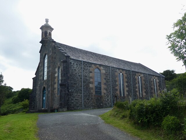
The island gets its name from the ruined church that stands on its grounds, dating back to the 12th century. The church is dedicated to St. Conan, a local saint, and its remains provide a glimpse into the past. The island is accessible by boat and visitors can explore the church ruins, which include remnants of the nave, chancel, and a burial ground with ancient gravestones.

Eilean na h-Eaglaise offers stunning views of Loch Awe and the surrounding landscape, making it a popular spot for photographers and nature enthusiasts. The island is covered in lush greenery, with trees and shrubs providing a habitat for various bird species.

The tranquil atmosphere of the island makes it a peaceful retreat for those seeking solace and relaxation. Fishing is also a popular activity, with the waters surrounding the island being home to several species of fish.

While there is no permanent population on Eilean na h-Eaglaise, it remains an important historical site and a significant part of the local heritage. It attracts visitors from near and far, who come to appreciate its natural beauty and explore its historical relics.

If you have any feedback on the listing, please let us know in the comments section below.

Eilean na h-Eaglaise Images

Images are sourced within 2km of 56.264651/-5.610821 or Grid Reference NM7613. Thanks to Geograph Open Source API. All images are credited.
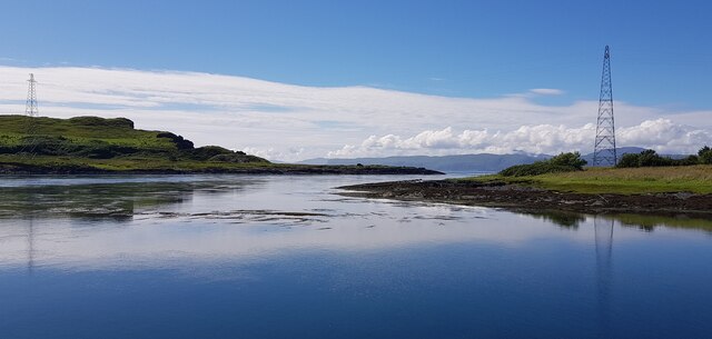
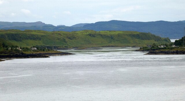
Cuan Sound Cuan Sound is the stretch of water between the isles of Seil and Luing. It takes its name from Cuan on the southern tip of Seil from where a small car ferry operates to and from Cnoc na h-Earde on Luing. As can be seen the sound is spanned by an HT power line with a pylon on each of the islands, this provides mains electricity to the isle of Luing. At its narrowest the sound is about 200m (660') wide and a minimum depth of about 54' (16.5m). There can be a strong tidal race through the sound, though it looks very peaceful in this image.
Cuan Sound
Cuan Sound is the stretch of water between the isles of Seil and Luing. It takes its name from Cuan on the southern tip of Seil from where a small car ferry operates to and from Cnoc na h-Earde on Luing. As can be seen the sound is spanned by an HT power line with a pylon on each of the islands, this provides mains electricity to the isle of Luing. At its narrowest the sound is about 200m (660') wide and a minimum depth of about 54' (16.5m). There can be a strong tidal race through the sound, though it looks very peaceful in this image.
Luing - Cnoc na h-Earde - small inlets There are a series of small inlets on the north coast of Luing facing the isle of Seil across <a href="https://www.geograph.org.uk/photo/7258280">NM7514 : Cuan Sound</a>. The slipway for the Cuan Ferry is situated between two of these and this view is from the west of the slipway looking along the coast to another inlet with some boats moored in it (see <a href="https://www.geograph.org.uk/photo/7258293">NM7514 : Luing - Boats in inlet</a>).
The pylon behind them is the only pylon on the island having brought electricity across the sound from Seil, it then immediately comes to earth at a substation.
Luing - Cnoc na h-Earde - small inlets
There are a series of small inlets on the north coast of Luing facing the isle of Seil across NM7514 : Cuan Sound. The slipway for the Cuan Ferry is situated between two of these and this view is from the west of the slipway looking along the coast to another inlet with some boats moored in it (see NM7514 : Luing - Boats in inlet). The pylon behind them is the only pylon on the island having brought electricity across the sound from Seil, it then immediately comes to earth at a substation.
Luing - Boats in inlet Boats are moored in a small inlet on the northern coast of Luing. In the background can be seen the southwestern end of the isle of Seil, with Ellenasbeich nestling beneath Dùn Mòr.
See a wider view here: <a href="https://www.geograph.org.uk/photo/7258288">NM7514 : Luing - Cnoc na h-Earde - small inlets</a>
Luing - Boats in inlet
Boats are moored in a small inlet on the northern coast of Luing. In the background can be seen the southwestern end of the isle of Seil, with Ellenasbeich nestling beneath Dùn Mòr. See a wider view here: NM7514 : Luing - Cnoc na h-Earde - small inlets
Luing - Inlet to east of ferry slipway This little inlet and gravelly beach is immediately west of the ferry slipway at Cnoc na h-Earde on Luing. The coastal village of Cuan on the isle of Seil can be seen on the opposite side of the sound.
Luing - Inlet to east of ferry slipway
This little inlet and gravelly beach is immediately west of the ferry slipway at Cnoc na h-Earde on Luing. The coastal village of Cuan on the isle of Seil can be seen on the opposite side of the sound.
Luing - Ferry waiting room This little wooden shed is the waiting room for the ferry from Luing to Seil. It contained some information and books and the button alluded to in the notice.
Luing - Ferry waiting room
This little wooden shed is the waiting room for the ferry from Luing to Seil. It contained some information and books and the button alluded to in the notice.
Luing - Ferry slipway This slipway at Cnoc na h-Earde on Luing is where the ferry to and from Cuan on Seil departs and arrives.
Luing - Ferry slipway
This slipway at Cnoc na h-Earde on Luing is where the ferry to and from Cuan on Seil departs and arrives.
Torsa from Luing The land in the foreground is the western coast of the isle of Luing at its northern end, looking across to the uninhabited isle of Torsa.
Torsa is almost connected (fordable at low tide) to Luing near Ardinamir Bay. 
Although no longer permanently inhabited since the early 1960s, it is possible to stay in a holiday let in the island's only remaining house - see <span class="nowrap"><a title="https://torsa-island.co.uk" rel="nofollow ugc noopener" href="https://torsa-island.co.uk">Link</a><img style="margin-left:2px;" alt="External link" title="External link - shift click to open in new window" src="https://s1.geograph.org.uk/img/external.png" width="10" height="10"/></span>
The island has never had a large population, but at the beginning of the C19th there were eleven families living here. It has an area of 113ha (280 acres) and its highest point, 62m (203') is an unnamed hill in the centre of the island.
See also <a href="https://www.geograph.org.uk/photo/7258530">NM7512 : Torsa Beag and Sgeir a' Bhodaich from Luing</a>
[Edit Late 2023] The entire island of Torsa comprising Torsa, Torsa Beag, Eilean na h-Eaglaise, and their reclaimed foreshore is currently up for sale for "offers over £1.5m" - you do get about 270 acres and several buildings for your money though! See <span class="nowrap"><a title="https://island-seeker.com/islands-for-sale/scotland" rel="nofollow ugc noopener" href="https://island-seeker.com/islands-for-sale/scotland">Link</a><img style="margin-left:2px;" alt="External link" title="External link - shift click to open in new window" src="https://s1.geograph.org.uk/img/external.png" width="10" height="10"/></span>
Torsa from Luing
The land in the foreground is the western coast of the isle of Luing at its northern end, looking across to the uninhabited isle of Torsa. Torsa is almost connected (fordable at low tide) to Luing near Ardinamir Bay. Although no longer permanently inhabited since the early 1960s, it is possible to stay in a holiday let in the island's only remaining house - see LinkExternal link The island has never had a large population, but at the beginning of the C19th there were eleven families living here. It has an area of 113ha (280 acres) and its highest point, 62m (203') is an unnamed hill in the centre of the island. See also NM7512 : Torsa Beag and Sgeir a' Bhodaich from Luing [Edit Late 2023] The entire island of Torsa comprising Torsa, Torsa Beag, Eilean na h-Eaglaise, and their reclaimed foreshore is currently up for sale for "offers over £1.5m" - you do get about 270 acres and several buildings for your money though! See LinkExternal link
Torsa Beag and Sgeir a' Bhodaich from Luing Looking across to Torsa Beag from eastern Luing with the low-lying skerry of Sgeir a' Bhodaich between the islands. Torsa Beag (which means Little Torsa) is not a separate island as its name suggests, but is joined to the rest of Torsa. Torsa Farm which is the only habitable building remaining on Torsa can just be discerned on the mid-height ground up to the right of the skerry as viewed.
See <a href="https://www.geograph.org.uk/photo/7258358">NM7613 : Torsa from Luing</a> for more information on the isle of Torsa.
Torsa Beag and Sgeir a' Bhodaich from Luing
Looking across to Torsa Beag from eastern Luing with the low-lying skerry of Sgeir a' Bhodaich between the islands. Torsa Beag (which means Little Torsa) is not a separate island as its name suggests, but is joined to the rest of Torsa. Torsa Farm which is the only habitable building remaining on Torsa can just be discerned on the mid-height ground up to the right of the skerry as viewed. See NM7613 : Torsa from Luing for more information on the isle of Torsa.
Luing from Cuan, Seil across Cuan Sound - waiting ferry Looking across the Cuan Sound to <a href="https://www.geograph.org.uk/photo/7258329">NM7514 : Luing - Ferry slipway</a> from the slipway at Cuan on Seil. The little vehicle ferry "Belnahua" (named after <a href="https://www.geograph.org.uk/photo/7259799">NM7112 : Belnahua from Luing</a>) is about to set sail in about ten minutes.
This little ferry only takes five or six cars at a time I reckon - and some can be seen on the Luing slipway waiting to make the return journey. Of course the ferry will also take pedestrians.
See <span class="nowrap"><a title="https://isleofluing.org/how-get-here" rel="nofollow ugc noopener" href="https://isleofluing.org/how-get-here">Link</a><img style="margin-left:2px;" alt="External link" title="External link - shift click to open in new window" src="https://s1.geograph.org.uk/img/external.png" width="10" height="10"/></span> for information about the ferry.
Luing from Cuan, Seil across Cuan Sound - waiting ferry
Looking across the Cuan Sound to NM7514 : Luing - Ferry slipway from the slipway at Cuan on Seil. The little vehicle ferry "Belnahua" (named after NM7112 : Belnahua from Luing) is about to set sail in about ten minutes. This little ferry only takes five or six cars at a time I reckon - and some can be seen on the Luing slipway waiting to make the return journey. Of course the ferry will also take pedestrians. See LinkExternal link for information about the ferry.
Seil - The ferry "Belnahua" about to depart for Luing This little ferry which runs every half hour during the day (except lunchtime) is called "Belnahua" after <a href="https://www.geograph.org.uk/photo/7259799">NM7112 : Belnahua from Luing</a> (the smallest of the four true Slate Islands, see below). It crosses between Cuan on the Isle of Seil (its home 'port') and the island of Luing across <a href="https://www.geograph.org.uk/photo/7258280">NM7514 : Cuan Sound</a>
See also <a href="https://www.geograph.org.uk/photo/7261556">NM7514 : Luing from Cuan, Seil across Cuan Sound - waiting ferry</a>
Seil - The ferry "Belnahua" about to depart for Luing
This little ferry which runs every half hour during the day (except lunchtime) is called "Belnahua" after NM7112 : Belnahua from Luing (the smallest of the four true Slate Islands, see below). It crosses between Cuan on the Isle of Seil (its home 'port') and the island of Luing across NM7514 : Cuan Sound See also NM7514 : Luing from Cuan, Seil across Cuan Sound - waiting ferry
Seil - Cuan - from Luing Looking across <a href="https://www.geograph.org.uk/photo/7258280">NM7514 : Cuan Sound</a> from <a href="https://www.geograph.org.uk/photo/7258329">NM7514 : Luing - Ferry slipway</a> to the little village of Cuan on the Isle of Seil where the ferry to and from Luing departs.
Seil - Cuan - from Luing
Looking across NM7514 : Cuan Sound from NM7514 : Luing - Ferry slipway to the little village of Cuan on the Isle of Seil where the ferry to and from Luing departs.
Seil - drive to Kilbrandon church car park The driveway on the right leads up to the carpark for <a href="https://www.geograph.org.uk/photo/7261589">NM7515 : Seil - Kilbrandon church</a> from the B8003 which continues on the left on its way to Cuan.
Seil - drive to Kilbrandon church car park
The driveway on the right leads up to the carpark for NM7515 : Seil - Kilbrandon church from the B8003 which continues on the left on its way to Cuan.
Seil - Kilbrandon church Kilbrandon church is famed for its stained glass. The five windows are the work of  Douglas Strachan and were presented to the church in 1938 in memory of the Marchioness of Breadalbane. Unfortunately on our visit the church wasn't open; however other Geograph contributors have been luckier - see the shared description below.
Seil - Kilbrandon church
Kilbrandon church is famed for its stained glass. The five windows are the work of Douglas Strachan and were presented to the church in 1938 in memory of the Marchioness of Breadalbane. Unfortunately on our visit the church wasn't open; however other Geograph contributors have been luckier - see the shared description below.
Cuan Sound from Easdale Looking southeastwards down the Cuan Sound which separates the Isle of Seil (on the left) from the Isle of Luing. Taken from atop the hill at the centre of the island of Easdale.
Cuan Sound from Easdale
Looking southeastwards down the Cuan Sound which separates the Isle of Seil (on the left) from the Isle of Luing. Taken from atop the hill at the centre of the island of Easdale.
Luing Ferry, Cuan Sound
The Cuan - Luing ferry - March 2016 (1) Argyll & Bute Council operate the ferry Belnahua between Cuan (on the island of Seil) and the island of Luing - ferry time 5 minutes!

The ferry is loaded for departure from Cuan.

Timetable information may be found: <span class="nowrap"><a title="https://www.argyll-bute.gov.uk/isle-luing-isle-seil-ferry-timetable" rel="nofollow ugc noopener" href="https://www.argyll-bute.gov.uk/isle-luing-isle-seil-ferry-timetable">Link</a><img style="margin-left:2px;" alt="External link" title="External link - shift click to open in new window" src="https://s1.geograph.org.uk/img/external.png" width="10" height="10"/></span>
The Cuan - Luing ferry - March 2016 (1)
Argyll & Bute Council operate the ferry Belnahua between Cuan (on the island of Seil) and the island of Luing - ferry time 5 minutes! The ferry is loaded for departure from Cuan. Timetable information may be found: LinkExternal link
The Cuan - Luing ferry - March 2016 (2) The ferry Belnahua heads away from Cuan making for the island of Luing.

Timetable information for this ferry service may be found: <span class="nowrap"><a title="https://www.argyll-bute.gov.uk/isle-luing-isle-seil-ferry-timetable" rel="nofollow ugc noopener" href="https://www.argyll-bute.gov.uk/isle-luing-isle-seil-ferry-timetable">Link</a><img style="margin-left:2px;" alt="External link" title="External link - shift click to open in new window" src="https://s1.geograph.org.uk/img/external.png" width="10" height="10"/></span>
The Cuan - Luing ferry - March 2016 (2)
The ferry Belnahua heads away from Cuan making for the island of Luing. Timetable information for this ferry service may be found: LinkExternal link
Kilbrandon Church - March 2016 (1) View along the B8003.

Other exterior views may be found: <a href="https://www.geograph.org.uk/photo/1036138">NM7515 : Kilbrandon Church</a> , <a href="https://www.geograph.org.uk/photo/347871">NM7515 : Kilbrandon Church - Seil Island</a>, <a href="https://www.geograph.org.uk/photo/1267480">NM7515 : Kilbrandon Church</a>, <a href="https://www.geograph.org.uk/photo/4328539">NM7515 : Kilbrandon Kirk</a> and <a href="https://www.geograph.org.uk/photo/2443166">NM7515 : Kilbrandon Kirk</a> .
Kilbrandon Church - March 2016 (1)
Show me another place!

Eilean na h-Eaglaise is located at Grid Ref: NM7613 (Lat: 56.264651, Lng: -5.610821)

Unitary Authority: Argyll and Bute

Police Authority: Argyll and West Dunbartonshire

What 3 Words

///employ.robe.overt. Near Lochbuie, Argyll & Bute

Related Wikis

Torsa

Torsa (occasionally Torsay) is one of the Slate Islands in Argyll and Bute, Scotland. Lying east of Luing and south of Seil, this tidal island was inhabited...

Cuan Sound

Cuan Sound is a narrow channel, 200 metres (660 ft) wide, located in Argyll, western Scotland. It separates Seil and Luing and later becomes the Firth...

Slate Islands

The Slate Islands are an island group in the Inner Hebrides, lying immediately off the west coast of Scotland, north of Jura and southwest of Oban. The...

Balvicar

Balvicar (Scottish Gaelic: Baile a' Bhiocair) is a village on the island of Seil, a small island seven miles (eleven kilometres) southwest of Oban, Scotland...

Have you been to Eilean na h-Eaglaise?

Leave your review of Eilean na h-Eaglaise below (or comments, questions and feedback).