Monk

Island in Cornwall

England

Monk

A lone dog walker on the beach at Holywell Bay, Cornwall
A lone dog walker on the beach at Holywell Bay, Cornwall Credit: Derek Voller

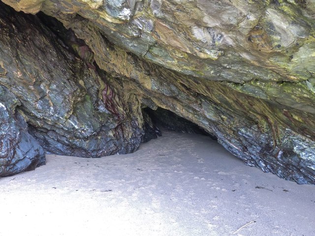
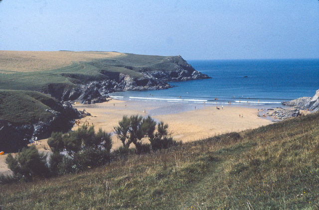
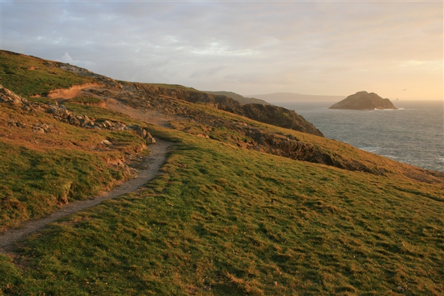
Monk is a small island located off the coast of Cornwall, in southwestern England. It is situated in the Celtic Sea, approximately 1.5 kilometers from the mainland. The island covers an area of about 2.5 hectares and is characterized by rugged cliffs, sandy beaches, and lush vegetation.

Monk Island is known for its rich biodiversity and is home to a variety of bird species, including gulls, cormorants, and puffins. The island also supports a diverse range of plant life, with heather, gorse, and wildflowers dotting the landscape.

Access to Monk Island is limited, with only occasional boat trips organized by local tour operators. Visitors to the island can explore its craggy coastline, go birdwatching, or simply enjoy the tranquility of this secluded spot. The island offers stunning views of the surrounding sea and the nearby mainland.

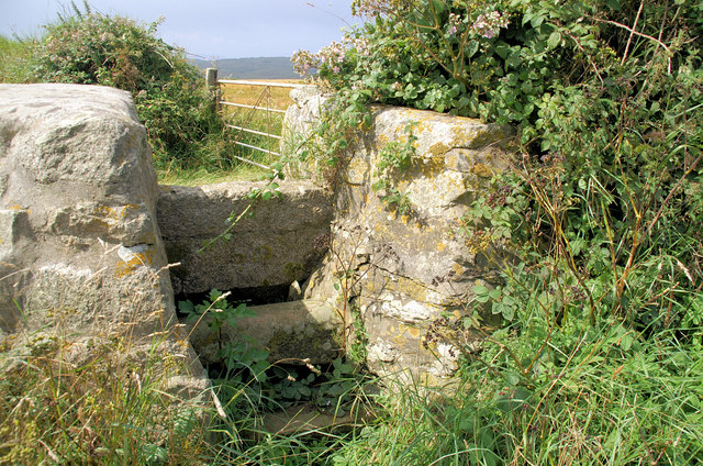
Monk Island has a fascinating history, with evidence of human habitation dating back to prehistoric times. Ruins of an ancient monastery, which is believed to have been the inspiration for the island's name, can still be seen. The island’s isolation provided a safe haven for monks seeking solitude and spiritual retreat during the medieval period.

Today, Monk Island remains an idyllic destination for nature lovers and history enthusiasts alike. Its unspoiled beauty and peaceful atmosphere make it a popular spot for those seeking a quiet escape from the bustling mainland.

If you have any feedback on the listing, please let us know in the comments section below.

Monk Images

Images are sourced within 2km of 50.389822/-5.1499724 or Grid Reference SW7659. Thanks to Geograph Open Source API. All images are credited.

A lone dog walker on the beach at Holywell Bay, Cornwall
Cave entrance on Holywell Beach, Cornwall
Looking out of the cave entrance to Gull Rocks, Holywell Beach
Interior of a cave on Holywell Beach, Cornwall Taken with available light
Interior of a cave on Holywell Beach, Cornwall
Taken with available light
Interior of a cave on Holywell Beach, Cornwall Taken with flash
Interior of a cave on Holywell Beach, Cornwall
Taken with flash
Cave entrance on Holywell Beach, Cornwall
Rocks at the Northern end of Holywell Beach, Cornwall
Rocky cliffs at the Northern end of Holywell Beach, Cornwall
Porth (or "Polly") Joke beach, Cornwall 1979 Overlooking Porth Joke beach (or Polly Joke as the locals refer to it), from the footpath from West Pentire. Taken August 1979.
Porth (or "Polly") Joke beach, Cornwall 1979
Overlooking Porth Joke beach (or Polly Joke as the locals refer to it), from the footpath from West Pentire. Taken August 1979.
Footbridge at head of Porth Joke near W Pentire
Porth Joke near W Pentire
Footbridge at Porth Joke No need for wet feet crossing the stream at Porth Joke. Porth Joke is a narrow sandy inlet which attracts relatively few visitors even in the height of Summer. The only way to get here is to walk.
Footbridge at Porth Joke
No need for wet feet crossing the stream at Porth Joke. Porth Joke is a narrow sandy inlet which attracts relatively few visitors even in the height of Summer. The only way to get here is to walk.
Poppies and Corn Marigolds at West Pentire Looking down on Porth Joke beach.
Poppies and Corn Marigolds at West Pentire
Looking down on Porth Joke beach.
Field of poppies above Porth Joke beach
Poppies at West Pentire
Field boundary at West Pentire Alongside a field of Corn Marigolds.
Field boundary at West Pentire
Alongside a field of Corn Marigolds.
Show me another place!

Monk is located at Grid Ref: SW7659 (Lat: 50.389822, Lng: -5.1499724)

Unitary Authority: Cornwall

Police Authority: Devon and Cornwall

What 3 Words

///offhand.woods.aimed. Near Perranporth, Cornwall

Related Wikis

Holywell, Cornwall

Holywell (Cornish: Tregew) is a coastal village in the civil parish of Cubert (Cornish: Lannowyn), in north Cornwall, England, United Kingdom. It is at...

Kelsey Head

Kelsey Head is a coastal Site of Special Scientific Interest (SSSI) and headland in north Cornwall, England, UK, noted for its biological interest. The...

Ellenglaze

Ellenglaze (Cornish: Elynglas) is a hamlet near the village of Cubert north of Perranporth in Cornwall, England. It lies close to the edge of Penhale...

West Pentire

West Pentire (Cornish: Pentir, meaning promontory) is a hamlet on the north coast of Cornwall in England, United Kingdom. It is located within the civil...

Nearby Amenities

Located within 500m of 50.389822,-5.1499724
Source: PGS
Lat/Long: 50.3925681/-5.1448359
Source: PGS
Lat/Long: 50.3919936/-5.1453809
Source: PGS
Lat/Long: 50.3913215/-5.1460831
Source: PGS
Lat/Long: 50.3908301/-5.146559
Source: PGS
Lat/Long: 50.3904323/-5.1467928
Source: PGS
Lat/Long: 50.3888905/-5.1435399
Source: PGS
Lat/Long: 50.3900951/-5.1469516
Source: PGS
Lat/Long: 50.3902538/-5.1471351
Source: PGS
Lat/Long: 50.3901494/-5.1488753
Source: PGS
Lat/Long: 50.3897798/-5.1496714
Source: PGS
Lat/Long: 50.389407/-5.1502636
Source: PGS
Lat/Long: 50.3894614/-5.1507603
Source: PGS
Lat/Long: 50.3895255/-5.1517144
Source: PGS
Lat/Long: 50.3893604/-5.15481
Source: PGS
Lat/Long: 50.389451/-5.1549156
Source: PGS
Lat/Long: 50.3893713/-5.154965
Source: PGS
Lat/Long: 50.3894059/-5.1551731
Source: PGS
Lat/Long: 50.3894343/-5.1556715
Source: PGS
Lat/Long: 50.389635/-5.1565625
Source: PGS
Lat/Long: 50.3889462/-5.1563179
Source: PGS
Lat/Long: 50.3887571/-5.1566269
Source: PGS
Lat/Long: 50.3886886/-5.1564166
Source: PGS
Lat/Long: 50.3885806/-5.1563758
Source: PGS
Lat/Long: 50.3880853/-5.1553947
Source: PGS
Lat/Long: 50.387891/-5.1549934
Source: PGS
Lat/Long: 50.387742/-5.154705
Source: PGS
Lat/Long: 50.3876096/-5.1543223
Source: PGS
Lat/Long: 50.3874334/-5.1544553
Source: PGS
Lat/Long: 50.3873204/-5.155793
Source: PGS
Lat/Long: 50.3867712/-5.1551458
Source: PGS
Lat/Long: 50.3865828/-5.1545916
Source: PGS
Lat/Long: 50.3862961/-5.1537757
Source: PGS
Lat/Long: 50.3863372/-5.1541131
Source: PGS
Lat/Long: 50.3857509/-5.1528466
ELF Transmitter
Communication Military: yes
Man Made: antenna
Lat/Long: 50.3863714/-5.1495906
ELF Transmitter
Communication Military: yes
Man Made: antenna
Lat/Long: 50.387275/-5.1511988
ELF Transmitter
Communication Military: yes
Man Made: antenna
Lat/Long: 50.3882731/-5.1528307
ELF Transmitter
Communication Military: yes
Man Made: antenna
Lat/Long: 50.388178/-5.1497182
ELF Transmitter
Communication Military: yes
Man Made: antenna
Lat/Long: 50.3878284/-5.1529809
ELF Transmitter
Communication Military: yes
Man Made: antenna
Lat/Long: 50.3867206/-5.1532929
ELF Transmitter
Communication Military: yes
Man Made: antenna
Lat/Long: 50.3863751/-5.1529843
ELF Transmitter
Communication Military: yes
Man Made: antenna
Lat/Long: 50.3880978/-5.1539558
Communications transmitter
Man Made: mast
Lat/Long: 50.3862313/-5.1484906
Holywell Bay School of Surf
Sport: surfing
Lat/Long: 50.391352/-5.145205
Barrier: kissing_gate
Lat/Long: 50.3893836/-5.1498226
The data included in this document is from www.openstreetmap.org. The data is made available under ODbL.

Have you been to Monk?

Leave your review of Monk below (or comments, questions and feedback).