An t-Iasgair

Island in Inverness-shire

Scotland

An t-Iasgair

An t-Iasgair 'The fisherman', a rocky isle in the Minch, seen here from Camas Mor on Skye. The structure visible on the top of it is a navigation beacon.
An t-Iasgair Credit: John Allan

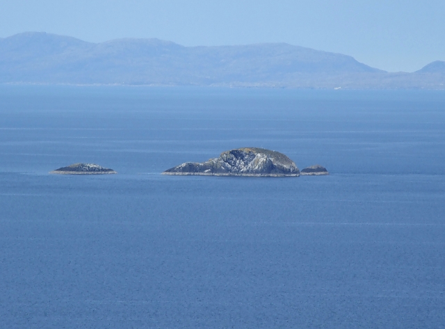
An t-Iasgair, also known as The Fisher Island, is located in Inverness-shire, Scotland. Situated off the west coast of the Scottish Highlands, it is part of the Inner Hebrides archipelago. The island covers an area of approximately 25 hectares and is known for its rugged beauty and rich history.

An t-Iasgair is accessible by boat and is a popular destination for those seeking tranquility and a connection with nature. The island is characterized by its dramatic cliffs, sandy beaches, and picturesque coastal landscapes. Its diverse flora and fauna make it an ideal spot for birdwatching and wildlife enthusiasts.

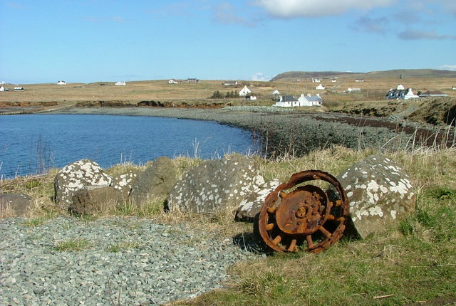
Historically, An t-Iasgair was primarily inhabited by fishermen, hence its name. The remnants of old fishing huts and equipment can still be found on the island, serving as a reminder of its past. The island also played a role in the smuggling trade during the 18th and 19th centuries, with hidden caves and coves used to store contraband.

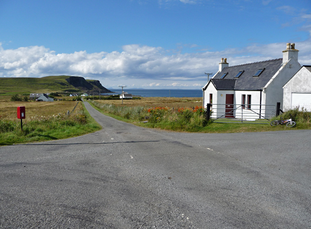
Today, An t-Iasgair is largely uninhabited, with only a few seasonal residents. It offers a range of outdoor activities such as hiking, camping, and fishing. Visitors can explore the island's rugged coastline, walk along its pristine beaches, or simply enjoy the peacefulness of the surroundings.

An t-Iasgair is a hidden gem, tucked away in the Scottish Highlands, offering a unique and unspoiled experience for those who venture to its shores.

If you have any feedback on the listing, please let us know in the comments section below.

An t-Iasgair Images

Images are sourced within 2km of 57.684841/-6.4333374 or Grid Reference NG3574. Thanks to Geograph Open Source API. All images are credited.

An t-Iasgair 'The fisherman', a rocky isle in the Minch, seen here from Camas Mor on Skye. The structure visible on the top of it is a navigation beacon.
An t-Iasgair
'The fisherman', a rocky isle in the Minch, seen here from Camas Mor on Skye. The structure visible on the top of it is a navigation beacon.
Yacht passing An t-Iasgair On the right is the An t-Iasgair skerry, which has two smaller attendant skerries, while to the left, and much further away, are Gaeilavore Island and Lord Macdonald's Table (Am Bord).
Yacht passing An t-Iasgair
On the right is the An t-Iasgair skerry, which has two smaller attendant skerries, while to the left, and much further away, are Gaeilavore Island and Lord Macdonald's Table (Am Bord).
An t-Iasgair A fissure has been widened to form a natural window through this rock.
An t-Iasgair
A fissure has been widened to form a natural window through this rock.
An t-Iasgair An t-Iasgair (the fisherman) is a small islet which lies off the west coast of Skye's Trotternish Peninsula - seen in the background. The houses are the settlement of Peingown.
An t-Iasgair
An t-Iasgair (the fisherman) is a small islet which lies off the west coast of Skye's Trotternish Peninsula - seen in the background. The houses are the settlement of Peingown.
An t-Iasgair rocks from Duntulm A clear view over to the rocks of An t-Iasgair taken from near Flora MacDonald's monument on the Trotternish Peninsula. An t-Iasgair is the large obvious rock, with tiny Sgeir nan Ruideag off to the right, and the flat conical An Dubh Sgeir a little way off to the left. The mountains behind are on Harris about 20 miles away to the Northwest. To see these islets in silhouette, see <a href="https://www.geograph.org.uk/photo/866827">NG3574 : An t-Iasgair, An Dubh Sgeir & Sgeir nan Ruideag silhouette</a>
An t-Iasgair rocks from Duntulm
A clear view over to the rocks of An t-Iasgair taken from near Flora MacDonald's monument on the Trotternish Peninsula. An t-Iasgair is the large obvious rock, with tiny Sgeir nan Ruideag off to the right, and the flat conical An Dubh Sgeir a little way off to the left. The mountains behind are on Harris about 20 miles away to the Northwest. To see these islets in silhouette, see NG3574 : An t-Iasgair, An Dubh Sgeir & Sgeir nan Ruideag silhouette
An t-Iasgair, An Dubh Sgeir & Sgeir nan Ruideag silhouette Taken from near Duntulm Castle looking pretty-much due west. An t-Iasgair is the large obvious rock, with tiny Sgair nan Ruideag off to the right (not the little sliver which is part of An t-Iasgair), and An Dubh Sgeir a little way off to the left. As can be seen this photo was taken from a slightly more northerly position than <a href="https://www.geograph.org.uk/photo/866824">NG3574 : An t-Iasgair rocks from Duntulm</a> allowing the gap between the northern two islets to be more clearly visible.
An t-Iasgair, An Dubh Sgeir & Sgeir nan Ruideag silhouette
Taken from near Duntulm Castle looking pretty-much due west. An t-Iasgair is the large obvious rock, with tiny Sgair nan Ruideag off to the right (not the little sliver which is part of An t-Iasgair), and An Dubh Sgeir a little way off to the left. As can be seen this photo was taken from a slightly more northerly position than NG3574 : An t-Iasgair rocks from Duntulm allowing the gap between the northern two islets to be more clearly visible.
An t-Iasgair A close up of An t-Iasgair (digital zoom from <a href="https://www.geograph.org.uk/photo/866824">NG3574 : An t-Iasgair rocks from Duntulm</a>), the main islette of this group of three rocks in the Little Minch between Skye and Harris. The tiny Sgeir nan Ruideag with prominent horizontal banding lies just to the right like the larger island's pup.
An t-Iasgair
A close up of An t-Iasgair (digital zoom from NG3574 : An t-Iasgair rocks from Duntulm), the main islette of this group of three rocks in the Little Minch between Skye and Harris. The tiny Sgeir nan Ruideag with prominent horizontal banding lies just to the right like the larger island's pup.
An t-Iasgair rocks Three skerries off the north-west corner of the Isle of Skye. From left to right Sgeir nan Ruideag, An t-Iasgair (the highest islet in the group) and An Dubh Sgeir. The cliffs beyond are on the Isle of Skye behind Duntulm.
An t-Iasgair rocks
Three skerries off the north-west corner of the Isle of Skye. From left to right Sgeir nan Ruideag, An t-Iasgair (the highest islet in the group) and An Dubh Sgeir. The cliffs beyond are on the Isle of Skye behind Duntulm.
Show me another place!

An t-Iasgair is located at Grid Ref: NG3574 (Lat: 57.684841, Lng: -6.4333374)

Unitary Authority: Highland

Police Authority: Highlands and Islands

What 3 Words

///disjunctive.leanings.bickering. Near Uig, Highland

Related Wikis

Bornesketaig

Bornesketaig, Scottish Gaelic Borgh na Sgiotaig, is a dispersed crofting settlement in Trotternish on the Isle of Skye. == Broch == A broch once stood...

Beaton's Cottage

Beaton's Cottage (also known as Beaton's Croft) is a croft dwelling in Bornesketaig, Isle of Skye, Scotland, near the island's northern tip. A Category...

Hungladder

Hungladder is a small village on north west coast of the Trotternish peninsula in Kilmuir, Portree, Isle of Skye, Scottish Highlands and is in the Scottish...

Skye Museum of Island Life

The Skye Museum of Island Life is a museum in Kilmuir, Skye, Scotland, which is dedicated to preserving a township of thatched cottages as they would have...

Have you been to An t-Iasgair?

Leave your review of An t-Iasgair below (or comments, questions and feedback).