Cairn na Burgh Beg

Island in Argyllshire

Scotland

Cairn na Burgh Beg

Cairn na Burgh Beg & More from Coll ferry terminal Taken from beside the ferry terminal south of Arinagour on Coll looking over to the northernmost two of the Treshnish Isles. On the left is Cairn na Burgh Beg with the larger Cairn na Burgh More on the right. The remains of a chapel (the triangular gables can be seen) and part of the ancient castle are atop the larger island. Distance from Coll is c.15km (10½ miles)
Cairn na Burgh Beg & More from Coll ferry terminal Credit: Rob Farrow

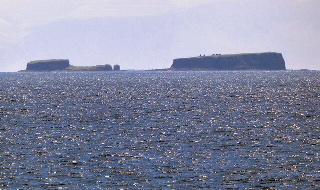
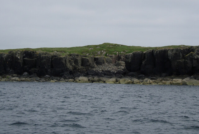
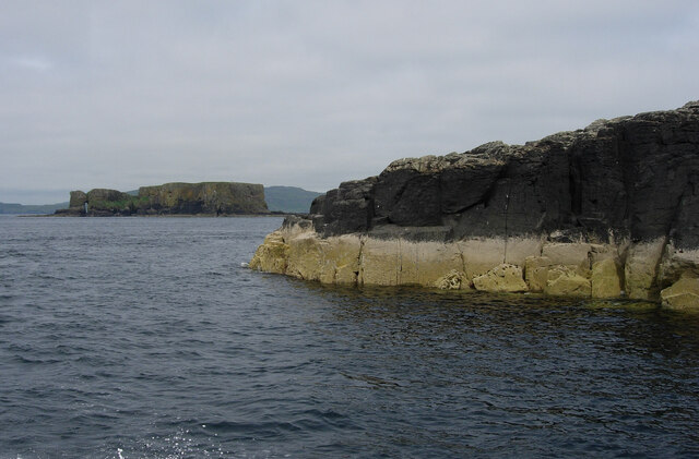
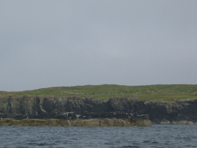
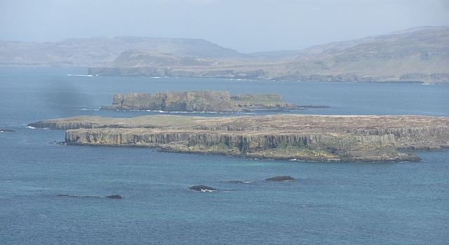
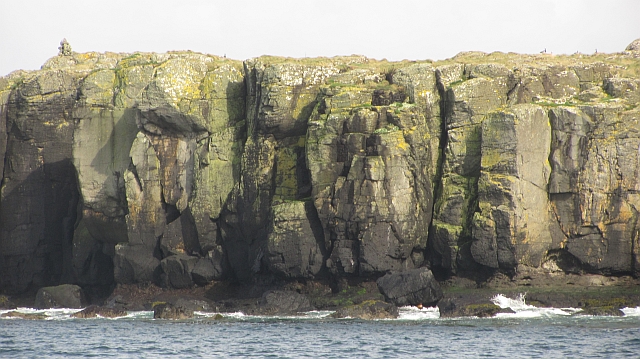
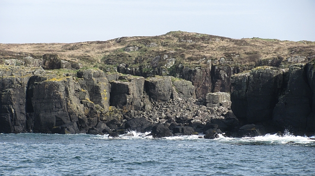
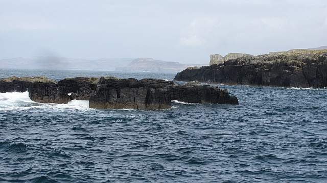
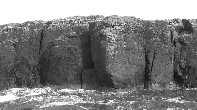
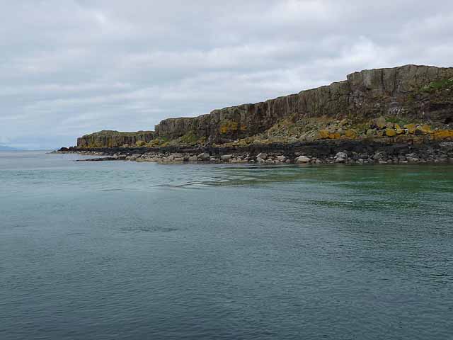
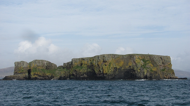
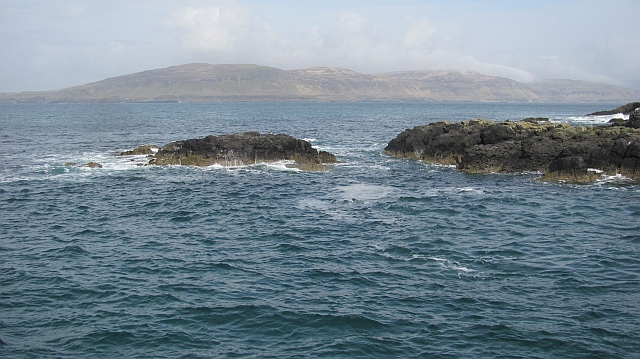
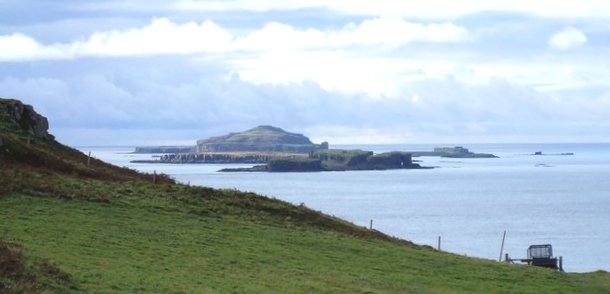
Cairn na Burgh Beg is a small island located in Argyllshire, Scotland. It is situated in the Inner Hebrides, just off the coast of the Isle of Mull. The island is known for its rugged coastline, dramatic cliffs, and stunning views of the surrounding sea.

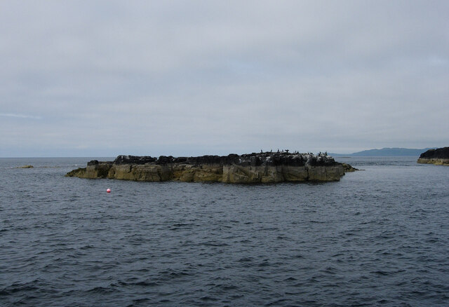
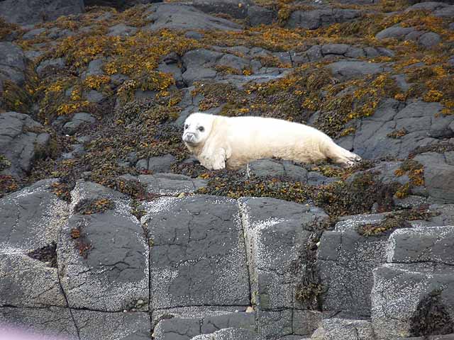
Cairn na Burgh Beg is uninhabited and is primarily used for grazing by local farmers. The island is home to a variety of bird species, including puffins, guillemots, and razorbills, making it a popular spot for birdwatching.

The island is also known for its archaeological significance, with a number of ancient structures and ruins scattered across its landscape. One of the most notable features is a large cairn, or burial mound, from which the island gets its name.

Access to Cairn na Burgh Beg is limited, with no regular ferry service or accommodations on the island. However, visitors can arrange boat trips or guided tours to explore the island and its natural beauty. Overall, Cairn na Burgh Beg is a hidden gem in the Inner Hebrides, offering a peaceful and remote escape for those looking to explore Scotland's rugged coastline.

If you have any feedback on the listing, please let us know in the comments section below.

Cairn na Burgh Beg Images

Images are sourced within 2km of 56.519546/-6.3770457 or Grid Reference NM3044. Thanks to Geograph Open Source API. All images are credited.

Cairn na Burgh Beg & More from Coll ferry terminal Taken from beside the ferry terminal south of Arinagour on Coll looking over to the northernmost two of the Treshnish Isles. On the left is Cairn na Burgh Beg with the larger Cairn na Burgh More on the right. The remains of a chapel (the triangular gables can be seen) and part of the ancient castle are atop the larger island. Distance from Coll is c.15km (10½ miles)
Cairn na Burgh Beg & More from Coll ferry terminal
Taken from beside the ferry terminal south of Arinagour on Coll looking over to the northernmost two of the Treshnish Isles. On the left is Cairn na Burgh Beg with the larger Cairn na Burgh More on the right. The remains of a chapel (the triangular gables can be seen) and part of the ancient castle are atop the larger island. Distance from Coll is c.15km (10½ miles)
Small beach on Fladda On the way back from a trip to Lunga.
Small beach on Fladda
On the way back from a trip to Lunga.
Island off Fladda On the way back from a trip to Lunga.
Island off Fladda
On the way back from a trip to Lunga.
North end of Fladda Looking towards Cairn na Burgh More.
North end of Fladda
Looking towards Cairn na Burgh More.
Fladda Low cliffs on the west coast of Fladda in the Treshnish Isles.
Fladda
Low cliffs on the west coast of Fladda in the Treshnish Isles.
Fladda View towards Mull over Fladda and the fortified Burgh islands from Cruachan on Lunga.
Fladda
View towards Mull over Fladda and the fortified Burgh islands from Cruachan on Lunga.
Crag, Fladda 20m sea cliffs on the west side of Fladda.
Crag, Fladda
20m sea cliffs on the west side of Fladda.
Boulder beach, Fladda
Skerry off Fladda
Skerry off Fladda
Crags, north end of Fladda Fladda is a flat topped island surrounded by low steep crags.
Crags, north end of Fladda
Fladda is a flat topped island surrounded by low steep crags.
South-west coast of Fladda One of the larger Treshnish Islands.
South-west coast of Fladda
One of the larger Treshnish Islands.
Atlantic Grey Seal pup Making pitiful sounds on the shoreline at the southern end of Fladda.
Atlantic Grey Seal pup
Making pitiful sounds on the shoreline at the southern end of Fladda.
Cairn na Burgh More One of two fortified islands at the north end of the Treshnish chain.
Cairn na Burgh More
One of two fortified islands at the north end of the Treshnish chain.
Cairn na Burgh More Waves break around the entrance to the rock arch on Cairn na Burgh More.
Cairn na Burgh More
Waves break around the entrance to the rock arch on Cairn na Burgh More.
Cairn na Burgh More Big steep crags on the west side of the island.
Cairn na Burgh More
Big steep crags on the west side of the island.
Rocks off Cairn na Burgh Beg Wave cut platform off the northern side of Cairn na Burgh Beg, a small fortified island.
Rocks off Cairn na Burgh Beg
Wave cut platform off the northern side of Cairn na Burgh Beg, a small fortified island.
Cairn na Burgh Beg Small fortified island, which saw action in the 1715 Jacobite uprising. The island is typical Treshnish, a low flat base with a square cut step of another resistant lava flow above. This stepped landscape is common to a lot of flood basalt areas such as Mull, Skye and the Faeroes and is known as a trap landscape after the stepped appearance.
Cairn na Burgh Beg
Small fortified island, which saw action in the 1715 Jacobite uprising. The island is typical Treshnish, a low flat base with a square cut step of another resistant lava flow above. This stepped landscape is common to a lot of flood basalt areas such as Mull, Skye and the Faeroes and is known as a trap landscape after the stepped appearance.
Beacon, Cairn na Burgh More Navigation beacon near the island's high point.
Beacon, Cairn na Burgh More
Navigation beacon near the island's high point.
Show me another place!

Cairn na Burgh Beg is located at Grid Ref: NM3044 (Lat: 56.519546, Lng: -6.3770457)

Unitary Authority: Argyll and Bute

Police Authority: Argyll and West Dunbartonshire

What 3 Words

///detective.evaporate.drank. Near Calgary, Argyll & Bute

Related Wikis

Cairn na Burgh Beag

Cairn na Burgh Beag is one of the Treshnish Isles in the Inner Hebrides, Scotland. Cairn na Burgh Beag is the smaller of the two "Carnburgs" (as they...

Cairnburgh Castle

Cairnburgh Castle is a ruined castle that is located on the islands of Cairn na Burgh Mòr and Cairn na Burgh Beag, Argyll and Bute, Scotland. These islands...

Cairn na Burgh Mòr

Cairn na Burgh Mòr (also Cairnburgh More) is one of the Treshnish Isles in the Inner Hebrides of Scotland. Cairn na Burgh Mòr is the larger of the two...

Fladda, Treshnish Isles

Fladda is the northernmost of the Treshnish Isles. Its name comes from the Old Norse Flat-ey meaning "flat island". Fladda is owned by the Hebridean Trust...

Nearby Amenities

Located within 500m of 56.519546,-6.3770457
Source: PGS
Lat/Long: 56.5187492/-6.3764086
Source: PGS
Lat/Long: 56.518774/-6.3781281
Source: PGS
Lat/Long: 56.518927/-6.3786338
Source: PGS
Lat/Long: 56.5195849/-6.3785959
Source: PGS
Lat/Long: 56.5199792/-6.3791459
Source: PGS
Lat/Long: 56.5200478/-6.378861
Source: PGS
Lat/Long: 56.5198531/-6.3782608
Source: PGS
Lat/Long: 56.5199596/-6.3777931
Source: PGS
Lat/Long: 56.5202473/-6.376777
Source: PGS
Lat/Long: 56.5196725/-6.3761167
Source: PGS
Lat/Long: 56.5194849/-6.3764611
Source: PGS
Lat/Long: 56.5174846/-6.3783346
Source: PGS
Lat/Long: 56.5176779/-6.3788828
Source: PGS
Lat/Long: 56.5180578/-6.3789585
Source: PGS
Lat/Long: 56.5179969/-6.3783593
Source: PGS
Lat/Long: 56.5170567/-6.3821842
Source: PGS
Lat/Long: 56.5171986/-6.3823714
Source: PGS
Lat/Long: 56.5171487/-6.3823819
Source: PGS
Lat/Long: 56.5172208/-6.3825041
Source: PGS
Lat/Long: 56.5173651/-6.3830008
Source: PGS
Lat/Long: 56.5174071/-6.383087
Source: PGS
Lat/Long: 56.5175051/-6.3831146
Source: PGS
Lat/Long: 56.5185427/-6.3828929
Source: PGS
Lat/Long: 56.5184247/-6.3831803
Source: PGS
Lat/Long: 56.5185548/-6.3835695
Source: PGS
Lat/Long: 56.5185979/-6.383241
Source: PGS
Lat/Long: 56.5192446/-6.3825023
Source: PGS
Lat/Long: 56.5194163/-6.3813343
Source: PGS
Lat/Long: 56.518944/-6.380572
Source: PGS
Lat/Long: 56.5180747/-6.3802275
Source: PGS
Lat/Long: 56.5179601/-6.3804176
Source: PGS
Lat/Long: 56.5177195/-6.3806094
Source: PGS
Lat/Long: 56.5174944/-6.3809983
Source: PGS
Lat/Long: 56.5172978/-6.3814718
Slochd Bran
Natural: bay
Lat/Long: 56.5183268/-6.3836209
Natural: arch
Lat/Long: 56.5188081/-6.3830781
The data included in this document is from www.openstreetmap.org. The data is made available under ODbL.

Have you been to Cairn na Burgh Beg?

Leave your review of Cairn na Burgh Beg below (or comments, questions and feedback).