Barton Hill

Settlement in Yorkshire Ryedale

England

Barton Hill

Farmland, Blue Coat Farm
Farmland, Blue Coat Farm Credit: JThomas

Barton Hill is a small village located in the county of Yorkshire, England. Situated in the beautiful countryside, it lies about 10 miles southwest of the city of York. The village is known for its picturesque setting, surrounded by rolling hills and green pastures.

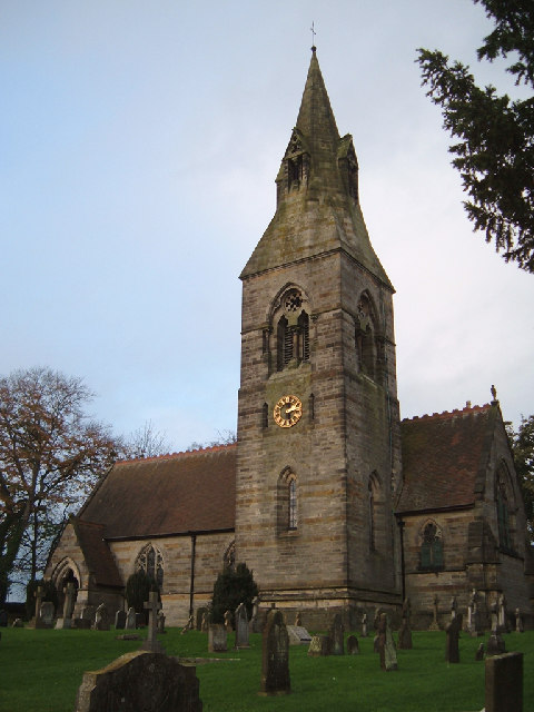
Barton Hill is a close-knit community with a population of around 500 residents. The village is characterized by its charming and well-preserved traditional architecture, including stone-built houses and cottages. The local church, St. Mary's, stands as a prominent landmark, dating back to the 12th century and providing a glimpse into the area's rich history.

Despite its small size, Barton Hill offers a range of amenities to its residents. The village has a primary school, a village hall, and a local pub, which serves as a social hub for the community. Additionally, there are several walking and cycling trails in the surrounding countryside, allowing residents and visitors to enjoy the natural beauty of the area.

Barton Hill's location provides easy access to nearby attractions and amenities. The city of York, with its historic sites, cultural events, and shopping opportunities, is just a short drive away. The village also benefits from good transport links, with a regular bus service connecting it to the surrounding towns and cities.

Overall, Barton Hill is a peaceful and idyllic village, offering a tranquil lifestyle amidst the stunning Yorkshire countryside. Its rich history, friendly community, and convenient location make it an attractive place to live or visit.

If you have any feedback on the listing, please let us know in the comments section below.

Barton Hill Images

Images are sourced within 2km of 54.071118/-0.918318 or Grid Reference SE7064. Thanks to Geograph Open Source API. All images are credited.

Farmland, Blue Coat Farm
Farmland near Blue Coat Farm
Road  to  Foston At the junction of the minor farm road.
Road to Foston
At the junction of the minor farm road.
Farm  road  from  Blue  Coat  Farm At its junction with the Thornton le Clay / Foston road
Farm road from Blue Coat Farm
At its junction with the Thornton le Clay / Foston road
Over  Rape  fields  toward  Foston From the farm road to Blue Coat Farm
Over Rape fields toward Foston
From the farm road to Blue Coat Farm
Blue  Coat  Farm End of the road, footpath into the field.
Blue Coat Farm
End of the road, footpath into the field.
Scarborough  to  York  Line Looking west from the footpath crossing
Scarborough to York Line
Looking west from the footpath crossing
Summer  2012  Record  Rainfall Carry waterproofs on all walks
Summer 2012 Record Rainfall
Carry waterproofs on all walks
Farm  road  to  Red  House
Farm road to Red House
Bridleway towards Foston Leading from Flaxton.
Bridleway towards Foston
Leading from Flaxton.
Blue Coat Farm Looking from a bridleway towards Blue Coat Farm.
Blue Coat Farm
Looking from a bridleway towards Blue Coat Farm.
Track towards Foston Passing Blue Coat Farm.
Track towards Foston
Passing Blue Coat Farm.
Track to Foston Leading from Flaxton.
Track to Foston
Leading from Flaxton.
Bridleway to Flaxton Leading through Blue Coat Farm and across the railway to Flaxton.
Bridleway to Flaxton
Leading through Blue Coat Farm and across the railway to Flaxton.
Cows near Foston Leaning over a gate looking at a field of cows.
Cows near Foston
Leaning over a gate looking at a field of cows.
Foston The small village of Foston looking in the direction of Thornton.
Foston
The small village of Foston looking in the direction of Thornton.
Foston Lane from Foston Gates level crossing
Blue Coat Farm from railway
Show me another place!

Barton Hill is located at Grid Ref: SE7064 (Lat: 54.071118, Lng: -0.918318)

Division: North Riding

Administrative County: North Yorkshire

District: Ryedale

Police Authority: North Yorkshire

What 3 Words

///fussy.crafts.passenger. Near Sheriff Hutton, North Yorkshire

Nearby Locations

Barton Hill Sweet Hill

Related Wikis

Nearby Amenities

Located within 500m of 54.071118,-0.918318
Barton Hill
Note: Local knowledge says that "Barton Hill is W of A64"; but village marker moved into actual village, N of railway
Place: hamlet
Source: road sign;Local Knowledge
Wikidata: Q4865639
Lat/Long: 54.0714821/-0.9197144
Railway: level_crossing
Lat/Long: 54.0698636/-0.9188738
Bus Stop
Bus: yes
Naptan AtcoCode: 3200YNF10330
Naptan NaptanCode: 32010330
Public Transport: platform
Lat/Long: 54.072289/-0.9164516
Bus Stop
Bus: yes
Note: bus stop has moved now that junction has been remodelled.
Public Transport: platform
Source: survey
Lat/Long: 54.0738878/-0.913484
Post Box
Post Box Mounting: wooden_post
Post Box Type: lamp
Lat/Long: 54.0701385/-0.918862
Crossing
Crossing: uncontrolled
Crossing Markings: yes
Crossing Signals: no
Tactile Paving: no
Lat/Long: 54.0718919/-0.9173995
Crossing
Crossing Island: yes
Kerb: lowered
Tactile Paving: yes
Lat/Long: 54.0730637/-0.9157281
Crossing
Crossing: uncontrolled
Crossing Markings: yes
Crossing Signals: no
Kerb: lowered
Tactile Paving: yes
Lat/Long: 54.0721833/-0.9173188
Crossing
Crossing: uncontrolled
Crossing Markings: yes
Crossing Signals: no
Kerb: lowered
Tactile Paving: yes
Lat/Long: 54.0721489/-0.9169835
Railway: level_crossing
Lat/Long: 54.0699076/-0.9188862
Note: blocked by fence
Lat/Long: 54.0731723/-0.9152042
Phone
Emergency: phone
Lat/Long: 54.0738281/-0.9136248
Barrier: stile
Dog Gate: yes
Step Count: 2
Stile: stepover
Lat/Long: 54.0700044/-0.9232034
Barrier: stile
Dog Gate: yes
Step Count: 2
Stile: stepover
Lat/Long: 54.0697214/-0.9228595
Crossing
Lat/Long: 54.0730254/-0.9158298
The data included in this document is from www.openstreetmap.org. The data is made available under ODbL.

Have you been to Barton Hill?

Leave your review of Barton Hill below (or comments, questions and feedback).