Cròcach

Island in Ross-shire

Scotland

Cròcach

Crystal clear seas off North West coast of Na h-Eileanan an Iar View to about 3 metres depth from RIB floating in lagoon between Pabaigh Mor and Pabaigh Beag.  See also <a href="https://www.geograph.org.uk/photo/1120209">NB1038 : Lagoon on Pabbay Mor</a>
Crystal clear seas off North West coast of Na h-Eileanan an Iar Credit: Hazel Hambidge

Cròcach is a small island located off the coast of Ross-shire, Scotland. With a total area of approximately 3 square miles, it is a picturesque and secluded destination for nature enthusiasts. The island is accessible only by boat, adding to its charm and exclusivity.

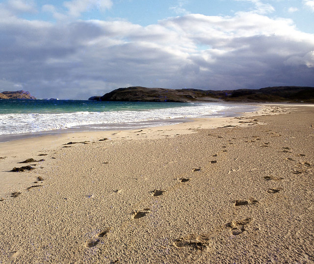
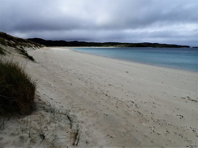
Cròcach is known for its rugged landscape, featuring rolling hills, rocky cliffs, and sandy beaches. The island is covered in lush green vegetation, with a variety of plant species thriving in its fertile soils. The diverse ecosystem supports a wide range of wildlife, including various bird species and marine life.

The island's coastline offers breathtaking views of the surrounding sea, and visitors can enjoy activities such as fishing, kayaking, and swimming in the clear waters. The beaches are often deserted, providing a peaceful and tranquil setting for relaxation.

Cròcach has a rich history, with evidence of human occupation dating back thousands of years. There are remnants of ancient settlements and burial sites, providing a glimpse into the island's past. Visitors can explore these historical sites and learn about the island's fascinating heritage.

Despite its small size, Cròcach has a close-knit community of residents who live in a few scattered houses. The island has limited amenities, with no shops or restaurants, so visitors are advised to bring their own supplies. However, the warm and welcoming locals make up for the lack of facilities, ensuring a memorable and authentic experience for anyone who visits Cròcach.

If you have any feedback on the listing, please let us know in the comments section below.

Cròcach Images

Images are sourced within 2km of 58.230583/-6.9153746 or Grid Reference NB1137. Thanks to Geograph Open Source API. All images are credited.

Crystal clear seas off North West coast of Na h-Eileanan an Iar View to about 3 metres depth from RIB floating in lagoon between Pabaigh Mor and Pabaigh Beag.  See also <a href="https://www.geograph.org.uk/photo/1120209">NB1038 : Lagoon on Pabbay Mor</a>
Crystal clear seas off North West coast of Na h-Eileanan an Iar
View to about 3 metres depth from RIB floating in lagoon between Pabaigh Mor and Pabaigh Beag. See also NB1038 : Lagoon on Pabbay Mor
Tràigh na Beirigh In the 1960's this was a deserted beach.  Now it has to be shared with caravanners.
Tràigh na Beirigh
In the 1960's this was a deserted beach. Now it has to be shared with caravanners.
Tràigh na Beirigh A perfect crescent beach
Tràigh na Beirigh
A perfect crescent beach
A rocky buttress contains Tràigh na Beirigh
Traigh na Berie
Traigh na Berie
Tràigh na Beirigh from the east
Sunrise, Gridig
Sunrise, Gridig
Tràigh Teinish
Tràigh Teinish
Beach at Pabaigh Mor
Geodh'an Tuill penetrates Pabaigh Mor Pabaigh More has a tidally flooded low-lying area in the middle of the island (at one time used for buffering lobsters) which connects to the open sea over a reef to the northwest, and through a couple of rocky channels heading northeast. It's clear that those channels must have started the same way as this cave, which has penetrated right to the lagoon (from which it is separated only by a storm beach thrown up by waves entering the cave) and, on a geological timescale, is just about at the end of its life. Although one of our group walked over the arch, and once we'd paddled round the island several of us entered the cave from the sea, it is not the most confidence-inspiring roof, especially at this landward end.
Geodh'an Tuill penetrates Pabaigh Mor
Pabaigh More has a tidally flooded low-lying area in the middle of the island (at one time used for buffering lobsters) which connects to the open sea over a reef to the northwest, and through a couple of rocky channels heading northeast. It's clear that those channels must have started the same way as this cave, which has penetrated right to the lagoon (from which it is separated only by a storm beach thrown up by waves entering the cave) and, on a geological timescale, is just about at the end of its life. Although one of our group walked over the arch, and once we'd paddled round the island several of us entered the cave from the sea, it is not the most confidence-inspiring roof, especially at this landward end.
Traigh na Berie
Traigh na Berie
Tràigh na Beirigh and Pabaigh Mòr
Tràigh na Beirigh
Tràigh na Beirigh
Traigh na Beirigh beach Lewis Looking out from the beach just in front of the Caravan site towards the headland at Kneep on the left and Pabaigh Mor on the right.
Traigh na Beirigh beach Lewis
Looking out from the beach just in front of the Caravan site towards the headland at Kneep on the left and Pabaigh Mor on the right.
Traigh na Beirigh beach Lewis Looking down the length of the beach towards Kneep.
Traigh na Beirigh beach Lewis
Looking down the length of the beach towards Kneep.
View from near Bhaltos towards Pabaigh Mor
Traigh na Beirigh
Traigh na Beirigh
Show me another place!

Cròcach is located at Grid Ref: NB1137 (Lat: 58.230583, Lng: -6.9153746)

Unitary Authority: Na h-Eileanan an Iar

Police Authority: Highlands and Islands

What 3 Words

///proofread.saves.judges. Near Carloway, Na h-Eileanan Siar

Related Wikis

Vacsay

Vacsay (Scottish Gaelic: Bhacsaigh from Old Norse "bakkiey" meaning "peat bank island") is one of the Outer Hebrides. It is off the west coast of Lewis...

Pabaigh Mòr

Pabay Mòr or Pabaigh Mòr is an uninhabited island in the Outer Hebrides of Scotland. == History == The island's name comes from papey, an Old Norse name...

Kneep

Kneep (Scottish Gaelic: Cnìp) is a village on the Isle of Lewis, in the Outer Hebrides, Scotland. Kneep is within the parish of Uig.Various archaeological...

Loch na Berie

Loch Na Berie is a broch in the Outer Hebrides of Scotland, located approximately 400 yards from the shore, and is thought to have been located on an island...

Bernera Riot

The Bernera Riot occurred in 1874, on the island of Great Bernera, in Scotland in response to the Highland Clearances. The use of the term 'Bernera Riot...

Fuaigh Mòr

Fuaigh Mòr (sometimes anglicised as Vuia Mor) is an island in the Outer Hebrides of Scotland. It is off the west coast of Lewis near Great Bernera in...

Loch Ròg

Loch Ròg or Loch Roag is a large sea loch on the west coast of Lewis, Outer Hebrides. It is broadly divided into East Loch Roag and West Loch Roag with...

Cliff, Lewis

Cliff (Scottish Gaelic: Cliobh) is a small settlement on the Isle of Lewis, in the Outer Hebrides, Scotland. Cliff is within the parish of Uig. The settlement...

Have you been to Cròcach?

Leave your review of Cròcach below (or comments, questions and feedback).