Rat Island

Island in Cornwall

England

Rat Island

Pillbox entrance On Tolman Point.
Pillbox entrance Credit: David Lally

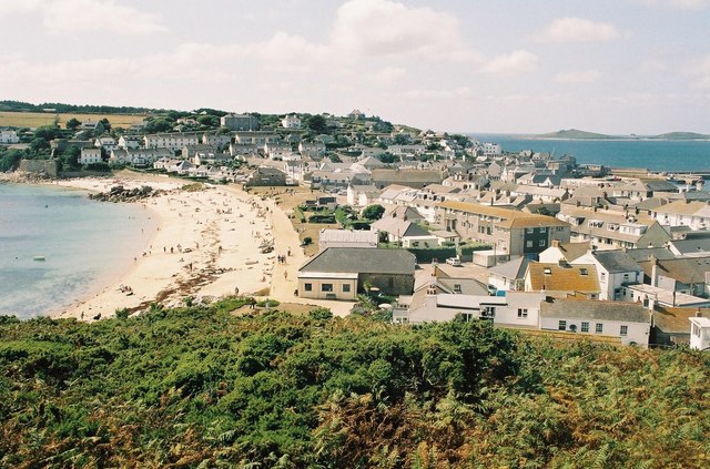
Rat Island, located off the coast of Cornwall, England, is a small uninhabited island with a rich history and unique natural features. Also known as St. Michael's Mount, this island is situated approximately 500 meters from the mainland and covers an area of around 0.23 hectares. The island is accessible during low tide via a causeway, but becomes completely cut off from the mainland during high tide, adding to its allure.

Rat Island gets its name from the abundance of rats that once inhabited the island. However, efforts have been made to eradicate the rat population, restoring the natural balance of the island's ecosystem. Today, it serves as a sanctuary for a variety of bird species, including gulls, cormorants, and oystercatchers.

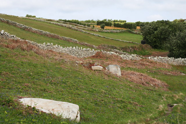
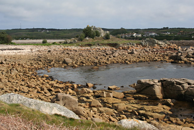
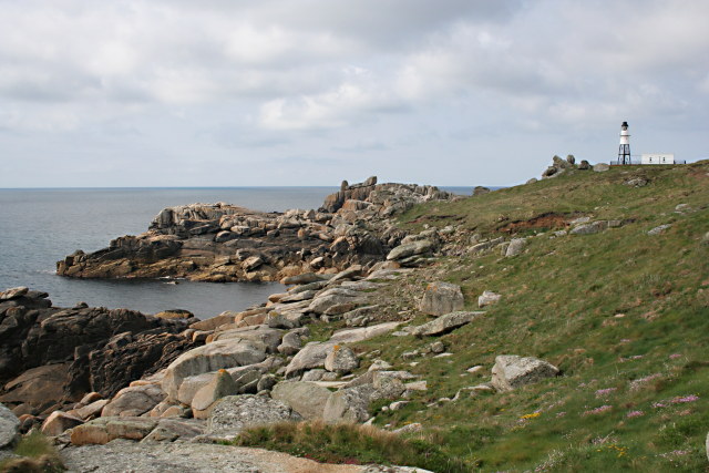
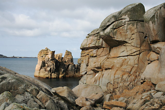
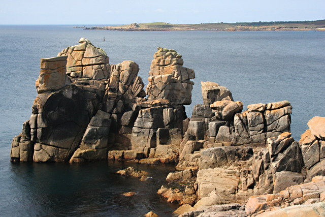
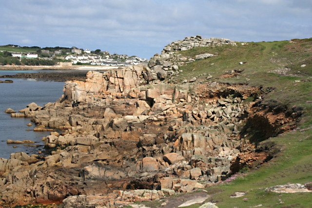
The island boasts a stunning landscape, characterized by rocky cliffs, lush vegetation, and sandy beaches. It is home to a diverse range of flora and fauna, including rare plants such as sea beet and sea kale. The surrounding waters are known for their rich marine life, making it a popular spot for snorkeling and diving enthusiasts.

The history of Rat Island is fascinating, with evidence of human habitation dating back to at least the Bronze Age. It was once home to a chapel dedicated to St. Michael, which was later converted into a private residence. Today, the island is owned by the National Trust and is open to visitors, who can explore its historic buildings, enjoy scenic walks, and soak in the natural beauty of this idyllic island.

If you have any feedback on the listing, please let us know in the comments section below.

Rat Island Images

Images are sourced within 2km of 49.917801/-6.31806 or Grid Reference SV9010. Thanks to Geograph Open Source API. All images are credited.

Pillbox entrance On Tolman Point.
Pillbox entrance
On Tolman Point.
Rock formations at Peninnis Head
Morning Point, the Garrison Looking SE to the offshore rocks Wras and (behind and smaller) Biggal; Inner Head <a href="https://www.geograph.org.uk/gridref/SV908093">SV908093</a> (part of Peninnis Head) is just visible to the far left, on the other side of Porth Cressa bay. Note the passing storm on the horizon...
Morning Point, the Garrison
Looking SE to the offshore rocks Wras and (behind and smaller) Biggal; Inner Head SV908093 (part of Peninnis Head) is just visible to the far left, on the other side of Porth Cressa bay. Note the passing storm on the horizon...
Peninnis Head Looking SSE to the lighthouse from approx. SV910097.
Peninnis Head
Looking SSE to the lighthouse from approx. SV910097.
Old Town Bay from Peninnis There is a former Battery on the island to the right of the pine tree.
Old Town Bay from Peninnis
There is a former Battery on the island to the right of the pine tree.
Tolman Point Viewed from the north on the very edge of the square; note the WW2 pillbox.
Tolman Point
Viewed from the north on the very edge of the square; note the WW2 pillbox.
Lighthouse at Peninnis Head, St. Mary's The lighthouse guides shipping passing through St. Mary's Sound, between the islands of Agnes and St. Mary's.  The lattice-work construction reduces its wind resistance.
Lighthouse at Peninnis Head, St. Mary's
The lighthouse guides shipping passing through St. Mary's Sound, between the islands of Agnes and St. Mary's. The lattice-work construction reduces its wind resistance.
St. Mary’s: Peninnis Point Viewed from the ferry from Penzance shortly before arrival on the island.
St. Mary’s: Peninnis Point
Viewed from the ferry from Penzance shortly before arrival on the island.
Photographing the Rock Labyrinth The area between the lighthouse and the Outer Head is appropriately known as the Rock Labyrinth. In younger (and slimmer) days we would explore this fantastic maze of huge granite rocks.
Photographing the Rock Labyrinth
The area between the lighthouse and the Outer Head is appropriately known as the Rock Labyrinth. In younger (and slimmer) days we would explore this fantastic maze of huge granite rocks.
Carn Leh, St. Mary's, Scilly Isles
Footpath on Peninnis Head, St. Mary's, Scilly Isles
Granite Stone Walls Granite is pretty much the only rock there is on the Scillies and there's plenty of it, so it makes sense to build your field walls out of it.
Granite Stone Walls
Granite is pretty much the only rock there is on the Scillies and there's plenty of it, so it makes sense to build your field walls out of it.
Fields on the eastern side of Peninnis The field at the bottom of the hill on the right is being used for bulb growing, the others look as though they have been left to grass.
Fields on the eastern side of Peninnis
The field at the bottom of the hill on the right is being used for bulb growing, the others look as though they have been left to grass.
Carn Leh Cove The headland of Carn Leh separates this small cove from the larger Old Town Bay.
Carn Leh Cove
The headland of Carn Leh separates this small cove from the larger Old Town Bay.
Peninnis Head Looking towards the Outer Head and the Lighthouse.
Peninnis Head
Looking towards the Outer Head and the Lighthouse.
Rock Formations on Inner Head Around Peninnis Head the granite rock has been worn to fantastic shapes by the waves and weather.
Rock Formations on Inner Head
Around Peninnis Head the granite rock has been worn to fantastic shapes by the waves and weather.
Rocky Promontory on Inner Head In the background is the island of Gugh.
Rocky Promontory on Inner Head
In the background is the island of Gugh.
The Foreshore North of Inner Head Lots of pink granite exposed on the foreshore at low tide.
The Foreshore North of Inner Head
Lots of pink granite exposed on the foreshore at low tide.
Show me another place!

Rat Island is located at Grid Ref: SV9010 (Lat: 49.917801, Lng: -6.31806)

Division: Isles of Scilly

Unitary Authority: Isles of Scilly

Police Authority: Devon and Cornwall

What 3 Words

///trespass.niece.coasted. Near St Mary's, Isles of Scilly

Related Wikis

Tregarthen's Hotel

Tregarthen's Hotel is a hotel in Hugh Town on St Mary's in the Isles of Scilly. Tregarthen's was the very first hotel to be established on the Isles of...

Star Castle, Isles of Scilly

Star Castle is a fortress on St Mary's, Isles of Scilly, built in 1593 by Robert Adams, Surveyor of the Royal Works (d.1595) and Francis Godolphin, Captain...

Wesleyan Methodist Church, Hugh Town

Wesleyan Methodist Church, Hugh Town, Isles of Scilly was a Wesleyan Methodist church in Hugh Town, Isles of Scilly from 1790. It is currently Grade II...

Hugh Town

Hugh Town (Cornish: Treworenys or Tre Huw) is the largest settlement on the Isles of Scilly and its administrative centre. The town is situated on the...

Nearby Amenities

Located within 500m of 49.917801,-6.31806
Source: PGS
Lat/Long: 49.915664/-6.3138986
Source: PGS
Lat/Long: 49.9155163/-6.3153081
Source: PGS
Lat/Long: 49.9157029/-6.3167873
Source: PGS
Lat/Long: 49.9162752/-6.3121096
Source: PGS
Lat/Long: 49.9160949/-6.3123965
Source: PGS
Lat/Long: 49.9168025/-6.3115302
Source: PGS
Lat/Long: 49.9168208/-6.3114977
Home Hardware
Shop: hardware
Source: extrapolation
Lat/Long: 49.9144844/-6.3167752
Steamship Company
Information: office
Source: extrapolation
Tourism: information
Lat/Long: 49.9148227/-6.3164465
Source: PGS
Lat/Long: 49.9136551/-6.3161991
Barrier: toll_booth
Lat/Long: 49.9178587/-6.3171371
R. Douglas
Addr City: Hugh Town
Addr Postcode: TR21 0HY
Addr Street: The Bank
Shop: chemist
Source: survey
Lat/Long: 49.9158712/-6.3178841
Mumford
Loc Name: The Papershop
Shop: kiosk
Source: extrapolation
Lat/Long: 49.9146345/-6.3163815
Rat Island
Place: locality
Lat/Long: 49.9177279/-6.3179072
49 Degrees
Shop: clothes
Source: extrapolation
Lat/Long: 49.9146873/-6.3161935
Isles of Scilly
Name Da: Scillyøerne
Name De: Scilly-Inseln
Name En: Isles of Scilly
Name Eo: Insuloj Scilly
Name Es: Islas Sorlingas
Name Fr: Îles Sorlingues
Name It: Isole Sorlinghe
Name Kw: Ynysek Syllan
Name Nl: Scilly-eilanden
Name Nn: Scillyøyane
Name No: Syllingene
Name Pt: Ilhas Sorlingas
Name Ro: Insulele Scilly
Name Sv: Scillyöarna
Place: archipelago
Lat/Long: 49.9189993/-6.3140034
Cafe
Woodcock & Mumford
Internet Access: yes
Internet Access Fee: no
Opening Hours: Mo-Sa 09:00-17:00
Outdoor Seating: no
Lat/Long: 49.9145388/-6.3163005
Seasalt
Brand: Seasalt
Brand Wikidata: Q107344382
Shop: clothes
Source: extrapolation
Lat/Long: 49.9144781/-6.3164697
Hugh Town
Ele: 2
Is In Island: St. Mary's
Name Br: Tre Huw
Name Kw: Tre Huw
Place: town
Population: 1100
Source Name Br: same as name
Wikidata: Q917474
Wikipedia: en:Hugh Town
Lat/Long: 49.9145586/-6.3153609
Telephone
Booth: KX100
Covered: booth
Source: extrapolation
Lat/Long: 49.9145794/-6.3151943
Restaurant
Mr B's Steak & Burger
Cuisine: burger
Lat/Long: 49.9147416/-6.3160745
Telephone
Booth: KX100
Check Date: 2022-10-28
Covered: booth
Phone: +44 1720 422027
Lat/Long: 49.9155841/-6.3179863
Barrier: bollard
Lat/Long: 49.9146643/-6.3158855
Barrier: bollard
Lat/Long: 49.9148184/-6.316369
Fast Food
The Galley
Cuisine: fish_and_chips
Lat/Long: 49.9145541/-6.3157019
Toilets
Fee: no
Wheelchair: yes
Lat/Long: 49.913991/-6.3148438
Barrier: bollard
Lat/Long: 49.9141188/-6.3147444
Saint Mary's Bike Hire
Addr Postcode: TR21 0PT
Shop: bicycle
Website: http://www.stmarybikehire.co.uk/
Lat/Long: 49.9151023/-6.3130773
calico jack
Shop: gift
Lat/Long: 49.9157896/-6.3179903
Crossing
Crossing Ref: zebra
Lat/Long: 49.9179303/-6.3172547
The Foredeck
Shop: clothes
Lat/Long: 49.9144733/-6.3158393
Pub
Atlantic Inn
Lat/Long: 49.9152692/-6.3171615
Island T-shirt Company
Shop: clothes
Lat/Long: 49.9145422/-6.3159255
Gibson Kyne
Shop: books
Lat/Long: 49.9144835/-6.316578
Seamark Light 1 Character: Fl
Seamark Light 1 Colour: red
Seamark Light 1 Height: 5
Seamark Light 1 Period: 2
Seamark Light 1 Range: 4
Seamark Light 1 Sector End: 100
Seamark Light 1 Sector Start: 70
Seamark Light 2 Character: Fl
Seamark Light 2 Colour: white
Seamark Light 2 Height: 5
Seamark Light 2 Period: 2
Seamark Light 2 Range: 4
Seamark Light 2 Sector End: 130
Seamark Light 2 Sector Start: 100
Seamark Light 3 Character: Fl
Seamark Light 3 Colour: green
Seamark Light 3 Height: 5
Seamark Light 3 Period: 2
Seamark Light 3 Range: 4
Seamark Light 3 Sector End: 70
Seamark Light 3 Sector Start: 130
Seamark Light Reference: A 0008
Seamark Type: light_minor
Source: US NGA Pub. 114. 2011-05-26.
Lat/Long: 49.9184667/-6.3164667
Ferry Terminal
Ferry: yes
Public Transport: station
Lat/Long: 49.9183008/-6.3165345
Rechabite Slip
Leisure: slipway
Lat/Long: 49.9154469/-6.3131689
Carn Thomas
Natural: peak
Source: Bing
Lat/Long: 49.9166957/-6.3113509
Atlantic Hotel
Tourism: hotel
Wikidata: Q26433987
Lat/Long: 49.9153901/-6.317258
Source: PGS
Lat/Long: 49.9162909/-6.3177019
Bank
Lloyds Bank
Addr Country: GB
Addr Street: Hugh Street
Atm: yes
Brand: Lloyds Bank
Brand Wikidata: Q1152847
Brand Wikipedia: en:Lloyds Bank
Contact Website: https://branches.lloydsbank.com/st-mary's/hugh-street
Wikidata: Q26433985
Lat/Long: 49.9151649/-6.3173978
Leisure: swimming_pool
Sport: swimming
Lat/Long: 49.9144558/-6.3211981
St Mary's Pool
Natural: bay
Lat/Long: 49.918383/-6.3136839
Westford House B&B
Addr City: Hugh Town
Addr Housename: Westford House
Addr Postcode: TR21 0JT
Addr Street: Church Street
Contact Email: enquiry@westfordhouse.com
Contact Website: http://www.westfordhouse.com/
Operator: Joanna Holwill
Phone: +44 1720 422510
Smoking: no
Tourism: hotel
Lat/Long: 49.9144977/-6.3134509
Recycling
Recycling Cans: yes
Recycling Clothes: yes
Recycling Electrical Appliances: no
Recycling Glass: yes
Recycling Glass Bottles: yes
Recycling Scrap Metal: no
Recycling Small Appliances: no
Recycling Type: container
Lat/Long: 49.9142715/-6.315192
Leisure: slipway
Lat/Long: 49.9156101/-6.3171353
Leisure: slipway
Lat/Long: 49.9161627/-6.3178435
St Mary's Harbour
Leisure: marina
Seamark Harbour Category: marina
Seamark Type: harbour
Lat/Long: 49.9167813/-6.315077
Leisure: slipway
Lat/Long: 49.9136748/-6.3162278
Co-op Food
Addr City: Hugh Town
Addr Housenumber: 4
Addr Postcode: TR21 0LL
Addr Street: Hugh Street
Brand: Co-op Food
Brand Wikidata: Q3277439
Brand Wikipedia: en:Co-op Food
Check Date Opening Hours: 2022-08-11
Opening Hours: Mo-Sa 08:00-22:00; Su 10:00-16:00
Operator: The Co-operative Group
Operator Wikidata: Q117202
Shop: supermarket
Source: GEOLYTIX Retail Points
Website: https://www.coop.co.uk/store-finder/TR21-0LL/4-hugh-street
Lat/Long: 49.9149846/-6.3167071
Griffin
Shop: butcher
Lat/Long: 49.9144843/-6.316684
Bar
Dungeon Bar
Lat/Long: 49.915453/-6.3210047
Stone Shop
Shop: jewelry
Lat/Long: 49.9148306/-6.3144691
Historic: memorial
Lat/Long: 49.9142425/-6.3187962
Tourism: viewpoint
Lat/Long: 49.9143284/-6.3187784
The Wheelhouse
Tourism: guest_house
Lat/Long: 49.9140542/-6.3160982
Parking
Parking: surface
Lat/Long: 49.9141662/-6.3154926
Bus Stop
Island Rover Mini-Bus Tours
Bus: yes
Operator: Island Rover
Public Transport: platform
Lat/Long: 49.9150392/-6.31372
Rechabite Boat Park
Leisure: marina
Operator: Council of the Isles of Scilly
Seamark Harbour Category: marina
Seamark Type: harbour
Lat/Long: 49.9153256/-6.3132516
Post Office
St Mary's Post Office
Addr City: Hugh Town
Addr Postcode: TR21 0LR
Addr Street: Hugh Street
Brand: Post Office
Brand Wikidata: Q1783168
Opening Hours: Mo-Fr 08:15-15:00; Sa 08:15-12:15
Ref Pol Id: 13693
Source: pol_branch_list_2022‑05‑27
Website: https://www.postoffice.co.uk/branch-finder/3565556/st-marys
Wikidata: Q26579865
Lat/Long: 49.9150427/-6.3171005
Mount Hollis
Place: locality
Lat/Long: 49.9152426/-6.3181367
Cafe
Kavorna
Lat/Long: 49.9150942/-6.3172733
Bordeaux
Shop: kiosk
Lat/Long: 49.9146305/-6.3156696
Bicycle Parking
Bicycle Parking: stands
Capacity: 20
Covered: no
Fee: no
Lat/Long: 49.914581/-6.3152307
Cut Loose
Shop: hairdresser
Lat/Long: 49.915023/-6.3133165
Fast Food
illy
Cuisine: sandwich
Lat/Long: 49.91507/-6.3131748
Recycling
Recycling Glass Bottles: yes
Recycling Type: container
Lat/Long: 49.9152661/-6.3130952
Adam and Eve
Shop: hairdresser
Lat/Long: 49.9150164/-6.3161199
Recycling
Recycling Glass Bottles: yes
Recycling Type: container
Lat/Long: 49.9154981/-6.3173483
Shop: gift
Lat/Long: 49.9151325/-6.3129802
Tanglewood
Shop: convenience
Lat/Long: 49.9149616/-6.3171629
Bench
Lat/Long: 49.9134969/-6.3174518
Restaurant
The Pilots Gig
Lat/Long: 49.915892/-6.318042
Parking
Parking: surface
Lat/Long: 49.9159809/-6.3184231
Toilets
Lat/Long: 49.9177118/-6.3172307
Pub
Scillonian Club
Lat/Long: 49.9149696/-6.3144669
Fast Food
Lat/Long: 49.9142512/-6.3152843
Shelter
Waiting Room
Lat/Long: 49.9175018/-6.3173196
Cafe
Lat/Long: 49.9176051/-6.3172747
Seamark Small Craft Facility Category: fuel_station
Seamark Type: small_craft_facility
Waterway: fuel
Lat/Long: 49.9172073/-6.317278
Bench
Backrest: no
Lat/Long: 49.9139688/-6.3153175
Cafe
Tea by the Sea
Lat/Long: 49.9139359/-6.3161507
Bench
Backrest: yes
Lat/Long: 49.9155372/-6.3207527
Leisure: picnic_table
Lat/Long: 49.9152214/-6.3134577
Information: board
Tourism: information
Lat/Long: 49.9160029/-6.3231427
Town Notice Board
Information: board
Operator: Council of the Isles of Scilly
Tourism: information
Lat/Long: 49.9144121/-6.3151403
King Charles' Battery
Historic: fort
Lat/Long: 49.9158911/-6.3235238
Barrier: sally_port
Lat/Long: 49.9137108/-6.3185789
Direction: 175
Generator Method: photovoltaic
Generator Output Electricity: yes
Generator Solar Modules: 14
Generator Source: solar
Generator Type: solar_photovoltaic_panel
Location: roof
Power: generator
Lat/Long: 49.9146244/-6.3185538
Generator Method: photovoltaic
Generator Output Electricity: yes
Generator Source: solar
Generator Type: solar_photovoltaic_panel
Location: roof
Power: generator
Lat/Long: 49.9148096/-6.3178517
Generator Method: photovoltaic
Generator Output Electricity: yes
Generator Source: solar
Generator Type: solar_photovoltaic_panel
Location: roof
Power: generator
Lat/Long: 49.914558/-6.3182541
Generator Method: photovoltaic
Generator Output Electricity: yes
Generator Source: solar
Generator Type: solar_photovoltaic_panel
Location: roof
Power: generator
Lat/Long: 49.9145605/-6.3181984
Generator Method: photovoltaic
Generator Output Electricity: yes
Generator Source: solar
Generator Type: solar_photovoltaic_panel
Location: roof
Power: generator
Lat/Long: 49.9144894/-6.318244
Generator Method: photovoltaic
Generator Output Electricity: yes
Generator Source: solar
Generator Type: solar_photovoltaic_panel
Location: roof
Power: generator
Lat/Long: 49.9144928/-6.3181857
Generator Method: photovoltaic
Generator Output Electricity: yes
Generator Source: solar
Generator Type: solar_photovoltaic_panel
Location: roof
Power: generator
Lat/Long: 49.9142933/-6.3182253
Generator Method: photovoltaic
Generator Output Electricity: yes
Generator Source: solar
Generator Type: solar_photovoltaic_panel
Location: roof
Power: generator
Lat/Long: 49.9142959/-6.318173
Generator Method: photovoltaic
Generator Output Electricity: yes
Generator Source: solar
Generator Type: solar_photovoltaic_panel
Location: roof
Power: generator
Lat/Long: 49.9141671/-6.3181925
Generator Method: photovoltaic
Generator Output Electricity: yes
Generator Source: solar
Generator Type: solar_photovoltaic_panel
Location: roof
Power: generator
Lat/Long: 49.9141709/-6.3181375
Generator Method: photovoltaic
Generator Output Electricity: yes
Generator Source: solar
Generator Type: solar_photovoltaic_panel
Location: roof
Power: generator
Lat/Long: 49.9140936/-6.3181801
Generator Method: photovoltaic
Generator Output Electricity: yes
Generator Source: solar
Generator Type: solar_photovoltaic_panel
Location: roof
Power: generator
Lat/Long: 49.9140972/-6.3181279
Generator Method: photovoltaic
Generator Output Electricity: yes
Generator Source: solar
Generator Type: solar_photovoltaic_panel
Location: roof
Power: generator
Lat/Long: 49.9139245/-6.3181273
Generator Method: photovoltaic
Generator Output Electricity: yes
Generator Source: solar
Generator Type: solar_photovoltaic_panel
Location: roof
Power: generator
Lat/Long: 49.9139371/-6.3180657
Generator Method: photovoltaic
Generator Output Electricity: yes
Generator Source: solar
Generator Type: solar_photovoltaic_panel
Location: roof
Power: generator
Lat/Long: 49.9138412/-6.3180764
Generator Method: photovoltaic
Generator Output Electricity: yes
Generator Source: solar
Generator Type: solar_photovoltaic_panel
Location: roof
Power: generator
Lat/Long: 49.9138572/-6.318004
Generator Method: photovoltaic
Generator Output Electricity: yes
Generator Source: solar
Generator Type: solar_photovoltaic_panel
Location: roof
Power: generator
Lat/Long: 49.9139729/-6.3178503
Generator Method: photovoltaic
Generator Output Electricity: yes
Generator Source: solar
Generator Type: solar_photovoltaic_panel
Location: roof
Power: generator
Lat/Long: 49.9139815/-6.3177857
Generator Method: photovoltaic
Generator Output Electricity: yes
Generator Source: solar
Generator Type: solar_photovoltaic_panel
Location: roof
Power: generator
Lat/Long: 49.9141297/-6.3176861
Generator Method: photovoltaic
Generator Output Electricity: yes
Generator Source: solar
Generator Type: solar_photovoltaic_panel
Location: roof
Power: generator
Lat/Long: 49.9141184/-6.3179436
Generator Method: photovoltaic
Generator Output Electricity: yes
Generator Source: solar
Generator Type: solar_photovoltaic_panel
Location: roof
Power: generator
Lat/Long: 49.9141443/-6.3178926
Generator Method: photovoltaic
Generator Output Electricity: yes
Generator Source: solar
Generator Type: solar_photovoltaic_panel
Location: roof
Power: generator
Lat/Long: 49.9136122/-6.3178786
Generator Method: photovoltaic
Generator Output Electricity: yes
Generator Source: solar
Generator Type: solar_photovoltaic_panel
Location: roof
Power: generator
Lat/Long: 49.9136201/-6.3178285
Generator Method: photovoltaic
Generator Output Electricity: yes
Generator Source: solar
Generator Type: solar_photovoltaic_panel
Location: roof
Power: generator
Lat/Long: 49.9134786/-6.3178362
Generator Method: photovoltaic
Generator Output Electricity: yes
Generator Source: solar
Generator Type: solar_photovoltaic_panel
Location: roof
Power: generator
Lat/Long: 49.9134863/-6.3177822
Generator Method: photovoltaic
Generator Output Electricity: yes
Generator Source: solar
Generator Type: solar_photovoltaic_panel
Location: roof
Power: generator
Lat/Long: 49.9133507/-6.3178169
Generator Method: photovoltaic
Generator Output Electricity: yes
Generator Source: solar
Generator Type: solar_photovoltaic_panel
Location: roof
Power: generator
Lat/Long: 49.9133489/-6.3177551
Generator Method: photovoltaic
Generator Output Electricity: yes
Generator Source: solar
Generator Type: solar_photovoltaic_panel
Location: roof
Power: generator
Lat/Long: 49.9142092/-6.3149516
Generator Method: photovoltaic
Generator Output Electricity: yes
Generator Source: solar
Generator Type: solar_photovoltaic_panel
Location: roof
Power: generator
Lat/Long: 49.9142144/-6.3148416
Generator Method: photovoltaic
Generator Output Electricity: yes
Generator Source: solar
Generator Type: solar_photovoltaic_panel
Location: roof
Power: generator
Lat/Long: 49.9148587/-6.3128655
Generator Method: photovoltaic
Generator Output Electricity: yes
Generator Source: solar
Generator Type: solar_photovoltaic_panel
Location: roof
Power: generator
Lat/Long: 49.9148699/-6.3136863
Generator Method: photovoltaic
Generator Output Electricity: yes
Generator Source: solar
Generator Type: solar_photovoltaic_panel
Location: roof
Power: generator
Lat/Long: 49.9148638/-6.3137177
Generator Method: photovoltaic
Generator Output Electricity: yes
Generator Source: solar
Generator Type: solar_photovoltaic_panel
Location: roof
Power: generator
Lat/Long: 49.9144155/-6.3172868
Generator Method: photovoltaic
Generator Output Electricity: yes
Generator Source: solar
Generator Type: solar_photovoltaic_panel
Location: roof
Power: generator
Lat/Long: 49.9143857/-6.3170803
Generator Method: photovoltaic
Generator Output Electricity: yes
Generator Source: solar
Generator Type: solar_photovoltaic_panel
Location: roof
Power: generator
Lat/Long: 49.9147667/-6.3179097
Generator Method: photovoltaic
Generator Output Electricity: yes
Generator Source: solar
Generator Type: solar_photovoltaic_panel
Location: roof
Power: generator
Lat/Long: 49.9140515/-6.318401
Generator Method: photovoltaic
Generator Output Electricity: yes
Generator Source: solar
Generator Type: solar_photovoltaic_panel
Location: roof
Power: generator
Lat/Long: 49.9140435/-6.318447
Generator Method: photovoltaic
Generator Output Electricity: yes
Generator Source: solar
Generator Type: solar_photovoltaic_panel
Location: roof
Power: generator
Lat/Long: 49.9139642/-6.3184138
Generator Method: photovoltaic
Generator Output Electricity: yes
Generator Source: solar
Generator Type: solar_photovoltaic_panel
Location: roof
Power: generator
Lat/Long: 49.9139714/-6.3183721
Generator Method: photovoltaic
Generator Output Electricity: yes
Generator Source: solar
Generator Type: solar_photovoltaic_panel
Location: roof
Power: generator
Lat/Long: 49.9138442/-6.3183527
Generator Method: photovoltaic
Generator Output Electricity: yes
Generator Source: solar
Generator Type: solar_photovoltaic_panel
Location: roof
Power: generator
Lat/Long: 49.9137868/-6.3183219
Generator Method: photovoltaic
Generator Output Electricity: yes
Generator Source: solar
Generator Type: solar_photovoltaic_panel
Location: roof
Power: generator
Lat/Long: 49.9138529/-6.3183098
Generator Method: photovoltaic
Generator Output Electricity: yes
Generator Source: solar
Generator Type: solar_photovoltaic_panel
Location: roof
Power: generator
Lat/Long: 49.913806/-6.3182827
Generator Method: photovoltaic
Generator Output Electricity: yes
Generator Source: solar
Generator Type: solar_photovoltaic_panel
Location: roof
Power: generator
Lat/Long: 49.9137077/-6.3182795
Generator Method: photovoltaic
Generator Output Electricity: yes
Generator Source: solar
Generator Type: solar_photovoltaic_panel
Location: roof
Power: generator
Lat/Long: 49.9137184/-6.3182357
Generator Method: photovoltaic
Generator Output Electricity: yes
Generator Source: solar
Generator Type: solar_photovoltaic_panel
Location: roof
Power: generator
Lat/Long: 49.9136502/-6.3182487
Generator Method: photovoltaic
Generator Output Electricity: yes
Generator Source: solar
Generator Type: solar_photovoltaic_panel
Location: roof
Power: generator
Lat/Long: 49.9136592/-6.3182031
Generator Method: photovoltaic
Generator Output Electricity: yes
Generator Source: solar
Generator Type: solar_photovoltaic_panel
Location: roof
Power: generator
Lat/Long: 49.9141246/-6.3178018
Seamark Mooring Category: buoy
Seamark Mooring Colour: orange
Seamark Name: RNLI
Seamark Source: Bing
Seamark Type: mooring
Lat/Long: 49.9192493/-6.3146174
The Whiteheads
Water Rescue
Emergency: water_rescue
Operator: Royal National Lifeboat Institution
Operator Short: RNLI
Operator Wikidata: Q2166873
Ref: 17-11
Seamark Name: The Whiteheads
Seamark Radio Station Category: ais
Seamark Radio Station Mmsi: 232003049
Seamark Rescue Station Category: lifeboat_on_mooring
Seamark Source: Bing; https://rnli.org/find-my-nearest
Seamark Type: rescue_station
Website: https://rnli.org/find-my-nearest/lifeboat-stations/st-marys-lifeboat-station/our-lifeboats-st-marys-lifeboat-station
Lat/Long: 49.91912/-6.314725
Post Box
Brand: Royal Mail
Brand Wikidata: Q638098
Brand Wikipedia: en:Royal Mail
Collection Times: Mo-Fr 13:00; Sa 08:00; Su off
Operator: Royal Mail
Operator Wikidata: Q638098
Post Box Mounting: building
Post Box Type: lamp
Ref: TR21 71
Royal Cypher: EIIR
Royal Cypher Wikidata: Q33102113
Source: aerial imagery;streetlevel imagery
Lat/Long: 49.9178044/-6.3171743
Newman Battery
Place: locality
Lat/Long: 49.91693/-6.3214557
Barrier: entrance
Lat/Long: 49.9154283/-6.3193762
Generator Method: photovoltaic
Generator Output Electricity: yes
Generator Source: solar
Generator Type: solar_photovoltaic_panel
Location: roof
Power: generator
Lat/Long: 49.9144615/-6.3139475
Leisure: picnic_table
Lat/Long: 49.9152378/-6.31369
Leisure: picnic_table
Lat/Long: 49.915202/-6.3138382
Leisure: picnic_table
Lat/Long: 49.9151649/-6.3137081
Leisure: picnic_table
Lat/Long: 49.9152642/-6.3135485
Leisure: picnic_table
Lat/Long: 49.9151934/-6.3135713
Seamark Light Category: vertical
Seamark Light Character: F
Seamark Light Colour: green
Lat/Long: 49.9186371/-6.3162281
Seamark Buoy Lateral Category: starboard
Seamark Buoy Lateral Colour: green
Seamark Buoy Lateral Shape: conical
Seamark Buoy Lateral System: iala-a
Seamark Light Character: Fl
Seamark Light Colour: green
Seamark Light Group: 2
Seamark Light Period: 5
Seamark Name: Newman
Seamark Type: buoy_lateral
Lat/Long: 49.9190395/-6.3212988
Seamark Buoy Lateral Category: port
Seamark Buoy Lateral Colour: red
Seamark Buoy Lateral Shape: can
Seamark Buoy Lateral System: iala-a
Seamark Light Character: Fl
Seamark Light Colour: red
Seamark Light Group: 4
Seamark Light Period: 5
Seamark Name: Bacon Buoy
Seamark Type: buoy_lateral
Lat/Long: 49.9203296/-6.3207436
The data included in this document is from www.openstreetmap.org. The data is made available under ODbL.

Have you been to Rat Island?

Leave your review of Rat Island below (or comments, questions and feedback).