Great Smith

Island in Cornwall

England

Great Smith

Table laid-out for the St Agnes Coronation Street Party The “street” in this case is Old Lane.  No traffic order is required to close the road here! The Island Hall on the left had tables groaning under the weight of many cakes and other treats.
Table laid-out for the St Agnes Coronation Street Party Credit: David Lally

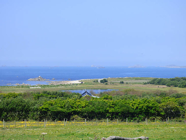
Great Smith, Cornwall is a small island located off the southwestern coast of England, in the county of Cornwall. It is part of the Isles of Scilly archipelago, situated approximately 28 miles off the mainland. With a land area of just 0.14 square miles, Great Smith is one of the smallest inhabited islands in the region.

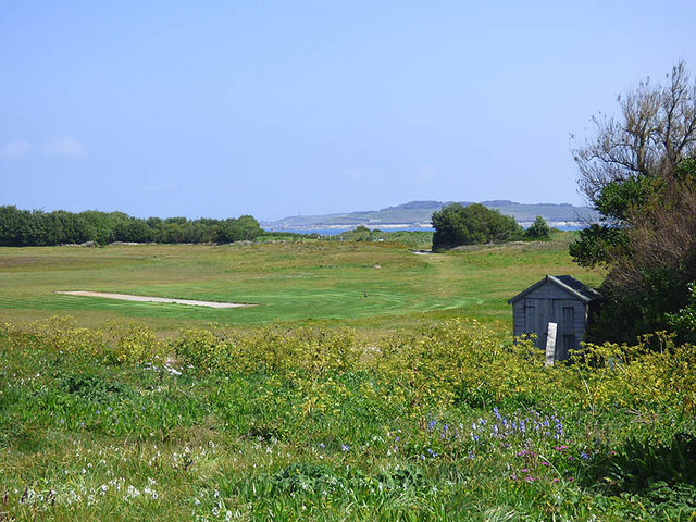
The island is predominantly flat and features sandy beaches, rocky outcrops, and lush green vegetation. The climate in Great Smith is mild, influenced by the warm Gulf Stream, which allows for a diverse range of flora and fauna to thrive. The island is home to a variety of bird species, including puffins, cormorants, and gulls, making it a haven for birdwatchers.

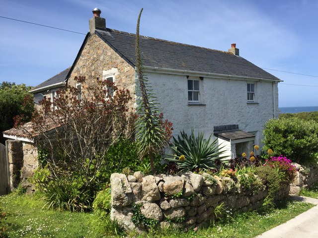
The main settlement on Great Smith consists of a small cluster of houses and cottages, providing accommodation for the island's population. The community is closely knit, and residents mainly rely on fishing, farming, and tourism for their livelihoods. Visitors to Great Smith can enjoy peaceful walks along the picturesque coastline, explore the island's rich marine life through snorkeling or diving, or simply relax on its pristine beaches.

Access to Great Smith is primarily by boat or helicopter, with regular services available from the nearby islands of St. Mary's and Tresco. The island is a popular destination for day trippers and nature enthusiasts seeking a tranquil escape from the bustling mainland. With its stunning natural beauty, Great Smith offers visitors an intimate and idyllic setting in the heart of the Isles of Scilly.

If you have any feedback on the listing, please let us know in the comments section below.

Great Smith Images

Images are sourced within 2km of 49.902036/-6.3626799 or Grid Reference SV8609. Thanks to Geograph Open Source API. All images are credited.

Table laid-out for the St Agnes Coronation Street Party The “street” in this case is Old Lane.  No traffic order is required to close the road here! The Island Hall on the left had tables groaning under the weight of many cakes and other treats.
Table laid-out for the St Agnes Coronation Street Party
The “street” in this case is Old Lane. No traffic order is required to close the road here! The Island Hall on the left had tables groaning under the weight of many cakes and other treats.
A stile to Browarth A tad more conventional than 15 years ago <a href="https://www.geograph.org.uk/photo/827432">SV8708 : Crate Based Stile</a>.
A stile to Browarth
A tad more conventional than 15 years ago SV8708 : Crate Based Stile.
Two post-medieval quays These quays are believed to have been built to land coal for the St Agnes lighthouse.

For more details see the details on their Historic England listing:
List Entry Number:1016512. <span class="nowrap"><a title="https://historicengland.org.uk/listing/the-list/list-entry/1016512?section=official-list-entry" rel="nofollow ugc noopener" href="https://historicengland.org.uk/listing/the-list/list-entry/1016512?section=official-list-entry">Link</a><img style="margin-left:2px;" alt="External link" title="External link - shift click to open in new window" src="https://s1.geograph.org.uk/img/external.png" width="10" height="10"/></span>

The named quay “Uncle Tom’s Quay” is the more eroded of the two but can still be discerned to the right of the picture surmounted by a herring gull.
Two post-medieval quays
These quays are believed to have been built to land coal for the St Agnes lighthouse. For more details see the details on their Historic England listing: List Entry Number:1016512. LinkExternal link The named quay “Uncle Tom’s Quay” is the more eroded of the two but can still be discerned to the right of the picture surmounted by a herring gull.
Refloating Elvera This small launch is probably about 90 years old now.

It's spent the winter in a nearby field undergoing "months of work" according to its owner (on the right of the picture standing on the slipway.)

I expressed surprise that they had towed it down at such a low tide "You are going to let the tide float her?" "Yes, she's full of leaks".
Refloating Elvera
This small launch is probably about 90 years old now. It's spent the winter in a nearby field undergoing "months of work" according to its owner (on the right of the picture standing on the slipway.) I expressed surprise that they had towed it down at such a low tide "You are going to let the tide float her?" "Yes, she's full of leaks".
The St Agnes Lighthouse and attached house From Old lane.

The lighthouse is both a Grade II* listed building List Entry Number:1328835 <span class="nowrap"><a title="https://historicengland.org.uk/listing/the-list/list-entry/1328835" rel="nofollow ugc noopener" href="https://historicengland.org.uk/listing/the-list/list-entry/1328835">Link</a><img style="margin-left:2px;" alt="External link" title="External link - shift click to open in new window" src="https://s1.geograph.org.uk/img/external.png" width="10" height="10"/></span>

and a Scheduled Monument List Entry Number:1014999 <span class="nowrap"><a title="https://historicengland.org.uk/listing/the-list/list-entry/1014999?section=official-list-entry" rel="nofollow ugc noopener" href="https://historicengland.org.uk/listing/the-list/list-entry/1014999?section=official-list-entry">Link</a><img style="margin-left:2px;" alt="External link" title="External link - shift click to open in new window" src="https://s1.geograph.org.uk/img/external.png" width="10" height="10"/></span>

The house is Grade II List Entry Number:1218288 <span class="nowrap"><a title="https://historicengland.org.uk/listing/the-list/list-entry/1218288" rel="nofollow ugc noopener" href="https://historicengland.org.uk/listing/the-list/list-entry/1218288">Link</a><img style="margin-left:2px;" alt="External link" title="External link - shift click to open in new window" src="https://s1.geograph.org.uk/img/external.png" width="10" height="10"/></span>
The St Agnes Lighthouse and attached house
From Old lane. The lighthouse is both a Grade II* listed building List Entry Number:1328835 LinkExternal link and a Scheduled Monument List Entry Number:1014999 LinkExternal link The house is Grade II List Entry Number:1218288 LinkExternal link
Aboard The Sapphire It was great to have this fine Association (<span class="nowrap"><a title="https://www.scillyboating.co.uk" rel="nofollow ugc noopener" href="https://www.scillyboating.co.uk">Link</a><img style="margin-left:2px;" alt="External link" title="External link - shift click to open in new window" src="https://s1.geograph.org.uk/img/external.png" width="10" height="10"/></span> ) open boat to ourselves.  It had just dropped off a full load of day-trippers from St Mary's on the St Agnes quay.  We "hitched" a ride back to St Mary's as the Spirit of St Agnes was out of service due to engine trouble.
Aboard The Sapphire
It was great to have this fine Association (LinkExternal link ) open boat to ourselves. It had just dropped off a full load of day-trippers from St Mary's on the St Agnes quay. We "hitched" a ride back to St Mary's as the Spirit of St Agnes was out of service due to engine trouble.
Refloating Elvera Taken a few minutes before <a href="https://www.geograph.org.uk/photo/7486422">SV8708 : Refloating Elvera</a>. This shows a family group bringing an heirloom back into use.

60 years ago this little launch would take my family (weather permitting) to Catholic Mass on St Mary's when holidaying on St Agnes . It would be sailed by the father of the man on driving the tractor and grandfather of the two men at the stern of the boat.
Refloating Elvera
Taken a few minutes before SV8708 : Refloating Elvera. This shows a family group bringing an heirloom back into use. 60 years ago this little launch would take my family (weather permitting) to Catholic Mass on St Mary's when holidaying on St Agnes . It would be sailed by the father of the man on driving the tractor and grandfather of the two men at the stern of the boat.
Refloating Elvera Taken a minute or two after <a href="https://www.geograph.org.uk/photo/7491445">SV8708 : Refloating Elvera</a>. See that for a bit of history.
Refloating Elvera
Taken a minute or two after SV8708 : Refloating Elvera. See that for a bit of history.
Old Lane A small group of isolated cottages between the lighthouse and Periglis do not merit even a Scillonian recognition as a "Town".
Old Lane
A small group of isolated cottages between the lighthouse and Periglis do not merit even a Scillonian recognition as a "Town".
Tresco will be busy today Three cruise ships in The Road today.  No doubt the most popular shore trip will be to Tesco's famous sub-tropical gardens.  As long as they keep away from St Agnes, that will be fine.

The boat heading into Perconger is the St Agnes boating's sea taxi craft "Enterprise".
Tresco will be busy today
Three cruise ships in The Road today. No doubt the most popular shore trip will be to Tesco's famous sub-tropical gardens. As long as they keep away from St Agnes, that will be fine. The boat heading into Perconger is the St Agnes boating's sea taxi craft "Enterprise".
Kate's Bakes Cake stall with honesty box and card reader.  Lovely cakes!
Kate's Bakes
Cake stall with honesty box and card reader. Lovely cakes!
Traditional woven "ink pot" lobster pots Made from tamarisk and willow harvested on the island.  And laid using oar and sail.
Traditional woven "ink pot" lobster pots
Made from tamarisk and willow harvested on the island. And laid using oar and sail.
Old Lifeboat Shed The St Agnes lifeboat shed
Old Lifeboat Shed
The St Agnes lifeboat shed
Old rails for the lifeboat trolley For the St Agnes Lifeboat
Old rails for the lifeboat trolley
For the St Agnes Lifeboat
Daymark on Burnt Island From St Agnes
Daymark on Burnt Island
From St Agnes
View of St. Agnes pool from the road to the lighthouse The strange 'daymark' visible top left of the picture
View of St. Agnes pool from the road to the lighthouse
The strange 'daymark' visible top left of the picture
St. Agnes' cricket pitch with St. Mary's in background The pitch had been mown that morning. Maybe there was a match due!
St. Agnes' cricket pitch with St. Mary's in background
The pitch had been mown that morning. Maybe there was a match due!
House on Old Lane St Agnes, Isles of Scilly
House on Old Lane
St Agnes, Isles of Scilly
Show me another place!

Great Smith is located at Grid Ref: SV8609 (Lat: 49.902036, Lng: -6.3626799)

Division: Isles of Scilly

Unitary Authority: Isles of Scilly

Police Authority: Devon and Cornwall

What 3 Words

///storms.walkway.readjust. Near St Agnes, Isles of Scilly

Related Wikis

Burnt Island, Isles of Scilly

Burnt Island is a small, uninhabited island in the Isles of Scilly, Cornwall, United Kingdom. It is covered in thrift and long grasses. and is linked to...

Annet, Isles of Scilly

Annet (Cornish: Anet, lit. 'kittiwake') is the second largest of the fifty or so uninhabited Isles of Scilly, 1 kilometre (0.62 mi) west of St Agnes with...

St Agnes Lifeboat Station, Isles of Scilly

St Agnes' Lifeboat Station was situated in St Agnes, Isles of Scilly and provided a service for the Royal National Lifeboat Institution from 1891 to 1920...

Bible Christian Chapel, St Agnes, Isles of Scilly

The Bible Christian Chapel, St Agnes was a Bible Christian chapel in St Agnes, Isles of Scilly. == History == Bible Christians arrived in St Agnes in the...

Have you been to Great Smith?

Leave your review of Great Smith below (or comments, questions and feedback).