Linley

Settlement in Shropshire

England

Linley

Church Farm, More
Church Farm, More Credit: Chris Andrews

Linley is a small village located in the county of Shropshire, England. Situated approximately 5 miles southeast of the town of Bishop's Castle, it is nestled within the scenic countryside of the Shropshire Hills Area of Outstanding Natural Beauty.

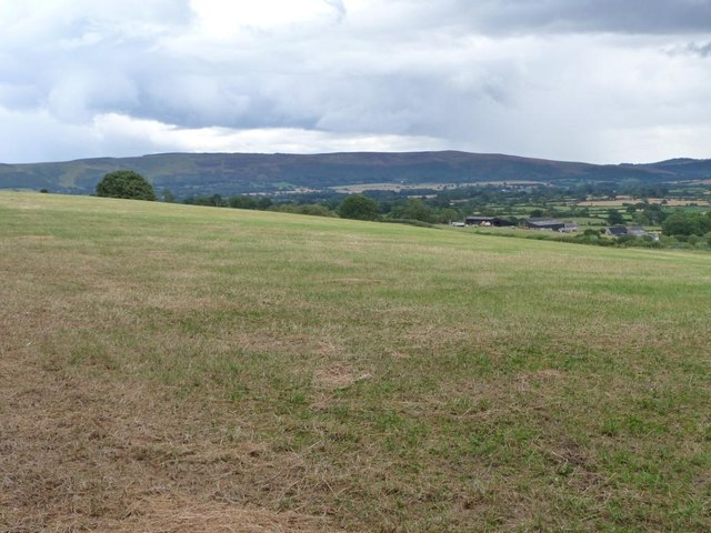
The village is known for its picturesque setting, with rolling hills, lush green fields, and charming traditional cottages dotting the landscape. It offers a tranquil retreat for those seeking a peaceful and idyllic escape from the bustling city life.

Linley is home to a tight-knit community, with a population of around 200 residents. The village boasts a close community spirit, with regular social events and gatherings held at the village hall. Additionally, there is a parish church, St. Leonard's, which dates back to the 13th century and holds regular services.

Despite its small size, Linley is well-connected to the surrounding areas. The nearby town of Bishop's Castle provides amenities such as shops, cafes, and schools, ensuring that residents have access to essential services. The village is also a popular destination for tourists and outdoor enthusiasts, thanks to its proximity to the Shropshire Hills. Visitors can enjoy hiking, cycling, and exploring the numerous walking trails that crisscross the area.

Overall, Linley is a charming and picturesque village that offers a peaceful and rural lifestyle, surrounded by the stunning natural beauty of the Shropshire countryside.

If you have any feedback on the listing, please let us know in the comments section below.

Linley Images

Images are sourced within 2km of 52.529285/-2.9591521 or Grid Reference SO3592. Thanks to Geograph Open Source API. All images are credited.

Church Farm, More
Church Farm, More
Old Beech avenue on Linley Hill This lovely section of the Shropshire Way has an avenue of Beech trees planted either side of it. The Beeches were planted by British ex-soldiers following the victory over the French in the Napoleonic Wars of the early 19th century. It was possibly a scheme whereby large numbers of ex-servicemen not engaged in the occupation of France but returned to home soil could gain 'employment' from a grateful nation keen to recognise and commemorate the victory, the men's service and provide a benefit for the landscape in terms of a new and lasting visual amenity. So these old rotting trunks are around or nearly 200 years old. Some efforts have been made to preserve the integrity of the avenue with new planting, which is good to see.
Old Beech avenue on Linley Hill
This lovely section of the Shropshire Way has an avenue of Beech trees planted either side of it. The Beeches were planted by British ex-soldiers following the victory over the French in the Napoleonic Wars of the early 19th century. It was possibly a scheme whereby large numbers of ex-servicemen not engaged in the occupation of France but returned to home soil could gain 'employment' from a grateful nation keen to recognise and commemorate the victory, the men's service and provide a benefit for the landscape in terms of a new and lasting visual amenity. So these old rotting trunks are around or nearly 200 years old. Some efforts have been made to preserve the integrity of the avenue with new planting, which is good to see.
Old Beech avenue on Linley Hill, part of the Shropshire Way A mature Beech avenue is a magnificent way to commemorate the British victory in the Napoleonic Wars, especially as ex-soldiers planted these trees, probably around 1815 or so. Over the last two centuries the avenue has suffered some losses, only to be expected with Beeches which are prone to storm damage and limb drop. In its heyday the avenue must have provided a lovely ride for mounted gentry and a pleasant walk for the foot-slogging agricultural labourers or drovers.
Old Beech avenue on Linley Hill, part of the Shropshire Way
A mature Beech avenue is a magnificent way to commemorate the British victory in the Napoleonic Wars, especially as ex-soldiers planted these trees, probably around 1815 or so. Over the last two centuries the avenue has suffered some losses, only to be expected with Beeches which are prone to storm damage and limb drop. In its heyday the avenue must have provided a lovely ride for mounted gentry and a pleasant walk for the foot-slogging agricultural labourers or drovers.
Old pond at Nurton Seemingly an old round pond has partly dried up here adjacent to the farm.
Old pond at Nurton
Seemingly an old round pond has partly dried up here adjacent to the farm.
The church and pub in Norbury Two elements close to the centre of traditional village life for many centuries in villages countrywide. Here All Saints church and the Sun Inn sit side-by-side looking out on modern society's changing values and customs and both look implacable. Or resigned.
The church and pub in Norbury
Two elements close to the centre of traditional village life for many centuries in villages countrywide. Here All Saints church and the Sun Inn sit side-by-side looking out on modern society's changing values and customs and both look implacable. Or resigned.
Lane north of Norbury, Shropshire The roofless property is called Mount Pleasant and must have suffered some sort of disaster such as a fire I expect. Always interesting to speculate; was it insured, arson, faulty wiring, a bolt of lightning?
Lane north of Norbury, Shropshire
The roofless property is called Mount Pleasant and must have suffered some sort of disaster such as a fire I expect. Always interesting to speculate; was it insured, arson, faulty wiring, a bolt of lightning?
The minor road near Greenfields
Greenfields
Greenfields
Newton Farm
Newton Farm
Track up Lindley Hill Part of the Shropshire Way [the section between Bridges and Bishop's Castle].
Track up Lindley Hill
Part of the Shropshire Way [the section between Bridges and Bishop's Castle].
Narrow lane to Cold Hill Just above the junction with the narrow lane to Rock Farm.
Narrow lane to Cold Hill
Just above the junction with the narrow lane to Rock Farm.
Arbour Lane Dropping down to Linley.
Arbour Lane
Dropping down to Linley.
Field east of Arbour Lane Dropping down the hillside towards Linley.
Field east of Arbour Lane
Dropping down the hillside towards Linley.
Hillside above Squire Hall Seen from a gate off Arbour Lane.
Hillside above Squire Hall
Seen from a gate off Arbour Lane.
Trees at the corner of a field Seen from a gate in the adjoining field.
Trees at the corner of a field
Seen from a gate in the adjoining field.
Freehold Farm, Norbury Owned by the Edwards family.
Freehold Farm, Norbury
Owned by the Edwards family.
Norbury's stone walls The plaque records that the village's stone walls were restored in 2006, through the skills of three craftsmen and a team of volunteers [as part of a local heritage initiative].
Norbury's stone walls
The plaque records that the village's stone walls were restored in 2006, through the skills of three craftsmen and a team of volunteers [as part of a local heritage initiative].
All Saints church, Norbury The tower is from the late 1200s, the rest Victorian.
All Saints church, Norbury
The tower is from the late 1200s, the rest Victorian.
Show me another place!

Linley is located at Grid Ref: SO3592 (Lat: 52.529285, Lng: -2.9591521)

Unitary Authority: Shropshire

Police Authority: West Mercia

What 3 Words

///broadcast.appraised.episode. Near Norbury, Shropshire

Nearby Locations

Linley

Related Wikis

Linley, More

Linley is a hamlet in the civil parish of More, in Shropshire, England. The hamlet is located approximately 2 miles (3.2 km) east of the A488 road, and...

Norbury, Shropshire

Norbury (/norĂ° burh/) is a small village and civil parish in Shropshire, England. It lies to the west of the Long Mynd and the nearest town is Bishop's...

More, Shropshire

More is a small village and civil parish in Shropshire, England. It lies near the border with Wales and the nearest town is Bishop's Castle. There is a...

Heath Mynd

Heath Mynd is a hill in the English county of Shropshire. At a height of 452 metres (1,483 ft) it is fairly unnotable except for its Marilyn status, a...

Nearby Amenities

Located within 500m of 52.529285,-2.9591521
Linley
Place: hamlet
Source: NPE
Wikidata: Q3877313
Lat/Long: 52.5289243/-2.9593888
The data included in this document is from www.openstreetmap.org. The data is made available under ODbL.

Have you been to Linley?

Leave your review of Linley below (or comments, questions and feedback).