Eilean a' Chàrnain

Island in Inverness-shire

Scotland

Eilean a' Chàrnain

Ocean on the west side of the causeway to North Uist
Ocean on the west side of the causeway to North Uist Credit: Gordon Brown

Eilean a' Chàrnain is a small island located in the Inverness-shire region of Scotland. It is situated in the northern part of Loch Duich, a sea loch that connects to the Atlantic Ocean. The island is about 1.5 acres in size and is known for its picturesque beauty and historical significance.

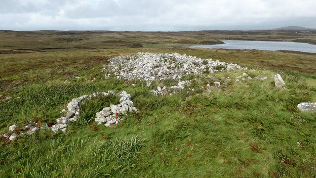
The island is home to a ruined castle, known as Castle Tioram, which dates back to the 13th century. Castle Tioram was once a stronghold of the Clanranald, one of the most powerful clans in the Scottish Highlands. The castle is now in a state of disrepair, but it still attracts tourists who are fascinated by its rich history.

Eilean a' Chàrnain is also known for its diverse wildlife and natural beauty. The island is covered in lush greenery, with a variety of plant species thriving in its fertile soil. It is a haven for birdwatchers, as numerous species of birds can be spotted on the island, including sea eagles, herons, and oystercatchers.

Access to the island is limited, as it can only be reached by boat. However, there are regular boat tours that allow visitors to explore the island and learn about its history and natural heritage. The island offers stunning views of the surrounding mountains and loch, making it a popular destination for nature lovers and photographers.

Overall, Eilean a' Chàrnain is a captivating island that combines historical significance with natural beauty, making it a must-visit destination for anyone exploring the Inverness-shire region of Scotland.

If you have any feedback on the listing, please let us know in the comments section below.

Eilean a' Chàrnain Images

Images are sourced within 2km of 57.505983/-7.2718784 or Grid Reference NF8458. Thanks to Geograph Open Source API. All images are credited.

Ocean on the west side of the causeway to North Uist
NCN780 on Grimsay Looking east, Loch an Fhaing on the left and Eaval, North Uist, in the distance.
NCN780 on Grimsay
Looking east, Loch an Fhaing on the left and Eaval, North Uist, in the distance.
Signpost on Grimsay The house beyond the end of Loch an Fhaing is marked as a Post Office on the map, but the may not be up to date information.
Signpost on Grimsay
The house beyond the end of Loch an Fhaing is marked as a Post Office on the map, but the may not be up to date information.
Bus stop and post box on Grimsay At the road-end of a loop that leaves the main road [A865].
Bus stop and post box on Grimsay
At the road-end of a loop that leaves the main road [A865].
House on Grimsay Looking across Bog Cotton from the A865.
House on Grimsay
Looking across Bog Cotton from the A865.
Near Gearraidh Dubh
Near Gearraidh Dubh
Gairbh-eilean
Gairbh-eilean
Oitir Mhòr
Oitir Mhòr
Barp Hacklett Cairn One cannot be absolutely sure if this is the cairn as the OS map doesn't give a detailed site, but as it is the only pile of stones on a green protuberance on an otherwise rather squelchy moor, then one would suggest that this is it.
Barp Hacklett Cairn
One cannot be absolutely sure if this is the cairn as the OS map doesn't give a detailed site, but as it is the only pile of stones on a green protuberance on an otherwise rather squelchy moor, then one would suggest that this is it.
Moorcroft Campsite at low tide
Eilean an t-Seagail Seating located at a parking spot just off the A865 near Baile Glas on Benbecula.
Eilean an t-Seagail
Seating located at a parking spot just off the A865 near Baile Glas on Benbecula.
Caravat Barp chambered cairn and shieling Large Neolithic long cairn and later historic shieling or shelter (Scale 1m). <span class="nowrap"><a title="https://canmore.org.uk/site/10254/north-uist-carinish-caravat-barp" rel="nofollow ugc noopener" href="https://canmore.org.uk/site/10254/north-uist-carinish-caravat-barp">Link</a><img style="margin-left:2px;" alt="External link" title="External link - shift click to open in new window" src="https://s1.geograph.org.uk/img/external.png" width="10" height="10"/></span>
Caravat Barp chambered cairn and shieling
Large Neolithic long cairn and later historic shieling or shelter (Scale 1m). LinkExternal link
Thatch at Cladach Chairinis
Road on Eilean na h-Airigh Leaving the causeway from Benbecula and heading for Grimsay and North Uist. Eaval / Eabhal is the North Uist mountain in the distance.
<span class="nowrap"><a title="http://www.isle-of-benbecula.co.uk/" rel="nofollow ugc noopener" href="http://www.isle-of-benbecula.co.uk/">Link</a><img style="margin-left:2px;" alt="External link" title="External link - shift click to open in new window" src="https://s1.geograph.org.uk/img/external.png" width="10" height="10"/></span>
Road on Eilean na h-Airigh
Leaving the causeway from Benbecula and heading for Grimsay and North Uist. Eaval / Eabhal is the North Uist mountain in the distance. LinkExternal link
Baile Glas, Grimsay Hamlet on the causewayed road between Benbecula and North Uist.
<span class="nowrap"><a title="http://www.isle-of-benbecula.co.uk/" rel="nofollow ugc noopener" href="http://www.isle-of-benbecula.co.uk/">Link</a><img style="margin-left:2px;" alt="External link" title="External link - shift click to open in new window" src="https://s1.geograph.org.uk/img/external.png" width="10" height="10"/></span>
Baile Glas, Grimsay
Hamlet on the causewayed road between Benbecula and North Uist. LinkExternal link
Sand Flats at Grimsay Tidal flats between Grimsay (foreground) and North Uist (background). Eaval / Eabhal is the distinctive mountain.
Sand Flats at Grimsay
Tidal flats between Grimsay (foreground) and North Uist (background). Eaval / Eabhal is the distinctive mountain.
Grimsay: the post office The island has had a post office since 2 May 1880 and its current location is in a room of the subpostmistress's house, visible here at the end of her long track driveway. The familiar oval sign stands at the end of the drive.

The post office is open for business from 9am, until 12 noon on Mondays and Tuesdays and for an hour longer on Wednesdays.
Grimsay: the post office
The island has had a post office since 2 May 1880 and its current location is in a room of the subpostmistress's house, visible here at the end of her long track driveway. The familiar oval sign stands at the end of the drive. The post office is open for business from 9am, until 12 noon on Mondays and Tuesdays and for an hour longer on Wednesdays.
Grimsay: postbox № HS6 32 One of four postboxes on the island of Grimsay, this postbox stands at a road junction on the A865 close to the post office (<a href="https://www.geograph.org.uk/photo/3112850">NF8457 : Grimsay: the post office</a>) which is in the house in the background. It therefore might be considered the 'main' box on the island and that is reflected in its later collection times - 2pm on weekdays and at 9:45am on Saturdays.
Grimsay: postbox № HS6 32
One of four postboxes on the island of Grimsay, this postbox stands at a road junction on the A865 close to the post office (NF8457 : Grimsay: the post office) which is in the house in the background. It therefore might be considered the 'main' box on the island and that is reflected in its later collection times - 2pm on weekdays and at 9:45am on Saturdays.
Show me another place!

Eilean a' Chàrnain is located at Grid Ref: NF8458 (Lat: 57.505983, Lng: -7.2718784)

Unitary Authority: Na h-Eileanan an Iar

Police Authority: Highlands and Islands

What 3 Words

///shiver.alike.hotdog. Near Balivanich, Na h-Eileanan Siar

Related Wikis

Baile Glas

Baile Glas or Ballaglasa (Scottish Gaelic: Am Baile Glas) is a settlement on Grimsay in the Outer Hebrides, Scotland. Ballaglasa is within the parish of...

Fraoch-Eilean

Fraoch-eilean is a small island with an uncertain population north of Benbecula in the Outer Hebrides of Scotland. It is about 55 hectares (140 acres...

Grimsay

Grimsay (Scottish Gaelic: Griomasaigh) is a tidal island in the Outer Hebrides of Scotland. == Geography == Grimsay is the largest of the low-lying stepping...

Bail' Iochdrach

Bail' Iochdrach or Baliochrach (Scottish Gaelic: Am Baile Ìochdrach) is a village on Benbecula in the Outer Hebrides, Scotland. Baliochrach is within the...

Have you been to Eilean a' Chàrnain?

Leave your review of Eilean a' Chàrnain below (or comments, questions and feedback).