Eilean Dubh Dùn Scor

Island in Inverness-shire

Scotland

Eilean Dubh Dùn Scor

A not very useful gate A rusty old metal gate at the point where a fence once crossed the track.
A not very useful gate Credit: Gordon Hatton

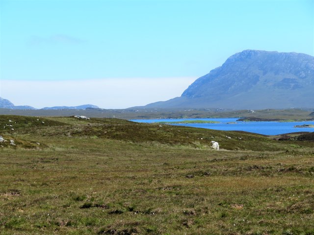
Eilean Dubh Dùn Scor is a small island located in Inverness-shire, Scotland. It is situated in the picturesque Loch Dùn Scor and is surrounded by stunning natural beauty. The island is known for its rich history and archaeological significance.

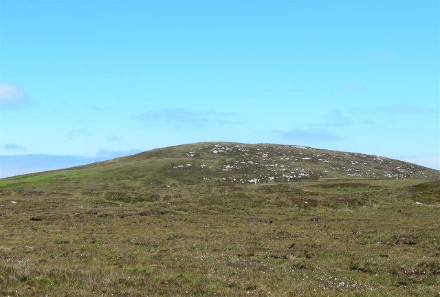
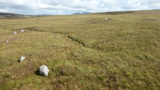
The island measures approximately 1.5 hectares in size and is predominantly rocky, with some areas covered in grass and moss. It is uninhabited and offers a peaceful retreat for those seeking solitude and tranquility.

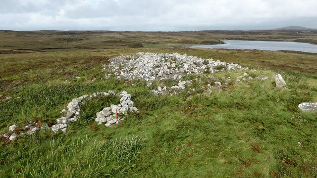
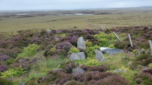
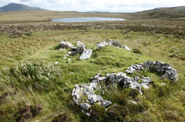
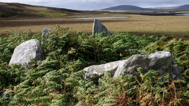
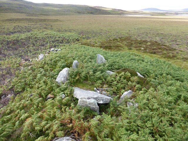
Eilean Dubh Dùn Scor is home to the remnants of an ancient fort, which is believed to have been constructed during the Iron Age. The fort consists of stone walls and defensive structures, providing insight into the island's past and the lives of its inhabitants.

Visitors to Eilean Dubh Dùn Scor can explore the island's archaeological sites and take in the breathtaking views of Loch Dùn Scor and the surrounding mountains. The island is accessible by boat, and guided tours are available to provide historical context and information about the area's significance.

The island's isolation and natural beauty make it a popular destination for nature enthusiasts, bird watchers, and those interested in Scottish history. It offers a unique opportunity to connect with the ancient past and immerse oneself in the rugged landscapes of Inverness-shire.

If you have any feedback on the listing, please let us know in the comments section below.

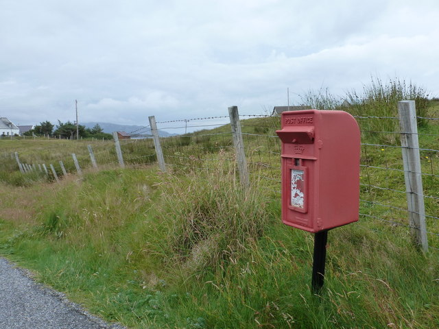
Eilean Dubh Dùn Scor Images

Images are sourced within 2km of 57.537867/-7.2776315 or Grid Reference NF8462. Thanks to Geograph Open Source API. All images are credited.

A not very useful gate A rusty old metal gate at the point where a fence once crossed the track.
A not very useful gate
A rusty old metal gate at the point where a fence once crossed the track.
Track above Loch Creag nan Speireag This track, which is indistinct in places, forms part of the Hebridean Way, a relatively new walking route through the Western Isles.
Track above Loch Creag nan Speireag
This track, which is indistinct in places, forms part of the Hebridean Way, a relatively new walking route through the Western Isles.
Cotton grass, Creag nan Speireag Looking over cotton grass towards Loch nan Speireag and the houses at Gearraidh Cladach.
Cotton grass, Creag nan Speireag
Looking over cotton grass towards Loch nan Speireag and the houses at Gearraidh Cladach.
East from Creag nan Speireag Some 200m from the Hebridean Way path which probably cuts the corner of this square and provides some very 'soft' walking over damp moors. This diversion to a low rise gives a view eastwards towards the oddly shaped Loch Carabhat and distant Eabhal.
East from Creag nan Speireag
Some 200m from the Hebridean Way path which probably cuts the corner of this square and provides some very 'soft' walking over damp moors. This diversion to a low rise gives a view eastwards towards the oddly shaped Loch Carabhat and distant Eabhal.
View towards Beinn na Coille Although this view is across the tiny Loch na Meirle, it remains hidden from sight in a small fold of the moor. Further progress into this square was made difficult by soft ground through old peat workings.
View towards Beinn na Coille
Although this view is across the tiny Loch na Meirle, it remains hidden from sight in a small fold of the moor. Further progress into this square was made difficult by soft ground through old peat workings.
Caravat Barp chambered cairn and shieling Large Neolithic long cairn and later historic shieling or shelter (Scale 1m). <span class="nowrap"><a title="https://canmore.org.uk/site/10254/north-uist-carinish-caravat-barp" rel="nofollow ugc noopener" href="https://canmore.org.uk/site/10254/north-uist-carinish-caravat-barp">Link</a><img style="margin-left:2px;" alt="External link" title="External link - shift click to open in new window" src="https://s1.geograph.org.uk/img/external.png" width="10" height="10"/></span>
Caravat Barp chambered cairn and shieling
Large Neolithic long cairn and later historic shieling or shelter (Scale 1m). LinkExternal link
Craonaval chambered cairn Damaged remains of a chambered cairn hiding in the heather. <span class="nowrap"><a title="https://canmore.org.uk/site/10293/north-uist-craonaval" rel="nofollow ugc noopener" href="https://canmore.org.uk/site/10293/north-uist-craonaval">Link</a><img style="margin-left:2px;" alt="External link" title="External link - shift click to open in new window" src="https://s1.geograph.org.uk/img/external.png" width="10" height="10"/></span>
Craonaval chambered cairn
Damaged remains of a chambered cairn hiding in the heather. LinkExternal link
Two cairns and shielings at Craonaval The stone structures in the foreground are the remains of shielings built into the top of a cairn. <span class="nowrap"><a title="https://canmore.org.uk/site/10284/north-uist-craonaval-south" rel="nofollow ugc noopener" href="https://canmore.org.uk/site/10284/north-uist-craonaval-south">Link</a><img style="margin-left:2px;" alt="External link" title="External link - shift click to open in new window" src="https://s1.geograph.org.uk/img/external.png" width="10" height="10"/></span> A second cairn is visible as a green mound in the middle distance. This cairn contains a possible chamber. <span class="nowrap"><a title="https://canmore.org.uk/site/10253/north-uist-craonaval-north" rel="nofollow ugc noopener" href="https://canmore.org.uk/site/10253/north-uist-craonaval-north">Link</a><img style="margin-left:2px;" alt="External link" title="External link - shift click to open in new window" src="https://s1.geograph.org.uk/img/external.png" width="10" height="10"/></span>
Two cairns and shielings at Craonaval
The stone structures in the foreground are the remains of shielings built into the top of a cairn. LinkExternal link A second cairn is visible as a green mound in the middle distance. This cairn contains a possible chamber. LinkExternal link
Sornach a' Phobuill stone circle A stone circle also known as Sornach Coir' Fhinn. The north western sector survives best. <span class="nowrap"><a title="https://canmore.org.uk/site/10269/north-uist-loch-a-phobuill-sornach-coir-fhinn" rel="nofollow ugc noopener" href="https://canmore.org.uk/site/10269/north-uist-loch-a-phobuill-sornach-coir-fhinn">Link</a><img style="margin-left:2px;" alt="External link" title="External link - shift click to open in new window" src="https://s1.geograph.org.uk/img/external.png" width="10" height="10"/></span>
Sornach a' Phobuill stone circle
A stone circle also known as Sornach Coir' Fhinn. The north western sector survives best. LinkExternal link
Loch Glen Na Feannag shieling and chambered cairn The shieling is built on the edge of a much earlier chambered cairn. <span class="nowrap"><a title="https://canmore.org.uk/site/10251/north-uist-loch-glen-na-feannag" rel="nofollow ugc noopener" href="https://canmore.org.uk/site/10251/north-uist-loch-glen-na-feannag">Link</a><img style="margin-left:2px;" alt="External link" title="External link - shift click to open in new window" src="https://s1.geograph.org.uk/img/external.png" width="10" height="10"/></span>
Loch Glen Na Feannag shieling and chambered cairn
The shieling is built on the edge of a much earlier chambered cairn. LinkExternal link
Loch Glen Na Feannag chambered cairn A close up view of the large slabs forming the chamber. <span class="nowrap"><a title="https://canmore.org.uk/site/10251/north-uist-loch-glen-na-feannag" rel="nofollow ugc noopener" href="https://canmore.org.uk/site/10251/north-uist-loch-glen-na-feannag">Link</a><img style="margin-left:2px;" alt="External link" title="External link - shift click to open in new window" src="https://s1.geograph.org.uk/img/external.png" width="10" height="10"/></span>
Loch Glen Na Feannag chambered cairn
A close up view of the large slabs forming the chamber. LinkExternal link
Oban Nam Fiadh chambered cairn Large stones forming part of the chamber. <span class="nowrap"><a title="https://canmore.org.uk/site/10252/north-uist-oban-nam-fiadh" rel="nofollow ugc noopener" href="https://canmore.org.uk/site/10252/north-uist-oban-nam-fiadh">Link</a><img style="margin-left:2px;" alt="External link" title="External link - shift click to open in new window" src="https://s1.geograph.org.uk/img/external.png" width="10" height="10"/></span>
Oban Nam Fiadh chambered cairn
Large stones forming part of the chamber. LinkExternal link
Oban Nam Fiadh chambered cairn View from above showing the character of the chamber. <span class="nowrap"><a title="https://canmore.org.uk/site/10252/north-uist-oban-nam-fiadh" rel="nofollow ugc noopener" href="https://canmore.org.uk/site/10252/north-uist-oban-nam-fiadh">Link</a><img style="margin-left:2px;" alt="External link" title="External link - shift click to open in new window" src="https://s1.geograph.org.uk/img/external.png" width="10" height="10"/></span>
Oban Nam Fiadh chambered cairn
View from above showing the character of the chamber. LinkExternal link
The community of Locheport on the shore of Loch Eport Seen from the circular way-marked path on Beinn Langais as it leaves the summit and descends to the Pobull Fhinn stone circle.
The community of Locheport on the shore of Loch Eport
Seen from the circular way-marked path on Beinn Langais as it leaves the summit and descends to the Pobull Fhinn stone circle.
End of the B894 The road continues with a sharp bend to Saighdinis, only now coloured yellow on the maps.
End of the B894
The road continues with a sharp bend to Saighdinis, only now coloured yellow on the maps.
Locheport: postbox № HS6 8 A small postbox serving this small community, it is emptied at 9 o'clock on weekday mornings and half an hour earlier on Saturdays.
Locheport: postbox № HS6 8
A small postbox serving this small community, it is emptied at 9 o'clock on weekday mornings and half an hour earlier on Saturdays.
Improved land, Loch Euphort Some of the strip of improved land running along the south side of a sea loch which almost crosses North Uist.
Improved land, Loch Euphort
Some of the strip of improved land running along the south side of a sea loch which almost crosses North Uist.
Oban nam Fiadh A branch of Loch Euphort and there is probably more water than land between here and Eabhal.
Oban nam Fiadh
A branch of Loch Euphort and there is probably more water than land between here and Eabhal.
Show me another place!

Eilean Dubh Dùn Scor is located at Grid Ref: NF8462 (Lat: 57.537867, Lng: -7.2776315)

Unitary Authority: Na h-Eileanan an Iar

Police Authority: Highlands and Islands

What 3 Words

///imprints.chitchat.massaged. Near Balivanich, Na h-Eileanan Siar

Nearby Locations

Eilean Dubh Dùn Scor

Related Wikis

Carinish

Carinish (Scottish Gaelic: Càirinis), is a hamlet on North Uist, in the Outer Hebrides, Scotland. It is in the south of the island, about two miles (three...

Battle of Carinish

The Battle of Carinish was a Scottish clan battle fought in North Uist in 1601. It was part of a year of feuding between Clan MacLeod of Dunvegan and the...

Teampull na Trionaid

Teampull na Trionaid ("trinity church") is a ruined 13th-century Augustinian nunnery at Carinish, on North Uist, in the Outer Hebrides of Scotland. �...

Bail' Iochdrach

Bail' Iochdrach or Baliochrach (Scottish Gaelic: Am Baile Ìochdrach) is a village on Benbecula in the Outer Hebrides, Scotland. Baliochrach is within the...

Related Videos

Rehoming ducks / Midges and checking out the Shetland ducks new home #backyardducks #ducks #love

Rehoming ducks / Midges and checking out the Shetland ducks new home #backyardducks #ducks #love So today is the day we ...

Have you been to Eilean Dubh Dùn Scor?

Leave your review of Eilean Dubh Dùn Scor below (or comments, questions and feedback).