Benks Hills

Range Of Mountains, Range Of Hills in Northumberland

England

Benks Hills

Footpath east of Pudgement Hill Looking east across the rough ground between Pudgement Hill and Burndivot Common. A footpath crosses the land connecting Whiteside and Scotchcoulthard  but this wasn't exactly clear on the ground.
Footpath east of Pudgement Hill Credit: Graham Robson

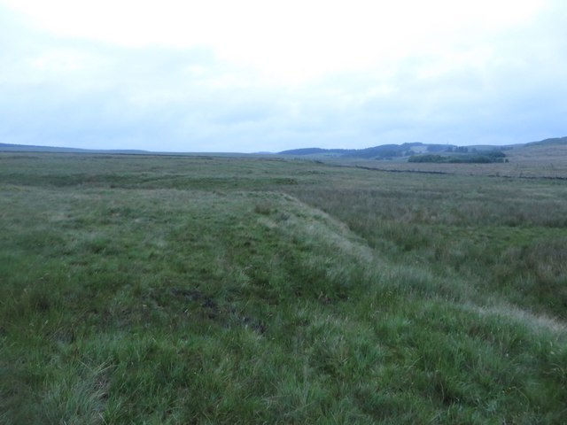
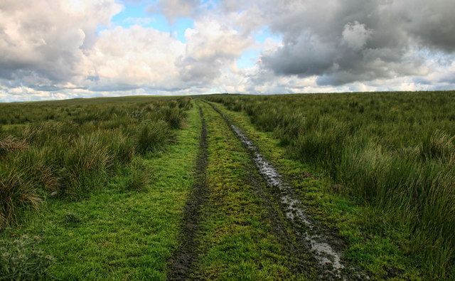
Benks Hills is a prominent range of hills located in the county of Northumberland, England. Situated in the northern part of the county, the hills span an area of approximately 100 square kilometers. Despite being referred to as "hills," the Benks Hills are often classified as a range due to their impressive height and rugged landscape.

The highest peak in the range reaches an elevation of 500 meters above sea level, offering breathtaking panoramic views of the surrounding countryside. The hills are characterized by their steep slopes, rocky outcrops, and deep valleys that have been carved by erosion over millions of years. The terrain is predominantly covered in heather, grasslands, and scattered patches of woodland.

Benks Hills are known for their rich biodiversity and are home to a variety of plant and animal species. The hills provide habitat for several bird species, including the black grouse, curlew, and red kite. Mammals such as red squirrels, rabbits, and deer can also be found within the area.

The range is a popular destination for outdoor enthusiasts, offering opportunities for hiking, walking, and mountain biking. Several well-marked trails crisscross the hills, allowing visitors to explore the diverse landscapes and immerse themselves in the natural beauty of the area. Additionally, the Benks Hills are a haven for wildlife enthusiasts and photographers, providing ample opportunities to observe and capture the region's unique flora and fauna.

Overall, Benks Hills in Northumberland are a picturesque range of hills, offering both natural beauty and recreational activities for visitors to enjoy.

If you have any feedback on the listing, please let us know in the comments section below.

Benks Hills Images

Images are sourced within 2km of 55.012344/-2.4550713 or Grid Reference NY7068. Thanks to Geograph Open Source API. All images are credited.

Footpath east of Pudgement Hill Looking east across the rough ground between Pudgement Hill and Burndivot Common. A footpath crosses the land connecting Whiteside and Scotchcoulthard  but this wasn't exactly clear on the ground.
Footpath east of Pudgement Hill
Looking east across the rough ground between Pudgement Hill and Burndivot Common. A footpath crosses the land connecting Whiteside and Scotchcoulthard but this wasn't exactly clear on the ground.
Pudgement Hill Track on Pudgement Hill.
Pudgement Hill
Track on Pudgement Hill.
Looking to Cawfields from Hadrian's Wall Looking north from Hadrian's Wall towards the farm at Cawfields.
Looking to Cawfields from Hadrian's Wall
Looking north from Hadrian's Wall towards the farm at Cawfields.
Country north of Caw Gap Looking north across open countryside from Hadrian's Wall at Caw Gap.
Country north of Caw Gap
Looking north across open countryside from Hadrian's Wall at Caw Gap.
Great Chesters Farm
Great Chesters Farm
View East looking at the Line of Hadrians Wall
Farms north of Hadrian's Wall The farms are East Cawfields and Cleughfoot.
Farms north of Hadrian's Wall
The farms are East Cawfields and Cleughfoot.
Hadrian's Wall Trail east of Great Chesters
Great Chesters Farm
Great Chesters Farm
Cawfields Farm north of Hadrian's Wall
Pont Gallon Burn north of Edges Green Is Pont Gallon really named after a small French hamlet, Le Pont Gallon, near Doville, or is the name a corruption of something older and more Northumbrian? Could the name be some reference or memory of the 9.5km (4.2km straight line) aqueduct that crossed the burn near Edges Green built by the Romans to convey water to Aesica Roman Fort <a href="https://www.geograph.org.uk/photo/4961741">NY7167 : Remains of Great Chesters Roman Aqueduct</a>?

South of the Military Road (B6318) Pont Gallon Burn becomes the Haltwhistle Burn which flows into the River South Tyne just east of Haltwhistle.

Ventners (or Vintners) Hall is another unusual place name just south of Edges Green.
Pont Gallon Burn north of Edges Green
Is Pont Gallon really named after a small French hamlet, Le Pont Gallon, near Doville, or is the name a corruption of something older and more Northumbrian? Could the name be some reference or memory of the 9.5km (4.2km straight line) aqueduct that crossed the burn near Edges Green built by the Romans to convey water to Aesica Roman Fort NY7167 : Remains of Great Chesters Roman Aqueduct? South of the Military Road (B6318) Pont Gallon Burn becomes the Haltwhistle Burn which flows into the River South Tyne just east of Haltwhistle. Ventners (or Vintners) Hall is another unusual place name just south of Edges Green.
Pont Gallon Burn near High Edges Green
Road north-east of Edges Green The feature beside the track almost dead centre is the remains of a former limekiln.
Road north-east of Edges Green
The feature beside the track almost dead centre is the remains of a former limekiln.
Edges Green The place name, Edges Green, refers to a grassy ridge. It used to be known as Slapy Stones from slippery stepping stones over the Pont Gallon Burn.
Edges Green
The place name, Edges Green, refers to a grassy ridge. It used to be known as Slapy Stones from slippery stepping stones over the Pont Gallon Burn.
Valley of Pont Gallon Burn
Pasture near Edges Green View towards Longsyke Farm with Winshield Crags and Melkridge Common behind.
Pasture near Edges Green
View towards Longsyke Farm with Winshield Crags and Melkridge Common behind.
High Edges Green View from the south near Ventner's Hall.
High Edges Green
View from the south near Ventner's Hall.
Cleughfoot Farm from the east
Show me another place!

Benks Hills is located at Grid Ref: NY7068 (Lat: 55.012344, Lng: -2.4550713)

Unitary Authority: Northumberland

Police Authority: Northumbria

What 3 Words

///published.heightens.forehand. Near Haltwhistle, Northumberland

Nearby Locations

Benks Hill Benks Hills

Related Wikis

Milecastle 43

Milecastle 43 (Great Chesters) was a milecastle on Hadrian's Wall (grid reference NY70356684). It was obliterated when the fort at Great Chesters (Aesica...
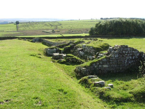
Aesica

Aesica (with the modern name of Great Chesters) was a Roman fort, one and a half miles north of the small town of Haltwhistle in Northumberland, England...

Milecastle 42

Milecastle 42 (Cawfields) is a milecastle on Hadrian's Wall (grid reference NY7157466692). == Description == Milecastle 42 is on a steep south-facing slope...

Milecastle 41

Milecastle 41 (Melkridge) was a milecastle on Hadrian's Wall (grid reference NY73026705). == Description == Milecastle 41 is located to the east of Caw...

Nearby Amenities

Located within 500m of 55.012344,-2.4550713
Benks Hills
Place: locality
Lat/Long: 55.0138848/-2.4598267
Barrier: cattle_grid
Lat/Long: 55.0144794/-2.4503383
The data included in this document is from www.openstreetmap.org. The data is made available under ODbL.

Have you been to Benks Hills?

Leave your review of Benks Hills below (or comments, questions and feedback).