Berwyn

Range Of Mountains, Range Of Hills in Denbighshire

Wales

Berwyn

A view of the Berwyns from Pentre Looking towards Foel Wen.
A view of the Berwyns from Pentre Credit: Richard Green

Berwyn is a range of mountains located in Denbighshire, Wales. It stretches for approximately 24 kilometers (15 miles) from east to west and covers an area of about 180 square kilometers (69 square miles). The highest peak in the range is Cadair Berwyn, which stands at an impressive 827 meters (2,713 feet) above sea level.

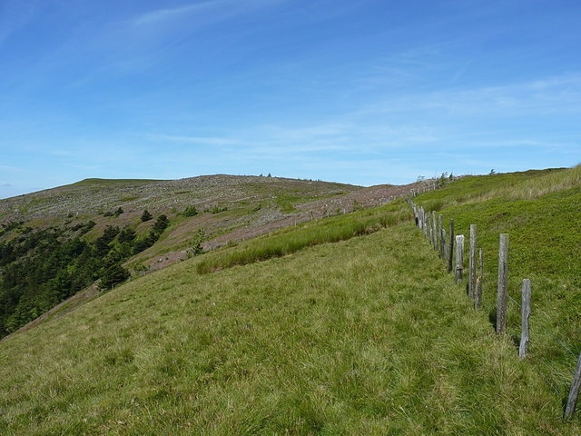
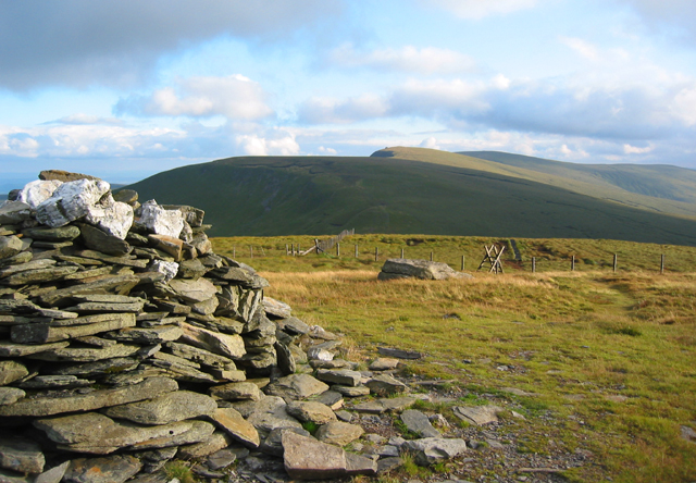
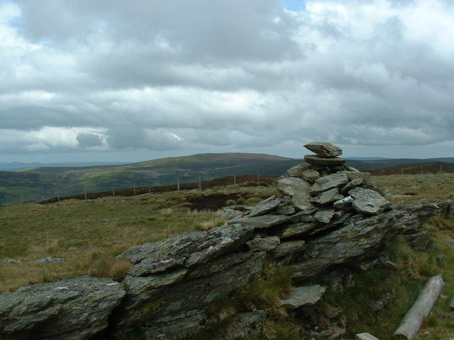
The Berwyn range is characterized by its rugged and wild landscape, with steep slopes, deep valleys, and rocky outcrops. It is predominantly made up of ancient volcanic rocks, which have been shaped and sculpted by glacial activity over thousands of years. As a result, the scenery is dramatic and picturesque, providing breathtaking views of the surrounding countryside.

The Berwyns are renowned for their rich biodiversity and are home to a variety of plant and animal species. The range is covered in heather and grasses, providing habitats for rare and protected species such as the black grouse and the golden plover. The rivers and streams that flow through the valleys support populations of otters, dippers, and Atlantic salmon.

The Berwyn range also holds a significant place in Welsh folklore and history. Legends surrounding the area include tales of buried treasure, magical creatures, and heroic battles. The range was once an important route for travelers and traders, with remnants of ancient pathways still visible today.

For outdoor enthusiasts, the Berwyn range offers a range of activities such as hiking, mountain biking, and wildlife spotting. There are several well-marked trails that traverse the mountains, providing opportunities to explore the stunning scenery and enjoy the tranquility of the natural surroundings.

In conclusion, the Berwyn range in Denbighshire is a captivating and diverse landscape, offering a mix of natural beauty, cultural heritage, and outdoor adventure.

If you have any feedback on the listing, please let us know in the comments section below.

Berwyn Images

Images are sourced within 2km of 52.895994/-3.3254897 or Grid Reference SJ1033. Thanks to Geograph Open Source API. All images are credited.

A view of the Berwyns from Pentre Looking towards Foel Wen.
A view of the Berwyns from Pentre
Looking towards Foel Wen.
Fence line extending westwards from Mynydd Tarw A heathery moorland ridge heads away from the summit area of Mynydd Tarw towards the higher peaks of the Berwyn range; Cadair Berwyn is the flat topped hill at the head of the valley.
Fence line extending westwards from Mynydd Tarw
A heathery moorland ridge heads away from the summit area of Mynydd Tarw towards the higher peaks of the Berwyn range; Cadair Berwyn is the flat topped hill at the head of the valley.
A watersplash by the bridge We were pretty wet by this stage of the ride from Cynwyd, so taking the watersplash at speed seemed a good idea. All part of the fun.
A watersplash by the bridge
We were pretty wet by this stage of the ride from Cynwyd, so taking the watersplash at speed seemed a good idea. All part of the fun.
Ruined sheepfold above the Nant Rhydwilym Little remains of these sheepfolds on the far bank of the stream, apart from some very collapsed walls and piles of rubble.
Ruined sheepfold above the Nant Rhydwilym
Little remains of these sheepfolds on the far bank of the stream, apart from some very collapsed walls and piles of rubble.
Drovers trail and bridge
Mynydd Tarw Cerddwyr yn gadael copa Mynydd Tarw.

Walkers leaving the summit of Mynydd Tarw (bull mountain).
Mynydd Tarw
Cerddwyr yn gadael copa Mynydd Tarw. Walkers leaving the summit of Mynydd Tarw (bull mountain).
Fence adjacent to Foel Wen South Top
Cerrig Geneugiaid
Cerrig Geneugiaid
Summit cairn/shelter on Mynydd Tarw (2234')
West along the ridge of Rhos Looking towards the recently-felled forest patch on Mynydd Tarw
West along the ridge of Rhos
Looking towards the recently-felled forest patch on Mynydd Tarw
Along the ridge on the east side of Mynydd Tarw
Boundary Stone II on Mynydd Tarw Now recumbent, but presumably once embedded in the ground and upright. I tried to pick it up, but to say the least, it's very heavy...
It's described by the Coflein site <span class="nowrap"><a title="https://coflein.gov.uk/en/site/539018/details/mynydd-tarw-boundary-stone-ii" rel="nofollow ugc noopener" href="https://coflein.gov.uk/en/site/539018/details/mynydd-tarw-boundary-stone-ii">Link</a><img style="margin-left:2px;" alt="External link" title="External link - shift click to open in new window" src="https://s1.geograph.org.uk/img/external.png" width="10" height="10"/></span> as " A recumbent freestone monolith, 1.3m high, 0.52m wide and 0.07m thick" and lies on the county boundary of Denbighshire and Montgomeryshire.
Boundary Stone II on Mynydd Tarw
Now recumbent, but presumably once embedded in the ground and upright. I tried to pick it up, but to say the least, it's very heavy... It's described by the Coflein site LinkExternal link as " A recumbent freestone monolith, 1.3m high, 0.52m wide and 0.07m thick" and lies on the county boundary of Denbighshire and Montgomeryshire.
Fenceline on Mynydd Tarw Defining the upper boundary of the former forestry patch, and now separating the clearfelled forest on the left from the open moorland on the right.
Fenceline on Mynydd Tarw
Defining the upper boundary of the former forestry patch, and now separating the clearfelled forest on the left from the open moorland on the right.
Small peaty pool on Mynydd Tarw Lurking in the bilberry and heather to catch out the unwary; it'd be an easy trap to fall into when lightly frozen and covered in snow.
Small peaty pool on Mynydd Tarw
Lurking in the bilberry and heather to catch out the unwary; it'd be an easy trap to fall into when lightly frozen and covered in snow.
The summit cairn on Mynydd Tarw Described as a Round Cairn, clearly hollow in the middle, and probably a prehistoric burial site according to its Coflein listing <span class="nowrap"><a title="https://coflein.gov.uk/en/site/295286/details/mynydd-tarw-summit-cairn" rel="nofollow ugc noopener" href="https://coflein.gov.uk/en/site/295286/details/mynydd-tarw-summit-cairn">Link</a><img style="margin-left:2px;" alt="External link" title="External link - shift click to open in new window" src="https://s1.geograph.org.uk/img/external.png" width="10" height="10"/></span>
The summit cairn on Mynydd Tarw
Described as a Round Cairn, clearly hollow in the middle, and probably a prehistoric burial site according to its Coflein listing LinkExternal link
Cerrig Geneugiaid Another photo of the outcrop of rocks mapped as Cerrig Geneugiaid, on the ridge between Mynydd Tarw and Foel Wen. Older maps mark a couple of boundary stones in the area, but I found no sign of them, and suspect they've been 'repurposed' for fence anchors or similar.
Cerrig Geneugiaid
Another photo of the outcrop of rocks mapped as Cerrig Geneugiaid, on the ridge between Mynydd Tarw and Foel Wen. Older maps mark a couple of boundary stones in the area, but I found no sign of them, and suspect they've been 'repurposed' for fence anchors or similar.
Fenceline on Mynydd Tarw On the ridge running NW from Mynydd Tarw towards Foel Wen
Fenceline on Mynydd Tarw
On the ridge running NW from Mynydd Tarw towards Foel Wen
Fenceline making for Foel Wen A spangly new fence along this section of the ridge.
Fenceline making for Foel Wen
A spangly new fence along this section of the ridge.
Show me another place!

Berwyn is located at Grid Ref: SJ1033 (Lat: 52.895994, Lng: -3.3254897)

Unitary Authority: Wrexham

Police Authority: North Wales

What 3 Words

///stealing.rural.dime. Near Llanrhaeadr-ym-Mochnant, Powys

Nearby Locations

Foel Wen South Top Berwyn

Related Wikis

Cadair Bronwen

Cadair Bronwen is a mountain in North Wales and forms part of the Berwyn range. To the south are the higher Berwyn summits, including Cadair Berwyn. To...

Pen Bwlch Llandrillo

Moel yr Henfaes, also listed by the Nuttall's as Pen Bwlch Llandrillo Top and sometimes known as Moel yr Henfaes, is a mountain in North Wales and forms...

Cadair Berwyn

Cadair Berwyn, Cader Berwyn or Craig Uchaf is a mountain summit in north-east Wales with a height of 832 metres (2,730 ft) above sea level. It is the highest...

Foel Rhudd

Foel Rhudd is a top of Esgeiriau Gwynion in north Wales. It top a wide area of peat bog, the summit marked only by a few stones. Esgeiriau Gwynion summit...

Have you been to Berwyn?

Leave your review of Berwyn below (or comments, questions and feedback).