The Nantlle and Hebog Hills

Range Of Mountains, Range Of Hills in Caernarfonshire

Wales

The Nantlle and Hebog Hills

Enclosure Below Clogwyn Marchnad
Enclosure Below Clogwyn Marchnad Credit: Chris Andrews

The Nantlle and Hebog Hills, located in Caernarfonshire, Wales, are a range of mountains and hills that offer stunning natural beauty and recreational opportunities. This area is renowned for its dramatic landscapes, rich history, and diverse flora and fauna.

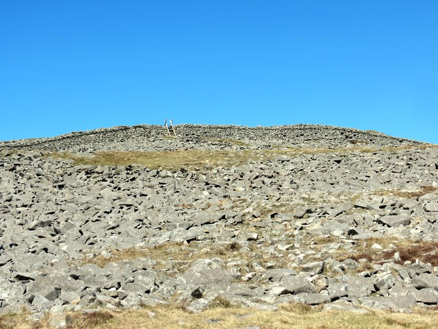
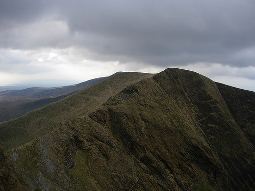
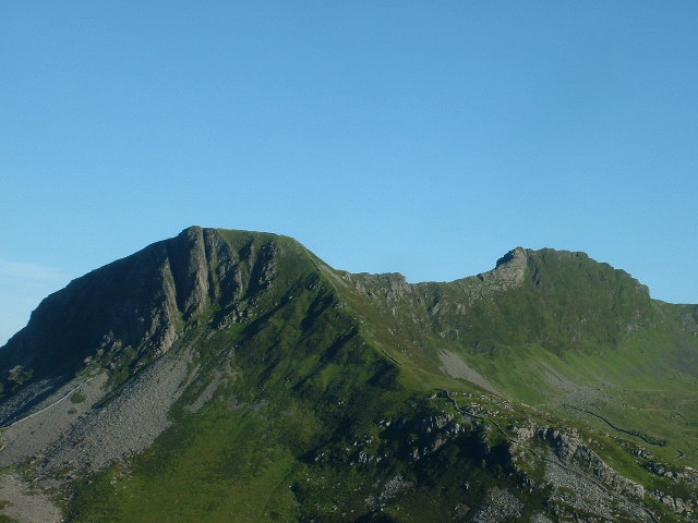
The Nantlle and Hebog Hills are part of the Snowdonia National Park, which is known for its rugged mountains and picturesque valleys. The range comprises several peaks, including Mynydd Mawr (2,029 ft), Y Garn (2,996 ft), Moel Hebog (2,550 ft), and Craig Cwm Silyn (2,482 ft). These peaks provide breathtaking views of the surrounding countryside and are popular among hikers and mountaineers.

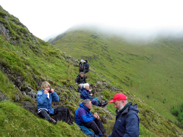
The area also features a network of trails and paths, making it accessible to walkers of all abilities. These trails lead through stunning landscapes, including serene lakes, cascading waterfalls, and lush forests. The Nantlle Valley, located at the foot of the mountains, offers picturesque views and opportunities for leisurely strolls.

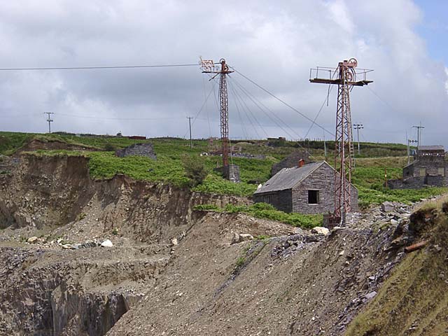
In addition to its natural beauty, the Nantlle and Hebog Hills are steeped in history. Ancient settlements, burial chambers, and standing stones can be found throughout the area, providing a glimpse into the region's past. The summit of Moel Hebog, in particular, is believed to have been a sacred site for the Celts.

The Nantlle and Hebog Hills are home to a wide variety of plant and animal species. The heather-covered slopes provide a habitat for rare plants, while the mountains are home to birds of prey, such as peregrine falcons and buzzards. The area also supports populations of red deer and mountain goats.

Overall, the Nantlle and Hebog Hills in Caernarfonshire offer an enchanting blend of natural beauty, outdoor activities, and historical significance. Whether you are a hiker, history enthusiast, or nature lover, this stunning

If you have any feedback on the listing, please let us know in the comments section below.

The Nantlle and Hebog Hills Images

Images are sourced within 2km of 53.043824/-4.1873139 or Grid Reference SH5351. Thanks to Geograph Open Source API. All images are credited.

Enclosure Below Clogwyn Marchnad
The Path Below Mynydd Drws-y-coed Looking towards Y Garn.
The Path Below Mynydd Drws-y-coed
Looking towards Y Garn.
Obelisk, Mynydd Tal-y-mignedd Built to celebrate the silver jubilee of Queen Victoria.
Obelisk, Mynydd Tal-y-mignedd
Built to celebrate the silver jubilee of Queen Victoria.
Bwlch Dros-bern Craig Pennant in the distance.
Bwlch Dros-bern
Craig Pennant in the distance.
Cwm Dwyfor Copper Mine Showing the wheel pit and crusher house. Abandoned by 1877.
Cwm Dwyfor Copper Mine
Showing the wheel pit and crusher house. Abandoned by 1877.
Craig Cwm Silyn
Craig Cwm Silyn
Drws-y-coed The view from Craig y Bera.
Drws-y-coed
The view from Craig y Bera.
Dyffryn Nanttle ...Nantlle Valley A late November day with the rare combination of blue skies and fairly warm weather.
Looking east from the B4418 near Nantlle. 
Past sheep grazing on the grassland by Llyn Nantlle Uchaf; and on up the Nantlle Valley towards clouds drifting over the tops of the Snowdon massif in the distance
Dyffryn Nanttle ...Nantlle Valley
A late November day with the rare combination of blue skies and fairly warm weather. Looking east from the B4418 near Nantlle. Past sheep grazing on the grassland by Llyn Nantlle Uchaf; and on up the Nantlle Valley towards clouds drifting over the tops of the Snowdon massif in the distance
Tuag at y Garn / Towards y Garn Agosau at y wal cerrig sych ger copa'r Garn.

Approaching the dry stone wall near the summit of Y Garn (trans. the cairn)
Tuag at y Garn / Towards y Garn
Agosau at y wal cerrig sych ger copa'r Garn. Approaching the dry stone wall near the summit of Y Garn (trans. the cairn)
Bwlch Dros-bern Bwlch Dros-bern ac yn y pellter mae Craig Cwm Silyn, y fan uchaf ar Grib Nantlle.

Bwlch Dros-bern and in the distance Craig Cwm Silyn, the highest peak on the Nantlle Ridge.
Bwlch Dros-bern
Bwlch Dros-bern ac yn y pellter mae Craig Cwm Silyn, y fan uchaf ar Grib Nantlle. Bwlch Dros-bern and in the distance Craig Cwm Silyn, the highest peak on the Nantlle Ridge.
Craig Cwm Silyn Y garn ar gopa Craig Cwm Silyn.

The cairn on the summit of Craig Cwm Silyn.
Craig Cwm Silyn
Y garn ar gopa Craig Cwm Silyn. The cairn on the summit of Craig Cwm Silyn.
O dan Drum y Ddysgl/  Below Trum y Ddysgl Cerddwyr yn cael seibiant o dan Drum y Ddysgl sydd wedi ei guddio gan nudden. 

Walkers having a breather below Trum y Ddysgl which is shrouded in mist.
O dan Drum y Ddysgl/ Below Trum y Ddysgl
Cerddwyr yn cael seibiant o dan Drum y Ddysgl sydd wedi ei guddio gan nudden. Walkers having a breather below Trum y Ddysgl which is shrouded in mist.
Descending from Bwlch Dros-bern to Cwm Afon Craig-las A tributary streamlet of the Afon Craig-las tumbles down from near Bwlch Dros-bern to the boggy valley floor.
Descending from Bwlch Dros-bern to Cwm Afon Craig-las
A tributary streamlet of the Afon Craig-las tumbles down from near Bwlch Dros-bern to the boggy valley floor.
Head of Cwm Afon Craig-las below Craig Cwm Silyn A section of the northern crags of Craig Cwm Silyn plunge down to meet the very boggy flatland of Cwm Afon Craig-las. The edge is a mixture of grass, bog and skew boulders, a superb fragment of virtually untrodden wild Wales.
Head of Cwm Afon Craig-las below Craig Cwm Silyn
A section of the northern crags of Craig Cwm Silyn plunge down to meet the very boggy flatland of Cwm Afon Craig-las. The edge is a mixture of grass, bog and skew boulders, a superb fragment of virtually untrodden wild Wales.
Head of Cwm Afon Craig-las below Mynydd Tal-y-mignedd View east towards Mynydd Tal-y-mignedd along the edge of the very boggy valley floor where it meets the crags of Craig Cwm Silyn. The tall columnar cairn on Mynydd Tal-y-mignedd can just be seen. After picking our way along the edge through the skew rocks and wet reeds to this point, surprisingly we found a ladder stile that we imagine has seen very few feet.
Head of Cwm Afon Craig-las below Mynydd Tal-y-mignedd
View east towards Mynydd Tal-y-mignedd along the edge of the very boggy valley floor where it meets the crags of Craig Cwm Silyn. The tall columnar cairn on Mynydd Tal-y-mignedd can just be seen. After picking our way along the edge through the skew rocks and wet reeds to this point, surprisingly we found a ladder stile that we imagine has seen very few feet.
Western pool on the saddle below Craig Cwm Silyn There are two pools on the boggy elevated saddle separating Cwm Silyn and Cwm Afon Craig-las, this is the western pool that has more open water than the larger but reedier easterly one. The vibrant colour of the August heather and pool/bog flora made a splendid scene below the crags, yet this pocket of wild Wales seems virtually untrodden.
Western pool on the saddle below Craig Cwm Silyn
There are two pools on the boggy elevated saddle separating Cwm Silyn and Cwm Afon Craig-las, this is the western pool that has more open water than the larger but reedier easterly one. The vibrant colour of the August heather and pool/bog flora made a splendid scene below the crags, yet this pocket of wild Wales seems virtually untrodden.
Reedy pool on the boggy saddle below Craig Cwm Silyn This is the easterly pool of the pair on the boggy saddle separating Cwm Silyn and Cwm Craig Afon-las. This view towards Mynydd Tal-y-mignedd emphasizes the vibrant colours of the heather and bog grasses that show this wild pocket of Wales at its best, and where extremely few feet venture.
Reedy pool on the boggy saddle below Craig Cwm Silyn
This is the easterly pool of the pair on the boggy saddle separating Cwm Silyn and Cwm Craig Afon-las. This view towards Mynydd Tal-y-mignedd emphasizes the vibrant colours of the heather and bog grasses that show this wild pocket of Wales at its best, and where extremely few feet venture.
Rhyd-Ddu 2 Miles Old milestone near to Rhyd-Ddu, Gwynedd. For overall view see <a title="https://www.geograph.org.uk/photo/5373620" href="https://www.geograph.org.uk/photo/5373620">Link</a>
Rhyd-Ddu 2 Miles
Old milestone near to Rhyd-Ddu, Gwynedd. For overall view see Link
Show me another place!

The Nantlle and Hebog Hills is located at Grid Ref: SH5351 (Lat: 53.043824, Lng: -4.1873139)

Unitary Authority: Gwynedd

Police Authority: North Wales

What 3 Words

///evoke.impulses.twins. Near Talysarn, Gwynedd

Related Wikis

Mynydd Tal-y-Mignedd

Mynydd Tal-y-Mignedd is a peak on the Nantlle Ridge in Snowdonia, north Wales. It is located at the centre of the ridge, and is a subsidiary summit of...

Trum y Ddysgl

Trum y Ddysgl is a mountain in Snowdonia, north Wales and is the second highest summit on the celebrated Nantlle Ridge. It is also one half of the two...

Mynydd Drws-y-Coed

Mynydd Drws-y-Coed is a peak on the Nantlle Ridge in Snowdonia, north Wales. It is located at the easterly end of the ridge, and is a subsidiary summit...

Y Garn (Nantlle Ridge)

Y Garn is a top of Mynydd Drws-y-Coed in Snowdonia, north Wales and is the easterly end of the Nantlle Ridge.It has steep north-facing cliffs, the summit...

Llyn Nantlle Uchaf

Llyn Nantlle Uchaf (Welsh for 'Upper Nantlle Lake') is a lake in the Nantlle Valley, Gwynedd, Wales. The lake forms the foreground in Richard Wilson's...

Mynydd Mawr

Mynydd Mawr (Welsh for big mountain) is a mountain in Snowdonia, North Wales, approximately 7 km (4.3 mi) west of Snowdon itself, overlooking Llyn Cwellyn...

Nantlle

Nantlle () is a small village in the slate quarrying Nantlle Valley in Gwynedd, Wales. It lies on the north shore of Llyn Nantlle Uchaf and is part of...

Pen-yr-Orsedd quarry

Pen-yr-Orsedd quarry was a slate quarry in the Nantlle Valley in North Wales. It was one of the last slate quarries operating in North Wales and the last...

Nearby Amenities

Located within 500m of 53.043824,-4.1873139
Mynydd Tal-y-Mignedd
Ele: 653
Natural: peak
Source Name: npe
Wikidata: Q20601199
Wikipedia: en:Mynydd Tal-y-Mignedd
Lat/Long: 53.0397498/-4.1860227
Victoria Jubilee monument
Historic: monument
Man Made: obelisk
Wikimedia Commons: File:Obelisk on Mynydd Tal-y-mignedd - geograph.org.uk - 51705.jpg
Lat/Long: 53.039747/-4.1860564
Cwmyffynnon
Place: locality
Lat/Long: 53.0452987/-4.183889
The data included in this document is from www.openstreetmap.org. The data is made available under ODbL.

Have you been to The Nantlle and Hebog Hills?

Leave your review of The Nantlle and Hebog Hills below (or comments, questions and feedback).