Seven Hills

Range Of Mountains, Range Of Hills in Devon North Devon

England

Seven Hills

The South West Coast Path
The South West Coast Path Credit: Tim Glover

The requested URL returned error: 429 Too Many Requests

If you have any feedback on the listing, please let us know in the comments section below.

Seven Hills Images

Images are sourced within 2km of 51.20597/-4.1377874 or Grid Reference SS5047. Thanks to Geograph Open Source API. All images are credited.

The South West Coast Path
Footpath and track to Whitestone Farm
Lincombe House
Lincombe House
High Banks, Lincombe
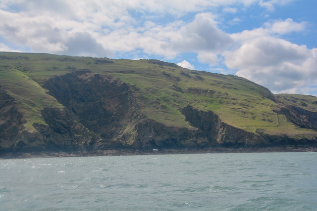
North Devon : Coastal Scenery Looking towards Flat Point on the North Devon coastline.
North Devon : Coastal Scenery
Looking towards Flat Point on the North Devon coastline.
North Devon : Coastal Scenery Looking across the North Devon coastline and towards Flat Point.
North Devon : Coastal Scenery
Looking across the North Devon coastline and towards Flat Point.
North Devon : Coastal Scenery Looking towards Sheepstor on the North Devon coastline.
North Devon : Coastal Scenery
Looking towards Sheepstor on the North Devon coastline.
North Devon : Coastal Scenery Looking across the North Devon coastline.
North Devon : Coastal Scenery
Looking across the North Devon coastline.
North Devon : Coastal Scenery Looking across the North Devon coastline.
North Devon : Coastal Scenery
Looking across the North Devon coastline.
House in Lincombe Lincombe.
House in Lincombe
Lincombe.
SWCP near Lincombe Looking towards Ilfracombe.
SWCP near Lincombe
Looking towards Ilfracombe.
Near Whitestone Farm - 1999
North Devon : Stile & Hedgerow I had my shorts on today which made stiles like this somewhat tricky.
North Devon : Stile & Hedgerow
I had my shorts on today which made stiles like this somewhat tricky.
North Devon : Grassy Field A grassy field with a right of way heading through it.
North Devon : Grassy Field
A grassy field with a right of way heading through it.
North Devon : Grassy Field A grassy field with a right of way heading through it towards Lincombe Farm.
North Devon : Grassy Field
A grassy field with a right of way heading through it towards Lincombe Farm.
Lincombe : Lincombe Farm Lincombe Farm with a tractor out in the yard.
Lincombe : Lincombe Farm
Lincombe Farm with a tractor out in the yard.
Lincombe : Country Lane A small lane heading through the hamlet of Lincombe in North Devon.
Lincombe : Country Lane
A small lane heading through the hamlet of Lincombe in North Devon.
Lincombe : Country Lane A small lane heading down the hill and into the coastal hamlet of Lee.
Lincombe : Country Lane
A small lane heading down the hill and into the coastal hamlet of Lee.
Show me another place!

Seven Hills is located at Grid Ref: SS5047 (Lat: 51.20597, Lng: -4.1377874)

Administrative County: Devon

District: North Devon

Police Authority: Devon and Cornwall

What 3 Words

///songbirds.squirts.speeded. Near Ilfracombe, Devon

Related Wikis

The Torrs

The Torrs are a Local Nature Reserve and one of the four main hills in the North Devon coastal town of Ilfracombe. The Park originally was designed in...

Holy Trinity Church, Ilfracombe

The Church of the Holy Trinity is the Anglican parish church for Ilfracombe in Devon. The building has been a Grade I listed building since 1951 and comes...

Ilfracombe railway station (England)

Ilfracombe railway station was the terminus of the Ilfracombe branch line in north Devon, England. The line was opened as the Barnstaple and Ilfracombe...

Old Town Hall, Ilfracombe

The Old Town Hall is a former municipal building in the High Street in Ilfracombe, Devon, England. The structure, which currently operates as gym, is a...

Nearby Amenities

Located within 500m of 51.20597,-4.1377874
Source: PGS
Lat/Long: 51.2095904/-4.134637
Source: PGS
Lat/Long: 51.2090731/-4.136008
Source: PGS
Lat/Long: 51.2088693/-4.1373844
Source: PGS
Lat/Long: 51.2082897/-4.1377703
Source: PGS
Lat/Long: 51.2081733/-4.1377537
Source: PGS
Lat/Long: 51.208025/-4.1376716
Source: PGS
Lat/Long: 51.2080009/-4.1379697
Source: PGS
Lat/Long: 51.2079719/-4.1380783
Source: PGS
Lat/Long: 51.2080408/-4.1393318
Source: PGS
Lat/Long: 51.2078939/-4.1392057
Source: PGS
Lat/Long: 51.207636/-4.1396047
Source: PGS
Lat/Long: 51.2074136/-4.1400871
Source: PGS
Lat/Long: 51.2073501/-4.1403254
Source: PGS
Lat/Long: 51.2073462/-4.1406452
Source: PGS
Lat/Long: 51.2075144/-4.141113
Source: PGS
Lat/Long: 51.207411/-4.142716
Source: PGS
Lat/Long: 51.2070356/-4.1428238
Source: PGS
Lat/Long: 51.2067134/-4.1444122
Source: PGS
Lat/Long: 51.2065089/-4.1444844
Barrier: wall
Lat/Long: 51.2037534/-4.1370365
Natural: peak
Lat/Long: 51.2063779/-4.1373051
Torres Point
Place: locality
Lat/Long: 51.2094383/-4.1370375
Breakneck Point
Place: locality
Lat/Long: 51.207161/-4.1440473
Brandy Cove Point
Place: locality
Lat/Long: 51.2077407/-4.1419963
Source: PGS
Lat/Long: 51.2051463/-4.144305
Source: PGS
Lat/Long: 51.2057078/-4.1434747
Source: PGS
Lat/Long: 51.2060801/-4.1430384
Source: PGS
Lat/Long: 51.2066757/-4.1427865
Source: PGS
Lat/Long: 51.2060791/-4.1421321
Source: PGS
Lat/Long: 51.20638/-4.1415554
Source: PGS
Lat/Long: 51.206295/-4.1394344
Source: PGS
Lat/Long: 51.2063552/-4.1400036
Source: PGS
Lat/Long: 51.2064483/-4.1390042
Source: PGS
Lat/Long: 51.2064822/-4.1405497
Source: PGS
Lat/Long: 51.2065894/-4.1416944
Source: PGS
Lat/Long: 51.2071051/-4.139193
Source: PGS
Lat/Long: 51.207248/-4.1374699
Source: PGS
Lat/Long: 51.2076137/-4.1370012
Source: PGS
Lat/Long: 51.2073011/-4.138344
Source: PGS
Lat/Long: 51.2071473/-4.1416534
Source: PGS
Lat/Long: 51.2073441/-4.1361714
Source: PGS
Lat/Long: 51.2073339/-4.1411709
Source: PGS
Lat/Long: 51.2080004/-4.1354869
Source: PGS
Lat/Long: 51.2080816/-4.1351056
Source: PGS
Lat/Long: 51.2083787/-4.1331313
Source: PGS
Lat/Long: 51.2082767/-4.1347978
Source: PGS
Lat/Long: 51.20908/-4.1350627
Source: PGS
Lat/Long: 51.2077229/-4.1380042
Natural: peak
Lat/Long: 51.2048279/-4.1377355
Brandy
Natural: bay
Source: OS_OpenData_StreetView
Lat/Long: 51.2070115/-4.1423598
Arganite Bay
Natural: bay
Source: OS_OpenData_StreetView
Lat/Long: 51.2096661/-4.1337767
White Pebble Bay
Natural: bay
Source: OS_OpenData_StreetView
Lat/Long: 51.208416/-4.1389802
The Whistler
Natural: bay
Source: OS_OpenData_StreetView
Lat/Long: 51.2090814/-4.1387024
Barrier: stile
Lat/Long: 51.2056641/-4.1379147
Tourism: viewpoint
Lat/Long: 51.20643/-4.137273
Access: no
Barrier: stile
Foot: yes
Lat/Long: 51.2053924/-4.1350557
Generator Method: photovoltaic
Generator Output Electricity: yes
Generator Source: solar
Generator Type: solar_photovoltaic_panel
Location: roof
Power: generator
Lat/Long: 51.2047015/-4.1310592
Generator Method: photovoltaic
Generator Output Electricity: yes
Generator Source: solar
Generator Type: solar_photovoltaic_panel
Location: roof
Power: generator
Lat/Long: 51.2053392/-4.1308795
Generator Method: photovoltaic
Generator Output Electricity: yes
Generator Source: solar
Generator Type: solar_photovoltaic_panel
Location: roof
Power: generator
Lat/Long: 51.205346/-4.1306998
Generator Method: photovoltaic
Generator Output Electricity: yes
Generator Source: solar
Generator Type: solar_photovoltaic_panel
Location: roof
Power: generator
Lat/Long: 51.2038749/-4.1319737
Generator Method: photovoltaic
Generator Output Electricity: yes
Generator Source: solar
Generator Type: solar_photovoltaic_panel
Location: roof
Power: generator
Lat/Long: 51.2038749/-4.1320273
Generator Method: photovoltaic
Generator Output Electricity: yes
Generator Source: solar
Generator Type: solar_photovoltaic_panel
Location: roof
Power: generator
Lat/Long: 51.2037522/-4.1331458
Generator Method: photovoltaic
Generator Output Electricity: yes
Generator Source: solar
Generator Type: solar_photovoltaic_panel
Location: roof
Power: generator
Lat/Long: 51.2022547/-4.1339186
Generator Method: photovoltaic
Generator Output Electricity: yes
Generator Source: solar
Generator Type: solar_photovoltaic_panel
Location: roof
Power: generator
Lat/Long: 51.2024369/-4.1348343
Generator Method: photovoltaic
Generator Output Electricity: yes
Generator Source: solar
Generator Type: solar_photovoltaic_panel
Location: roof
Power: generator
Lat/Long: 51.206117/-4.132902
Generator Method: photovoltaic
Generator Output Electricity: yes
Generator Source: solar
Generator Type: solar_photovoltaic_panel
Location: roof
Power: generator
Lat/Long: 51.2060711/-4.1329693
Generator Method: photovoltaic
Generator Output Electricity: yes
Generator Source: solar
Generator Type: solar_photovoltaic_panel
Location: roof
Power: generator
Lat/Long: 51.2060448/-4.1330078
Source: PGS
Lat/Long: 51.2048253/-4.1432284
Source: PGS
Lat/Long: 51.2050833/-4.1430314
Source: PGS
Lat/Long: 51.2054886/-4.1424873
Source: PGS
Lat/Long: 51.2057741/-4.1421792
Source: PGS
Lat/Long: 51.2059512/-4.1412594
Source: PGS
Lat/Long: 51.2062201/-4.1412594
The data included in this document is from www.openstreetmap.org. The data is made available under ODbL.

Have you been to Seven Hills?

Leave your review of Seven Hills below (or comments, questions and feedback).