Otty Bottom
Valley in Kent Dover
England
Otty Bottom

Otty Bottom is a small rural area located in Kent, England, specifically in the Valley region. Situated within the picturesque countryside, it offers a tranquil and idyllic setting for residents and visitors alike. Otty Bottom is known for its natural beauty, characterized by rolling hills, lush greenery, and charming cottages dotted along the landscape.
This quaint village is home to a close-knit community, fostering a warm and friendly atmosphere. The residents of Otty Bottom take pride in their community, actively engaging in various local events and initiatives. Community gatherings, such as summer fairs and village markets, are a regular occurrence, strengthening the bonds between residents and fostering a sense of belonging.
Despite its rural setting, Otty Bottom benefits from its proximity to some larger towns in Kent. The village is a short drive away from the bustling town center of Sevenoaks, offering residents convenient access to a range of amenities, including shops, restaurants, and recreational facilities.
Otty Bottom is also blessed with an abundance of natural attractions and outdoor activities. The surrounding countryside provides ample opportunities for hiking, cycling, and exploring the scenic countryside. Additionally, the nearby Otty Bottom River is a popular spot for fishing enthusiasts.
Overall, Otty Bottom in Kent (Valley) is a picturesque and welcoming village, offering residents a peaceful and close-knit community, as well as easy access to both rural and urban amenities.
If you have any feedback on the listing, please let us know in the comments section below.
Otty Bottom Images
Images are sourced within 2km of 51.172175/1.3907806 or Grid Reference TR3746. Thanks to Geograph Open Source API. All images are credited.


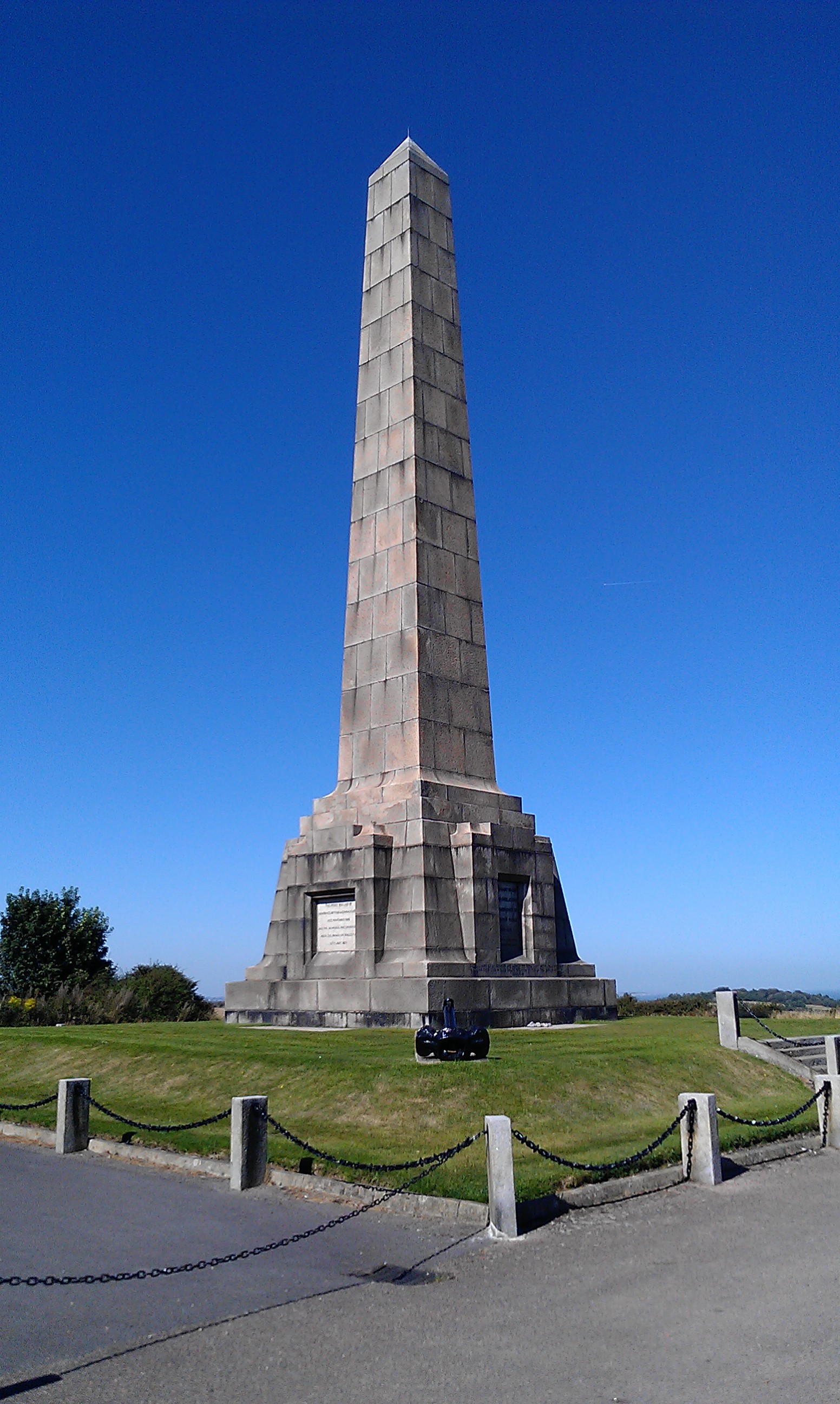
![A walk from St Margaretâs at Cliffe to Kingsdown and return [1] This monument at Leathercoat Point was erected in 1921 as a memorial to the Dover Patrol in WWI. There are identical monuments in France and in New York. Constructed of ashlar blocks, about 80 feet high. Listed, grade II*, with details at: historicengland.org.uk/listing/the-list/list-entry/1070067
Starting from the Dover Patrol Monument, the walk follows the long distance Saxon Shore Way along the top of the cliffs before descending to the bay at Kingsdown. Heading inland there is an ascent of Wood Hill before various rights of way run across fields to the wonderfully named Otty Bottom, then on to Free Down and a return to the starting point. A little more than 5 miles.](https://s0.geograph.org.uk/geophotos/07/08/49/7084960_5fb94790.jpg)
![A walk from St Margaretâs at Cliffe to Kingsdown and return [2] The path heads north along the cliff tops. From here to Kingsdown the path is part of three long distance paths. The England Coast Path, the Saxon Shore Way and the White Cliffs Country Trail.
Starting from the Dover Patrol Monument, the walk follows the long distance Saxon Shore Way along the top of the cliffs before descending to the bay at Kingsdown. Heading inland there is an ascent of Wood Hill before various rights of way run across fields to the wonderfully named Otty Bottom, then on to Free Down and a return to the starting point. A little more than 5 miles.](https://s1.geograph.org.uk/geophotos/07/08/49/7084961_ffab8a6a.jpg)
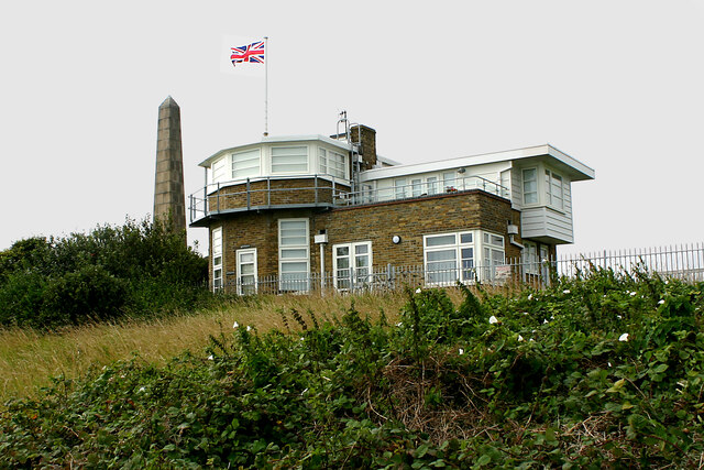
![A walk from St Margaretâs at Cliffe to Kingsdown and return [3] This building appears to be a coastal lookout. On the OS map it is marked as a tearoom.
Starting from the Dover Patrol Monument, the walk follows the long distance Saxon Shore Way along the top of the cliffs before descending to the bay at Kingsdown. Heading inland there is an ascent of Wood Hill before various rights of way run across fields to the wonderfully named Otty Bottom, then on to Free Down and a return to the starting point. A little more than 5 miles.](https://s3.geograph.org.uk/geophotos/07/08/49/7084963_3f47163f.jpg)
![A walk from St Margaretâs at Cliffe to Kingsdown and return [4] North along the cliff top.
Starting from the Dover Patrol Monument, the walk follows the long distance Saxon Shore Way along the top of the cliffs before descending to the bay at Kingsdown. Heading inland there is an ascent of Wood Hill before various rights of way run across fields to the wonderfully named Otty Bottom, then on to Free Down and a return to the starting point. A little more than 5 miles.](https://s0.geograph.org.uk/geophotos/07/08/49/7084964_33d23893.jpg)
![A walk from St Margaretâs at Cliffe to Kingsdown and return [5] Looking north from the path and the first glimpse of white chalk.
Starting from the Dover Patrol Monument, the walk follows the long distance Saxon Shore Way along the top of the cliffs before descending to the bay at Kingsdown. Heading inland there is an ascent of Wood Hill before various rights of way run across fields to the wonderfully named Otty Bottom, then on to Free Down and a return to the starting point. A little more than 5 miles.](https://s1.geograph.org.uk/geophotos/07/08/49/7084965_f29314bb.jpg)
![A walk from St Margaretâs at Cliffe to Kingsdown and return [6] The path continues to head north along the cliff tops. From here to Kingsdown the path is part of three long distance paths. The England Coast Path, the Saxon Shore Way and the White Cliffs Country Trail.
Starting from the Dover Patrol Monument, the walk follows the long distance Saxon Shore Way along the top of the cliffs before descending to the bay at Kingsdown. Heading inland there is an ascent of Wood Hill before various rights of way run across fields to the wonderfully named Otty Bottom, then on to Free Down and a return to the starting point. A little more than 5 miles.](https://s2.geograph.org.uk/geophotos/07/08/49/7084966_a91838df.jpg)
![A walk from St Margaretâs at Cliffe to Kingsdown and return [7] A view back along the path with the Dover Patrol Monument prominent.
Starting from the Dover Patrol Monument, the walk follows the long distance Saxon Shore Way along the top of the cliffs before descending to the bay at Kingsdown. Heading inland there is an ascent of Wood Hill before various rights of way run across fields to the wonderfully named Otty Bottom, then on to Free Down and a return to the starting point. A little more than 5 miles.](https://s3.geograph.org.uk/geophotos/07/08/49/7084967_1b69f27a.jpg)
![A walk from St Margaretâs at Cliffe to Kingsdown and return [8] From the cliff top path, this path branches off and leads to St Margaret's Free Down.
Starting from the Dover Patrol Monument, the walk follows the long distance Saxon Shore Way along the top of the cliffs before descending to the bay at Kingsdown. Heading inland there is an ascent of Wood Hill before various rights of way run across fields to the wonderfully named Otty Bottom, then on to Free Down and a return to the starting point. A little more than 5 miles.](https://s2.geograph.org.uk/geophotos/07/08/49/7084970_96d30c90.jpg)
![A walk from St Margaretâs at Cliffe to Kingsdown and return [9] The path passes through the gate and offers glimpses of the white cliffs in the distance.
Starting from the Dover Patrol Monument, the walk follows the long distance Saxon Shore Way along the top of the cliffs before descending to the bay at Kingsdown. Heading inland there is an ascent of Wood Hill before various rights of way run across fields to the wonderfully named Otty Bottom, then on to Free Down and a return to the starting point. A little more than 5 miles.](https://s0.geograph.org.uk/geophotos/07/08/49/7084972_abb1dccf.jpg)
![A walk from St Margaretâs at Cliffe to Kingsdown and return [10] Seen from the path is this schooner.
Starting from the Dover Patrol Monument, the walk follows the long distance Saxon Shore Way along the top of the cliffs before descending to the bay at Kingsdown. Heading inland there is an ascent of Wood Hill before various rights of way run across fields to the wonderfully named Otty Bottom, then on to Free Down and a return to the starting point. A little more than 5 miles.](https://s1.geograph.org.uk/geophotos/07/08/49/7084973_923d3e8d.jpg)
![A walk from St Margaretâs at Cliffe to Kingsdown and return [11] The path continues north along the cliff top with the odd glimpse of the white chalk.
Starting from the Dover Patrol Monument, the walk follows the long distance Saxon Shore Way along the top of the cliffs before descending to the bay at Kingsdown. Heading inland there is an ascent of Wood Hill before various rights of way run across fields to the wonderfully named Otty Bottom, then on to Free Down and a return to the starting point. A little more than 5 miles.](https://s2.geograph.org.uk/geophotos/07/08/49/7084974_f6d65af9.jpg)
![A walk from St Margaretâs at Cliffe to Kingsdown and return [12] A view out to sea and a bench for the weary walker.
Starting from the Dover Patrol Monument, the walk follows the long distance Saxon Shore Way along the top of the cliffs before descending to the bay at Kingsdown. Heading inland there is an ascent of Wood Hill before various rights of way run across fields to the wonderfully named Otty Bottom, then on to Free Down and a return to the starting point. A little more than 5 miles.](https://s0.geograph.org.uk/geophotos/07/08/56/7085628_40520eae.jpg)
![A walk from St Margaretâs at Cliffe to Kingsdown and return [13] The path continues to head north along the cliff tops.
Starting from the Dover Patrol Monument, the walk follows the long distance Saxon Shore Way along the top of the cliffs before descending to the bay at Kingsdown. Heading inland there is an ascent of Wood Hill before various rights of way run across fields to the wonderfully named Otty Bottom, then on to Free Down and a return to the starting point. A little more than 5 miles.](https://s1.geograph.org.uk/geophotos/07/08/56/7085629_faaf63b6.jpg)
![A walk from St Margaretâs at Cliffe to Kingsdown and return [14] Little Green is a house with a view. Seen from the path.
Starting from the Dover Patrol Monument, the walk follows the long distance Saxon Shore Way along the top of the cliffs before descending to the bay at Kingsdown. Heading inland there is an ascent of Wood Hill before various rights of way run across fields to the wonderfully named Otty Bottom, then on to Free Down and a return to the starting point. A little more than 5 miles.](https://s2.geograph.org.uk/geophotos/07/08/56/7085630_bc548c3c.jpg)
Otty Bottom is located at Grid Ref: TR3746 (Lat: 51.172175, Lng: 1.3907806)
Administrative County: Kent
District: Dover
Police Authority: Kent
What 3 Words
///scrubber.appeal.darkest. Near Deal, Kent
Nearby Locations
Related Wikis

Ringwould with Kingsdown
Ringwould with Kingsdown is a coastal civil parish in the Dover District of Kent, England. The parish contains the villages of Ringwould and Kingsdown...

Kingsdown, Dover
Kingsdown is a village on the English Channel coast of Kent. Parts of the village are built on or behind the shingle beach that runs north to Deal and...
Dover Patrol
The Dover Patrol and later known as the Dover Patrol Force was a Royal Navy command of the First World War, notable for its involvement in the Zeebrugge...

Leathercoat Point
Leathercoat Point is a landform in St Margaret's at Cliffe, Kent. The Dover Patrol Monument is located here. == References ==
Nearby Amenities
Located within 500m of 51.172175,1.3907806Have you been to Otty Bottom?
Leave your review of Otty Bottom below (or comments, questions and feedback).