Pondfarm Gill

Valley in Sussex Horsham

England

Pondfarm Gill

Old Milestone by the former A24, Mill Straight, Southwater parish Carved stone post by the UC road (was A24), in parish of Southwater (Horsham District), Mill Straight, West of Fieldings, against fence, on South side of road at end of bus lay-by. Steyning stone, erected by the Horsham & Steyning turnpike trust in the 19th century. Painted and re-engraved by Lionel Joseph in about 2011.

Inscription reads:-
40
MILES
FROM
LONDON
Carved benchmark upper centre, rivet on top.

West Sussex HER.
HER Ref: MWS8538 <span class="nowrap"><a title="https://www.heritagegateway.org.uk/Gateway/Results_Single.aspx?uid=MWS8538&resourceID=1032" rel="nofollow ugc noopener" href="https://www.heritagegateway.org.uk/Gateway/Results_Single.aspx?uid=MWS8538&resourceID=1032">Link</a><img style="margin-left:2px;" alt="External link" title="External link - shift click to open in new window" src="https://s1.geograph.org.uk/img/external.png" width="10" height="10"/></span>

Milestone Society National ID: SX_LA40
Old Milestone by the former A24, Mill Straight, Southwater parish Credit: Lionel Joseph

Pondfarm Gill is a picturesque valley located in the county of Sussex, in the southern region of England. Nestled amidst rolling green hills and surrounded by dense woodlands, this tranquil and idyllic spot offers a haven for nature enthusiasts and those seeking a peaceful retreat.

The gill itself is a small stream that meanders through the valley, creating a soothing soundtrack as it cascades over moss-covered rocks. Lined with an abundance of lush vegetation, including ferns, wildflowers, and towering trees, the gill provides a rich habitat for various species of birds, insects, and small mammals.

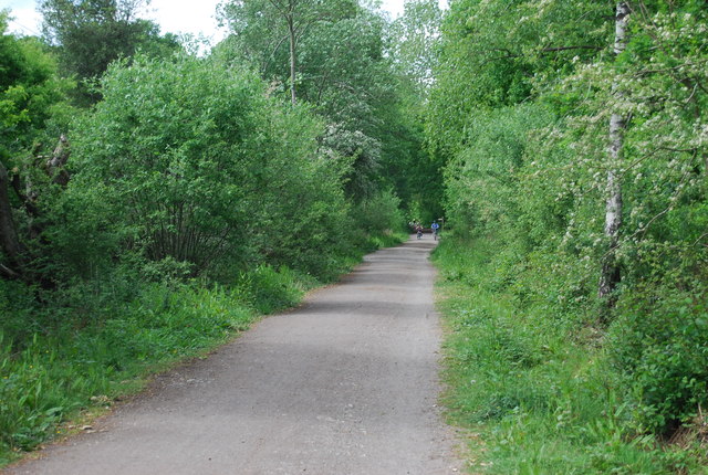
Visitors to Pondfarm Gill can explore the numerous walking trails that wind through the valley, allowing for immersive experiences in nature. The trails offer panoramic views of the surrounding countryside, with glimpses of the South Downs in the distance. Along the way, hikers may encounter charming wooden footbridges that span the gill, adding to the area's rustic charm.

The valley is also home to a diverse array of flora and fauna. Rare wildflowers, such as orchids and bluebells, can be found blooming during the spring and summer months. Additionally, the gill provides a habitat for a variety of bird species, including kingfishers and herons, which can often be spotted darting amongst the trees or wading in the shallow waters.

Overall, Pondfarm Gill is a hidden gem in Sussex, offering visitors a chance to immerse themselves in the tranquility of nature. With its stunning landscapes, diverse wildlife, and peaceful atmosphere, this valley is a must-visit destination for anyone seeking respite from the hustle and bustle of everyday life.

If you have any feedback on the listing, please let us know in the comments section below.

Pondfarm Gill Images

Images are sourced within 2km of 51.030027/-0.34688529 or Grid Reference TQ1626. Thanks to Geograph Open Source API. All images are credited.

Old Milestone by the former A24, Mill Straight, Southwater parish Carved stone post by the UC road (was A24), in parish of Southwater (Horsham District), Mill Straight, West of Fieldings, against fence, on South side of road at end of bus lay-by. Steyning stone, erected by the Horsham & Steyning turnpike trust in the 19th century. Painted and re-engraved by Lionel Joseph in about 2011.

Inscription reads:-
40
MILES
FROM
LONDON
Carved benchmark upper centre, rivet on top.

West Sussex HER.
HER Ref: MWS8538 <span class="nowrap"><a title="https://www.heritagegateway.org.uk/Gateway/Results_Single.aspx?uid=MWS8538&resourceID=1032" rel="nofollow ugc noopener" href="https://www.heritagegateway.org.uk/Gateway/Results_Single.aspx?uid=MWS8538&resourceID=1032">Link</a><img style="margin-left:2px;" alt="External link" title="External link - shift click to open in new window" src="https://s1.geograph.org.uk/img/external.png" width="10" height="10"/></span>

Milestone Society National ID: SX_LA40
Old Milestone by the former A24, Mill Straight, Southwater parish
Carved stone post by the UC road (was A24), in parish of Southwater (Horsham District), Mill Straight, West of Fieldings, against fence, on South side of road at end of bus lay-by. Steyning stone, erected by the Horsham & Steyning turnpike trust in the 19th century. Painted and re-engraved by Lionel Joseph in about 2011. Inscription reads:- 40 MILES FROM LONDON Carved benchmark upper centre, rivet on top. West Sussex HER. HER Ref: MWS8538 LinkExternal link Milestone Society National ID: SX_LA40
Godfreys of Horsham
Godfreys of Horsham
Downs Link The Downs Link is a 37-mile (59 km) footpath and bridleway linking the North Downs Way <a title="https://www.geograph.org.uk/snippet/174" href="https://www.geograph.org.uk/snippet/174">Link</a>  at St. Martha's Hill in Surrey with the South Downs Way <a title="https://www.geograph.org.uk/snippet/1186" href="https://www.geograph.org.uk/snippet/1186">Link</a>  near Steyning in West Sussex and on via the Coastal Link to Shoreham-by-Sea. Most of the route follows two dismantled railway lines, both closed by the Beeching cuts in the 1960s. The Shoreham-On-Sea to Christ’s Hospital line and the Christ’s Hospital to Shalford Junction line. The link opened in 1984. 
Cycle Route 223 follows the Downs link from Guildford to Shoreham.
The logo for the walk is the viaduct across the River Arun <a href="https://www.geograph.org.uk/photo/1870646">TQ0932 : Double Viaduct over the River Arun</a>.
A full history of the Cranleigh line (Christ’s Hospital to Shalford Junction) can be read at <span class="nowrap"><a title="http://en.wikipedia.org/wiki/Cranleigh_Line" rel="nofollow ugc noopener" href="http://en.wikipedia.org/wiki/Cranleigh_Line">Link</a><img style="margin-left:2px;" alt="External link" title="External link - shift click to open in new window" src="https://s1.geograph.org.uk/img/external.png" width="10" height="10"/></span>
Downs Link
The Downs Link is a 37-mile (59 km) footpath and bridleway linking the North Downs Way Link at St. Martha's Hill in Surrey with the South Downs Way Link near Steyning in West Sussex and on via the Coastal Link to Shoreham-by-Sea. Most of the route follows two dismantled railway lines, both closed by the Beeching cuts in the 1960s. The Shoreham-On-Sea to Christ’s Hospital line and the Christ’s Hospital to Shalford Junction line. The link opened in 1984. Cycle Route 223 follows the Downs link from Guildford to Shoreham. The logo for the walk is the viaduct across the River Arun TQ0932 : Double Viaduct over the River Arun. A full history of the Cranleigh line (Christ’s Hospital to Shalford Junction) can be read at LinkExternal link
Footpath signpost, Downs Link The Downs Link is a 37-mile (59 km) footpath and bridleway linking the North Downs Way <a title="https://www.geograph.org.uk/snippet/174" href="https://www.geograph.org.uk/snippet/174">Link</a>  at St. Martha's Hill in Surrey with the South Downs Way <a title="https://www.geograph.org.uk/snippet/1186" href="https://www.geograph.org.uk/snippet/1186">Link</a>  near Steyning in West Sussex and on via the Coastal Link to Shoreham-by-Sea. Most of the route follows two dismantled railway lines, both closed by the Beeching cuts in the 1960s. The Shoreham-On-Sea to Christ’s Hospital line and the Christ’s Hospital to Shalford Junction line. The link opened in 1984. 
Cycle Route 223 follows the Downs link from Guildford to Shoreham.
The logo for the walk is the viaduct across the River Arun <a href="https://www.geograph.org.uk/photo/1870646">TQ0932 : Double Viaduct over the River Arun</a>.
A full history of the Cranleigh line (Christ’s Hospital to Shalford Junction) can be read at <span class="nowrap"><a title="http://en.wikipedia.org/wiki/Cranleigh_Line" rel="nofollow ugc noopener" href="http://en.wikipedia.org/wiki/Cranleigh_Line">Link</a><img style="margin-left:2px;" alt="External link" title="External link - shift click to open in new window" src="https://s1.geograph.org.uk/img/external.png" width="10" height="10"/></span>
Footpath signpost, Downs Link
The Downs Link is a 37-mile (59 km) footpath and bridleway linking the North Downs Way Link at St. Martha's Hill in Surrey with the South Downs Way Link near Steyning in West Sussex and on via the Coastal Link to Shoreham-by-Sea. Most of the route follows two dismantled railway lines, both closed by the Beeching cuts in the 1960s. The Shoreham-On-Sea to Christ’s Hospital line and the Christ’s Hospital to Shalford Junction line. The link opened in 1984. Cycle Route 223 follows the Downs link from Guildford to Shoreham. The logo for the walk is the viaduct across the River Arun TQ0932 : Double Viaduct over the River Arun. A full history of the Cranleigh line (Christ’s Hospital to Shalford Junction) can be read at LinkExternal link
Footpath into Nutham Wood
Downs Link, Nutham Wood The Downs Link is a 37-mile (59 km) footpath and bridleway linking the North Downs Way <a title="https://www.geograph.org.uk/snippet/174" href="https://www.geograph.org.uk/snippet/174">Link</a>  at St. Martha's Hill in Surrey with the South Downs Way <a title="https://www.geograph.org.uk/snippet/1186" href="https://www.geograph.org.uk/snippet/1186">Link</a>  near Steyning in West Sussex and on via the Coastal Link to Shoreham-by-Sea. Most of the route follows two dismantled railway lines, both closed by the Beeching cuts in the 1960s. The Shoreham-On-Sea to Christ’s Hospital line and the Christ’s Hospital to Shalford Junction line. The link opened in 1984. 
Cycle Route 223 follows the Downs link from Guildford to Shoreham.
The logo for the walk is the viaduct across the River Arun <a href="https://www.geograph.org.uk/photo/1870646">TQ0932 : Double Viaduct over the River Arun</a>.
A full history of the Cranleigh line (Christ’s Hospital to Shalford Junction) can be read at <span class="nowrap"><a title="http://en.wikipedia.org/wiki/Cranleigh_Line" rel="nofollow ugc noopener" href="http://en.wikipedia.org/wiki/Cranleigh_Line">Link</a><img style="margin-left:2px;" alt="External link" title="External link - shift click to open in new window" src="https://s1.geograph.org.uk/img/external.png" width="10" height="10"/></span>
Downs Link, Nutham Wood
The Downs Link is a 37-mile (59 km) footpath and bridleway linking the North Downs Way Link at St. Martha's Hill in Surrey with the South Downs Way Link near Steyning in West Sussex and on via the Coastal Link to Shoreham-by-Sea. Most of the route follows two dismantled railway lines, both closed by the Beeching cuts in the 1960s. The Shoreham-On-Sea to Christ’s Hospital line and the Christ’s Hospital to Shalford Junction line. The link opened in 1984. Cycle Route 223 follows the Downs link from Guildford to Shoreham. The logo for the walk is the viaduct across the River Arun TQ0932 : Double Viaduct over the River Arun. A full history of the Cranleigh line (Christ’s Hospital to Shalford Junction) can be read at LinkExternal link
Bench by the Downs Link The Downs Link is a 37-mile (59 km) footpath and bridleway linking the North Downs Way <a title="https://www.geograph.org.uk/snippet/174" href="https://www.geograph.org.uk/snippet/174">Link</a>  at St. Martha's Hill in Surrey with the South Downs Way <a title="https://www.geograph.org.uk/snippet/1186" href="https://www.geograph.org.uk/snippet/1186">Link</a>  near Steyning in West Sussex and on via the Coastal Link to Shoreham-by-Sea. Most of the route follows two dismantled railway lines, both closed by the Beeching cuts in the 1960s. The Shoreham-On-Sea to Christ’s Hospital line and the Christ’s Hospital to Shalford Junction line. The link opened in 1984. 
Cycle Route 223 follows the Downs link from Guildford to Shoreham.
The logo for the walk is the viaduct across the River Arun <a href="https://www.geograph.org.uk/photo/1870646">TQ0932 : Double Viaduct over the River Arun</a>.
A full history of the Cranleigh line (Christ’s Hospital to Shalford Junction) can be read at <span class="nowrap"><a title="http://en.wikipedia.org/wiki/Cranleigh_Line" rel="nofollow ugc noopener" href="http://en.wikipedia.org/wiki/Cranleigh_Line">Link</a><img style="margin-left:2px;" alt="External link" title="External link - shift click to open in new window" src="https://s1.geograph.org.uk/img/external.png" width="10" height="10"/></span>
Bench by the Downs Link
The Downs Link is a 37-mile (59 km) footpath and bridleway linking the North Downs Way Link at St. Martha's Hill in Surrey with the South Downs Way Link near Steyning in West Sussex and on via the Coastal Link to Shoreham-by-Sea. Most of the route follows two dismantled railway lines, both closed by the Beeching cuts in the 1960s. The Shoreham-On-Sea to Christ’s Hospital line and the Christ’s Hospital to Shalford Junction line. The link opened in 1984. Cycle Route 223 follows the Downs link from Guildford to Shoreham. The logo for the walk is the viaduct across the River Arun TQ0932 : Double Viaduct over the River Arun. A full history of the Cranleigh line (Christ’s Hospital to Shalford Junction) can be read at LinkExternal link
Downs Link in Nutham Wood
Nutham Wood
Nutham Wood
Nutham Wood
Nutham Wood
Footpath sign, Nutham Wood
Sewage farm building
Signpost, Downs Link The Downs Link is a 37-mile (59 km) footpath and bridleway linking the North Downs Way <a title="https://www.geograph.org.uk/snippet/174" href="https://www.geograph.org.uk/snippet/174">Link</a>  at St. Martha's Hill in Surrey with the South Downs Way <a title="https://www.geograph.org.uk/snippet/1186" href="https://www.geograph.org.uk/snippet/1186">Link</a>  near Steyning in West Sussex and on via the Coastal Link to Shoreham-by-Sea. Most of the route follows two dismantled railway lines, both closed by the Beeching cuts in the 1960s. The Shoreham-On-Sea to Christ’s Hospital line and the Christ’s Hospital to Shalford Junction line. The link opened in 1984. 
Cycle Route 223 follows the Downs link from Guildford to Shoreham.
The logo for the walk is the viaduct across the River Arun <a href="https://www.geograph.org.uk/photo/1870646">TQ0932 : Double Viaduct over the River Arun</a>.
A full history of the Cranleigh line (Christ’s Hospital to Shalford Junction) can be read at <span class="nowrap"><a title="http://en.wikipedia.org/wiki/Cranleigh_Line" rel="nofollow ugc noopener" href="http://en.wikipedia.org/wiki/Cranleigh_Line">Link</a><img style="margin-left:2px;" alt="External link" title="External link - shift click to open in new window" src="https://s1.geograph.org.uk/img/external.png" width="10" height="10"/></span>
Signpost, Downs Link
The Downs Link is a 37-mile (59 km) footpath and bridleway linking the North Downs Way Link at St. Martha's Hill in Surrey with the South Downs Way Link near Steyning in West Sussex and on via the Coastal Link to Shoreham-by-Sea. Most of the route follows two dismantled railway lines, both closed by the Beeching cuts in the 1960s. The Shoreham-On-Sea to Christ’s Hospital line and the Christ’s Hospital to Shalford Junction line. The link opened in 1984. Cycle Route 223 follows the Downs link from Guildford to Shoreham. The logo for the walk is the viaduct across the River Arun TQ0932 : Double Viaduct over the River Arun. A full history of the Cranleigh line (Christ’s Hospital to Shalford Junction) can be read at LinkExternal link
Downs Link
Downs Link
Downs Link under the A24 The Downs Link is a 37-mile (59 km) footpath and bridleway linking the North Downs Way <a title="https://www.geograph.org.uk/snippet/174" href="https://www.geograph.org.uk/snippet/174">Link</a>  at St. Martha's Hill in Surrey with the South Downs Way <a title="https://www.geograph.org.uk/snippet/1186" href="https://www.geograph.org.uk/snippet/1186">Link</a>  near Steyning in West Sussex and on via the Coastal Link to Shoreham-by-Sea. Most of the route follows two dismantled railway lines, both closed by the Beeching cuts in the 1960s. The Shoreham-On-Sea to Christ’s Hospital line and the Christ’s Hospital to Shalford Junction line. The link opened in 1984. 
Cycle Route 223 follows the Downs link from Guildford to Shoreham.
The logo for the walk is the viaduct across the River Arun <a href="https://www.geograph.org.uk/photo/1870646">TQ0932 : Double Viaduct over the River Arun</a>.
A full history of the Cranleigh line (Christ’s Hospital to Shalford Junction) can be read at <span class="nowrap"><a title="http://en.wikipedia.org/wiki/Cranleigh_Line" rel="nofollow ugc noopener" href="http://en.wikipedia.org/wiki/Cranleigh_Line">Link</a><img style="margin-left:2px;" alt="External link" title="External link - shift click to open in new window" src="https://s1.geograph.org.uk/img/external.png" width="10" height="10"/></span>
Downs Link under the A24
The Downs Link is a 37-mile (59 km) footpath and bridleway linking the North Downs Way Link at St. Martha's Hill in Surrey with the South Downs Way Link near Steyning in West Sussex and on via the Coastal Link to Shoreham-by-Sea. Most of the route follows two dismantled railway lines, both closed by the Beeching cuts in the 1960s. The Shoreham-On-Sea to Christ’s Hospital line and the Christ’s Hospital to Shalford Junction line. The link opened in 1984. Cycle Route 223 follows the Downs link from Guildford to Shoreham. The logo for the walk is the viaduct across the River Arun TQ0932 : Double Viaduct over the River Arun. A full history of the Cranleigh line (Christ’s Hospital to Shalford Junction) can be read at LinkExternal link
Show me another place!

Pondfarm Gill is located at Grid Ref: TQ1626 (Lat: 51.030027, Lng: -0.34688529)

Administrative County: West Sussex

District: Horsham

Police Authority: Sussex

What 3 Words

///snap.wordplay.incorrect. Near Southwater, West Sussex

Related Wikis

Southwater railway station

Southwater was a railway station on the Steyning Line which served the village of Southwater. A goods siding allowed for the transportation of coal and...

Southwater

Southwater is a large village and civil parish in the Horsham District of West Sussex, England, with a population of roughly 10,000. It is administered...

Holy Innocents Church, Southwater

Holy Innocents Church is the Anglican parish church of Southwater, a village in the Horsham District of West Sussex, England. Built in 1849, the church...

Downs Link

The Downs Link is a 36.7 miles (59.1 km) path and bridleway linking the North Downs Way at St. Martha's Hill in Surrey with the South Downs Way near Steyning...

Haywards Heath Town F.C. Women

Haywards Heath Town F.C. Women (formerly Crawley Wasps Ladies FC) is an English women's football club, that currently plays in the FA Women's National...

Copthorne F.C.

Copthorne Football Club is a football club based in Copthorne in West Sussex, England. They are currently members of the Southern Combination Division...

Horsham F.C.

Horsham Football Club is a non-League football club based in Horsham, West Sussex, England, currently playing in the Isthmian League Premier Division....

Christ's Hospital

Christ's Hospital is a public school (English fee-charging boarding school for pupils aged 11–18) with a royal charter located to the south of Horsham...

Nearby Amenities

Located within 500m of 51.030027,-0.34688529
Post Box
Operator: Royal Mail
Operator Wikidata: Q638098
Ref: RH13 243
Lat/Long: 51.0327429/-0.3420991
Leisure: playground
Lat/Long: 51.0307374/-0.345591
Mini Roundabout
Direction: clockwise
Lat/Long: 51.030036/-0.3434747
Turning Circle
Lat/Long: 51.0281649/-0.3467796
Access: yes
Leisure: playground
Lat/Long: 51.0291025/-0.3483498
Bus Stop
Roundstone Caravan Park
Bus: yes
Naptan AtcoCode: 4400HO0013
Naptan Bearing: S
Naptan CommonName: Roundstone Caravan Park
Naptan Indicator: o/s
Naptan Landmark: Green Close
Naptan NaptanCode: wsxapmdw
Naptan ShortCommonName: R'stone Caravan Pk
Naptan Street: Worthing Road
Naptan Verified: no
Public Transport: platform
Source: naptan_import
Lat/Long: 51.0316192/-0.3517625
Bus Stop
Roundstone Caravan Park
Bus: yes
Naptan AtcoCode: 4400HO0014
Naptan Bearing: N
Naptan CommonName: Roundstone Caravan Park
Naptan Indicator: opp
Naptan Landmark: Green Close
Naptan NaptanCode: wsxapmga
Naptan ShortCommonName: R'stone Caravan Pk
Naptan Street: Worthing Road
Naptan Verified: no
Public Transport: platform
Source: naptan_import
Lat/Long: 51.0316404/-0.3519239
Bus Stop
Camelot Close
Bench: no
Bin: no
Bus: yes
Lit: yes
Naptan AtcoCode: 4400HO0021
Naptan Bearing: S
Naptan CommonName: Camelot Close
Naptan Indicator: adj Camelot Close
Naptan Landmark: Camelot Close
Naptan NaptanCode: wsxapmja
Naptan Street: Cedar Drive
Naptan Verified: no
Public Transport: platform
Shelter: no
Source: naptan_import
Tactile Paving: no
Lat/Long: 51.0270767/-0.342672
Bus Stop
The Copse
Bus: yes
Naptan AtcoCode: 4400HO0023
Naptan Bearing: NW
Naptan CommonName: The Copse
Naptan Indicator: opp. The Copse
Naptan Landmark: The Copse
Naptan NaptanCode: wsxapmjg
Naptan Street: Cedar Drive
Naptan Verified: no
Public Transport: platform
Source: naptan_import
Lat/Long: 51.0295735/-0.350658
Bus Stop
The Copse
Bus: yes
Naptan AtcoCode: 4400HO0226
Naptan Bearing: SE
Naptan CommonName: The Copse
Naptan Indicator: Opp 15
Naptan Landmark: The Copse
Naptan NaptanCode: wsxatdad
Naptan Street: Cedar Drive
Naptan Verified: no
Public Transport: platform
Source: naptan_import
Lat/Long: 51.0300386/-0.3512467
Bus Stop
The Brook
Bench: no
Bin: no
Bus: yes
Lit: yes
Naptan AtcoCode: 4400HO0300
Naptan Bearing: SE
Naptan CommonName: The Brook
Naptan Indicator: Bridge
Naptan Landmark: the Brook
Naptan NaptanCode: wsxatdpg
Naptan Street: Cedar Drive
Naptan Verified: no
Public Transport: platform
Shelter: no
Source: naptan_import
Tactile Paving: no
Lat/Long: 51.029083/-0.3472493
Turning Circle
Lat/Long: 51.0262371/-0.3466499
Turning Circle
Lat/Long: 51.0257997/-0.3458708
Turning Circle
Lat/Long: 51.0262624/-0.3475686
Turning Circle
Lat/Long: 51.0276145/-0.34724
Turning Circle
Lat/Long: 51.027431/-0.3461759
Turning Circle
Lat/Long: 51.0267348/-0.3438235
Traffic Calming: hump
Lat/Long: 51.0296063/-0.3505782
Traffic Calming: hump
Lat/Long: 51.0300501/-0.3514517
Barrier: stile
Lat/Long: 51.0330126/-0.3519521
Crossing
Crossing: zebra
Lat/Long: 51.028415/-0.3522964
Crossing
Crossing: zebra
Lat/Long: 51.0275992/-0.3523008
Noexit: yes
Lat/Long: 51.0267506/-0.3463952
Noexit: yes
Lat/Long: 51.027891/-0.3462343
The data included in this document is from www.openstreetmap.org. The data is made available under ODbL.

Have you been to Pondfarm Gill?

Leave your review of Pondfarm Gill below (or comments, questions and feedback).