Beechen Bottom

Valley in Hertfordshire Three Rivers

England

Beechen Bottom

Grand Union Canal, Hunton Bridge The canal is wide enough to take boats wider than the standard "narrow" boat. Facing towards Watford.
Grand Union Canal, Hunton Bridge Credit: Jack Hill

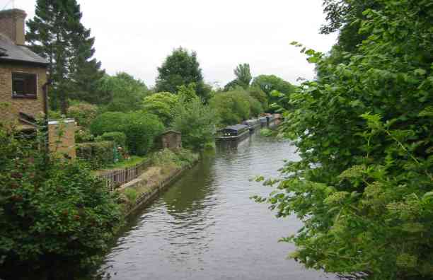
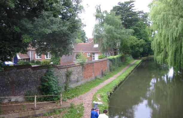
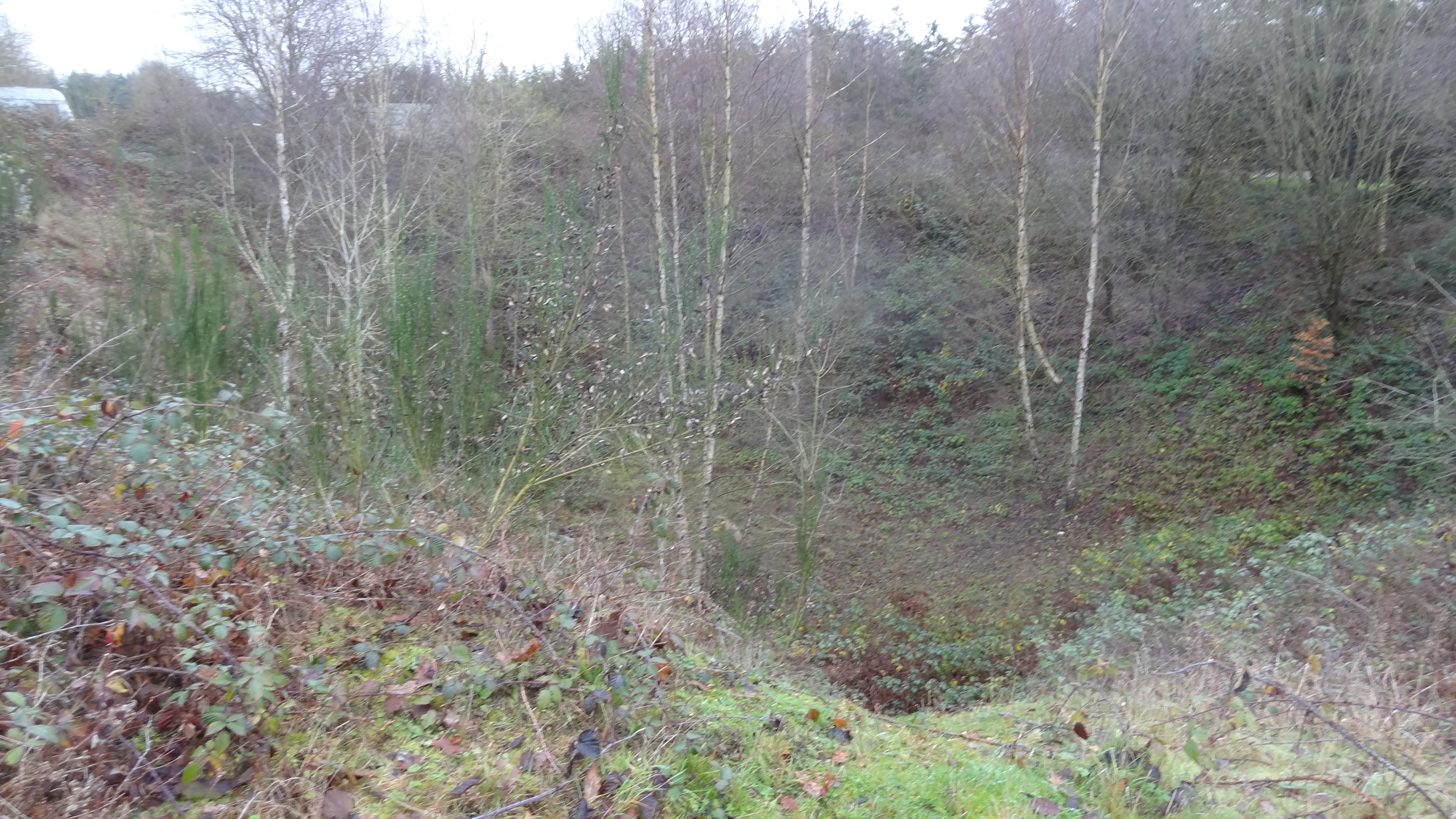
Beechen Bottom is a picturesque valley located in Hertfordshire, England. Nestled amidst rolling hills and lush greenery, this tranquil spot offers a serene retreat for nature enthusiasts and outdoor lovers. The valley is situated approximately 30 miles north of London and covers a vast area of scenic beauty.

One of the defining features of Beechen Bottom is its diverse range of flora and fauna. The valley is home to a variety of tree species, including beech trees, which give the area its name. The dense woodland provides a haven for numerous bird species, making it an ideal spot for birdwatching. Additionally, the valley is known for its wildflowers that bloom in abundance during the spring and summer months, adding bursts of vibrant colors to the landscape.

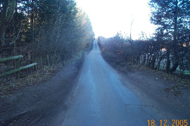
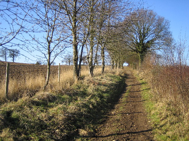
Beechen Bottom is crisscrossed by a network of walking trails, making it a popular destination for hikers and nature walkers. The paths wind through the valley, offering stunning views of the surrounding countryside and allowing visitors to immerse themselves in the peaceful ambiance. The valley also features a small stream that meanders through its heart, creating a soothing soundtrack to accompany the scenic beauty.

For those seeking a quiet picnic spot or a place to simply relax and unwind, Beechen Bottom provides ample space and tranquility. The valley's idyllic setting makes it a favorite spot for families and friends to gather and enjoy the great outdoors.

Overall, Beechen Bottom is a hidden gem in Hertfordshire, offering a peaceful escape from the hustle and bustle of urban life. With its lush landscapes, diverse wildlife, and abundance of walking trails, this valley provides a perfect retreat for nature lovers and anyone seeking a respite in the lap of nature.

If you have any feedback on the listing, please let us know in the comments section below.

Beechen Bottom Images

Images are sourced within 2km of 51.685893/-0.45305707 or Grid Reference TQ0799. Thanks to Geograph Open Source API. All images are credited.

Grand Union Canal, Hunton Bridge The canal is wide enough to take boats wider than the standard "narrow" boat. Facing towards Watford.
Grand Union Canal, Hunton Bridge
The canal is wide enough to take boats wider than the standard "narrow" boat. Facing towards Watford.
Canal at Hunton Bridge This view is looking north. The building on the left used to be a school and is now office accommodation called "The Old Schoolhouse".
Canal at Hunton Bridge
This view is looking north. The building on the left used to be a school and is now office accommodation called "The Old Schoolhouse".
Watford: The Grove Mill The former mill building in Grove Mill Lane now converted into residential use.
Watford: The Grove Mill
The former mill building in Grove Mill Lane now converted into residential use.
Sarratt: Buckshill Bottom valley A dry valley viewed looking eastwards from a footpath to Newhall Farm near Sarratt.
Sarratt: Buckshill Bottom valley
A dry valley viewed looking eastwards from a footpath to Newhall Farm near Sarratt.
Chandler's Cross: Fir Tree Hill Fir Tree Hill is the name of the road, viewed looking westwards towards Chandler's Cross.
Chandler's Cross: Fir Tree Hill
Fir Tree Hill is the name of the road, viewed looking westwards towards Chandler's Cross.
M25 Motorway Link Road, Chandler's Cross This is the spur road leading to Junction 19 of the M25 Motorway from the Hunton Bridge roundabout, viewed looking westwards from the Langleybury Lane overbridge. Traffic is usually stationary westbound on this stretch during the weekday morning rush hour, but the road is virtually deserted on a Sunday morning. This particular road existed as the A405 trunk road, by-passing Watford, for many years prior to the M25 being built, and the route of the A405 was also incorporated into the motorway from Junction 19 to Junction 17 at Maple Cross. The distant dark triangular shaped structure is the gantry holding a conveyor belt crossing the road, associated with the numerous gravel pit workings in the vicinity.
M25 Motorway Link Road, Chandler's Cross
This is the spur road leading to Junction 19 of the M25 Motorway from the Hunton Bridge roundabout, viewed looking westwards from the Langleybury Lane overbridge. Traffic is usually stationary westbound on this stretch during the weekday morning rush hour, but the road is virtually deserted on a Sunday morning. This particular road existed as the A405 trunk road, by-passing Watford, for many years prior to the M25 being built, and the route of the A405 was also incorporated into the motorway from Junction 19 to Junction 17 at Maple Cross. The distant dark triangular shaped structure is the gantry holding a conveyor belt crossing the road, associated with the numerous gravel pit workings in the vicinity.
Chandler's Cross: Oldhouse Lane Viewed looking westwards up Juniper Hill from Beechen Bottom.
Chandler's Cross: Oldhouse Lane
Viewed looking westwards up Juniper Hill from Beechen Bottom.
M25 Motorway, Chandler's Cross Viewed looking south westwards from the Chandler's Lane overbridge.
M25 Motorway, Chandler's Cross
Viewed looking south westwards from the Chandler's Lane overbridge.
Chipperfield: Bridleway between Hunton Bridge and Bucks Hill Viewed looking westwards.
Chipperfield: Bridleway between Hunton Bridge and Bucks Hill
Viewed looking westwards.
Chipperfield: Bridleway between Hunton Bridge and Bucks Hill Viewed looking northwards up the dry valley.
Chipperfield: Bridleway between Hunton Bridge and Bucks Hill
Viewed looking northwards up the dry valley.
Kings Langley: Langley Lodge Lane Viewed looking eastwards with Sunbury Hill Farm to the left.
Kings Langley: Langley Lodge Lane
Viewed looking eastwards with Sunbury Hill Farm to the left.
Hunton Bridge: Farmland Viewed looking east from the south west corner of the grid square.
Hunton Bridge: Farmland
Viewed looking east from the south west corner of the grid square.
Hunton Bridge: Farmland Viewed looking south from the north west corner of the grid square.
Hunton Bridge: Farmland
Viewed looking south from the north west corner of the grid square.
Hunton Bridge: St Paul's Church, Langleybury Located on Langleybury Lane at its junction with the A41.
Hunton Bridge: St Paul's Church, Langleybury
Located on Langleybury Lane at its junction with the A41.
Grand Union Canal, near Watford Looking north from Lady Capel's Lock. The M25 bridge is just beyond this stretch.
Grand Union Canal, near Watford
Looking north from Lady Capel's Lock. The M25 bridge is just beyond this stretch.
The Grove Bridge, Grand Union Canal The Earl of Clarendon insisted on an elegant bridge when the canal was routed across his land. The bridge was restored in 1987 by the Railway Heritage Trust, British Waterways Board, and British Rail Property Board.
The Grove Bridge, Grand Union Canal
The Earl of Clarendon insisted on an elegant bridge when the canal was routed across his land. The bridge was restored in 1987 by the Railway Heritage Trust, British Waterways Board, and British Rail Property Board.
The Grove and golf course, Watford The Grove is now a hotel and golf course. It was bought in 1753 by Thomas Villiers, who became 1st Earl of Clarendon. It has been a school, and a training centre for British Rail.
The Grove and golf course, Watford
The Grove is now a hotel and golf course. It was bought in 1753 by Thomas Villiers, who became 1st Earl of Clarendon. It has been a school, and a training centre for British Rail.
Clarendon Park Farm, Watford View west from the Grand Union Canal across The Grove golf course.
Clarendon Park Farm, Watford
View west from the Grand Union Canal across The Grove golf course.
Show me another place!

Beechen Bottom is located at Grid Ref: TQ0799 (Lat: 51.685893, Lng: -0.45305707)

Administrative County: Hertfordshire

District: Three Rivers

Police Authority: Hertfordshire

What 3 Words

///banks.emerge.crazy. Near Kings Langley, Hertfordshire

Nearby Locations

Beechen Bottom

Related Wikis

Westwood Quarry

Westwood Quarry is a 0.07 hectares (0.17 acres) geological site of Special Scientific Interest west of Watford in Hertfordshire. It was notified in 1987...

Langleybury

Langleybury is a country house and estate in Abbots Langley, Hertfordshire, England, about 3 miles (5 km) northwest of the centre of the town of Watford...

The Grove, Watford

The Grove is a large hotel in Hertfordshire, England, with a 300–acre (1.2 km2) private park next to the River Gade and the Grand Union Canal. It touches...

Hunton Bridge

Hunton Bridge is a small settlement near Abbots Langley, Hertfordshire, England, with a historic royal connection. Its population in the 1991 census was...

Whippendell Wood

Whippendell Wood (or Whippendell Woods) is an ancient woodland on the edges of Watford, England, covering an area of 165.3 acres (66.9 ha). It is owned...

Hunton Park

Hunton Park is a large country house and estate in Abbots Langley, in south west Hertfordshire, in the United Kingdom. It was originally called Hazelwood...

Sarratt

Sarratt is both a village and a civil parish in Three Rivers District, Hertfordshire, England. It is situated 4 miles (6.4 km) north of Rickmansworth...

Warner Bros. Studios, Leavesden

Warner Bros. Studios, Leavesden is an 80 ha (200-acre) studio complex in Leavesden in Watford, Hertfordshire, in the East of England. Formerly known as...

Nearby Amenities

Located within 500m of 51.685893,-0.45305707
Phone
Emergency: phone
Operator: National Highways
Operator Wikidata: Q5760006
Lat/Long: 51.6884/-0.4473598
Speed Camera
Lat/Long: 51.683507/-0.4492418
Phone
Emergency: phone
Operator: National Highways
Operator Wikidata: Q5760006
Lat/Long: 51.6830349/-0.4488905
Traffic Sign: variable_message
Variable Message Model: MS2
Lat/Long: 51.6833186/-0.448663
Traffic Sign: variable_message
Variable Message Model: AMI
Lat/Long: 51.683338/-0.4487224
Traffic Sign: variable_message
Variable Message Model: AMI
Lat/Long: 51.683353/-0.4487687
Traffic Sign: variable_message
Variable Message Model: AMI
Lat/Long: 51.6833679/-0.4488143
Traffic Sign: variable_message
Variable Message Model: AMI
Lat/Long: 51.6833823/-0.4488584
Camera Mount: pole
Camera Type: panning
Man Made: surveillance
Operator: National Highways
Operator Wikidata: Q5760006
Surveillance: outdoor
Surveillance Type: camera
Surveillance Zone: traffic
Lat/Long: 51.6832615/-0.4486578
Phone
Emergency: phone
Operator: National Highways
Operator Wikidata: Q5760006
Lat/Long: 51.6828362/-0.4498145
Traffic Sign: variable_message
Variable Message Model: AMI
Lat/Long: 51.6834167/-0.4489642
Traffic Sign: variable_message
Variable Message Model: AMI
Lat/Long: 51.6834309/-0.449008
Traffic Sign: variable_message
Variable Message Model: AMI
Lat/Long: 51.6834487/-0.4490624
Traffic Sign: variable_message
Variable Message Model: AMI
Lat/Long: 51.683464/-0.4491094
Traffic Sign: variable_message
Variable Message Model: MS2
Lat/Long: 51.6834836/-0.4491697
Street Lamp
Lat/Long: 51.683097/-0.4487799
Street Lamp
Lat/Long: 51.6832991/-0.449386
Street Lamp
Lat/Long: 51.6834787/-0.4484889
Street Lamp
Lat/Long: 51.6836608/-0.4490789
Street Lamp
Lat/Long: 51.683842/-0.4482112
Street Lamp
Lat/Long: 51.6840116/-0.4488214
Street Lamp
Lat/Long: 51.6842262/-0.4479511
Street Lamp
Lat/Long: 51.6843729/-0.4485608
Street Lamp
Lat/Long: 51.6846111/-0.4477258
Street Lamp
Lat/Long: 51.6847471/-0.4483269
Street Lamp
Lat/Long: 51.6849936/-0.4475045
Street Lamp
Lat/Long: 51.6851192/-0.4481214
Street Lamp
Lat/Long: 51.685407/-0.4473326
Street Lamp
Lat/Long: 51.6855063/-0.4479426
Street Lamp
Lat/Long: 51.6858884/-0.4470969
Street Lamp
Lat/Long: 51.6859772/-0.4477824
Street Lamp
Lat/Long: 51.6866056/-0.4468766
Street Lamp
Lat/Long: 51.6866629/-0.4475575
Street Lamp
Lat/Long: 51.687023/-0.4468026
Street Lamp
Lat/Long: 51.6870583/-0.447482
Street Lamp
Lat/Long: 51.6874308/-0.4467626
Street Lamp
Lat/Long: 51.6874576/-0.4474327
Street Lamp
Lat/Long: 51.6878484/-0.4473892
Street Lamp
Lat/Long: 51.6878359/-0.4467133
Street Lamp
Lat/Long: 51.6882338/-0.4473603
Street Lamp
Lat/Long: 51.6816569/-0.4511586
Street Lamp
Lat/Long: 51.6819778/-0.4507768
Street Lamp
Lat/Long: 51.6820618/-0.449838
Street Lamp
Lat/Long: 51.6822971/-0.4504026
Street Lamp
Lat/Long: 51.6824044/-0.4494518
Street Lamp
Lat/Long: 51.6826222/-0.4500579
Street Lamp
Lat/Long: 51.6827478/-0.4491138
Street Lamp
Lat/Long: 51.6829714/-0.4496999
Street Lamp
Lat/Long: 51.6886531/-0.4473461
The data included in this document is from www.openstreetmap.org. The data is made available under ODbL.

Have you been to Beechen Bottom?

Leave your review of Beechen Bottom below (or comments, questions and feedback).