Brockhurst Bottom

Valley in Sussex Chichester

England

Brockhurst Bottom

Sheep and horses by Dirty Lane, Graffham Dirty Lane is public bridleway 954, Graffham.
Sheep and horses by Dirty Lane, Graffham Credit: Robin Webster

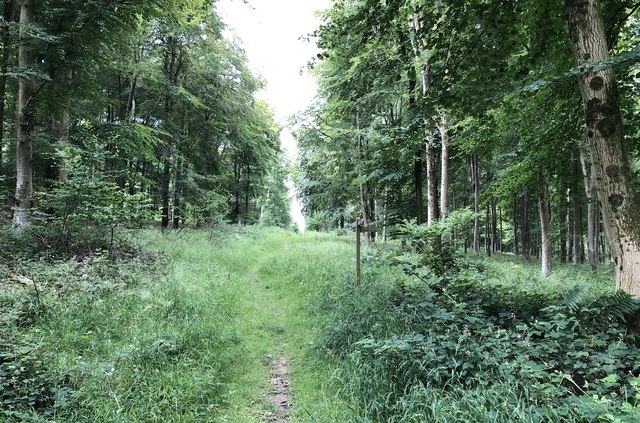
Brockhurst Bottom is a picturesque valley located in the county of Sussex, England. Situated in the South Downs National Park, it is nestled between the villages of East Dean and Friston, offering visitors a tranquil and idyllic setting for nature lovers and outdoor enthusiasts alike.

The valley is characterized by its rolling hills, lush green meadows, and woodland areas, providing a diverse habitat for a wide range of flora and fauna. The area is particularly known for its rich biodiversity, with several rare and protected species of plants and animals calling it home.

The valley is crisscrossed by a network of footpaths and trails, making it a popular destination for walkers, hikers, and cyclists. These paths offer breathtaking views of the surrounding countryside, and visitors can explore the valley at their own pace, immersing themselves in the beauty of the natural landscape.

Brockhurst Bottom is also renowned for its historical significance, with traces of human activity dating back centuries. Ancient burial mounds and archaeological sites can be found throughout the valley, providing a glimpse into the area's past.

For those seeking a peaceful retreat, Brockhurst Bottom offers a sense of tranquility and serenity, away from the hustle and bustle of city life. Whether it's a leisurely stroll, a picnic in the meadows, or simply soaking in the natural beauty, this hidden gem in Sussex is a haven for anyone looking to reconnect with nature.

If you have any feedback on the listing, please let us know in the comments section below.

Brockhurst Bottom Images

Images are sourced within 2km of 50.927845/-0.69856795 or Grid Reference SU9115. Thanks to Geograph Open Source API. All images are credited.

Sheep and horses by Dirty Lane, Graffham Dirty Lane is public bridleway 954, Graffham.
Sheep and horses by Dirty Lane, Graffham
Dirty Lane is public bridleway 954, Graffham.
Searching southwards down the Bashire (18) A peaceful scene in Eastdean Wood
Searching southwards down the Bashire (18)
A peaceful scene in Eastdean Wood
Searching southwards down the Bashire (19) Road from Pond Barn, looking towards Newhouse Farm
Searching southwards down the Bashire (19)
Road from Pond Barn, looking towards Newhouse Farm
Searching southwards down the Bashire (20) Seen at New Barn
I have set myself a totemic challenge!
Searching southwards down the Bashire (20)
Seen at New Barn I have set myself a totemic challenge!
Field north of East Dean
Woods on summit of Court Hill
Field north of East Dean
Farm tack on High Down From Droke Lane.
Farm tack on High Down
From Droke Lane.
Crops on south slope of High Down Looking towards East Dean.
Crops on south slope of High Down
Looking towards East Dean.
Path beside field on Court Hill
Field on Court Hill
Field on Court Hill
Tumuli beside the South Downs Way Ancient burial mounds close to the National Trail.
Tumuli beside the South Downs Way
Ancient burial mounds close to the National Trail.
Track near Grass Tegleaze Heading northwards in the direction of the South Downs Way.
Track near Grass Tegleaze
Heading northwards in the direction of the South Downs Way.
Path junction at Tegleaze One of the many tracks passing through the woodland at Tegleaze.
Path junction at Tegleaze
One of the many tracks passing through the woodland at Tegleaze.
Joining New Road Approaching the forest track known as New Road.
Joining New Road
Approaching the forest track known as New Road.
Path junction near Ripshook On the track heading towards Shepherd’s Croft at the point where a footpath breaks off to the left. A bridleway sign is almost completely obscured by bracken.
Path junction near Ripshook
On the track heading towards Shepherd’s Croft at the point where a footpath breaks off to the left. A bridleway sign is almost completely obscured by bracken.
Kink in the South Downs Way At this point the OS Map shows that the route of the South Downs Way turns left through the gate. It then heads north for a short distance before resuming its easterly direction.  However, the route ahead provides a short cycle route to seemingly avoid having to use the gate, but is probably used by all users of the trail.
Kink in the South Downs Way
At this point the OS Map shows that the route of the South Downs Way turns left through the gate. It then heads north for a short distance before resuming its easterly direction. However, the route ahead provides a short cycle route to seemingly avoid having to use the gate, but is probably used by all users of the trail.
Show me another place!

Brockhurst Bottom is located at Grid Ref: SU9115 (Lat: 50.927845, Lng: -0.69856795)

Administrative County: West Sussex

District: Chichester

Police Authority: Sussex

What 3 Words

///loopholes.firework.toffee. Near Midhurst, West Sussex

Related Wikis

Sussex Downs AONB

Sussex Downs Area of Outstanding Natural Beauty in England was designated in 1966. The designation was revoked in March 2010, together with the neighbouring...

East Dean, West Sussex

East Dean is a village and civil parish in the District of Chichester in West Sussex, England. The village is in a valley in the South Downs, 5+1⁄2 miles...

Heyshott Down

Heyshott Down is a 42.6-hectare (105-acre) biological Site of Special Scientific Interest south of Midhurst in West Sussex. It is a Nature Conservation...

Graffham

Graffham is a village, Anglican parish and civil parish in West Sussex, England, situated on the northern escarpment of the South Downs within the South...

Nearby Amenities

Located within 500m of 50.927845,-0.69856795
Barrier: stile
Lat/Long: 50.9238538/-0.6993763
Note: UCR status ends if heading NE.
Lat/Long: 50.9257242/-0.6981079
The data included in this document is from www.openstreetmap.org. The data is made available under ODbL.

Have you been to Brockhurst Bottom?

Leave your review of Brockhurst Bottom below (or comments, questions and feedback).