Flassen Dale

Valley in Yorkshire Ryedale

England

Flassen Dale

Town's Pasture This field is named on the OS map as 'Town's Pasture'.
Town's Pasture Credit: T Eyre

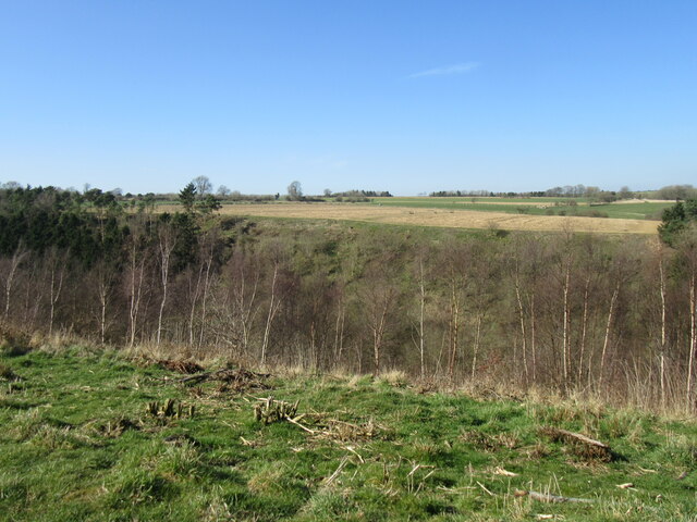
Flassen Dale is a picturesque valley located in the county of Yorkshire, England. Nestled amidst rolling hills and lush green landscapes, it is a place of natural beauty and tranquility. The valley stretches for approximately four miles, offering visitors stunning views and a sense of serenity.

The main feature of Flassen Dale is the meandering river that runs through it. The river, known as the Flassen River, is a tributary of the larger River Ouse and is a vital water source for the local wildlife. Its crystal-clear waters add to the charm of the valley, making it a popular spot for fishing and leisurely walks along its banks.

The valley is home to a diverse range of flora and fauna, with various species of trees, wildflowers, and wildlife inhabiting the area. It is a sanctuary for many bird species, including the kingfisher, herons, and various waterfowl, making it a haven for birdwatchers and nature enthusiasts.

Flassen Dale is also rich in history, with evidence of human habitation dating back centuries. The area boasts several ancient landmarks, such as burial mounds and stone circles, indicating its significance in the past. Visitors can explore these historical sites and learn about the valley's past through guided tours or self-guided walks.

With its idyllic setting and natural wonders, Flassen Dale is a haven for outdoor enthusiasts, offering activities such as hiking, cycling, and picnicking. Its unspoiled beauty and tranquil atmosphere make it a perfect retreat for those seeking a peaceful escape from the hustle and bustle of modern life.

If you have any feedback on the listing, please let us know in the comments section below.

Flassen Dale Images

Images are sourced within 2km of 54.249148/-1.1699922 or Grid Reference SE5484. Thanks to Geograph Open Source API. All images are credited.

Town's Pasture This field is named on the OS map as 'Town's Pasture'.
Town's Pasture
This field is named on the OS map as 'Town's Pasture'.
View from Cold Kirby Road Looking east from Cold Kirby Road.
View from Cold Kirby Road
Looking east from Cold Kirby Road.
Training gallops at Hambleton House Racehorse training must have been an activity here for many years as somewhere near here was one of the first three official racecourses in England dating back to 1740. There's no evidence of a laid out course on first edition OS maps, so races could have been across open ground. Racing eventually moved to the less draughty location of Thirsk in the 19th century.
Training gallops at Hambleton House
Racehorse training must have been an activity here for many years as somewhere near here was one of the first three official racecourses in England dating back to 1740. There's no evidence of a laid out course on first edition OS maps, so races could have been across open ground. Racing eventually moved to the less draughty location of Thirsk in the 19th century.
Above Flassen Dale Looking NW from the path that is not waymarked and very overgrown and hard to find in places.
Above Flassen Dale
Looking NW from the path that is not waymarked and very overgrown and hard to find in places.
Shooting hut in Flassen Dale There were other huts nearby.
Shooting hut in Flassen Dale
There were other huts nearby.
Back Lane Long straight country lane heading for Old Byland
Back Lane
Long straight country lane heading for Old Byland
Countryside beside Back Lane
Bridleway on Town's Pasture Bridleway heading north from Back Lane to High Leir Lane
Bridleway on Town's Pasture
Bridleway heading north from Back Lane to High Leir Lane
Early Morning in Country West of Old Byland
Entering Old Byland The country lane from Cold Kirby entering the village of Old Byland
Entering Old Byland
The country lane from Cold Kirby entering the village of Old Byland
Cairn beside the Lane between Cold Kirby and Old Byland A mound at the edge of this pasture, marked on the map as a cairn in writing that indicates a Non Roman Antiquity - what used to be called a tumulus.
Research suggests this is a round barrow.
Cairn beside the Lane between Cold Kirby and Old Byland
A mound at the edge of this pasture, marked on the map as a cairn in writing that indicates a Non Roman Antiquity - what used to be called a tumulus. Research suggests this is a round barrow.
Town's Pasture Looking NE across Town's Pasture.
Town's Pasture
Looking NE across Town's Pasture.
Cold Kirby, road from the west According to the OS benchmark database there is a benchmark at this location cut into a gatepost on the north side of the lane. Both gateposts are new.
Cold Kirby, road from the west
According to the OS benchmark database there is a benchmark at this location cut into a gatepost on the north side of the lane. Both gateposts are new.
Cold Kirby, road from the west According to the OS benchmark database there is a benchmark cut into the roadside wall on the north side of the road.
Cold Kirby, road from the west
According to the OS benchmark database there is a benchmark cut into the roadside wall on the north side of the road.
Cold Kirby, Chapel Cottage According to the OS benchmark database there is a benchmark cut into the east facing wall. The high hedges prevented any view.
Cold Kirby, Chapel Cottage
According to the OS benchmark database there is a benchmark cut into the east facing wall. The high hedges prevented any view.
Cold Kirby, Oakdale The benchmark is cut into the gable end of the converted farm building which is now a private house, Oakdale.
Cold Kirby, Oakdale
The benchmark is cut into the gable end of the converted farm building which is now a private house, Oakdale.
Cold Kirby, Oakdale There is a benchmark cut into the gable end of the converted farm building, which is now a private house, Oakdale.
Cold Kirby, Oakdale
There is a benchmark cut into the gable end of the converted farm building, which is now a private house, Oakdale.
Cold Kirby, St Michael's church The worn and weathered benchmark is cut into the west face of the church tower.
Cold Kirby, St Michael's church
The worn and weathered benchmark is cut into the west face of the church tower.
Show me another place!

Flassen Dale is located at Grid Ref: SE5484 (Lat: 54.249148, Lng: -1.1699922)

Division: North Riding

Administrative County: North Yorkshire

District: Ryedale

Police Authority: North Yorkshire

What 3 Words

///line.speaker.wiggling. Near Helmsley, North Yorkshire

Nearby Locations

Flassen Dale Blind Side

Related Wikis

Cold Kirby

Cold Kirby is a village and civil parish in the Ryedale district of North Yorkshire, England. The population at the 2011 census (including Angram Grange...

Scawton

Scawton is a village and former civil parish in North Yorkshire, England. The hamlet lies just east of Sutton Bank, north of the A170 road, and 5 miles...

Old Byland and Scawton

Old Byland and Scawton is a civil parish in the Ryedale district, in the county of North Yorkshire, England. The parish includes the villages of Old Byland...

Hambleton, Ryedale

Hambleton is a hamlet on the A170 road between Thirsk and Pickering in North Yorkshire, England. It lies on the Hambleton Hills 1 mile east of Sutton Bank...

Battle of Old Byland

The Battle of Old Byland (also known as the Battle of Byland Abbey, the Battle of Byland Moor and the Battle of Scotch Corner) was a significant encounter...

Hambleton Hills

The Hambleton Hills are a range of hills in North Yorkshire, England. They form the western edge of the North York Moors but are separated from the moors...

Yorkshire Gliding Club

The Yorkshire Gliding Club (YGC) operate from an airfield on Sutton Bank in the North York Moors National Park, England. The airfield site is 7 miles...

Rievaulx

Rievaulx (usually pronounced REE-voh) is a small village and civil parish in Rye Dale within the North York Moors National Park near Helmsley in North...

Nearby Amenities

Located within 500m of 54.249148,-1.1699922
Barrier: stile
Lat/Long: 54.2465728/-1.1729725
Barrier: stile
Lat/Long: 54.2459815/-1.1721426
Barrier: stile
Lat/Long: 54.2459164/-1.1720201
The Pheasantry
Place: farm
Lat/Long: 54.2479682/-1.1686922
The data included in this document is from www.openstreetmap.org. The data is made available under ODbL.

Have you been to Flassen Dale?

Leave your review of Flassen Dale below (or comments, questions and feedback).