Ley Hill

Settlement in Warwickshire

England

Ley Hill

Rainbow over Heath Croft Road A rainbow after a short, sharp, summer shower.
Rainbow over Heath Croft Road Credit: David P Howard

Ley Hill is a small village located in Warwickshire, England. It is situated near the town of Warwick and the city of Coventry. The village is known for its picturesque countryside, with rolling hills and lush green fields surrounding the area.

Ley Hill is a quiet and peaceful village, with a close-knit community of residents. The village has a few amenities, including a local pub, post office, and primary school. The village is also home to a historic church, which dates back to the 12th century and is a popular attraction for visitors.

The village is surrounded by beautiful walking and cycling trails, making it a popular destination for outdoor enthusiasts. The nearby countryside offers stunning views and plenty of opportunities to explore nature.

Overall, Ley Hill is a charming and idyllic village in Warwickshire, offering a peaceful retreat from the hustle and bustle of city life. Its natural beauty and close community make it a desirable place to live or visit.

If you have any feedback on the listing, please let us know in the comments section below.
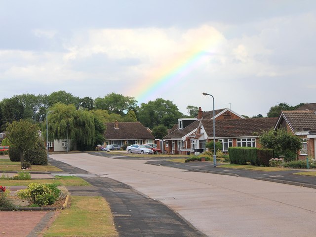
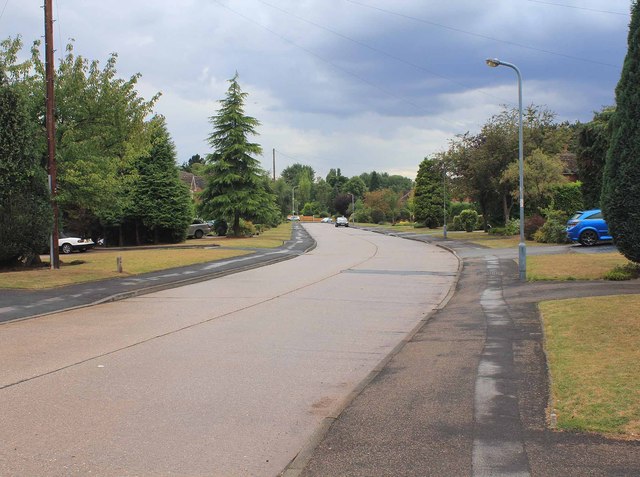
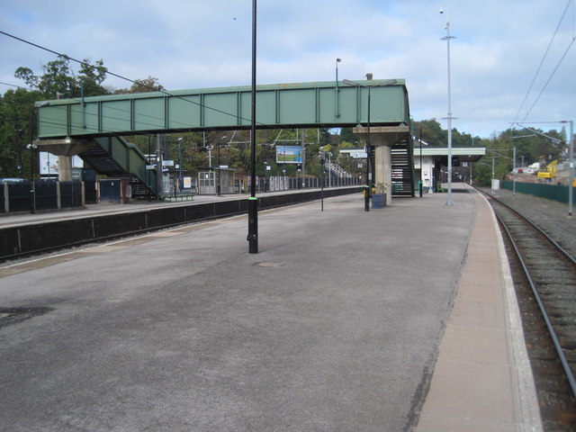
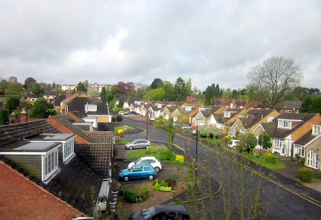
Ley Hill Images

Images are sourced within 2km of 52.585423/-1.833921 or Grid Reference SP1198. Thanks to Geograph Open Source API. All images are credited.

Rainbow over Heath Croft Road A rainbow after a short, sharp, summer shower.
Rainbow over Heath Croft Road
A rainbow after a short, sharp, summer shower.
Heath Croft Road Looking SW down Heath Croft Road.
Heath Croft Road
Looking SW down Heath Croft Road.
Dunton Close off Hillwood Common Road
Amington Close off Worcester Lane, Roughley
Worcester Close off Worcester Lane, Sutton Coldfield
Four Oaks railway station Opened in 1884 by the London & North Western Railway on the line from Birmingham New Street to Lichfield. View north towards Butlers Lane and Lichfield.
Four Oaks railway station
Opened in 1884 by the London & North Western Railway on the line from Birmingham New Street to Lichfield. View north towards Butlers Lane and Lichfield.
Butlers Lane railway station Opened in 1957 by British Rail on the line from Birmingham New Street to Lichfield. View north west towards Blake Street and Lichfield.
Butlers Lane railway station
Opened in 1957 by British Rail on the line from Birmingham New Street to Lichfield. View north west towards Blake Street and Lichfield.
Butlers Lane railway station Opened in 1957 by British Rail on the line from Birmingham New Street to Lichfield. View south east towards Four Oaks and Birmingham.
Butlers Lane railway station
Opened in 1957 by British Rail on the line from Birmingham New Street to Lichfield. View south east towards Four Oaks and Birmingham.
Haig Close Four Oaks Sutton Coldfield
Four Oaks Railway Station, Sutton Coldfield
Church, Four Oaks From Railway Station
Sutton Park railway station (site), Birmingham Opened in 1879 by the Midland Railway on the line from Castle Bromwich to Walsall, this station closed to passengers in 1965.
View north west towards Streetley and Walsall.
Sutton Park railway station (site), Birmingham
Opened in 1879 by the Midland Railway on the line from Castle Bromwich to Walsall, this station closed to passengers in 1965. View north west towards Streetley and Walsall.
Allesley Close Sutton Coldfield
Sutton Coldfield, A453 Tamworth Road
Four Oaks Station Drive
Cross City Line at Four Oaks Station Looking Southwards
The Old Speckled Hen, Mere Green
Mere Green Road, Mere Green
Show me another place!

Ley Hill is located at Grid Ref: SP1198 (Lat: 52.585423, Lng: -1.833921)

Unitary Authority: Birmingham

Police Authority: West Midlands

What 3 Words

///trip.extra.shop. Near Sutton Coldfield, West Midlands

Nearby Locations

Ley Hill

Related Wikis

Four Oaks, Sutton Coldfield

Four Oaks is an affluent residential area in Sutton Coldfield, West Midlands, lying along the north and east borders of Sutton Park. Four Oaks is situated...

Mere Green, Birmingham

Mere Green is a small commercial centre in Four Oaks, Sutton Coldfield , England. == Facilities == Mere Green includes a mixture of independent shops,...

A5127 road

The A5127 is a major road in England which runs between Birmingham and Lichfield, Staffordshire. For much of the route the road follows the old route of...

The Arthur Terry School

The Arthur Terry School is a secondary school and sixth form with academy status in the Four Oaks area of Sutton Coldfield, England. It is Ofsted Good...

Nearby Amenities

Located within 500m of 52.585423,-1.833921
Crossing
Crossing: uncontrolled
Crossing Ref: zebra
Lat/Long: 52.5879128/-1.830385
Crossing
Crossing: uncontrolled
Crossing Ref: zebra
Tactile Paving: yes
Lat/Long: 52.5876046/-1.8305781
Turning Circle
Source: bing
Lat/Long: 52.5872694/-1.8350534
Turning Circle
Source: bing
Lat/Long: 52.5893591/-1.8374691
Post Box
Postal Code: B75
Ref: B75 334
Lat/Long: 52.5845652/-1.8284151
Post Box
Postal Code: B74
Ref: B74 847
Lat/Long: 52.5828052/-1.8340301
Barrier: cattle_grid
Lat/Long: 52.5847825/-1.8400028
Bus Stop
Lichfield Rd / Mere Green
Asset Ref: 0573701
Bus: yes
Location: Lichfield Road;Mere Green
Naptan AtcoCode: 43000573701
Naptan Bearing: S
Naptan BusStopType: MKD
Naptan CommonName: Mere Green
Naptan Indicator: before
Naptan NaptanCode: nwmgtmtj
Naptan PlusbusZoneRef: BHAMNWS
Naptan Status: ACT
Naptan StopType: BCT
Naptan Street: LICHFIELD RD
Naptan Towards: Sutton Coldfield
Public Transport: platform
Route Ref: School services only
Shelter: no
Source: WMCA
Lat/Long: 52.5881676/-1.8304957
Bus Stop
Lichfield Rd / Mere Green
Asset Ref: 0573702
Bus: yes
Location: Lichfield Road;Mere Green
Naptan AtcoCode: 43000573702
Naptan Bearing: N
Naptan BusStopType: MKD
Naptan CommonName: Mere Green
Naptan Indicator: after
Naptan NaptanCode: nwmgtmtm
Naptan PlusbusZoneRef: BHAMNWS
Naptan Status: ACT
Naptan StopType: BCT
Naptan Street: LICHFIELD RD
Naptan Towards: Lichfield
Public Transport: platform
Route Ref: School services only
Shelter: no
Source: WMCA
Lat/Long: 52.588273/-1.8307676
Bus Stop
Belwell Lane / Waitrose
Bench: no
Bin: no
Bus: yes
Lit: yes
Naptan AtcoCode: 43000573902
Naptan Bearing: NE
Naptan BusStopType: MKD
Naptan CommonName: Waitrose
Naptan Indicator: adj
Naptan NaptanCode: nwmgtmtw
Naptan PlusbusZoneRef: BHAMNWS
Naptan Status: ACT
Naptan StopType: BCT
Naptan Street: BELWELL LANE
Naptan Towards: Sutton Coldfield
Naptan Verified: no
Public Transport: platform
Route Ref: 6;78;X12;X3
Shelter: no
Source: WMCA
Tactile Paving: no
Lat/Long: 52.5875186/-1.8312724
Clarence Rd / Arthur Terry School
Naptan AtcoCode: 43000574001
Naptan Bearing: NW
Naptan BusStopType: CUS
Naptan CommonName: Arthur Terry School
Naptan Indicator: opp
Naptan NaptanCode: nwmgtmwa
Naptan PlusbusZoneRef: BHAMNWS
Naptan Status: ACT
Naptan StopType: BCT
Naptan Street: CLARENCE RD
Naptan Towards: Hill Hook
Naptan Verified: no
Route Ref: X12;X3
Source: WMCA
Lat/Long: 52.5876175/-1.8377076
Clarence Rd / Arthur Terry School
Naptan AtcoCode: 43000574002
Naptan Bearing: SE
Naptan BusStopType: CUS
Naptan CommonName: Arthur Terry School
Naptan Indicator: adj
Naptan NaptanCode: nwmgtmwd
Naptan PlusbusZoneRef: BHAMNWS
Naptan Status: ACT
Naptan StopType: BCT
Naptan Street: CLARENCE RD
Naptan Towards: Sutton Coldfield
Naptan Verified: no
Route Ref: X12;X3
Source: WMCA
Lat/Long: 52.5877419/-1.8375579
Bus Stop
Lichfield Rd / Cremorne Rd
Asset Ref: 0574101
Bus: yes
Location: Lichfield Road;Cremorne Road
Naptan AtcoCode: 43000574101
Naptan Bearing: N
Naptan BusStopType: MKD
Naptan CommonName: Cremorne Rd
Naptan Indicator: opp
Naptan NaptanCode: nwmdjadm
Naptan PlusbusZoneRef: BHAMNWS
Naptan Status: ACT
Naptan StopType: BCT
Naptan Street: LICHFIELD RD
Naptan Towards: Mere Green
Public Transport: platform
Route Ref: 6;78;X12;X3;X5
Shelter: no
Source: WMCA
Towards: Mere Green
Lat/Long: 52.5834627/-1.8286189
Bus Stop
Lichfield Rd / Cremorne Rd
NaPTANAreaCode: 43000574102
Asset Ref: 503718
Bus: yes
Location: Lichfield Road;Cremorne Road
Naptan AtcoCode: 43000574102
Naptan Bearing: S
Naptan BusStopType: MKD
Naptan CommonName: Cremorne Rd
Naptan Indicator: adj
Naptan NaptanCode: nwmdjadp
Naptan PlusbusZoneRef: BHAMNWS
Naptan Status: ACT
Naptan StopType: BCT
Naptan Street: LICHFIELD RD
Naptan Towards: Sutton Coldfield
Public Transport: platform
Route Ref: 6;78;X12;X3;X5
Shelter: yes
Shelter Ref: 503718
Source: WMCA
Towards: Sutton Coldfield
Lat/Long: 52.5840182/-1.8286384
Bus Stop
Lichfield Rd / Barleys
NaPTANAreaCode: 43000574201
Asset Ref: 503702
Bus: yes
Location: Lichfield Road;Barleys
Naptan AtcoCode: 43000574201
Naptan Bearing: N
Naptan BusStopType: MKD
Naptan CommonName: Barleys
Naptan Indicator: adj
Naptan NaptanCode: nwmdjadt
Naptan PlusbusZoneRef: BHAMNWS
Naptan Status: ACT
Naptan StopType: BCT
Naptan Street: LICHFIELD RD
Naptan Towards: Hill Hook, Roughley, Streetly
Naptan Verified: yes
Public Transport: platform
Route Ref: 6;78;X12;X3;X5
Shelter: yes
Shelter Ref: 503702
Source: WMCA
Towards: Hillhook;Roughley;Streetly
Lat/Long: 52.5873328/-1.8302093
Bus Stop
Lichfield Rd / Barleys
NaPTANAreaCode: 43000574202
Bench: yes
Bin: no
Bus: yes
Lit: yes
Naptan AtcoCode: 43000574202
Naptan Bearing: S
Naptan BusStopType: MKD
Naptan CommonName: Barleys
Naptan Indicator: opp
Naptan NaptanCode: nwmdjadw
Naptan PlusbusZoneRef: BHAMNWS
Naptan Status: ACT
Naptan StopType: BCT
Naptan Street: LICHFIELD RD
Naptan Towards: Sutton Coldfield
Public Transport: platform
Route Ref: 6;78;X12;X3;X5
Shelter: yes
Shelter Ref: 503716
Source: WMCA
Tactile Paving: no
Lat/Long: 52.5869484/-1.8298756
Bus Stop
Belwell Lane / Clarence Rd
Bus: yes
Naptan AtcoCode: 43000574701
Naptan Bearing: E
Naptan BusStopType: MKD
Naptan CommonName: Clarence Rd
Naptan Indicator: adj
Naptan NaptanCode: nwmgtpam
Naptan PlusbusZoneRef: BHAMNWS
Naptan Status: ACT
Naptan StopType: BCT
Naptan Street: BELWELL LANE
Naptan Towards: Sutton Coldfield
Naptan Verified: yes
Public Transport: platform
Route Ref: 6;78
Shelter: no
Source: WMCA
Lat/Long: 52.5864182/-1.8365612
Bus Stop
Belwell Lane / Clarence Rd
Bus: yes
Naptan AtcoCode: 43000574702
Naptan Bearing: W
Naptan BusStopType: MKD
Naptan CommonName: Clarence Rd
Naptan Indicator: opp
Naptan NaptanCode: nwmgtpap
Naptan PlusbusZoneRef: BHAMNWS
Naptan Status: ACT
Naptan StopType: BCT
Naptan Street: BELWELL LANE
Naptan Towards: Hill Hook, Streetly
Naptan Verified: yes
Public Transport: platform
Route Ref: 6;78;X12;X3
Shelter: no
Source: WMCA
Lat/Long: 52.5864625/-1.8350248
Mere Green Rd / Sainsburys
Naptan AtcoCode: 43000574801
Naptan Bearing: E
Naptan BusStopType: CUS
Naptan CommonName: Sainsburys
Naptan Indicator: opp
Naptan NaptanCode: nwmgtpat
Naptan PlusbusZoneRef: BHAMNWS
Naptan Status: ACT
Naptan StopType: BCT
Naptan Street: MERE GREEN RD
Naptan Towards: Whitehouse Common
Naptan Verified: no
Source: WMCA
Lat/Long: 52.5875852/-1.8275672
Bus Stop
Mere Green Rd / Sainsburys
Bus: yes
Naptan AtcoCode: 43000574802
Naptan Bearing: W
Naptan BusStopType: MKD
Naptan CommonName: Sainsburys
Naptan Indicator: adj
Naptan NaptanCode: nwmgtpaw
Naptan PlusbusZoneRef: BHAMNWS
Naptan Status: ACT
Naptan StopType: BCT
Naptan Street: MERE GREEN RD
Naptan Towards: Sutton Coldfield
Naptan Verified: no
Public Transport: platform
Route Ref: 604
Source: WMCA
Lat/Long: 52.5874951/-1.8274495
Post Box
Postal Code: B74
Ref: B74 1801
Source: GPS Survey
Lat/Long: 52.5882622/-1.8304285
Post Box
Postal Code: B74
Ref: B74 180
Source: GPS Survey
Lat/Long: 52.5882562/-1.8304559
Bicycle Parking
Bcc Ref: 360
Bicycle Parking: stands
Capacity: 12
Covered: no
Shelter: no
Lat/Long: 52.5866368/-1.8273357
Recycling
Lat/Long: 52.5868781/-1.8283807
Crossing
Crossing: uncontrolled
Lat/Long: 52.5871979/-1.8299062
Crossing
Crossing: uncontrolled
Lat/Long: 52.5871915/-1.8300334
Give Way
Lat/Long: 52.587343/-1.8300674
Crossing
Crossing: traffic_signals
Crossing Ref: pelican
Source Type: BCC_CycleData
Lat/Long: 52.587514/-1.8289002
Give Way
Lat/Long: 52.5876723/-1.8299274
Traffic Signals
Lat/Long: 52.586097/-1.840712
Grit Bin
Lat/Long: 52.5824067/-1.8305482
Give Way
Source: bing
Lat/Long: 52.5841163/-1.8371832
Better Gym Mere Green
Contact Website: https://www.better.org.uk/leisure-centre/birmingham/better-gym-mere-green
Entrance: yes
Leisure: fitness_centre
Old Name: Fitness First
Operator: Better
Sport: fitness
Lat/Long: 52.586515/-1.8287827
War Memorial
Heritage: 2
Heritage Operator: Historic England
Historic: memorial
Listed Status: Grade II
Memorial: obelisk
Source: bing;Historic England
Lat/Long: 52.5861369/-1.8405359
Crossing
Crossing: uncontrolled
Crossing Ref: zebra
Lat/Long: 52.5879335/-1.8298309
Give Way
Lat/Long: 52.5874699/-1.8298147
Give Way
Lat/Long: 52.5876785/-1.8303337
Give Way
Lat/Long: 52.5877812/-1.8302063
Pharmacy
Lloyds Pharmacy
Addr City: Sutton Coldfield
Addr Housenumber: 228
Addr Postcode: B74 2UE
Addr Street: Lichfield Road
Brand: Lloyds Pharmacy
Brand Wikidata: Q6662870
Brand Wikipedia: en:LloydsPharmacy
Fhrs Id: 604666
Fhrs Local Authority Id: PI/000512434
Healthcare: pharmacy
Source Addr: FHRS Open Data
Lat/Long: 52.5832162/-1.8281251
Bicycle Parking
Capacity: 16
Lat/Long: 52.5866682/-1.8287757
Bicycle Parking
Capacity: 32
Lat/Long: 52.5871139/-1.8297883
Grit Bin
Lat/Long: 52.5877926/-1.838036
Bicycle Parking
Bicycle Parking: stands
Capacity: 6
Covered: no
Mapillary: 305957487573918
Survey Date: 2018-07-24
Lat/Long: 52.587685/-1.8304581
Telephone
Booth: KX100
Covered: booth
Operator: British Telecom
Lat/Long: 52.5878708/-1.8304729
Atm
Lat/Long: 52.5879484/-1.8301549
Atm
Lat/Long: 52.5878137/-1.8305213
Atm
Lat/Long: 52.5877024/-1.8306163
Addr City: Sutton Coldfield
Addr Housename: Mere Green Chambers
Addr Housenumber: 338
Addr Street: Lichfield Road
Lat/Long: 52.5881978/-1.830354
Post Box
Ref: B74 842
Lat/Long: 52.5859529/-1.8403335
Entrance: main
Lat/Long: 52.5862787/-1.8404957
Defibrillator
Emergency: defibrillator
Indoor: no
Lat/Long: 52.5853472/-1.829268
The data included in this document is from www.openstreetmap.org. The data is made available under ODbL.

Have you been to Ley Hill?

Leave your review of Ley Hill below (or comments, questions and feedback).