Voes Bottom

Valley in Shetland

Scotland

Voes Bottom

Bus at a junction at Voe The Viking Energy windfarm in the background.
Bus at a junction at Voe Credit: Mike Pennington

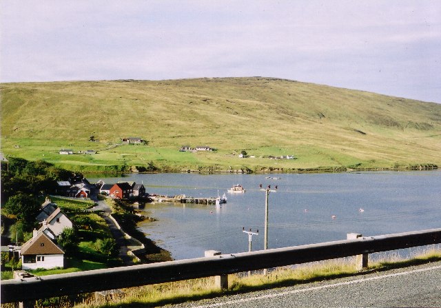
Voes Bottom is a picturesque valley located in the Shetland Islands, an archipelago in Scotland. Situated on the mainland of Shetland, this valley is known for its stunning natural beauty and rich history.

The valley is nestled between rolling hills, offering breathtaking views of the surrounding landscape. Lush green pastures, meandering streams, and scattered wildflowers create a serene and idyllic atmosphere. The valley is also home to a variety of wildlife, including birds, sheep, and ponies, making it a haven for nature enthusiasts and photographers.

Voes Bottom holds significant historical importance as well. It was once a thriving agricultural hub, with farms and crofts dotting the landscape. The remnants of these traditional dwellings can still be seen, offering a glimpse into the past way of life in the area.

The valley is also known for its rich archaeological heritage. Excavations have uncovered ancient artifacts, including tools and pottery, dating back thousands of years. These findings shed light on the early human settlements in the region and provide valuable insight into the history of the Shetland Islands.

Voes Bottom is a popular destination for hikers and walkers, with several trails and paths crisscrossing the valley. These routes allow visitors to explore the area at their own pace, immersing themselves in the tranquility of the surroundings.

Overall, Voes Bottom is a hidden gem within the Shetland Islands, offering a unique blend of natural beauty and historical significance. Whether you are seeking a peaceful retreat or a chance to delve into the past, this valley has something to offer for everyone.

If you have any feedback on the listing, please let us know in the comments section below.

Voes Bottom Images

Images are sourced within 2km of 60.350191/-1.2585041 or Grid Reference HU4163. Thanks to Geograph Open Source API. All images are credited.

Bus at a junction at Voe The Viking Energy windfarm in the background.
Bus at a junction at Voe
The Viking Energy windfarm in the background.
Constructing aerogenerators near Voe
"Honestas" in Voe Harbour For some reason I assumed this fine boat was permanently moored here, it looks so much part of the scenery.
But it doesn't feature in any other pictures of the harbour so I guess it's a visitor and I was lucky to get this shot.
"Honestas" in Voe Harbour
For some reason I assumed this fine boat was permanently moored here, it looks so much part of the scenery. But it doesn't feature in any other pictures of the harbour so I guess it's a visitor and I was lucky to get this shot.
Lower Voe The head of Olna Firth, which is frozen.
Lower Voe
The head of Olna Firth, which is frozen.
Frozen marina at Voe Olna Firth is salt water, but is enclosed and has frozen after several days of very hard frosts.
Frozen marina at Voe
Olna Firth is salt water, but is enclosed and has frozen after several days of very hard frosts.
Olna Firth at Voe This sheltered arm of the sea has frozen in the hard frosts of recent nights.
Olna Firth at Voe
This sheltered arm of the sea has frozen in the hard frosts of recent nights.
Roadside pund west of Sussetter Hill, Voe A pund is a gathering place for sheep.
Roadside pund west of Sussetter Hill, Voe
A pund is a gathering place for sheep.
The Manse Rocky stream at Voe
The Manse
Rocky stream at Voe
Houses at Voe A view of houses at Voe
Houses at Voe
A view of houses at Voe
Road at Hamars The A968 Road at Hamars
Road at Hamars
The A968 Road at Hamars
A968 road View to Olna Firth
A968 road
View to Olna Firth
Colourful Housing This is Mulla, nice bright colours against the green hillside.
Colourful Housing
This is Mulla, nice bright colours against the green hillside.
Valley of the Burn of Sursetter The Burn of Sursetter is around 3 kms long and flows into Olna Firth. The conical thing in the foreground is a stack of rusty metal fence posts.
Valley of the Burn of Sursetter
The Burn of Sursetter is around 3 kms long and flows into Olna Firth. The conical thing in the foreground is a stack of rusty metal fence posts.
Overlooking Voe Harbour
Information Board at Voe There is a lay by and overlook beside the road with a view over the harbour and a visitor board with history and old pictures of the development of Voe.
Information Board at Voe
There is a lay by and overlook beside the road with a view over the harbour and a visitor board with history and old pictures of the development of Voe.
The daggerfly Empis tessellata, Loch of Voe A common predacious fly.
The daggerfly Empis tessellata, Loch of Voe
A common predacious fly.
The hoverfly Sericomyia silentis, Loch of Voe Necataring on Marsh Thistle (Cirsium palustre).
The hoverfly Sericomyia silentis, Loch of Voe
Necataring on Marsh Thistle (Cirsium palustre).
Loch of Voe From within the plantation.
Loch of Voe
From within the plantation.
Show me another place!

Voes Bottom is located at Grid Ref: HU4163 (Lat: 60.350191, Lng: -1.2585041)

Unitary Authority: Shetland Islands

Police Authority: Highlands and Islands

What 3 Words

///elbow.demoted.momentous. Near Vidlin, Shetland Islands

Nearby Locations

Voes Bottom

Related Wikis

Voe, Delting

Voe is a village in Delting parish on Mainland, Shetland, Scotland. It is one of the three main settlements in Delting. It is at the junction of the A968...

Laxo

Laxo is a small settlement at the end of Laxo Voe in Vidlin, Shetland, Scotland. A ferry from the Mainland to Symbister in Whalsay operates from the nearby...

Shetland

Shetland, also called the Shetland Islands, is an archipelago in Scotland lying between Orkney, the Faroe Islands, and Norway. It is the northernmost region...

Viking Wind Farm

Viking Wind Farm is a large on-shore wind farm under construction in the Shetland Islands which is being developed by Viking Energy, a partnership between...

Nearby Amenities

Located within 500m of 60.350191,-1.2585041
Pierhead
Addr City: Shetland
Addr Postcode: ZE2 9PX
Disused Amenity: pub
Source Addr Postcode: FHRS Open Data
Wheelchair: yes
Lat/Long: 60.3501241/-1.2665443
The Sail Loft
Tourism: hostel
Lat/Long: 60.350493/-1.265922
Toilets
Wheelchair: limited
Lat/Long: 60.3504604/-1.2548446
Millennium Milepost
Artist Name: Andrew Rowe
Bicycle: yes
Cycle Network: UK:National Cycle Network
Description: Sustrans Millennium Milepost for National Cycle Network route 1, indicating west to Bixter (11 miles) and Lerwick (28 miles), north (via ferry) to ? and east to ?.
Destination: Bixter;Lerwick
Direction: 130
Fixme: north and east destinations need checking
Guide Type: destination
Information: guidepost
Material: metal
Ncn Milepost: rowe
Note: Sustrans cancelled the NCN1 route here in Summer 2020
Operator: Sustrans
Sustrans Ref: MP1094
Tourism: information
Website: https://www.sustrans.org.uk/national-cycle-network/millennium-mileposts
Lat/Long: 60.350154/-1.26713
Power: pole
Lat/Long: 60.3489251/-1.2553046
Power: pole
Lat/Long: 60.3495329/-1.2553622
Power: pole
Lat/Long: 60.3495846/-1.2555151
Power: pole
Lat/Long: 60.3496337/-1.2556412
Power: pole
Lat/Long: 60.3459965/-1.2552254
Power: pole
Lat/Long: 60.3467622/-1.2552147
Power: pole
Lat/Long: 60.3479794/-1.2552934
Post Box
Operator: Royal Mail
Ref: ZE2 66
Lat/Long: 60.3501406/-1.2667268
Barrier: cattle_grid
Lat/Long: 60.3542903/-1.2611843
Historic: memorial
Lat/Long: 60.3516912/-1.258825
Barrier: cattle_grid
Lat/Long: 60.3506748/-1.2547886
Barrier: cattle_grid
Lat/Long: 60.3515638/-1.2544801
Natural: beach
Surface: paving_stones
Lat/Long: 60.3513192/-1.2620253
Recycling
Recycling Cans: yes
Recycling Glass: yes
Recycling Type: container
Lat/Long: 60.3503348/-1.2665166
Olnafirth Sea Farms ltd
Office: company
Lat/Long: 60.3504547/-1.2661094
Barrier: stile
Motor Vehicle: no
Lat/Long: 60.3507556/-1.2638956
Bench: yes
Leisure: picnic_table
Lit: no
Lat/Long: 60.3512564/-1.2618313
Leisure: slipway
Lat/Long: 60.3506997/-1.2660047
Bus Stop
Lower Voe Junction
Bus: yes
Public Transport: platform
Shelter: yes
Lat/Long: 60.3480313/-1.2534297
Leisure: slipway
Lat/Long: 60.3508034/-1.2665307
Power: pole
Lat/Long: 60.3467888/-1.2546864
Power: pole
Lat/Long: 60.3475903/-1.2546623
Power: pole
Lat/Long: 60.3480866/-1.2546381
Power: pole
Lat/Long: 60.3486226/-1.254606
Power: pole
Lat/Long: 60.3492596/-1.2545604
Power: pole
Lat/Long: 60.3496517/-1.2553436
Power: pole
Lat/Long: 60.3534789/-1.2645113
Power: pole
Lat/Long: 60.3530915/-1.2636289
Power: pole
Lat/Long: 60.3527107/-1.2627411
Power: pole
Lat/Long: 60.3522795/-1.2617487
Power: pole
Lat/Long: 60.3518456/-1.2607455
Power: pole
Lat/Long: 60.3515988/-1.260193
Power: pole
Lat/Long: 60.3511437/-1.2591738
Power: pole
Lat/Long: 60.3507377/-1.2582618
Power: pole
Lat/Long: 60.3503224/-1.2573378
Power: pole
Lat/Long: 60.3498202/-1.2561978
Power: pole
Lat/Long: 60.3497638/-1.255829
Power: pole
Lat/Long: 60.3498567/-1.2560007
Power: pole
Lat/Long: 60.3503927/-1.2570736
Power: pole
Lat/Long: 60.3510018/-1.2584683
Power: pole
Lat/Long: 60.3516121/-1.2599033
Power: pole
Lat/Long: 60.3522649/-1.2613678
Power: pole
Lat/Long: 60.3528938/-1.2627974
Power: pole
Lat/Long: 60.3535638/-1.2643611
Give Way
Direction: forward
Lat/Long: 60.3501609/-1.2669776
Artwork Type: sculpture
Description: fish on a small cairn
Material: stone
Tourism: artwork
Lat/Long: 60.3501833/-1.2671276
Power: pole
Lat/Long: 60.3494897/-1.253518
Power: pole
Lat/Long: 60.3495854/-1.2519487
Power: pole
Lat/Long: 60.3496653/-1.2504626
Power: pole
Lat/Long: 60.3493565/-1.2564045
Power: pole
Lat/Long: 60.3493456/-1.2565416
Power: pole
Lat/Long: 60.3493347/-1.2567643
Power: pole
Lat/Long: 60.3492233/-1.2577069
Power: pole
Lat/Long: 60.3491845/-1.2588404
Power: pole
Lat/Long: 60.3491361/-1.2600082
Power: pole
Lat/Long: 60.3490961/-1.2612029
Power: pole
Lat/Long: 60.3490392/-1.2626547
Power: pole
Lat/Long: 60.3489786/-1.26406
Power: pole
Lat/Long: 60.3489423/-1.2651152
Power: pole
Lat/Long: 60.3489399/-1.265431
Power: pole
Lat/Long: 60.3489302/-1.2662732
Power: pole
Lat/Long: 60.3491772/-1.2666037
Power: pole
Lat/Long: 60.3495273/-1.2654114
Power: pole
Lat/Long: 60.3496496/-1.2651837
Power: pole
Lat/Long: 60.3500711/-1.2652156
Power: pole
Lat/Long: 60.3516419/-1.2585613
Power: pole
Lat/Long: 60.3522098/-1.2586323
Power: pole
Lat/Long: 60.3525998/-1.2586911
Power: pole
Lat/Long: 60.3530854/-1.2587621
Power: pole
Lat/Long: 60.3535904/-1.2588257
Power: pole
Lat/Long: 60.3543037/-1.2586421
Power: pole
Lat/Long: 60.3535032/-1.2604685
Power: pole
Lat/Long: 60.3534342/-1.2618713
Power: pole
Lat/Long: 60.3525828/-1.2602726
Power: pole
Lat/Long: 60.352647/-1.2610022
Power: pole
Lat/Long: 60.3530794/-1.2618027
Power: pole
Lat/Long: 60.3542601/-1.2621333
Power: pole
Lat/Long: 60.3481915/-1.2661445
Power: pole
Lat/Long: 60.3486955/-1.2654532
Voe Freeview Transmitter
Man Made: antenna
Lat/Long: 60.3532699/-1.2602942
The data included in this document is from www.openstreetmap.org. The data is made available under ODbL.

Have you been to Voes Bottom?

Leave your review of Voes Bottom below (or comments, questions and feedback).