Webb's Gully

Valley in Wiltshire

England

Webb's Gully

Digger in the Bracken In a clearing in Castle Copse. Obviously abandoned here for some time, with broken windows and bracken growing up through the cab.
Digger in the Bracken Credit: Des Blenkinsopp

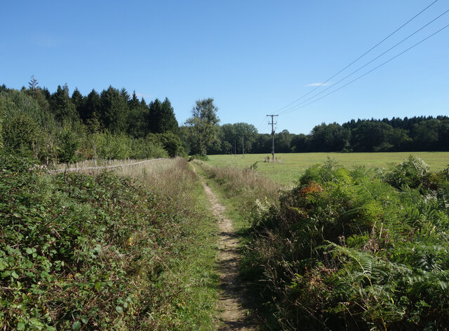
Webb's Gully is a picturesque valley located in the county of Wiltshire, England. Nestled amid the rolling hills and green meadows of the region, this idyllic gully offers a serene and tranquil escape for nature enthusiasts and hikers alike.

The gully is named after its discoverer, Mr. James Webb, who stumbled upon it in the early 19th century while exploring the surrounding countryside. Its unique topography is characterized by steep sides and a narrow, winding pathway that meanders through the valley floor. Lush vegetation, including a variety of trees, ferns, and wildflowers, adorns the slopes, creating a verdant and enchanting setting.

A small stream, fed by natural springs, flows through the valley, adding to its charm and providing a source of water for the local wildlife. The stream cascades over small moss-covered rocks, creating tiny waterfalls that add to the gully's natural beauty.

Webb's Gully is home to a diverse range of flora and fauna, making it a haven for wildlife enthusiasts. Birdwatchers can spot various species in the area, including woodpeckers, kingfishers, and owls. Squirrels, rabbits, and even the occasional deer can be spotted darting through the undergrowth.

The gully offers several hiking trails, allowing visitors to explore its natural wonders at their own pace. These trails wind through the valley, offering stunning vistas of the surrounding countryside and providing ample opportunities for photography and relaxation.

Overall, Webb's Gully is a hidden gem in Wiltshire, offering a peaceful retreat for those seeking to immerse themselves in the beauty of nature.

If you have any feedback on the listing, please let us know in the comments section below.
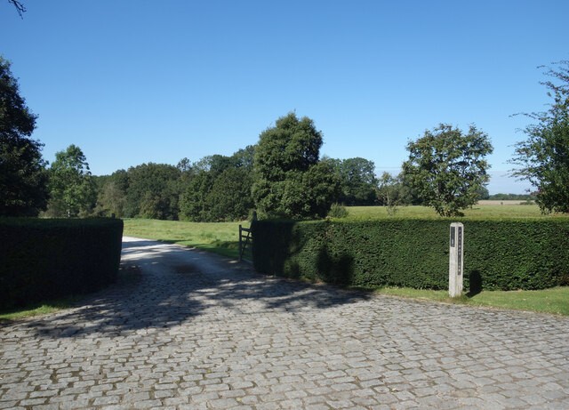
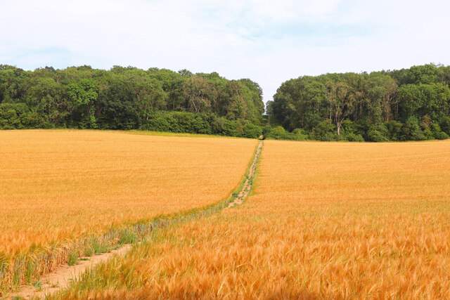
Webb's Gully Images

Images are sourced within 2km of 51.3697/-1.5751271 or Grid Reference SU2963. Thanks to Geograph Open Source API. All images are credited.

Digger in the Bracken In a clearing in Castle Copse. Obviously abandoned here for some time, with broken windows and bracken growing up through the cab.
Digger in the Bracken
In a clearing in Castle Copse. Obviously abandoned here for some time, with broken windows and bracken growing up through the cab.
Apples in the Plantation One of several new plantations I passed on my walk today where apple trees have been included in the mix along with oaks and wild cherries and other more usual woodland trees.
Apples in the Plantation
One of several new plantations I passed on my walk today where apple trees have been included in the mix along with oaks and wild cherries and other more usual woodland trees.
Lane to Newtown A short lane to the hamlet of Newtown which consists of a farm and around half a dozen houses.
Lane to Newtown
A short lane to the hamlet of Newtown which consists of a farm and around half a dozen houses.
Folly Farm Surrounded by fields and woods. This is a view from the bridleway which skirts around the edge of the farm outbuildings.
Folly Farm
Surrounded by fields and woods. This is a view from the bridleway which skirts around the edge of the farm outbuildings.
Road to Folly Farm Also a public bridleway.
Road to Folly Farm
Also a public bridleway.
Burridge Heath Farm A neat and tidy place along a quiet lane.
Burridge Heath Farm
A neat and tidy place along a quiet lane.
Entrance to Foxwood Farm Probably no longer in the agriculture business.
Entrance to Foxwood Farm
Probably no longer in the agriculture business.
Bridleway near Bedwyn Just one of the many paths around this pleasant area of fields and woods all within easy reach of Bedwyn Station.
Bridleway near Bedwyn
Just one of the many paths around this pleasant area of fields and woods all within easy reach of Bedwyn Station.
Frog Lane, Great Bedwyn Did people consciously build beautiful cottages back then, or was there just nothing around to build ugly ones with.
Frog Lane, Great Bedwyn
Did people consciously build beautiful cottages back then, or was there just nothing around to build ugly ones with.
Buntmill Lock Lock on the Kennet & Avon canal.
Buntmill Lock
Lock on the Kennet & Avon canal.
Towards Bedwyn Brail Footpath across the field.
Towards Bedwyn Brail
Footpath across the field.
Jockey Green Footpath near Bedwyn.
Jockey Green
Footpath near Bedwyn.
Near Folly Farm View down the lane towards Folly Farm.
Near Folly Farm
View down the lane towards Folly Farm.
Near Foxwood Farm From the footpath near Foxwood Farm.
Near Foxwood Farm
From the footpath near Foxwood Farm.
The junction of Burr Lane, Kingston Road and Rivar Road in Shalbourne Looking north-eastward.
The junction of Burr Lane, Kingston Road and Rivar Road in Shalbourne
Looking north-eastward.
Farmland, Shalbourne A view towards Rivar Hill and Rivar Farm from the A338 above the village.
Farmland, Shalbourne
A view towards Rivar Hill and Rivar Farm from the A338 above the village.
Old Milestone by the A338, Shalbourne Hungerford tombstone by the A338, in parish of Shalbourne (Kennet District), South of Newtown Store, 10m North of footpath sign, on nettle covered bank in front of hedge.

Inscription reads:-
HUNGERFORD
4
SARUM
23

Grade II listed.
List Entry Number: 1365516 <span class="nowrap"><a title="https://historicengland.org.uk/listing/the-list/list-entry/1365516" rel="nofollow ugc noopener" href="https://historicengland.org.uk/listing/the-list/list-entry/1365516">Link</a><img style="margin-left:2px;" alt="External link" title="External link - shift click to open in new window" src="https://s1.geograph.org.uk/img/external.png" width="10" height="10"/></span>

Surveyed

Milestone Society National ID: WI_hgsa04
Old Milestone by the A338, Shalbourne
Hungerford tombstone by the A338, in parish of Shalbourne (Kennet District), South of Newtown Store, 10m North of footpath sign, on nettle covered bank in front of hedge. Inscription reads:- HUNGERFORD 4 SARUM 23 Grade II listed. List Entry Number: 1365516 LinkExternal link Surveyed Milestone Society National ID: WI_hgsa04
The entrance to Tyler Hardwoods, Shalbourne
Show me another place!

Webb's Gully is located at Grid Ref: SU2963 (Lat: 51.3697, Lng: -1.5751271)

Unitary Authority: Wiltshire

Police Authority: Wiltshire

What 3 Words

///unionists.traffic.shepherds. Near Shalbourne, Wiltshire

Related Wikis

Shalbourne

Shalbourne is a village and civil parish in the English county of Wiltshire, about 3 miles (4.8 km) southwest of Hungerford, Berkshire. The parish has...

Bedwyn Church Lock

Bedwyn Church Lock is on the Kennet and Avon Canal at Great Bedwyn, Wiltshire, England. The lock has a rise/fall of 7 ft 11 in (2.41 m). It is a Grade...

Burnt Mill Lock

Burnt Mill Lock is on the Kennet and Avon Canal, at Great Bedwyn, Wiltshire, England. The lock has a rise/fall of 7 ft 9 in (2.36 m). == References... ==

Bedwyn railway station

Bedwyn railway station serves the village of Great Bedwyn in Wiltshire, England. It is 66 miles 33 chains (66.41 mi; 106.9 km) from the zero point at London...

Nearby Amenities

Located within 500m of 51.3697,-1.5751271
Post Box
Post Box Type: lamp
Ref: SN8 127
Royal Cypher: EIIR
Royal Cypher Wikidata: Q33102113
Lat/Long: 51.3659547/-1.572551
The data included in this document is from www.openstreetmap.org. The data is made available under ODbL.

Have you been to Webb's Gully?

Leave your review of Webb's Gully below (or comments, questions and feedback).