Tideswell Dale

Valley in Derbyshire Derbyshire Dales

England

Tideswell Dale

Red Telephone Box, Tideswell Situated between Fountain Street and Queen Street in the centre of Tideswell, this K6 telephone box is unusual that the words above the glass panes are "History" and "Tideswell" instead of "Telephone" as one can no longer make phone calls from this box, but listen to items of history covering Tideswell instead. The postcode of this telephone box is SK17 8JX.
Red Telephone Box, Tideswell Credit: David Hillas

Tideswell Dale, located in Derbyshire, England, is a picturesque valley renowned for its natural beauty and tranquil atmosphere. Nestled within the heart of the Peak District National Park, this idyllic valley stretches between the charming villages of Tideswell and Litton.

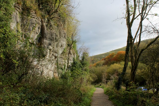
The dale is characterized by its lush green meadows, rolling hills, and meandering river, which adds to the visual splendor of the area. The landscape is dotted with ancient limestone formations, creating a unique geological setting that attracts nature enthusiasts and geologists alike.

Tideswell Dale is a haven for wildlife, providing a habitat for a diverse range of species. Visitors may spot various birds, including buzzards and peregrine falcons, soaring above the valley. The river is also home to a variety of fish, such as brown trout and grayling.

The valley offers numerous walking trails, allowing visitors to explore its natural wonders at their own pace. The paths wind through the valley, passing by charming stone bridges, old mill ruins, and vibrant wildflower meadows. In spring, the dale is awash with colorful blooms, creating a stunning display of nature's beauty.

For those seeking a peaceful retreat, Tideswell Dale offers a tranquil and serene ambiance. Its secluded location makes it an ideal spot for picnics, meditation, or simply enjoying the soothing sounds of nature.

Tideswell Dale is a hidden gem within the Peak District, offering visitors a chance to immerse themselves in the beauty of the British countryside. With its breathtaking scenery and abundant wildlife, this valley is a must-visit destination for nature lovers and those seeking an escape from the hustle and bustle of everyday life.

If you have any feedback on the listing, please let us know in the comments section below.

Tideswell Dale Images

Images are sourced within 2km of 53.262078/-1.7709826 or Grid Reference SK1573. Thanks to Geograph Open Source API. All images are credited.

Red Telephone Box, Tideswell Situated between Fountain Street and Queen Street in the centre of Tideswell, this K6 telephone box is unusual that the words above the glass panes are "History" and "Tideswell" instead of "Telephone" as one can no longer make phone calls from this box, but listen to items of history covering Tideswell instead. The postcode of this telephone box is SK17 8JX.
Red Telephone Box, Tideswell
Situated between Fountain Street and Queen Street in the centre of Tideswell, this K6 telephone box is unusual that the words above the glass panes are "History" and "Tideswell" instead of "Telephone" as one can no longer make phone calls from this box, but listen to items of history covering Tideswell instead. The postcode of this telephone box is SK17 8JX.
Tideswell Telephone Exchange Situated in Summer Cross, this TE is built from local limestone and would appear to date from the early 1970s. Besides Tideswell, this TE also serves Cressbrook, Great Hucklow, Grindlow, Little Hucklow, Litton, Miller's Dale, Tunstead, Wardlow, Wheston and Wormhill nearby. With the area this TE serves, it is perhaps not surprising that a large building is needed for its telephone and broadband services. Red doors and ventilation louvres can be seen in this photo. The numbering range of this TE is (01298) 87xxxx, the (01298) referring to the Buxton group of TEs, and its postcode is SK17 8HU.
Tideswell Telephone Exchange
Situated in Summer Cross, this TE is built from local limestone and would appear to date from the early 1970s. Besides Tideswell, this TE also serves Cressbrook, Great Hucklow, Grindlow, Little Hucklow, Litton, Miller's Dale, Tunstead, Wardlow, Wheston and Wormhill nearby. With the area this TE serves, it is perhaps not surprising that a large building is needed for its telephone and broadband services. Red doors and ventilation louvres can be seen in this photo. The numbering range of this TE is (01298) 87xxxx, the (01298) referring to the Buxton group of TEs, and its postcode is SK17 8HU.
A wet Sunday in Tideswell
The George Inn Tideswell
Litton, Bottomhill Road Gatepost BM BM on gatepost, E side of road
Litton, Bottomhill Road Gatepost BM
BM on gatepost, E side of road
Cressbrook, Bottomhill Road BM on roadside wall
Cressbrook, Bottomhill Road
BM on roadside wall
B6049 in Millers Dale In the deep wooded valley created by the River Wye, beside the turn off to Wormhill.
The Limestone Way long distance footpath also has been routed down here.
B6049 in Millers Dale
In the deep wooded valley created by the River Wye, beside the turn off to Wormhill. The Limestone Way long distance footpath also has been routed down here.
Twin Viaducts at Millers Dale These viaducts span the River Wye at Millers Dale. The first viaduct was built by the Midland Railway in 1866, with the second added in 1905 due to increased demand. Closed in 1968.
The southern viaduct now forms part of the Monsal Trail, an extremely popular leisure facility populated by walkers and cyclists.
Twin Viaducts at Millers Dale
These viaducts span the River Wye at Millers Dale. The first viaduct was built by the Midland Railway in 1866, with the second added in 1905 due to increased demand. Closed in 1968. The southern viaduct now forms part of the Monsal Trail, an extremely popular leisure facility populated by walkers and cyclists.
Autumn on the Monsal Trail Section of the former railway track that once connected Manchester to Matlock, opened in 1865.
Closed in 1968, the Monsal Trail has taken 8.5 miles of this link as a leisure facility for walkers, cyclists and the horse fraternity.
Autumn on the Monsal Trail
Section of the former railway track that once connected Manchester to Matlock, opened in 1865. Closed in 1968, the Monsal Trail has taken 8.5 miles of this link as a leisure facility for walkers, cyclists and the horse fraternity.
On the Monsal Trail Section of the former Manchester/Matlock railway that closed in 1968. Now a very popular 8.5 mile leisure trail.
On the Monsal Trail
Section of the former Manchester/Matlock railway that closed in 1968. Now a very popular 8.5 mile leisure trail.
Cutting on the Monsal Trail Section of the former Manchester to Matlock line, built by the Midland Railway in 1865.
It closed in 1968, with 8.5 miles converted to leisure use - populated by cyclists, walkers and the odd horse rider.
Cutting on the Monsal Trail
Section of the former Manchester to Matlock line, built by the Midland Railway in 1865. It closed in 1968, with 8.5 miles converted to leisure use - populated by cyclists, walkers and the odd horse rider.
Footbridge over the River Wye
The Road to Litton Mill Follows the course of the River Wye through Millers Dale
The Road to Litton Mill
Follows the course of the River Wye through Millers Dale
Footpath at Tongue End looking North West Beginning of the footpath that runs up Tideswell Dale
Footpath at Tongue End looking North West
Beginning of the footpath that runs up Tideswell Dale
The End of the Footpath that runs down Tideswell Dale The footpath reaches the road to Litton Mill, beside the River Wye.
The End of the Footpath that runs down Tideswell Dale
The footpath reaches the road to Litton Mill, beside the River Wye.
Path heading up Tideswell Dale (1)
Path heading up  Tideswell Dale (2) Gradual climb up this limestone dale towards the ancient village of Tideswell.
Path heading up Tideswell Dale (2)
Gradual climb up this limestone dale towards the ancient village of Tideswell.
Public Convenience in the Tideswell Dale Car Park
Show me another place!

Tideswell Dale is located at Grid Ref: SK1573 (Lat: 53.262078, Lng: -1.7709826)

Administrative County: Derbyshire

District: Derbyshire Dales

Police Authority: Derbyshire

What 3 Words

///slim.curtail.tram. Near Tideswell, Derbyshire

Related Wikis

Tideswell Dale

Tideswell Dale is a short dry limestone valley near Tideswell village, Derbyshire, in the Peak District of England. There is a farmland plateau on either...

Hubble (climb)

Hubble is a short 10-metre (33 ft) bolted sport climb at the limestone crag of Raven Tor in Miller's Dale, in the Peak District in Derbyshire, England...

Litton Mill

Litton Mill is a textile mill at Millers Dale, near Tideswell in Derbyshire. The original 19th-century mill became notorious during the Industrial Revolution...

Tideswell

Tideswell is a village, civil parish, and ward in the Peak District of Derbyshire, England. It lies 6 miles (9.7 km) east of Buxton on the B6049, in a...

Nearby Amenities

Located within 500m of 53.262078,-1.7709826
Barrier: stile
Lat/Long: 53.2647551/-1.7716127
Bench
Lat/Long: 53.2604823/-1.771554
Water Vole
Artwork Type: sculpture
Material: wood
Tourism: artwork
Lat/Long: 53.2607697/-1.7712544
Leisure: picnic_table
Lat/Long: 53.2641637/-1.7706428
Leisure: picnic_table
Lat/Long: 53.264195/-1.7706791
Tideswell (Dale Car Park)
Bus: yes
Public Transport: stop_position
Lat/Long: 53.2649976/-1.7715602
Tideswell Dale
Place: locality
Lat/Long: 53.2630696/-1.769228
Bus Stop
Tideswell (Dale Car Park)
Bus: yes
Naptan AtcoCode: 1000DTDC3233
Naptan NaptanCode: dbsdgwjt
Public Transport: platform
Lat/Long: 53.2649982/-1.7715
Bus Stop
Tideswell (Dale Car Park)
Bus: yes
Naptan AtcoCode: 1000DTDC3051
Naptan NaptanCode: dbsdgwjp
Public Transport: platform
Lat/Long: 53.2647908/-1.771557
Tideswell (Dale Car Park)
Bus: yes
Public Transport: stop_position
Lat/Long: 53.2648024/-1.7715164
Bus Stop
Miller’s Dale (Ravenstor Youth Hostel)
Bus: yes
Naptan AtcoCode: 1000DMDR3063
Naptan NaptanCode: dbsatgmd
Public Transport: platform
Lat/Long: 53.2586416/-1.7731731
Bus Stop
Miller’s Dale (Ravenstor Youth Hostel)
Bus: yes
Naptan AtcoCode: 1000DMDR3234
Naptan NaptanCode: dbsatgmg
Public Transport: platform
Lat/Long: 53.2586857/-1.7730095
Miller’s Dale (Ravenstor Youth Hostel)
Bus: yes
Public Transport: stop_position
Lat/Long: 53.2586263/-1.7731246
Miller’s Dale (Ravenstor Youth Hostel)
Bus: yes
Public Transport: stop_position
Lat/Long: 53.2587009/-1.7730536
Bench
Source: survey;gps
Lat/Long: 53.2592262/-1.7693755
Bench
Source: survey;gps
Lat/Long: 53.2634562/-1.7702372
The data included in this document is from www.openstreetmap.org. The data is made available under ODbL.

Have you been to Tideswell Dale?

Leave your review of Tideswell Dale below (or comments, questions and feedback).