Dowel Dale

Valley in Derbyshire Derbyshire Dales

England

Dowel Dale

Parkhouse Hill as seen from Axe Edge Trig Point One of the few hills visible during this cold air inversion. Chrome Hill is on the right.
Parkhouse Hill as seen from Axe Edge Trig Point Credit: Colin Park

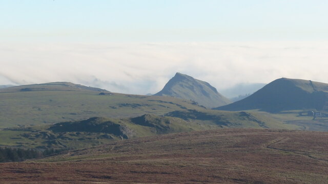
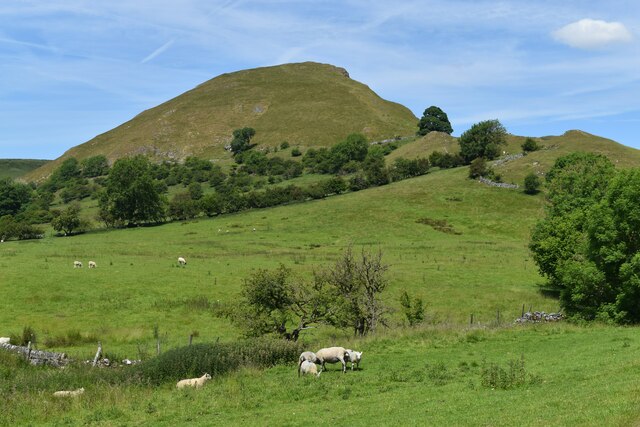
Dowel Dale, located in Derbyshire, England, is a picturesque valley nestled within the Peak District National Park. This idyllic valley is known for its stunning natural beauty, making it a popular destination for nature enthusiasts and leisure seekers alike.

The valley is characterized by its lush greenery, rolling hills, and meandering river, which flows through the heart of the dale. The river, known as the Dowel River, is renowned for its crystal-clear waters, making it a haven for trout fishing and a peaceful spot for picnics along its banks.

Dowel Dale is also home to a diverse range of wildlife, with visitors often spotting rabbits, deer, and various bird species as they explore the area. The valley is particularly beautiful in the spring, when an array of colorful wildflowers bloom, creating a vibrant and picturesque landscape.

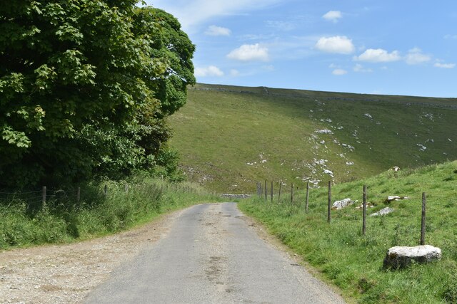
For those seeking outdoor activities, Dowel Dale offers numerous hiking trails and walking paths that cater to all skill levels. The trails wind through the valley, offering breathtaking views of the surrounding countryside and providing opportunities to discover hidden waterfalls and charming villages along the way.

In addition to its natural beauty, Dowel Dale is also home to quaint stone cottages and historic buildings that showcase the area's rich cultural heritage. The valley has inspired many artists and writers throughout the years, with its romantic charm and peaceful atmosphere serving as a muse for creativity.

Overall, Dowel Dale is a true gem in the heart of Derbyshire, offering visitors a chance to escape the hustle and bustle of everyday life and immerse themselves in the tranquility and natural splendor of this stunning valley.

If you have any feedback on the listing, please let us know in the comments section below.

Dowel Dale Images

Images are sourced within 2km of 53.210167/-1.8916588 or Grid Reference SK0768. Thanks to Geograph Open Source API. All images are credited.

Parkhouse Hill as seen from Axe Edge Trig Point One of the few hills visible during this cold air inversion. Chrome Hill is on the right.
Parkhouse Hill as seen from Axe Edge Trig Point
One of the few hills visible during this cold air inversion. Chrome Hill is on the right.
Parkhouse and Chrome Hills Looking southwest through the Parkhouse and Chrome Hills, near Earl Sterndale in the Derbyshire Peak District.

- image by Phil Brandon Hunter - philbhu.com - P1060685A
Parkhouse and Chrome Hills
Looking southwest through the Parkhouse and Chrome Hills, near Earl Sterndale in the Derbyshire Peak District. - image by Phil Brandon Hunter - philbhu.com - P1060685A
Hollinsclough Derbyshire Peaks The view northeast from south of Hollinsclough village, Derbyshire Peak District

- image by Phil Brandon Hunter - philbhu.com - P7230099A
Hollinsclough Derbyshire Peaks
The view northeast from south of Hollinsclough village, Derbyshire Peak District - image by Phil Brandon Hunter - philbhu.com - P7230099A
Hollinsclough Derbyshire Peaks Chrome Hill and Parkhouse Hill from the southwest, viewed from  southeast of Hollinsclough village

- image by Phil Brandon Hunter - philbhu.com - P7230106A
Hollinsclough Derbyshire Peaks
Chrome Hill and Parkhouse Hill from the southwest, viewed from southeast of Hollinsclough village - image by Phil Brandon Hunter - philbhu.com - P7230106A
Parkhouse Hill, seen from Glutton Bridge The tree and building are beside the track from Crowdicote.
Parkhouse Hill, seen from Glutton Bridge
The tree and building are beside the track from Crowdicote.
Parkhouse Hill
Parkhouse Hill
Chrome Hill
Chrome Hill
Cattle grid south of Dowall Hall In the pass between Chrome Hill and Parkhouse Hill.
Cattle grid south of Dowall Hall
In the pass between Chrome Hill and Parkhouse Hill.
Parkhouse Hill
Parkhouse Hill
Dowall Hall
Dowall Hall
View along the ridge of Chrome Hill to Parkhouse Hill Along the “dragon’s back” of these two limestone reef knolls.
View along the ridge of Chrome Hill to Parkhouse Hill
Along the “dragon’s back” of these two limestone reef knolls.
The Dove Valley from the summit of Chrome Hill Parkhouse Hill on the left.
The Dove Valley from the summit of Chrome Hill
Parkhouse Hill on the left.
Dowel Dale, shortly above Dowell Hall Both spellings as per Ordnance Survey. This section of the valley is a miniature limestone gorge.
Dowel Dale, shortly above Dowell Hall
Both spellings as per Ordnance Survey. This section of the valley is a miniature limestone gorge.
Dowel Dale Limestone valley complete with crags and caves.
Dowel Dale
Limestone valley complete with crags and caves.
Looking down Dowel Dale
Greensides
Greensides
Lane into Dowel Dale at Owl Hole The lane descends from this point to Dowall Hall through a miniature limestone valley, with crags and caves and a short gorge section at the lower end.
Lane into Dowel Dale at Owl Hole
The lane descends from this point to Dowall Hall through a miniature limestone valley, with crags and caves and a short gorge section at the lower end.
Chocolate lid signs I was expecting something agricultural but these signs are made from popular chocolate box lids!
Chocolate lid signs
I was expecting something agricultural but these signs are made from popular chocolate box lids!
Show me another place!

Dowel Dale is located at Grid Ref: SK0768 (Lat: 53.210167, Lng: -1.8916588)

Administrative County: Derbyshire

District: Derbyshire Dales

Police Authority: Derbyshire

What 3 Words

///uniforms.playfully.removers. Near Buxton, Derbyshire

Nearby Locations

Dowel Dale

Related Wikis

Chrome Hill

Chrome Hill is a limestone reef knoll in Derbyshire, England, in the upper Dove valley beside the border with Staffordshire, within the civil parish...

High Edge

High Edge is a limestone hill overlooking Harpur Hill, Buxton in Derbyshire, in the Peak District. The summit is 472 metres (1,549 ft) above sea level...

Hollins Hill

Hollins Hill is a gritstone hill in the Derbyshire Peak District near the village of Hollinsclough. The summit is 450 metres (1,480 ft) above sea level...

Parkhouse Hill

Parkhouse Hill is a small but distinctive hill in the Peak District National Park of the Hartington Middle Quarter civil parish, in the English county...

Nearby Amenities

Located within 500m of 53.210167,-1.8916588
Barrier: cattle_grid
Bicycle: yes
Foot: yes
Motorcar: yes
Motorcycle: yes
Source: survey
Lat/Long: 53.211316/-1.8960295
Note: Gate beside cattle grid presumably for horses etc to bypass cattle grid
Lat/Long: 53.2112952/-1.896058
Barrier: stile
Foot: yes
Note: Stile by cattle grid, enabling pedestrians to bypass the cattle grid
Lat/Long: 53.2113312/-1.8960037
Disused: yes
Man Made: mineshaft
Source: survey
Lat/Long: 53.2117732/-1.897069
Description: Known lead mining in this field. Fringing spoil heap visible on aerial imagery very characteristic
Historic: mine_shaft
Mineral: lead
Source: Bing
Lat/Long: 53.2134829/-1.8941654
Description: Known lead mining in this field. Fringing spoil heap visible on aerial imagery very characteristic
Historic: mine_shaft
Mineral: lead
Source: Bing
Lat/Long: 53.2140563/-1.8954314
Description: Known lead mining in this field. Fringing spoil heap visible on aerial imagery very characteristic
Historic: mine_shaft
Mineral: lead
Source: Bing
Lat/Long: 53.2140081/-1.8952222
Description: Known lead mining in this field. Fringing spoil heap visible on aerial imagery very characteristic
Historic: mine_shaft
Mineral: lead
Source: Bing
Lat/Long: 53.2139728/-1.8949969
Description: Known lead mining in this field. Fringing spoil heap visible on aerial imagery very characteristic
Historic: mine_shaft
Mineral: lead
Source: Bing
Lat/Long: 53.213833/-1.8942096
Description: Known lead mining in next field. Fringing spoil heap visible on aerial imagery very characteristic
Historic: mine_shaft
Mineral: lead
Source: Bing
Lat/Long: 53.2119023/-1.8934533
Description: Known lead mining in next field. Fringing spoil heap visible on aerial imagery very characteristic
Historic: mine_shaft
Mineral: lead
Source: Bing
Lat/Long: 53.2118702/-1.8935069
Description: Known lead mining in next field. Fringing spoil heap visible on aerial imagery very characteristic
Historic: mine_shaft
Mineral: lead
Source: Bing
Lat/Long: 53.211822/-1.8935767
Description: Known lead mining in next field. Fringing spoil heap visible on aerial imagery very characteristic
Historic: mine_shaft
Mineral: lead
Source: Bing
Lat/Long: 53.2119328/-1.8934104
Description: Known lead mining in next field. Fringing spoil heap visible on aerial imagery very characteristic
Historic: mine_shaft
Mineral: lead
Source: Bing
Lat/Long: 53.2119778/-1.8933433
Description: Known lead mining in next field. Fringing spoil heap visible on aerial imagery very characteristic
Historic: mine_shaft
Mineral: lead
Source: Bing
Lat/Long: 53.2102351/-1.8856348
Description: Known lead mining in next field. Fringing spoil heap visible on aerial imagery very characteristic
Historic: mine_shaft
Mineral: lead
Source: Bing
Lat/Long: 53.2099233/-1.8855515
tumulus
Archaeological Site: tumulus
Historic: archaeological_site
Source: OS Derbyshire XXII.SW, publ 1924
Lat/Long: 53.2130555/-1.8872334
Description: Known lead mining in next field. Fringing spoil heap visible on aerial imagery very characteristic
Historic: mine_shaft
Mineral: lead
Source: Bing
Lat/Long: 53.2109979/-1.885809
Description: Known lead mining in next field. Fringing spoil heap visible on aerial imagery very characteristic
Historic: mine_shaft
Mineral: lead
Source: Bing
Lat/Long: 53.209851/-1.8855193
Description: Known lead mining in next field. Fringing spoil heap visible on aerial imagery very characteristic
Historic: mine_shaft
Mineral: lead
Source: Bing
Lat/Long: 53.2115714/-1.8858412
Description: Known lead mining in next field. Fringing spoil heap visible on aerial imagery very characteristic
Historic: mine_shaft
Mineral: lead
Source: Bing
Lat/Long: 53.2111924/-1.885809
Description: Known lead mining in next field. Fringing spoil heap visible on aerial imagery very characteristic
Historic: mine_shaft
Mineral: lead
Source: Bing
Lat/Long: 53.2108502/-1.8857875
Description: Known lead mining in next field. Fringing spoil heap visible on aerial imagery very characteristic
Historic: mine_shaft
Mineral: lead
Source: Bing
Lat/Long: 53.21112/-1.8858117
Description: Known lead mining in this field. Fringing spoil heap visible on aerial imagery very characteristic
Historic: mine_shaft
Mineral: lead
Source: Bing
Lat/Long: 53.2134635/-1.8942325
Description: Known lead mining in this field. Fringing spoil heap visible on aerial imagery very characteristic
Historic: mine_shaft
Mineral: lead
Source: Bing
Lat/Long: 53.2139888/-1.8950747
Description: Known lead mining in this field. Fringing spoil heap visible on aerial imagery very characteristic
Historic: mine_shaft
Mineral: lead
Source: Bing
Lat/Long: 53.2137897/-1.8943961
Description: Known lead mining in this field. Fringing spoil heap visible on aerial imagery very characteristic
Historic: mine_shaft
Mineral: lead
Source: Bing
Lat/Long: 53.2134572/-1.8942888
Description: Known lead mining in this field. Fringing spoil heap visible on aerial imagery very characteristic
Historic: mine_shaft
Mineral: lead
Source: Bing
Lat/Long: 53.2140289/-1.8953375
lime kiln
Archaeological Site: lime_kiln
Historic: archaeological_site
Source: OS Derbyshire XXII.SW, publ 1924
Lat/Long: 53.2099747/-1.8935793
The data included in this document is from www.openstreetmap.org. The data is made available under ODbL.

Have you been to Dowel Dale?

Leave your review of Dowel Dale below (or comments, questions and feedback).