Listercombe Bottom
Valley in Gloucestershire Cotswold
England
Listercombe Bottom
![A walk around the Fosse Way [1] The minor road runs from the Fosse Way (A429) towards Coln St Dennis.
Starting at Fossebridge, where the Fosse Way descends precipitously to cross the River Coln, the walk gently ascends on a road and then a bridleway to meet a minor road which is part of the Salt Way. After using the Salt Way to cross the Fosse Way the route descends on footpaths and minor roads via Oxpens Farm and Stowell Mill to return to Fossebridge.](https://s2.geograph.org.uk/geophotos/06/99/49/6994958_d768d550.jpg)
Listercombe Bottom is a picturesque valley located in Gloucestershire, England. Nestled amidst the rolling hills of the Cotswolds, it is a site of outstanding natural beauty. The valley is characterized by its lush green meadows, dense woodlands, and a serene river that meanders through the landscape.
The valley is home to a diverse range of flora and fauna, making it a haven for nature enthusiasts. Wildflowers, such as bluebells and primroses, carpet the forest floor during springtime, creating a vibrant display of colors. The woodlands are dominated by ancient oak and beech trees, some of which are several centuries old.
The river that runs through Listercombe Bottom is known as the Listercombe Brook. It provides a habitat for various species of fish, including brown trout, and attracts a wide array of birdlife, including kingfishers and herons. Otters have also been spotted in the area, adding to the valley's ecological significance.
The valley offers a tranquil escape for visitors, with numerous walking and hiking trails that wind through the countryside. These paths allow visitors to explore the diverse landscape and take in the breathtaking views. Listercombe Bottom is also a popular spot for picnicking and photography, with many idyllic spots to relax and capture the natural beauty of the surroundings.
Overall, Listercombe Bottom in Gloucestershire is a hidden gem that showcases the beauty of the English countryside. Its unspoiled landscapes, diverse wildlife, and peaceful atmosphere make it a must-visit destination for nature lovers and those seeking a respite from the hustle and bustle of everyday life.
If you have any feedback on the listing, please let us know in the comments section below.
Listercombe Bottom Images
Images are sourced within 2km of 51.805447/-1.9014174 or Grid Reference SP0611. Thanks to Geograph Open Source API. All images are credited.
![A walk around the Fosse Way [2] The minor road runs from the Fosse Way (A429) towards Coln St Dennis. The telephone box in the distance is a K6 and there is a closer view at <a href="https://www.geograph.org.uk/photo/6994971">SP0811 : A walk around the Fosse Way [3]</a>.
Starting at Fossebridge, where the Fosse Way descends precipitously to cross the River Coln, the walk gently ascends on a road and then a bridleway to meet a minor road which is part of the Salt Way. After using the Salt Way to cross the Fosse Way the route descends on footpaths and minor roads via Oxpens Farm and Stowell Mill to return to Fossebridge.](https://s3.geograph.org.uk/geophotos/06/99/49/6994959_e9b82b35.jpg)
![A walk around the Fosse Way [3] A K6 telephone box, designed in 1935 by Sir Giles Gilbert Scott. The box is seen in context at <a href="https://www.geograph.org.uk/photo/6994959">SP0811 : A walk around the Fosse Way [2]</a>.
Starting at Fossebridge, where the Fosse Way descends precipitously to cross the River Coln, the walk gently ascends on a road and then a bridleway to meet a minor road which is part of the Salt Way. After using the Salt Way to cross the Fosse Way the route descends on footpaths and minor roads via Oxpens Farm and Stowell Mill to return to Fossebridge.](https://s3.geograph.org.uk/geophotos/06/99/49/6994971_072b3497.jpg)
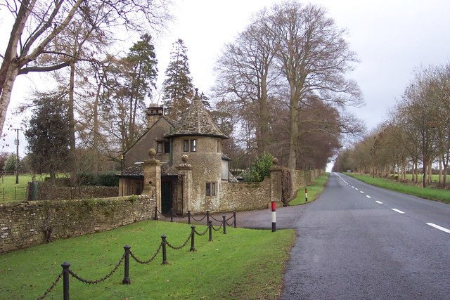
![A walk around the Fosse Way [4] The entrance driveway to The Manor, Coln St Dennis.
Starting at Fossebridge, where the Fosse Way descends precipitously to cross the River Coln, the walk gently ascends on a road and then a bridleway to meet a minor road which is part of the Salt Way. After using the Salt Way to cross the Fosse Way the route descends on footpaths and minor roads via Oxpens Farm and Stowell Mill to return to Fossebridge.](https://s2.geograph.org.uk/geophotos/06/99/49/6994982_71a491c9.jpg)
![A walk around the Fosse Way [5] The driveway to Manor Farm, a public bridleway, leaves the minor road.
Starting at Fossebridge, where the Fosse Way descends precipitously to cross the River Coln, the walk gently ascends on a road and then a bridleway to meet a minor road which is part of the Salt Way. After using the Salt Way to cross the Fosse Way the route descends on footpaths and minor roads via Oxpens Farm and Stowell Mill to return to Fossebridge.](https://s2.geograph.org.uk/geophotos/06/99/59/6995946_00b78739.jpg)
![A walk around the Fosse Way [6] The track leading to Manor Farm is also a public bridleway.
Starting at Fossebridge, where the Fosse Way descends precipitously to cross the River Coln, the walk gently ascends on a road and then a bridleway to meet a minor road which is part of the Salt Way. After using the Salt Way to cross the Fosse Way the route descends on footpaths and minor roads via Oxpens Farm and Stowell Mill to return to Fossebridge.](https://s3.geograph.org.uk/geophotos/06/99/59/6995947_3d389408.jpg)
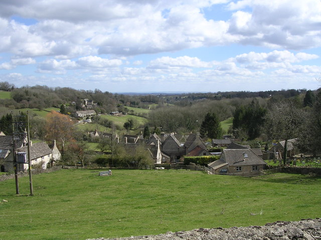
![A walk around the Fosse Way [59] The village of Yanworth, seen, across the fields from the minor road that is part of the long distance Monarch&#039;s Way. The village is part of the 6,000 acre Stowell Estate.
Starting at Fossebridge, where the Fosse Way descends precipitously to cross the River Coln, the walk gently ascends on a road and then a bridleway to meet a minor road which is part of the Salt Way. After using the Salt Way to cross the Fosse Way the route descends on footpaths and minor roads via Oxpens Farm and Stowell Mill to return to Fossebridge.](https://s2.geograph.org.uk/geophotos/06/99/74/6997474_1655c2e8.jpg)
![A walk around the Fosse Way [60] The long distance Monarch&#039;s Way follows the fork to the right towards Yanworth. The fork to the left leads to Fossbridge.
Starting at Fossebridge, where the Fosse Way descends precipitously to cross the River Coln, the walk gently ascends on a road and then a bridleway to meet a minor road which is part of the Salt Way. After using the Salt Way to cross the Fosse Way the route descends on footpaths and minor roads via Oxpens Farm and Stowell Mill to return to Fossebridge.](https://s3.geograph.org.uk/geophotos/06/99/74/6997487_43abd30b.jpg)
![A walk around the Fosse Way [61] A well built store shed in the angle between two roads.
Starting at Fossebridge, where the Fosse Way descends precipitously to cross the River Coln, the walk gently ascends on a road and then a bridleway to meet a minor road which is part of the Salt Way. After using the Salt Way to cross the Fosse Way the route descends on footpaths and minor roads via Oxpens Farm and Stowell Mill to return to Fossebridge.](https://s3.geograph.org.uk/geophotos/06/99/74/6997491_2ce06e81.jpg)
![A walk around the Fosse Way [62] A substantial stone built house alongside the minor road.
Starting at Fossebridge, where the Fosse Way descends precipitously to cross the River Coln, the walk gently ascends on a road and then a bridleway to meet a minor road which is part of the Salt Way. After using the Salt Way to cross the Fosse Way the route descends on footpaths and minor roads via Oxpens Farm and Stowell Mill to return to Fossebridge.](https://s2.geograph.org.uk/geophotos/06/99/74/6997494_a7cd7dac.jpg)
![A walk around the Fosse Way [63] Leaving the minor road, this footpath descends along the left bank of the River Coln to Fossbridge.
Starting at Fossebridge, where the Fosse Way descends precipitously to cross the River Coln, the walk gently ascends on a road and then a bridleway to meet a minor road which is part of the Salt Way. After using the Salt Way to cross the Fosse Way the route descends on footpaths and minor roads via Oxpens Farm and Stowell Mill to return to Fossebridge.](https://s0.geograph.org.uk/geophotos/06/99/74/6997496_2ff774b8.jpg)
![A walk around the Fosse Way [64] Leaving the minor road, this footpath ascends the slope to end near the main house of Stowell Park.
Starting at Fossebridge, where the Fosse Way descends precipitously to cross the River Coln, the walk gently ascends on a road and then a bridleway to meet a minor road which is part of the Salt Way. After using the Salt Way to cross the Fosse Way the route descends on footpaths and minor roads via Oxpens Farm and Stowell Mill to return to Fossebridge.](https://s2.geograph.org.uk/geophotos/06/99/74/6997498_f6c9c769.jpg)
![A walk around the Fosse Way [65] Near Stowell Mill this footpath leaves the minor road to &#039;cut the corner&#039; to the road to Yanworth.
Starting at Fossebridge, where the Fosse Way descends precipitously to cross the River Coln, the walk gently ascends on a road and then a bridleway to meet a minor road which is part of the Salt Way. After using the Salt Way to cross the Fosse Way the route descends on footpaths and minor roads via Oxpens Farm and Stowell Mill to return to Fossebridge.](https://s2.geograph.org.uk/geophotos/06/99/75/6997502_7d55648e.jpg)
![A walk around the Fosse Way [66] This former mill on the River Coln is Stowell Mill. Built in the late 18th century with later extensions to both sides. Constructed of coursed stone with dressed stone to the openings, all under a stone slate roof. Listed, grade II, with details at: <span class="nowrap"><a title="https://historicengland.org.uk/listing/the-list/list-entry/1152555" rel="nofollow ugc noopener" href="https://historicengland.org.uk/listing/the-list/list-entry/1152555">Link</a><img style="margin-left:2px;" alt="External link" title="External link - shift click to open in new window" src="https://s1.geograph.org.uk/img/external.png" width="10" height="10"/></span>
Starting at Fossebridge, where the Fosse Way descends precipitously to cross the River Coln, the walk gently ascends on a road and then a bridleway to meet a minor road which is part of the Salt Way. After using the Salt Way to cross the Fosse Way the route descends on footpaths and minor roads via Oxpens Farm and Stowell Mill to return to Fossebridge.](https://s1.geograph.org.uk/geophotos/06/99/75/6997505_8cbfd195.jpg)
![A walk around the Fosse Way [67] This former mill on the River Coln is Stowell Mill. Built in the late 18th century with later extensions to both sides. Constructed of coursed stone with dressed stone to the openings, all under a stone slate roof. Listed, grade II, with details at: <span class="nowrap"><a title="https://historicengland.org.uk/listing/the-list/list-entry/1152555" rel="nofollow ugc noopener" href="https://historicengland.org.uk/listing/the-list/list-entry/1152555">Link</a><img style="margin-left:2px;" alt="External link" title="External link - shift click to open in new window" src="https://s1.geograph.org.uk/img/external.png" width="10" height="10"/></span>
Starting at Fossebridge, where the Fosse Way descends precipitously to cross the River Coln, the walk gently ascends on a road and then a bridleway to meet a minor road which is part of the Salt Way. After using the Salt Way to cross the Fosse Way the route descends on footpaths and minor roads via Oxpens Farm and Stowell Mill to return to Fossebridge.](https://s2.geograph.org.uk/geophotos/06/99/83/6998390_cf89decc.jpg)
![A walk around the Fosse Way [68] The River Coln seen alongside Stowell Mill <a href="https://www.geograph.org.uk/photo/6998390">SP0812 : A walk around the Fosse Way [67]</a>. Another branch of the river flows under the mill.
Starting at Fossebridge, where the Fosse Way descends precipitously to cross the River Coln, the walk gently ascends on a road and then a bridleway to meet a minor road which is part of the Salt Way. After using the Salt Way to cross the Fosse Way the route descends on footpaths and minor roads via Oxpens Farm and Stowell Mill to return to Fossebridge.](https://s0.geograph.org.uk/geophotos/06/99/83/6998396_6699fdea.jpg)
![A walk around the Fosse Way [69] The Old Farmhouse, now three residences, is near to Stowell Mill <a href="https://www.geograph.org.uk/photo/6998390">SP0812 : A walk around the Fosse Way [67]</a>. Built, facing away from the minor road, in the late 18th century with later additions. Constructed of coursed limestone with dressed quoins and openings, all under a stone slate roof. Listed, grade II, with details at: <span class="nowrap"><a title="https://historicengland.org.uk/listing/the-list/list-entry/1090226" rel="nofollow ugc noopener" href="https://historicengland.org.uk/listing/the-list/list-entry/1090226">Link</a><img style="margin-left:2px;" alt="External link" title="External link - shift click to open in new window" src="https://s1.geograph.org.uk/img/external.png" width="10" height="10"/></span>
Starting at Fossebridge, where the Fosse Way descends precipitously to cross the River Coln, the walk gently ascends on a road and then a bridleway to meet a minor road which is part of the Salt Way. After using the Salt Way to cross the Fosse Way the route descends on footpaths and minor roads via Oxpens Farm and Stowell Mill to return to Fossebridge.](https://s1.geograph.org.uk/geophotos/06/99/83/6998397_8197d872.jpg)
![A walk around the Fosse Way [70] Leaving the minor road, this footpath descends along the right bank of the River Coln to Fossebridge.
Starting at Fossebridge, where the Fosse Way descends precipitously to cross the River Coln, the walk gently ascends on a road and then a bridleway to meet a minor road which is part of the Salt Way. After using the Salt Way to cross the Fosse Way the route descends on footpaths and minor roads via Oxpens Farm and Stowell Mill to return to Fossberidge.](https://s2.geograph.org.uk/geophotos/06/99/83/6998398_28b92a6b.jpg)
Listercombe Bottom is located at Grid Ref: SP0611 (Lat: 51.805447, Lng: -1.9014174)
Administrative County: Gloucestershire
District: Cotswold
Police Authority: Gloucestershire
What 3 Words
///utter.hairpin.producers. Near Northleach, Gloucestershire
Nearby Locations
Related Wikis

Stony Furlong Railway Cutting
Stony Furlong Railway Cutting (grid reference SP063106) is a 2.7-hectare (6.7-acre) geological Site of Special Scientific Interest in Gloucestershire,...
Chedworth Halt railway station
Chedworth Halt railway station was on the Midland and South Western Junction Railway in Gloucestershire. The station opened on 1 October 1892, 14 months...
Chedworth
Chedworth is a village and civil parish in Gloucestershire, southwest England, in the Cotswolds. It is known as the location of Chedworth Roman Villa,...

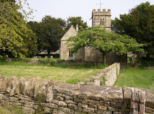
Church of St Andrew, Chedworth
The Anglican Church of St Andrew at Chedworth in the Cotswold District of Gloucestershire, England was built in the late 12th century. It is a grade I...
Yanworth
Yanworth is a small rural parish located in the county of Gloucestershire, England 14 miles south east of Cheltenham and 88 miles North West of London...

Church of St James, Coln St. Dennis
The Anglican Church of St James at Coln St. Dennis in the Cotswold District of Gloucestershire, England was built in the 12th century. It is a grade I...
Stowell Park
Stowell Park Estate is a 6,000-acre (24 km2) historic agricultural and sporting estate in the Cotswold Hills, Gloucestershire, England. The estate includes...
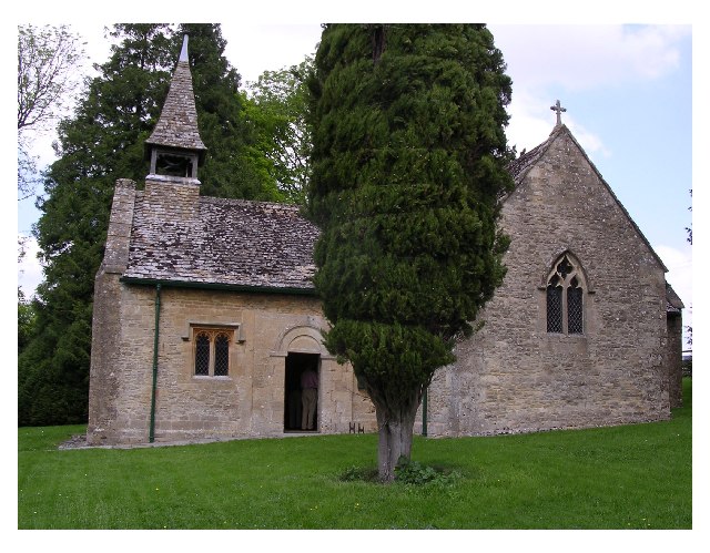
Church of St Leonard, Stowell Park
The Anglican Church of St Leonard at Stowell Park, in the Cotswold District of Gloucestershire, England was built in the 12th century. It is a grade I...
Nearby Amenities
Located within 500m of 51.805447,-1.9014174Have you been to Listercombe Bottom?
Leave your review of Listercombe Bottom below (or comments, questions and feedback).