Greta Valley
Valley in Yorkshire
England
Greta Valley
Greta Valley is a scenic valley located in Yorkshire, England. Situated in the northern part of the county, it forms part of the larger North Yorkshire Moors National Park, renowned for its stunning natural beauty and picturesque landscapes. The valley stretches for approximately 8 miles, starting from the village of Ingleby Greenhow in the west and extending to the town of Great Ayton in the east.
The valley is named after the River Leven (also known as the Greta), which flows through it, adding to its charm and allure. The river is flanked by rolling hills and verdant meadows, creating a captivating scenery that attracts visitors and nature enthusiasts alike. Greta Valley is a haven for wildlife, with a variety of bird species, small mammals, and plant life thriving in its diverse habitats.
The valley is dotted with several charming villages and hamlets, including Kildale, Battersby, and Newton under Roseberry. These settlements offer a glimpse into the traditional rural life of Yorkshire, with their quaint cottages, stone walls, and friendly atmosphere. Many of these villages have historic churches and buildings that showcase the area's rich heritage.
Greta Valley is also a popular destination for outdoor activities. The surrounding hills and moorland offer fantastic opportunities for hiking, cycling, and horseback riding, with numerous trails and paths to explore. Visitors can enjoy breathtaking views from prominent landmarks such as Roseberry Topping, a distinctive hill that stands at the western edge of the valley.
Overall, Greta Valley is a captivating destination that offers a perfect blend of natural beauty, cultural heritage, and outdoor recreation. Whether you seek tranquility or adventure, this Yorkshire valley has something to offer for everyone.
If you have any feedback on the listing, please let us know in the comments section below.
Greta Valley Images
Images are sourced within 2km of 54.508594/-2.0067623 or Grid Reference NY9912. Thanks to Geograph Open Source API. All images are credited.
![Bowes houses [1] Bowes Hall, The Street, is a large house built in the early and later 17th century. The house was refronted and extended in the early or mid 18th century, when the two right bays and the top storey were added. Constructed of rubble stone, the later work squared and coursed, under a slate roof. Many original internal features and fittings remain. Listed, grade II, with details at: <span class="nowrap"><a title="https://historicengland.org.uk/listing/the-list/list-entry/1121071" rel="nofollow ugc noopener" href="https://historicengland.org.uk/listing/the-list/list-entry/1121071">Link</a><img style="margin-left:2px;" alt="External link" title="External link - shift click to open in new window" src="https://s1.geograph.org.uk/img/external.png" width="10" height="10"/></span>
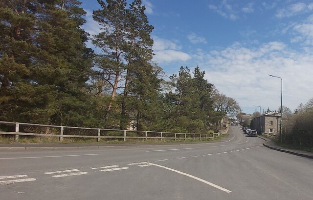
Bowes is a village in County Durham, some 14 miles northwest of Richmond and about 18½ miles due west of Darlington. Set on the north bank of the River Greta, the village was, until by-passed, astride the A66 trunk road. The Romans had a fort here, guarding the Stainmore pass over the Pennines, and their site was reused by the Normans who built a castle. The village grew around the castle, and the name Bowes is first mentioned in a charter of 1148.](https://s2.geograph.org.uk/geophotos/07/33/30/7333050_16951f3a.jpg)
![Bowes features [1] The garden walls, gate piers and gates of Bowes Hall <a href="https://www.geograph.org.uk/photo/7333050">NY9913 : Bowes houses [1]</a> were erected in the mid 18th century. Squared, coursed rubble stone walls and ashlar gate piers with mid 19th century iron gates. Listed, grade II, with details at: <span class="nowrap"><a title="https://historicengland.org.uk/listing/the-list/list-entry/1310919" rel="nofollow ugc noopener" href="https://historicengland.org.uk/listing/the-list/list-entry/1310919">Link</a><img style="margin-left:2px;" alt="External link" title="External link - shift click to open in new window" src="https://s1.geograph.org.uk/img/external.png" width="10" height="10"/></span>
Bowes is a village in County Durham, some 14 miles northwest of Richmond and about 18½ miles due west of Darlington. Set on the north bank of the River Greta, the village was, until by-passed, astride the A66 trunk road. The Romans had a fort here, guarding the Stainmore pass over the Pennines, and their site was reused by the Normans who built a castle. The village grew around the castle, and the name Bowes is first mentioned in a charter of 1148.](https://s0.geograph.org.uk/geophotos/07/33/30/7333052_37337ce4.jpg)
![Bowes houses [2] Numbers 1 and 2 The Street are a pair of houses built in the mid or late 18th century with later alterations. Constructed of rubble stone under an artificial stone roof. Listed, grade II, with details at: <span class="nowrap"><a title="https://historicengland.org.uk/listing/the-list/list-entry/1159738" rel="nofollow ugc noopener" href="https://historicengland.org.uk/listing/the-list/list-entry/1159738">Link</a><img style="margin-left:2px;" alt="External link" title="External link - shift click to open in new window" src="https://s1.geograph.org.uk/img/external.png" width="10" height="10"/></span>
Bowes is a village in County Durham, some 14 miles northwest of Richmond and about 18½ miles due west of Darlington. Set on the north bank of the River Greta, the village was, until by-passed, astride the A66 trunk road. The Romans had a fort here, guarding the Stainmore pass over the Pennines, and their site was reused by the Normans who built a castle. The village grew around the castle, and the name Bowes is first mentioned in a charter of 1148.](https://s1.geograph.org.uk/geophotos/07/33/30/7333053_35f3ac31.jpg)
![Bowes buildings [1] Bowes Club, formerly the Bowes and District Working Men&#039;s Club, in The Street, was built as a house in the early or mid 18th century. Constructed of sandstone ashlar under a stone slate roof. The link section on the left is in rubble stone. The paired sashes windows have small lunette windows above. Listed, grade II, with details at: <span class="nowrap"><a title="https://historicengland.org.uk/listing/the-list/list-entry/1323029" rel="nofollow ugc noopener" href="https://historicengland.org.uk/listing/the-list/list-entry/1323029">Link</a><img style="margin-left:2px;" alt="External link" title="External link - shift click to open in new window" src="https://s1.geograph.org.uk/img/external.png" width="10" height="10"/></span>
Bowes is a village in County Durham, some 14 miles northwest of Richmond and about 18½ miles due west of Darlington. Set on the north bank of the River Greta, the village was, until by-passed, astride the A66 trunk road. The Romans had a fort here, guarding the Stainmore pass over the Pennines, and their site was reused by the Normans who built a castle. The village grew around the castle, and the name Bowes is first mentioned in a charter of 1148.](https://s2.geograph.org.uk/geophotos/07/33/30/7333054_cccc0490.jpg)
![Bowes houses [3] Croft House and Sunny Croft, The Street, are a pair of houses built in the late 18th century and extended on both sides. Constructed of coursed rubble stone under a stone slate roof. Listed, for group value, grade II, with details at: <span class="nowrap"><a title="https://historicengland.org.uk/listing/the-list/list-entry/1121033" rel="nofollow ugc noopener" href="https://historicengland.org.uk/listing/the-list/list-entry/1121033">Link</a><img style="margin-left:2px;" alt="External link" title="External link - shift click to open in new window" src="https://s1.geograph.org.uk/img/external.png" width="10" height="10"/></span>
Bowes is a village in County Durham, some 14 miles northwest of Richmond and about 18½ miles due west of Darlington. Set on the north bank of the River Greta, the village was, until by-passed, astride the A66 trunk road. The Romans had a fort here, guarding the Stainmore pass over the Pennines, and their site was reused by the Normans who built a castle. The village grew around the castle, and the name Bowes is first mentioned in a charter of 1148.](https://s2.geograph.org.uk/geophotos/07/33/30/7333058_842b947b.jpg)
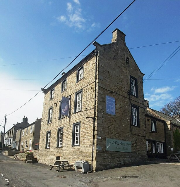
![Bowes buildings [2] The Ancient Unicorn Hotel, The Street, a former coaching inn, has a rear wing of the 17th century, in two builds, which was altered and refronted. The front block is mid 18th century. The front block is of squared, coursed sandstone with squared, coursed rubble stone returns and rusticated quoins, under a slate roof; stone chimney stacks. The rear wing is of squared, coursed rubble stone with partly stone slate and partly slate roofs. Some early internal features and fittings remain. The building is reputedly haunted. Listed, grade II, with details at: <span class="nowrap"><a title="https://historicengland.org.uk/listing/the-list/list-entry/1323027" rel="nofollow ugc noopener" href="https://historicengland.org.uk/listing/the-list/list-entry/1323027">Link</a><img style="margin-left:2px;" alt="External link" title="External link - shift click to open in new window" src="https://s1.geograph.org.uk/img/external.png" width="10" height="10"/></span>
Bowes is a village in County Durham, some 14 miles northwest of Richmond and about 18½ miles due west of Darlington. Set on the north bank of the River Greta, the village was, until by-passed, astride the A66 trunk road. The Romans had a fort here, guarding the Stainmore pass over the Pennines, and their site was reused by the Normans who built a castle. The village grew around the castle, and the name Bowes is first mentioned in a charter of 1148.](https://s1.geograph.org.uk/geophotos/07/33/30/7333093_40cd01c6.jpg)
![Bowes features [2] An elderly RAC &#039;Get You Home&#039; sign in The Street.
Bowes is a village in County Durham, some 14 miles northwest of Richmond and about 18½ miles due west of Darlington. Set on the north bank of the River Greta, the village was, until by-passed, astride the A66 trunk road. The Romans had a fort here, guarding the Stainmore pass over the Pennines, and their site was reused by the Normans who built a castle. The village grew around the castle, and the name Bowes is first mentioned in a charter of 1148.](https://s0.geograph.org.uk/geophotos/07/33/31/7333148_94906e75.jpg)
![Bowes houses [5] Cross House and Hill House, The Street, are a pair of houses, built circa 1840 with later alterations. Constructed of squared, coursed rubble stone under a stone slate roof. Listed, grade II, with details at: <span class="nowrap"><a title="https://historicengland.org.uk/listing/the-list/list-entry/1323028" rel="nofollow ugc noopener" href="https://historicengland.org.uk/listing/the-list/list-entry/1323028">Link</a><img style="margin-left:2px;" alt="External link" title="External link - shift click to open in new window" src="https://s1.geograph.org.uk/img/external.png" width="10" height="10"/></span>
Bowes is a village in County Durham, some 14 miles northwest of Richmond and about 18½ miles due west of Darlington. Set on the north bank of the River Greta, the village was, until by-passed, astride the A66 trunk road. The Romans had a fort here, guarding the Stainmore pass over the Pennines, and their site was reused by the Normans who built a castle. The village grew around the castle, and the name Bowes is first mentioned in a charter of 1148.](https://s2.geograph.org.uk/geophotos/07/33/31/7333162_b6a851c2.jpg)
![Bowes features [3] In the garden of Cross House on The Street <a href="https://www.geograph.org.uk/photo/7333162">NY9913 : Bowes houses [5]</a> is this base and stump of a cross shaft. Medieval, of sandstone. Listed, grade II, with details at: <span class="nowrap"><a title="https://historicengland.org.uk/listing/the-list/list-entry/1159719" rel="nofollow ugc noopener" href="https://historicengland.org.uk/listing/the-list/list-entry/1159719">Link</a><img style="margin-left:2px;" alt="External link" title="External link - shift click to open in new window" src="https://s1.geograph.org.uk/img/external.png" width="10" height="10"/></span>
Bowes is a village in County Durham, some 14 miles northwest of Richmond and about 18½ miles due west of Darlington. Set on the north bank of the River Greta, the village was, until by-passed, astride the A66 trunk road. The Romans had a fort here, guarding the Stainmore pass over the Pennines, and their site was reused by the Normans who built a castle. The village grew around the castle, and the name Bowes is first mentioned in a charter of 1148.](https://s1.geograph.org.uk/geophotos/07/33/42/7334253_0e313df9.jpg)
![Bowes buildings [3] The premises of Bowes Hutchinson&#039;s Church of England (Aided) School. A primary, co-educational school. Built in the late 19th century of rubble stone with ashlar dressings under a stone slate roof.
Bowes is a village in County Durham, some 14 miles northwest of Richmond and about 18½ miles due west of Darlington. Set on the north bank of the River Greta, the village was, until by-passed, astride the A66 trunk road. The Romans had a fort here, guarding the Stainmore pass over the Pennines, and their site was reused by the Normans who built a castle. The village grew around the castle, and the name Bowes is first mentioned in a charter of 1148.](https://s2.geograph.org.uk/geophotos/07/33/42/7334254_ce8ffd90.jpg)
Greta Valley is located at Grid Ref: NY9912 (Lat: 54.508594, Lng: -2.0067623)
Division: North Riding
Unitary Authority: County Durham
Police Authority: Durham
What 3 Words
///rear.supreme.unlocking. Near Bowes, Co. Durham
Nearby Locations
Related Wikis

Bowes
Bowes is a village in the historic county of Yorkshire and, since 1974, in the ceremonial county of County Durham, England. Located in the Pennine hills...

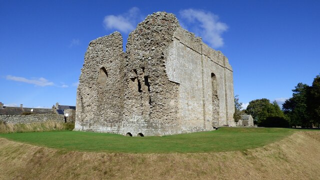
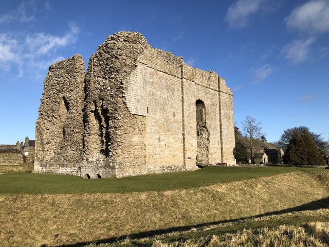
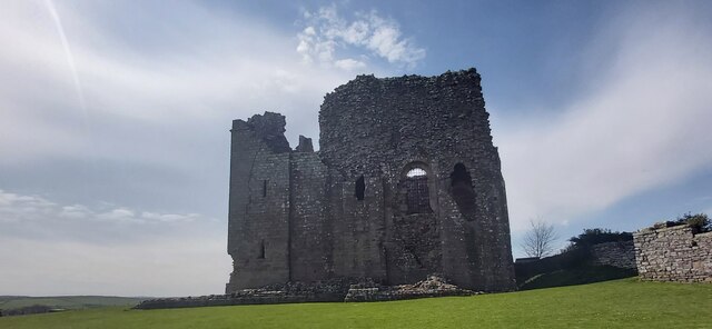
Bowes Castle
Bowes Castle is a medieval castle in the village of Bowes in County Durham, England. Built within the perimeter of the former Roman fort of Lavatrae, on...

Gilmonby
Gilmonby is a village in the Pennines in County Durham, England. it is situated a short distance to the south of Bowes, in the vicinity of Barnard Castle...

Bowes railway station
Bowes railway station was situated on the South Durham & Lancashire Union Railway between Barnard Castle and Kirkby Stephen East. == History == The line...
Nearby Amenities
Located within 500m of 54.508594,-2.0067623Have you been to Greta Valley?
Leave your review of Greta Valley below (or comments, questions and feedback).