Westwood Clough

Valley in Cheshire

England

Westwood Clough

Golf green on Harrop Edge Not part of a golf course. The public footpath follows the wall to the right but doesn't take you over the top of the hill which is up to the left.
Golf green on Harrop Edge Credit: Bill Boaden

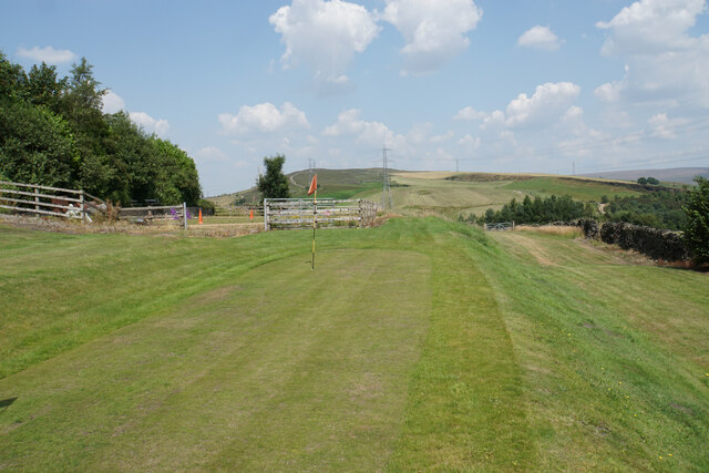
Westwood Clough is a picturesque valley located in the county of Cheshire, England. It is situated in the northern part of the county, near the town of Prestbury. The valley is known for its natural beauty, with rolling hills and lush greenery surrounding it.

Westwood Clough is characterized by its tranquil atmosphere and scenic views, making it a popular destination for nature lovers and hikers. The valley is home to a diverse range of flora and fauna, including various species of birds, mammals, and plant life. It offers a serene environment for wildlife enthusiasts to observe and appreciate nature.

The valley is also rich in history, with evidence of human settlement dating back to ancient times. There are remnants of old buildings and structures that provide glimpses into the past. Westwood Clough has been a source of inspiration for artists and writers, who have been captivated by its natural charm and timeless beauty.

Visitors to Westwood Clough can explore the numerous walking trails and footpaths that wind through the valley, offering breathtaking views of the surrounding countryside. The valley is also home to a number of streams and small waterfalls, adding to its charm.

In addition to its natural attractions, Westwood Clough is within close proximity to other popular tourist destinations in Cheshire. The nearby town of Prestbury offers a range of amenities, including shops, restaurants, and accommodations, making it a convenient base for exploring the area.

Overall, Westwood Clough is a hidden gem in Cheshire, offering visitors a chance to escape the hustle and bustle of everyday life and immerse themselves in the beauty of nature.

If you have any feedback on the listing, please let us know in the comments section below.

Westwood Clough Images

Images are sourced within 2km of 53.455043/-2.0387989 or Grid Reference SJ9795. Thanks to Geograph Open Source API. All images are credited.

Golf green on Harrop Edge Not part of a golf course. The public footpath follows the wall to the right but doesn't take you over the top of the hill which is up to the left.
Golf green on Harrop Edge
Not part of a golf course. The public footpath follows the wall to the right but doesn't take you over the top of the hill which is up to the left.
The western side of Harrop Edge Looking down towards Paddock Farm. Stockport Road and Tesco in Hattersley are both prominent down the slope. One day the new Mottram Bypass will cut across this view, though it has already been many years in discussion.
The western side of Harrop Edge
Looking down towards Paddock Farm. Stockport Road and Tesco in Hattersley are both prominent down the slope. One day the new Mottram Bypass will cut across this view, though it has already been many years in discussion.
Mass Vaccination Site (Tameside) As we approach the second winter of this Coronavirus era people are being given injections for Flu and Covid-19 at this Tameside vaccination site. This area was formerly the car park for British Gas who have moved to Stockport from this site on Hattersley Industrial Estate.
Mass Vaccination Site (Tameside)
As we approach the second winter of this Coronavirus era people are being given injections for Flu and Covid-19 at this Tameside vaccination site. This area was formerly the car park for British Gas who have moved to Stockport from this site on Hattersley Industrial Estate.
Hattersley Science and Technology Park Trees were felled and the land was cleared in July 2021 but since then no progress has been made on the construction of the Science Park. View of the site in 2021 <a title="https://www.geograph.org.uk/photo/6893918" href="https://www.geograph.org.uk/photo/6893918">Link</a>
Hattersley Science and Technology Park
Trees were felled and the land was cleared in July 2021 but since then no progress has been made on the construction of the Science Park. View of the site in 2021 Link
British Gas Depot car park 
The site on the Hattersley Industrial Estate was being used as a drive-in centre for the administration of Covid vaccine boosters.
British Gas Depot car park
The site on the Hattersley Industrial Estate was being used as a drive-in centre for the administration of Covid vaccine boosters.
Gallowsclough Road
Gallowsclough Road
Godley Brook The brook passes through private gardens. In the background is a folly castle <a href="https://www.geograph.org.uk/photo/7291391">SJ9695 : Brookbank Folly Castle</a>.
Godley Brook
The brook passes through private gardens. In the background is a folly castle SJ9695 : Brookbank Folly Castle.
Brookbank Folly Castle 
The Grade II listed <span class="nowrap"><a title="https://historicengland.org.uk/listing/the-list/list-entry/1268421?section=official-list-entry" rel="nofollow ugc noopener" href="https://historicengland.org.uk/listing/the-list/list-entry/1268421?section=official-list-entry">Link</a><img style="margin-left:2px;" alt="External link" title="External link - shift click to open in new window" src="https://s1.geograph.org.uk/img/external.png" width="10" height="10"/></span>  castellated folly castle overlooking Godley Brook lies in the back garden of Brookbank House.  The house was built in 1837 by Joseph Hibbert, the sixth of fourteen children of Randal Hibbert. The Hibbert family of Godley played an important part in the history of Hyde and its neighbourhood, figuring amongst the pioneers of the cotton industry.

The castle folly was probably built around the mid part of the 19th century. In the mid-1990s there were plans by the then owners to restore the building and open it up to the public. <span class="nowrap"><a title="http://hydonian.blogspot.co.uk/2011/12/brookbank-house-castle-folly.html" rel="nofollow ugc noopener" href="http://hydonian.blogspot.co.uk/2011/12/brookbank-house-castle-folly.html">Link</a><img style="margin-left:2px;" alt="External link" title="External link - shift click to open in new window" src="https://s1.geograph.org.uk/img/external.png" width="10" height="10"/></span>

Now it belongs to the Brookbank Day Nursery <a href="https://www.geograph.org.uk/photo/2436720">SJ9594 : Brookbank Nursery</a> and public access to the folly is not permitted. It can however be viewed from the footpath on the North side of the Godley Brook.
Brookbank Folly Castle
The Grade II listed LinkExternal link castellated folly castle overlooking Godley Brook lies in the back garden of Brookbank House. The house was built in 1837 by Joseph Hibbert, the sixth of fourteen children of Randal Hibbert. The Hibbert family of Godley played an important part in the history of Hyde and its neighbourhood, figuring amongst the pioneers of the cotton industry. The castle folly was probably built around the mid part of the 19th century. In the mid-1990s there were plans by the then owners to restore the building and open it up to the public. LinkExternal link Now it belongs to the Brookbank Day Nursery SJ9594 : Brookbank Nursery and public access to the folly is not permitted. It can however be viewed from the footpath on the North side of the Godley Brook.
Mottram Road 
The A57 towards Hyde.

The fourth house along on the right is  the Grade II listed   <span class="nowrap"><a title="https://historicengland.org.uk/listing/the-list/list-entry/1268420?section=official-list-entry" rel="nofollow ugc noopener" href="https://historicengland.org.uk/listing/the-list/list-entry/1268420?section=official-list-entry">Link</a><img style="margin-left:2px;" alt="External link" title="External link - shift click to open in new window" src="https://s1.geograph.org.uk/img/external.png" width="10" height="10"/></span> Brookbank House that was built in 1837 by the local Hibbert family. It is now used as a day nursery.
Mottram Road
The A57 towards Hyde. The fourth house along on the right is the Grade II listed LinkExternal link Brookbank House that was built in 1837 by the local Hibbert family. It is now used as a day nursery.
Hattersley Station 
The Northern service to Manchester Piccadilly is just about to depart.
Hattersley Station
The Northern service to Manchester Piccadilly is just about to depart.
Hattersley Station EMU 323225 leaving Hattersley for Manchester Piccadilly.
Hattersley Station
EMU 323225 leaving Hattersley for Manchester Piccadilly.
Hattersley Station The overbridge at Hattersley Station.
Hattersley Station
The overbridge at Hattersley Station.
Hattersley Station Steps down to the platform from the overbridge.
Hattersley Station
Steps down to the platform from the overbridge.
Hattersley Community Garden 
The Friends of Hattersley Station   created a community garden and a meeting place outside the station in 2015 <a href="https://www.geograph.org.uk/photo/4578737">SJ9794 : Hattersley Station Forecourt</a>.
Hattersley Community Garden
The Friends of Hattersley Station created a community garden and a meeting place outside the station in 2015 SJ9794 : Hattersley Station Forecourt.
Entrance to Hattersley Station 
Improvement works at Hattersley Station were completed in February 2023. The £750,000 upgrade  includes a new ticket office, waiting area, grab rails and audio descriptions for visually-impaired customers as well as a new fully accessible toilet  which includes baby changing, grab rails and an audio description for customers with visual impairments. 

Access to the platform however is still via an overbridge <a href="https://www.geograph.org.uk/photo/7429173">SJ9794 : Hattersley Station</a> and steps <a href="https://www.geograph.org.uk/photo/7429352">SJ9794 : Hattersley Station</a>.
Entrance to Hattersley Station
Improvement works at Hattersley Station were completed in February 2023. The £750,000 upgrade includes a new ticket office, waiting area, grab rails and audio descriptions for visually-impaired customers as well as a new fully accessible toilet which includes baby changing, grab rails and an audio description for customers with visual impairments. Access to the platform however is still via an overbridge SJ9794 : Hattersley Station and steps SJ9794 : Hattersley Station.
Project Solar  Stadium Formerly known as Ewen Fields. The home of Hyde United F.C.

A brief history of the club from 1885-2015 can be found Old Hyde: <span class="nowrap"><a title="https://oldhyde.blogspot.com/2010/09/a-brief-history-of-hyde-united-fc.html" rel="nofollow ugc noopener" href="https://oldhyde.blogspot.com/2010/09/a-brief-history-of-hyde-united-fc.html">Link</a><img style="margin-left:2px;" alt="External link" title="External link - shift click to open in new window" src="https://s1.geograph.org.uk/img/external.png" width="10" height="10"/></span>
Project Solar Stadium
Formerly known as Ewen Fields. The home of Hyde United F.C. A brief history of the club from 1885-2015 can be found Old Hyde: LinkExternal link
Project Solar Stadium Formerly known as Ewen Fields. The home of Hyde United F.C.

A brief history of the club from 1885-2015 can be found at Old Hyde: <span class="nowrap"><a title="https://oldhyde.blogspot.com/2010/09/a-brief-history-of-hyde-united-fc.html?" rel="nofollow ugc noopener" href="https://oldhyde.blogspot.com/2010/09/a-brief-history-of-hyde-united-fc.html?">Link</a><img style="margin-left:2px;" alt="External link" title="External link - shift click to open in new window" src="https://s1.geograph.org.uk/img/external.png" width="10" height="10"/></span>
Project Solar Stadium
Formerly known as Ewen Fields. The home of Hyde United F.C. A brief history of the club from 1885-2015 can be found at Old Hyde: LinkExternal link
Ewen Villa 
Ewen Villa is a large house at the top of Villiers Street, dated 1878. Now a house of multiple occupancy.
Ewen Villa
Ewen Villa is a large house at the top of Villiers Street, dated 1878. Now a house of multiple occupancy.
Show me another place!

Westwood Clough is located at Grid Ref: SJ9795 (Lat: 53.455043, Lng: -2.0387989)

Unitary Authority: Tameside

Police Authority: Greater Manchester

What 3 Words

///hydration.honestly.verge. Near Hyde, Manchester

Nearby Locations

Westwood Clough

Related Wikis

Mottram Tunnel

The Mottram Tunnel (Mottram in Longdendale) is a tunnel carrying drinking water by gravity from Arnfield Reservoir, Tintwistle, Derbyshire, in the valley...

Godley Reservoir

The Godley Reservoir is a reservoir in Godley, Hyde, Greater Manchester. It was completed in 1851, as a critical part of the Longdendale Chain project...

Godley East railway station

Godley East was a railway station in the Godley area of Hyde, Tameside, Greater Manchester, on the Woodhead Line. == Early history == On 17 November 1841...

Hattersley

Hattersley is an area of Tameside, Greater Manchester, England; it is located 4 miles (6.4 km) west of Glossop and 10 miles (16 km) east of Manchester...

Hattersley railway station

Hattersley railway station serves the Hattersley housing estate in Tameside, Greater Manchester, England. The station is 9 miles (14 km) east of Manchester...

Godley railway station

Godley railway station serves the Godley area of Hyde, Tameside, Greater Manchester, England. It is 8+1⁄2 miles (13.7 km) east of Manchester Piccadilly...

Shaw Hall factory

Shaw Hall factory was a 19th century cotton mill in lower Matley, Hyde, Greater Manchester in which nearly 200 people worked. The mill is marked as Shawhall...

Hyde Godley (ward)

Hyde Godley is an electoral ward of Tameside, England. It is represented in Westminster by Jonathan Reynolds Labour Co-operative MP for Stalybridge and...

Nearby Amenities

Located within 500m of 53.455043,-2.0387989
Pub
Harehill Tavern
Lat/Long: 53.45135/-2.0403302
Barrier: stile
Lat/Long: 53.4570689/-2.0332764
Barrier: bollard
Lat/Long: 53.4524712/-2.0448191
Bus Stop
Underwood Road/Honiton Avenue
Bus: yes
Naptan AtcoCode: 1800EH37621
Naptan Bearing: E
Naptan CommonName: Underwood Road/Honiton Avenue
Naptan Indicator: Nr Open Land
Naptan Landmark: NR OPEN LAND
Naptan NaptanCode: mandgawg
Naptan PlusbusZoneRef: MNCRPIC
Naptan ShortCommonName: Honiton Avenue
Naptan Street: UNDERWOOD ROAD
Naptan Verified: no
Network: TfGM
Public Transport: platform
Source: naptan_import
Lat/Long: 53.4517922/-2.0369234
Bus Stop
Underwood Road/Honiton Avenue
Bus: yes
Naptan AtcoCode: 1800EH37631
Naptan Bearing: W
Naptan CommonName: Underwood Road/Honiton Avenue
Naptan Indicator: Op House 29
Naptan Landmark: OP HOUSE 29
Naptan NaptanCode: mandgawj
Naptan PlusbusZoneRef: MNCRPIC
Naptan ShortCommonName: Honiton Avenue
Naptan Street: UNDERWOOD ROAD
Naptan Verified: no
Network: TfGM
Public Transport: platform
Source: naptan_import
Lat/Long: 53.4516841/-2.0377816
Bus Stop
Underwood Road/Hattersley Road West
Bus: yes
Naptan AtcoCode: 1800EH37641
Naptan Bearing: E
Naptan CommonName: Underwood Road/Hattersley Road West
Naptan Indicator: O/s House 1
Naptan Landmark: HOUSE 1
Naptan NaptanCode: mandgawm
Naptan PlusbusZoneRef: MNCRPIC
Naptan ShortCommonName: Hattersley Rd Wst
Naptan Street: UNDERWOOD ROAD
Naptan Verified: no
Network: TfGM
Public Transport: platform
Source: naptan_import
Lat/Long: 53.4517461/-2.0403416
Bus Stop
Hattersley, Hattersley Road West / near Mottram Road
Bus: yes
Naptan AtcoCode: 1800EH37651
Naptan Bearing: S
Naptan CommonName: Hattersley Road West/Mottram Road
Naptan Indicator: Nr Open Land
Naptan Landmark: NR OPEN LAND
Naptan NaptanCode: mandgawp
Naptan PlusbusZoneRef: MNCRPIC
Naptan ShortCommonName: Mottram Road
Naptan Street: Hattersley Road W
Naptan Verified: no
Network: TfGM
Operator: TfGM
Public Transport: platform
Source: naptan_import
Lat/Long: 53.453418/-2.0404787
Bus Stop
Hattersley, Hattersley Road West / opposite Underwood Road
Bus: yes
Naptan AtcoCode: 1800EH37661
Naptan Bearing: N
Naptan CommonName: Hattersley Road West/Underwood Road
Naptan Indicator: Op House 25
Naptan Landmark: HOUSE 24
Naptan NaptanCode: mandgawt
Naptan PlusbusZoneRef: MNCRPIC
Naptan ShortCommonName: Underwood Road
Naptan Street: Hattersley Road W
Naptan Verified: no
Network: TfGM
Operator: TfGM
Public Transport: platform
Source: naptan_import
Lat/Long: 53.4522224/-2.040854
Bus Stop
Hattersley, Hattersley Road West / near Underwood Road
Bus: yes
Naptan AtcoCode: 1800EH37671
Naptan Bearing: S
Naptan CommonName: Hattersley Road West/Underwood Road
Naptan Indicator: Harevill Tavern
Naptan Landmark: HAREHILL TAVERN
Naptan NaptanCode: mandgdad
Naptan Notes: INDICATOR AMENDED
Naptan PlusbusZoneRef: MNCRPIC
Naptan ShortCommonName: Underwood Road
Naptan Street: Hattersley Road W
Naptan Verified: no
Network: TfGM
Operator: TfGM
Public Transport: platform
Source: naptan_import
Lat/Long: 53.4514404/-2.0406274
Bus Stop
Hattersley, Mottram Road / near Hattersley Road West
Bus: yes
Naptan AtcoCode: 1800EH37941
Naptan Bearing: W
Naptan CommonName: Mottram Road/Hattersley Road West
Naptan Indicator: Nr Grass Land
Naptan Landmark: NR GRASS LAND
Naptan NaptanCode: mandgdmt
Naptan PlusbusZoneRef: MNCRPIC
Naptan ShortCommonName: Hattersley Rd Wst
Naptan Street: MOTTRAM ROAD
Naptan Verified: no
Network: TfGM
Operator: TfGM
Public Transport: platform
Source: naptan_import
Lat/Long: 53.4537144/-2.0410964
Barrier: bollard
Lat/Long: 53.4512705/-2.0416675
Barrier: bollard
Lat/Long: 53.4513799/-2.0416696
Generator Method: photovoltaic
Generator Output Electricity: yes
Generator Source: solar
Generator Type: solar_photovoltaic_panel
Location: roof
Power: generator
Lat/Long: 53.4525107/-2.0344255
Generator Method: photovoltaic
Generator Output Electricity: yes
Generator Source: solar
Generator Type: solar_photovoltaic_panel
Location: roof
Power: generator
Lat/Long: 53.4528461/-2.0337549
Generator Method: photovoltaic
Generator Output Electricity: yes
Generator Source: solar
Generator Type: solar_photovoltaic_panel
Location: roof
Power: generator
Lat/Long: 53.452486/-2.0367777
Generator Method: photovoltaic
Generator Output Electricity: yes
Generator Source: solar
Generator Type: solar_photovoltaic_panel
Location: roof
Power: generator
Lat/Long: 53.4518136/-2.0398703
Generator Method: photovoltaic
Generator Output Electricity: yes
Generator Source: solar
Generator Type: solar_photovoltaic_panel
Location: roof
Power: generator
Lat/Long: 53.4515069/-2.0395913
Generator Method: photovoltaic
Generator Output Electricity: yes
Generator Source: solar
Generator Type: solar_photovoltaic_panel
Location: roof
Power: generator
Lat/Long: 53.4513759/-2.0412623
Generator Method: photovoltaic
Generator Output Electricity: yes
Generator Source: solar
Generator Type: solar_photovoltaic_panel
Location: roof
Power: generator
Lat/Long: 53.4528869/-2.0419731
Post Box
Operator: Royal Mail
Operator Wikidata: Q638098
Post Box Type: pillar
Source: Bing Streetside
Lat/Long: 53.4512401/-2.0405982
Power: pole
Lat/Long: 53.4580299/-2.043606
Power: pole
Lat/Long: 53.4573056/-2.0405544
Power: pole
Lat/Long: 53.4576718/-2.0428507
Power: pole
Lat/Long: 53.4572726/-2.0420728
Power: pole
Lat/Long: 53.4573154/-2.0411759
Power: pole
Lat/Long: 53.4557647/-2.039587
Power: pole
Lat/Long: 53.4556396/-2.0382794
Power: pole
Lat/Long: 53.4554866/-2.0368224
Power: pole
Lat/Long: 53.4553316/-2.0353758
Power: pole
Lat/Long: 53.455317/-2.0342119
Power: pole
Lat/Long: 53.4552725/-2.0327712
Power: pole
Lat/Long: 53.4552489/-2.0314706
Power: pole
Lat/Long: 53.4560867/-2.0424826
Power: pole
Lat/Long: 53.4565161/-2.0443226
Communication Mobile Phone: yes
Man Made: mast
Tower Type: communication
Lat/Long: 53.4556586/-2.0399042
Power: pole
Lat/Long: 53.4576853/-2.0386764
Power: pole
Lat/Long: 53.4579895/-2.0374252
Power: pole
Lat/Long: 53.458079/-2.0362262
Power: pole
Lat/Long: 53.4581189/-2.0355946
Power: pole
Lat/Long: 53.4582043/-2.0343943
The data included in this document is from www.openstreetmap.org. The data is made available under ODbL.

Have you been to Westwood Clough?

Leave your review of Westwood Clough below (or comments, questions and feedback).