Clay Roads Clough

Valley in Lancashire

England

Clay Roads Clough

Boundary stone on Todmorden Road Marks the division of the old Littleborough Urban District and the Borough of Todmorden. Now the local authorities are Rochdale and Calderdale respectively. Or, in tribal terms, the boundary between Lancashire and Yorkshire.
Boundary stone on Todmorden Road Credit: michael ely

The requested URL returned error: 429 Too Many Requests

If you have any feedback on the listing, please let us know in the comments section below.

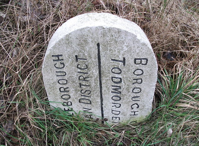
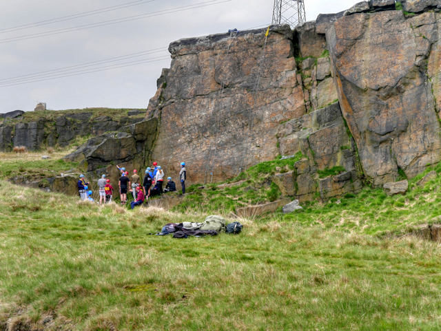
Clay Roads Clough Images

Images are sourced within 2km of 53.676197/-2.0655551 or Grid Reference SD9519. Thanks to Geograph Open Source API. All images are credited.

Boundary stone on Todmorden Road Marks the division of the old Littleborough Urban District and the Borough of Todmorden. Now the local authorities are Rochdale and Calderdale respectively. Or, in tribal terms, the boundary between Lancashire and Yorkshire.
Boundary stone on Todmorden Road
Marks the division of the old Littleborough Urban District and the Borough of Todmorden. Now the local authorities are Rochdale and Calderdale respectively. Or, in tribal terms, the boundary between Lancashire and Yorkshire.
Longlees Lock, Rochdale Canal Lock no 36 and the start of the summit pound.
Longlees Lock, Rochdale Canal
Lock no 36 and the start of the summit pound.
Higher Chelburn Reservoir from Leach Hill
The dam at Higher Chelburn Reservoir
Towards Light Hazzles Clough and Chelburn Moor
Light Hazzles Farm across the infant River Roch
Light Hazzles Farm
Light Hazzles Farm
Byron Edge Powerlines crossing Byron Edge, seen from Turvin Road.
Byron Edge
Powerlines crossing Byron Edge, seen from Turvin Road.
Cow Head The Pennine Way running alongside Cow Head Drain at Vow Head.
Cow Head
The Pennine Way running alongside Cow Head Drain at Vow Head.
Rochdale Way The Rochdale Way atop the dam of Light Hazzles Reservoir.
Rochdale Way
The Rochdale Way atop the dam of Light Hazzles Reservoir.
Pennine Way The Pennine Way running alongside Cow Head Drain.
Pennine Way
The Pennine Way running alongside Cow Head Drain.
Pennine Way at Utley Edge The Pennine Way is a National Trail in England, with a small section in Scotland. The trail runs 267 miles from Edale, in the northern Derbyshire Peak District, north through the Yorkshire Dales and the Northumberland National Park and ends at Kirk Yetholm, just inside the Scottish border. The path runs along the Pennine hills, sometimes described as the "backbone of England". Although not the United Kingdom's longest National Trail, it is according to the Ramblers' Association "one of Britain's best known and toughest".
Pennine Way at Utley Edge
The Pennine Way is a National Trail in England, with a small section in Scotland. The trail runs 267 miles from Edale, in the northern Derbyshire Peak District, north through the Yorkshire Dales and the Northumberland National Park and ends at Kirk Yetholm, just inside the Scottish border. The path runs along the Pennine hills, sometimes described as the "backbone of England". Although not the United Kingdom's longest National Trail, it is according to the Ramblers' Association "one of Britain's best known and toughest".
Stone Arch Bridge over Cow Head Drain Narrow stone footbridge at the side of the Pennine Way.
Stone Arch Bridge over Cow Head Drain
Narrow stone footbridge at the side of the Pennine Way.
Boulders at Utley Edge
The Rain Stone, Cows' Mouth Quarry A short walk (just over a mile) along the Pennine Way from <a href="https://www.geograph.org.uk/photo/4939112">SD9617 : The White House on Halifax Road</a> takes you to this wind-eroded rock outcrop where Simon Armitage's poem, Rain, is carved near the base of the rocks on the left hand side (barely visible) in this photograph. For a close up view, see John Illingworth’s photo <a href="https://www.geograph.org.uk/photo/3149349">SD9619 : The Rain Stone - one of the Stanza Stones - close-up</a>.  The Rain Stone is one of a series of seven Stanza Stones (<span class="nowrap"><a title="http://www.kirklees.gov.uk/leisure/countryside/pdf/routes/stanzastonestrailguide.pdf" rel="nofollow ugc noopener" href="http://www.kirklees.gov.uk/leisure/countryside/pdf/routes/stanzastonestrailguide.pdf">Link</a><img style="margin-left:2px;" alt="External link" title="External link - shift click to open in new window" src="https://s1.geograph.org.uk/img/external.png" width="10" height="10"/></span> Stanza Stones Trail Guide) each with one of Simon Armitage’s poems carved on it.
The Rain Stone, Cows' Mouth Quarry
A short walk (just over a mile) along the Pennine Way from SD9617 : The White House on Halifax Road takes you to this wind-eroded rock outcrop where Simon Armitage's poem, Rain, is carved near the base of the rocks on the left hand side (barely visible) in this photograph. For a close up view, see John Illingworth’s photo SD9619 : The Rain Stone - one of the Stanza Stones - close-up. The Rain Stone is one of a series of seven Stanza Stones (LinkExternal link Stanza Stones Trail Guide) each with one of Simon Armitage’s poems carved on it.
Climbers at Cow's Mouth Quarry Former quarry site next to the Pennine Way at Utley Edge. Popular site with rock climbers.
Climbers at Cow's Mouth Quarry
Former quarry site next to the Pennine Way at Utley Edge. Popular site with rock climbers.
Cow's Mouth Quarry, The Rain Stone Another view of <a href="https://www.geograph.org.uk/photo/4982622">SD9619 : The Rain Stone, Cows' Mouth Quarry</a>. Taken from a few yards further along the path, this view shows the unusual shape created by the wind erosion.
Cow's Mouth Quarry, The Rain Stone
Another view of SD9619 : The Rain Stone, Cows' Mouth Quarry. Taken from a few yards further along the path, this view shows the unusual shape created by the wind erosion.
Pylons and Turbines Looking westwards from the Pennine Way, along the line of pylons crossing Chelburn Moor. The turbines of the Scout Moor Wind Farm can be seen in the distance.
Pylons and Turbines
Looking westwards from the Pennine Way, along the line of pylons crossing Chelburn Moor. The turbines of the Scout Moor Wind Farm can be seen in the distance.
Show me another place!

Clay Roads Clough is located at Grid Ref: SD9519 (Lat: 53.676197, Lng: -2.0655551)

Unitary Authority: Rochdale

Police Authority: Greater Manchester

What 3 Words

///defaults.hypnotist.engulfing. Near Walsden, West Yorkshire

Related Wikis

Summit Tunnel fire

The Summit Tunnel fire occurred on 20 December 1984, when a dangerous goods train caught fire while passing through the Summit Tunnel on the railway line...

Summit Tunnel

Summit Tunnel in England is one of the world's oldest railway tunnels. It was constructed between 1838 and 1841 by the Manchester and Leeds Railway Company...

Calderbrook

Calderbrook ( KAWL-dər-bruuk) is a village within the Metropolitan Borough of Rochdale, in Greater Manchester, England. It was originally part of the township...

Blackstone Edge Reservoir

Blackstone Edge Reservoir is a reservoir in the Metropolitan Borough of Rochdale, Greater Manchester, England. It is close to Blackstone Edge, from which...

Nearby Amenities

Located within 500m of 53.676197,-2.0655551
Design: barrel
Power: tower
Lat/Long: 53.6723613/-2.0650859
Design: barrel
Power: tower
Lat/Long: 53.6727441/-2.0689026
The data included in this document is from www.openstreetmap.org. The data is made available under ODbL.

Have you been to Clay Roads Clough?

Leave your review of Clay Roads Clough below (or comments, questions and feedback).