Hayles Clough

Valley in Cheshire

England

Hayles Clough

Hollin Hall Hotel, Bollington
Hollin Hall Hotel, Bollington Credit: Mark Anderson

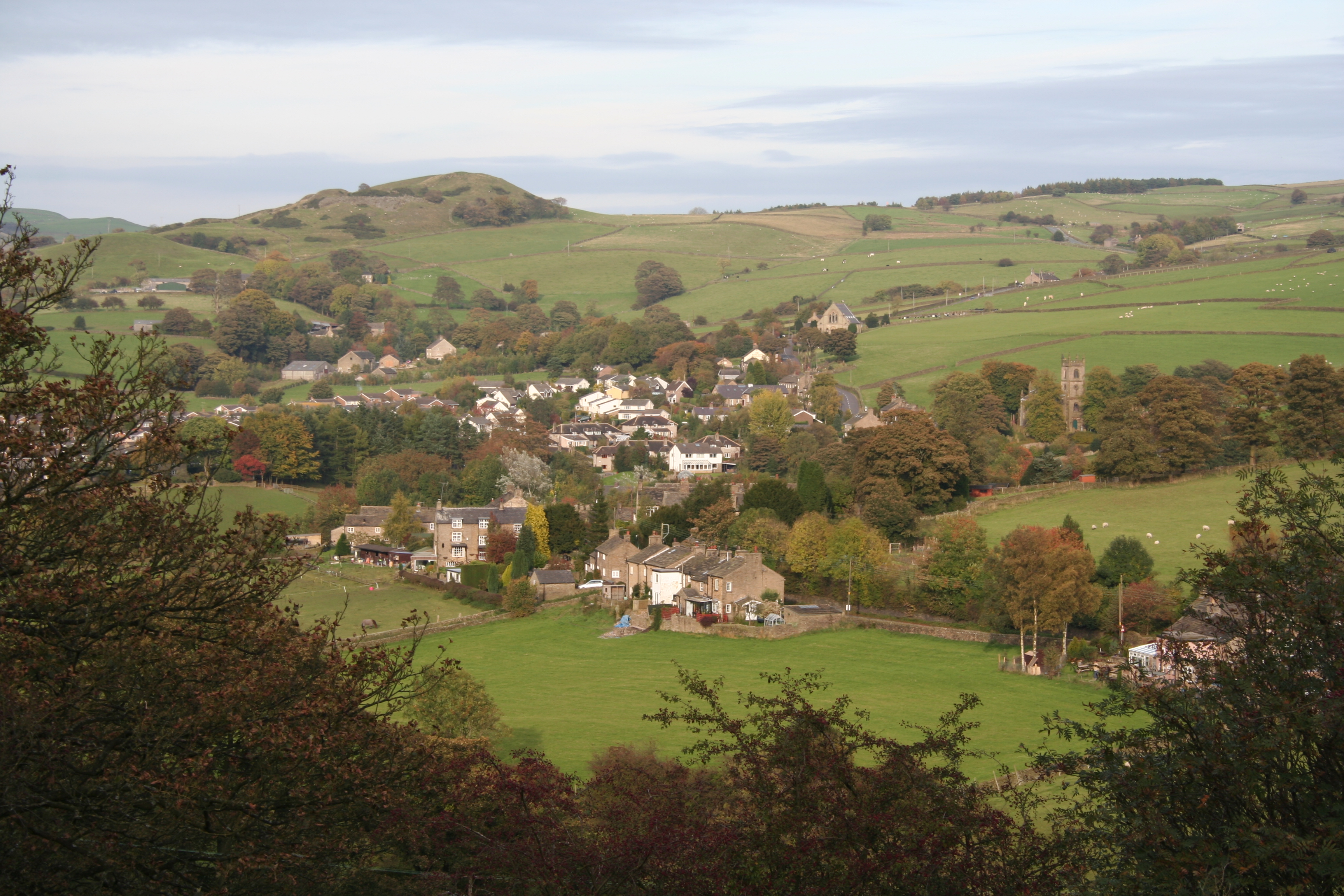
Hayles Clough is a picturesque valley located in the county of Cheshire, England. Nestled amidst the rolling hills and countryside, this charming valley offers stunning natural beauty and a peaceful atmosphere. It is situated in the southern part of Cheshire, near the town of Macclesfield.

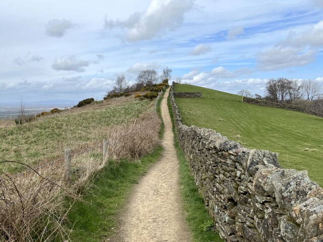
The main feature of Hayles Clough is the meandering stream that runs through it. This stream originates from the nearby hills and flows gently, creating a soothing ambiance. The valley is flanked by lush green fields and is adorned with a variety of trees, including oak and beech. This rich vegetation provides a habitat for numerous bird species and small animals, making it a haven for nature enthusiasts and birdwatchers.

Hayles Clough is often frequented by hikers and walkers who enjoy exploring the scenic trails that wind through the valley. These trails offer breathtaking views of the surrounding countryside and provide an opportunity to immerse oneself in nature. The valley also boasts a number of picnic spots, where visitors can relax and enjoy the tranquility of the surroundings.

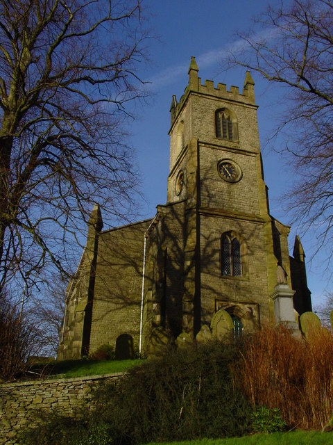
In addition to its natural beauty, Hayles Clough is also rich in history. The area has evidence of human settlement dating back thousands of years, with archaeological finds including ancient tools and pottery. Nearby, there are also historical landmarks such as old farmhouses and remnants of an ancient Roman road, adding to the valley's charm.

Overall, Hayles Clough is a delightful destination for those seeking a peaceful retreat amidst nature. With its scenic beauty, diverse wildlife, and historical significance, it offers a unique experience for visitors of all ages.

If you have any feedback on the listing, please let us know in the comments section below.

Hayles Clough Images

Images are sourced within 2km of 53.284555/-2.0771161 or Grid Reference SJ9476. Thanks to Geograph Open Source API. All images are credited.

Hollin Hall Hotel, Bollington
Macclesfield Canal towards bridge #28
Canal boat Jasmine, Macclesfield Canal
Kerridge Dry Dock, Macclesfield Canal
Canal boat Shiraz, Macclesfield Canal
Macclesfield Canal towards bridge #28
Canal boat Little Luv, Macclesfield Canal
Canal boat Jasper, Macclesfield Canal
View east off Pike Road
Bollington Viewed from White Nancy.
Bollington
Viewed from White Nancy.
Narrow boats at Kerridge dry dock On the Macclesfield Canal.
Narrow boats at Kerridge dry dock
On the Macclesfield Canal.
Gate and stile on the Gritstone Trail With a distant view of Kerridge Hill.
Gate and stile on the Gritstone Trail
With a distant view of Kerridge Hill.
Between two walls The straight track to Kerridge Hill.
Between two walls
The straight track to Kerridge Hill.
Heading north on Kerridge Hill
White Nancy monument High above the Cheshire town of Bollington on top of Kerridge Hill.
White Nancy monument
High above the Cheshire town of Bollington on top of Kerridge Hill.
White Nancy, Bollington White Nancy at the top of Kerridge Hill, overlooking Bollington.

Wikipedia White Nancy <span class="nowrap"><a title="https://en.wikipedia.org/wiki/White_Nancy" rel="nofollow ugc noopener" href="https://en.wikipedia.org/wiki/White_Nancy">Link</a><img style="margin-left:2px;" alt="External link" title="External link - shift click to open in new window" src="https://s1.geograph.org.uk/img/external.png" width="10" height="10"/></span>
White Nancy, Bollington
White Nancy at the top of Kerridge Hill, overlooking Bollington. Wikipedia White Nancy LinkExternal link
Show me another place!

Hayles Clough is located at Grid Ref: SJ9476 (Lat: 53.284555, Lng: -2.0771161)

Unitary Authority: Cheshire East

Police Authority: Cheshire

What 3 Words

///husbands.furnish.roadshow. Near Bollington, Cheshire

Related Wikis

Rainow

Rainow is a village and civil parish in Cheshire, England, in the valley of the River Dean and next to the B5470 road between Macclesfield and Kettleshulme...

Hough Hole House

Hough Hole House is a historic house to the northwest of the village of Rainow, Cheshire, England. It dates from about 1660, and was altered and extended...

Mellor's Gardens

Mellor's Gardens are the gardens of Hough Hole House and are located to the northwest of the village of Rainow, Cheshire, England. They were created by...

Holy Trinity Church, Rainow

Holy Trinity Church is in the village of Rainow, Cheshire, England. It is an active Anglican parish church in the deanery of Macclesfield, the archdeaconry...

Nearby Amenities

Located within 500m of 53.284555,-2.0771161
Rainow
Is In: Macclesfield
Place: hamlet
Lat/Long: 53.2832475/-2.075815
Pub
The Robin Hood
Addr Postcode: SK10 5XE
Addr Street: Church Lane
Fhrs Id: 891464
Website: www.robinhoodrainow.com
Lat/Long: 53.2829919/-2.0729439
Bus Stop
Rainow, Pedley Hill / Trinity Church
Bus: yes
Naptan AtcoCode: 0600MA0373
Naptan Bearing: NE
Naptan CommonName: Trinity Church
Naptan Crossing: Round Meadow
Naptan Indicator: opp
Naptan Landmark: Trinity Church
Naptan LocalityName: Rainow
Naptan NaptanCode: cheawmj
Naptan ShortCommonName: Trinity Church
Naptan Street: Pedley Hill
Naptan Verified: no
Network: Cheshire East Council
Operator: Ansa Transport
Public Transport: platform
Source: naptan_import
Lat/Long: 53.2808868/-2.0753516
Bus Stop
Rainow, Smithy Lane / Robin Hood PH
Bus: yes
Naptan AtcoCode: 0600MA0374
Naptan Bearing: S
Naptan CommonName: Robin Hood PH
Naptan Indicator: nr
Naptan Landmark: Robin Hood PH
Naptan LocalityName: Rainow
Naptan NaptanCode: cheawmp
Naptan ShortCommonName: Robin Hood PH
Naptan Street: Smithy Lane
Naptan Verified: no
Network: Cheshire East Council
Operator: Ansa Transport
Public Transport: platform
Source: naptan_import
Lat/Long: 53.2827555/-2.0731345
Bus Stop
Rainow, Church Lane / The Robin Hood
Bus: yes
Naptan AtcoCode: 0600MA19033
Naptan Bearing: NE
Naptan CommonName: The Robin Hood
Naptan Indicator: nr
Naptan Landmark: The Robin Hood
Naptan LocalityName: Rainow
Naptan NaptanCode: chetwta
Naptan ShortCommonName: The Robin Hood
Naptan Street: Church Lane
Naptan Verified: no
Network: Cheshire East Council
Operator: Ansa Transport
Public Transport: platform
Source: naptan_import
Lat/Long: 53.282736/-2.0730483
Bus Stop
Rainow, Pedley Hill / Trinity Church
Bus: yes
Naptan AtcoCode: 0600MA6165
Naptan Bearing: SW
Naptan CommonName: Trinity Church
Naptan Crossing: Round Meadow
Naptan Indicator: o/s
Naptan Landmark: Trinity Church
Naptan LocalityName: Rainow
Naptan NaptanCode: chegpjt
Naptan ShortCommonName: Trinity Church
Naptan Street: Pedley Hill
Naptan Verified: no
Network: Cheshire East Council
Operator: Ansa Transport
Public Transport: platform
Shelter: no
Source: naptan_import
Lat/Long: 53.2811881/-2.0748693
Barrier: stile
Lat/Long: 53.2833248/-2.0821272
Barrier: stile
Lat/Long: 53.2873766/-2.0810946
Barrier: stile
Lat/Long: 53.2832535/-2.0837075
Give Way
Lat/Long: 53.281062/-2.0752019
Bus Stop
Rainow, Round Meadow / Sugar Lane
Bus: yes
Naptan AtcoCode: 0600MA6116
Naptan Bearing: NE
Naptan BusStopType: CUS
Naptan CommonName: Sugar Lane
Naptan Crossing: Sugar Lane
Naptan Indicator: cnr
Naptan Landmark: Sugar Lane
Naptan LocalityName: Rainow
Naptan NaptanCode: chetpda
Naptan ShortCommonName: Sugar Lane
Naptan Street: Round Meadow
Network: Cheshire East Council
Operator: Ansa Transport
Public Transport: platform
Source: naptan_import
Lat/Long: 53.281906/-2.076571
Bus Stop
Rainow, Church Lane / The Robin Hood
Bus: yes
Naptan AtcoCode: 0600MA19034
Naptan Bearing: SW
Naptan BusStopType: CUS
Naptan CommonName: The Robin Hood
Naptan Crossing: Smithy Lane
Naptan Indicator: opp
Naptan Landmark: The Robin Hood
Naptan LocalityName: Rainow
Naptan NaptanCode: chetwtd
Naptan ShortCommonName: The Robin Hood
Naptan Street: Church Lane
Network: Cheshire East Council
Operator: Ansa Transport
Public Transport: platform
Source: naptan_import
Lat/Long: 53.2828341/-2.0727726
Kindergarten
Rainow Pre-School
Addr City: Macclesfield
Addr Housename: Rainow Institute
Addr Postcode: SK10 5XR
Addr Street: Stocks Lane
Fhrs Id: 891466
Source Addr: fhrs opendata
Lat/Long: 53.2823523/-2.0736191
Entrance: yes
Lat/Long: 53.2823449/-2.0735624
The data included in this document is from www.openstreetmap.org. The data is made available under ODbL.

Have you been to Hayles Clough?

Leave your review of Hayles Clough below (or comments, questions and feedback).