Langstrothdale

Valley in Yorkshire Craven

England

Langstrothdale

Small building on Yockenthwaite Moor No idea what the building was used for.
Small building on Yockenthwaite Moor Credit: steven ruffles

Langstrothdale is a picturesque valley located in the heart of Yorkshire, England. Nestled within the Yorkshire Dales National Park, this hidden gem offers breathtaking landscapes and a tranquil atmosphere. The valley is situated approximately 15 miles northwest of the town of Skipton and covers an area of around 30 square miles.

Langstrothdale is known for its untouched natural beauty, with rolling hills, meandering rivers, and stunning moorland vistas. The valley is largely untouched by modern development, preserving its rural charm and providing a haven for wildlife enthusiasts and outdoor adventurers.

The River Wharfe flows through the heart of Langstrothdale, offering opportunities for fishing and kayaking. The surrounding moorlands are ideal for hiking and exploring, boasting a network of footpaths and trails that showcase the valley's unique flora and fauna. The valley is also home to numerous bird species, making it a popular spot for birdwatching.

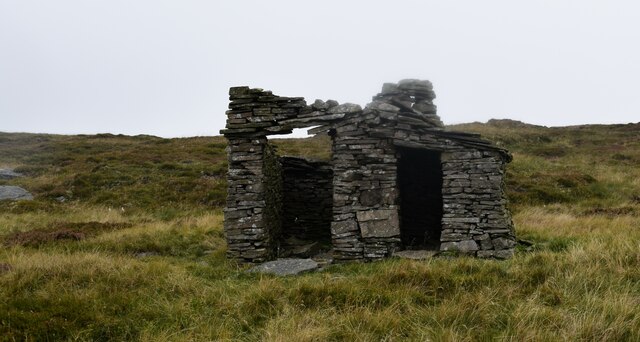
Historically, Langstrothdale was a center for lead mining, and remnants of this industry can still be seen today. The valley is also dotted with charming stone-built farmhouses and cottages, adding to its timeless appeal.

For those seeking a retreat from the hustle and bustle of modern life, Langstrothdale offers a peaceful escape. Its idyllic landscapes, rich history, and abundance of outdoor activities make it a perfect destination for nature lovers and those looking to immerse themselves in the beauty of Yorkshire's countryside.

If you have any feedback on the listing, please let us know in the comments section below.

Langstrothdale Images

Images are sourced within 2km of 54.209122/-2.1565524 or Grid Reference SD8979. Thanks to Geograph Open Source API. All images are credited.

Small building on Yockenthwaite Moor No idea what the building was used for.
Small building on Yockenthwaite Moor
No idea what the building was used for.
Yockenthwaite Farm and bridge The farm features in Channel 5's production of All Creatures Great and Small as Helen's family farm
Yockenthwaite Farm and bridge
The farm features in Channel 5's production of All Creatures Great and Small as Helen's family farm
Track above Yockenthwaite
Footpath in Rais Wood
Gate on the path above Strans Wood
Ancient trees above Strans Wood
Yokenthwaite Ford This ford in Langstrothdale is found close to Yockenthwaite.
Yokenthwaite Ford
This ford in Langstrothdale is found close to Yockenthwaite.
Langstrothdale View looking across the valley of the River Wharfe.
Langstrothdale
View looking across the valley of the River Wharfe.
Yockenthwaite
Yockenthwaite
River Wharfe The River Wharfe in Langstrothdale.
River Wharfe
The River Wharfe in Langstrothdale.
New House Barns above New House.
New House
Barns above New House.
Calf Barn See detailed picture of the date stone: <a href="https://www.geograph.org.uk/photo/7596135">SD8979 : Calf Barn</a>.
Calf Barn
See detailed picture of the date stone: SD8979 : Calf Barn.
Calf Barn Date stone at <a href="https://www.geograph.org.uk/photo/7596134">SD8979 : Calf Barn</a>.
Calf Barn
Date stone at SD8979 : Calf Barn.
Raisgill Start of the bridleway leading up to Horse Head Moor.
Raisgill
Start of the bridleway leading up to Horse Head Moor.
Horse Head At Horse Head looking towards Horse Head Gate.
Horse Head
At Horse Head looking towards Horse Head Gate.
Horse Head
Horse Head
Horse Head View from Horse Head, Whernside in the distance.
Horse Head
View from Horse Head, Whernside in the distance.
Horse Head Bridleway leading up to Horse Head.
Horse Head
Bridleway leading up to Horse Head.
Show me another place!

Langstrothdale is located at Grid Ref: SD8979 (Lat: 54.209122, Lng: -2.1565524)

Division: West Riding

Administrative County: North Yorkshire

District: Craven

Police Authority: North Yorkshire

What 3 Words

///basis.drank.trophy. Near Settle, North Yorkshire

Related Wikis

Deepdale, North Yorkshire

Deepdale is a hamlet in Langstrothdale in the Yorkshire Dales in the north of England. The hamlet is 6.5 miles (10.5 km) northwest of Kettlewell and 15...

Yockenthwaite

Yockenthwaite is a hamlet in the Craven district of North Yorkshire, England. It lies in the Langstrothdale valley in the Yorkshire Dales National Park...

Widdale

Widdale is a small side dale on the south side of Wensleydale in North Yorkshire, England. The dale lies to the east of Great Knoutberry Hill (also known...

Langstrothdale

Langstrothdale is a scenic valley in the Yorkshire Dales in North Yorkshire, England. The uppermost course of the River Wharfe runs through it, but Wharfedale...

Nearby Amenities

Located within 500m of 54.209122,-2.1565524
Hagg Gill
Natural: cave_entrance
Lat/Long: 54.2093357/-2.1624735
Langstroth Cave
Is In County: North Yorkshire
Is In Municipality: Craven
Is In Valley: Wharfedale
Natural: cave_entrance
Source: NPE
Lat/Long: 54.2065235/-2.1515023
Yockenthwaite Pot
Is In County: North Yorkshire
Is In Municipality: Craven
Is In Valley: Wharfedale
Natural: cave_entrance
Note: location approximate
Source: OS OpenData StreetView
Lat/Long: 54.212068/-2.1532063
Black Hole
Is In County: North Yorkshire
Is In Municipality: Craven
Is In Valley: Wharfedale
Natural: cave_entrance
Note: location approximate
Source: OS OpenData StreetView
Lat/Long: 54.2131346/-2.1563391
Barrier: stile
Stile: squeezer
Lat/Long: 54.2116424/-2.1597254
Ford: yes
Lat/Long: 54.2097648/-2.1556307
Jack's Cave
Natural: cave_entrance
Lat/Long: 54.2059274/-2.1604583
Natural: sinkhole
Lat/Long: 54.2110565/-2.1634135
Power: pole
Lat/Long: 54.2095833/-2.1498822
Power: pole
Lat/Long: 54.2099043/-2.1509137
Power: pole
Lat/Long: 54.2102836/-2.152124
Power: pole
Lat/Long: 54.2106256/-2.1532321
Power: pole
Lat/Long: 54.2109302/-2.1542254
Power: pole
Lat/Long: 54.2112617/-2.155285
Power: pole
Lat/Long: 54.2115946/-2.1563548
Power: pole
Lat/Long: 54.2119231/-2.1574119
Power: pole
Lat/Long: 54.2122561/-2.158515
Power: pole
Lat/Long: 54.2125965/-2.1595797
The data included in this document is from www.openstreetmap.org. The data is made available under ODbL.

Have you been to Langstrothdale?

Leave your review of Langstrothdale below (or comments, questions and feedback).