Clayton Vale

Valley in Lancashire

England

Clayton Vale

Rochdale Canal New housing development on Dob Brook Close alongside the Rochdale Canal.
Rochdale Canal Credit: Peter McDermott

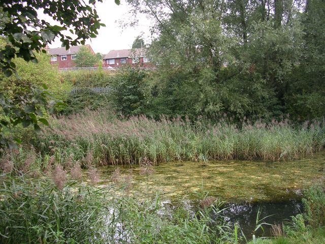
Clayton Vale is a picturesque valley located in the county of Lancashire, England. Situated in the eastern part of Manchester, this beautiful natural area is a popular destination for locals and tourists alike. Covering an area of approximately 50 hectares, Clayton Vale is a haven for nature enthusiasts and outdoor lovers.

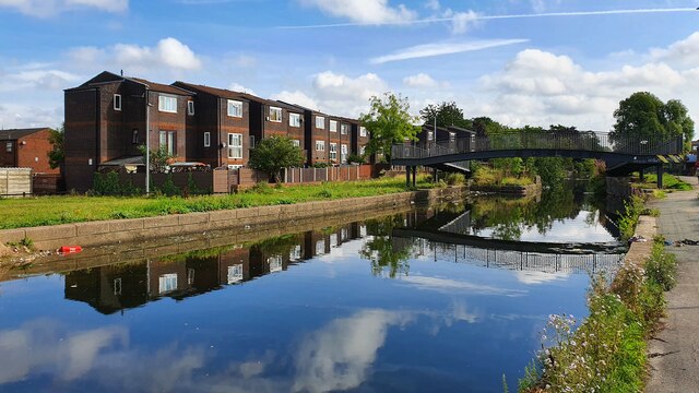
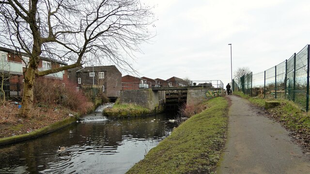
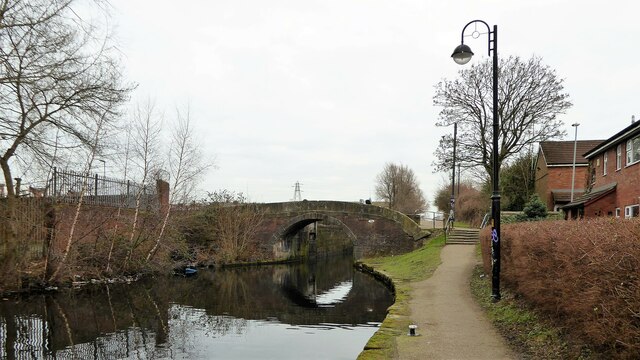
The valley is home to a diverse range of wildlife and boasts an abundance of flora and fauna. With its meandering river, lush green meadows, and dense woodlands, the valley offers a tranquil escape from the hustle and bustle of city life. Visitors can explore the numerous walking and cycling trails that wind their way through the valley, providing stunning views of the surrounding countryside.

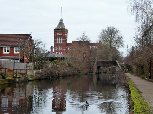
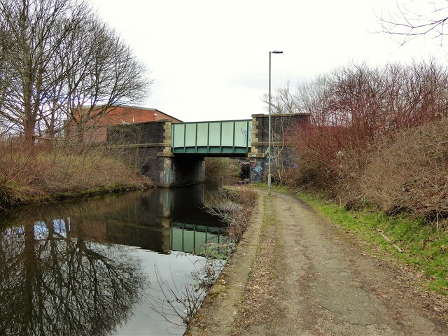
One of the highlights of Clayton Vale is the Manchester and Ashton Canal, which runs through the heart of the valley. This historic waterway provides a unique opportunity to experience the rich industrial heritage of the region. Visitors can enjoy a leisurely stroll along the canal towpath, taking in the picturesque scenery and admiring the beautifully restored locks and bridges.

Clayton Vale also offers a range of recreational facilities, including a BMX track and a mountain bike trail, making it a popular destination for adrenaline junkies and sports enthusiasts. Additionally, the valley is home to a number of picnic areas, perfect for enjoying a peaceful lunch amidst the stunning natural surroundings.

Overall, Clayton Vale is a hidden gem in Lancashire, offering a perfect blend of natural beauty, historical significance, and recreational activities. Whether you are seeking a peaceful retreat or an adventurous day out, this valley has something to offer for everyone.

If you have any feedback on the listing, please let us know in the comments section below.

Clayton Vale Images

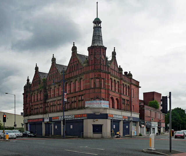
Images are sourced within 2km of 53.491279/-2.1752793 or Grid Reference SJ8899. Thanks to Geograph Open Source API. All images are credited.

Rochdale Canal New housing development on Dob Brook Close alongside the Rochdale Canal.
Rochdale Canal
New housing development on Dob Brook Close alongside the Rochdale Canal.
Direction Sign – Signpost on the A663 Broadway in Failsworth Located in Failsworth on the northwest side of the junction of the A663 Broadway with the A62 Oldham Road. 2 arms and annulus finial. See also <a title="https://www.geograph.org.uk/photo/2421808" href="https://www.geograph.org.uk/photo/2421808">Link</a>.

Milestone Society National ID: LA_SD8801B
Direction Sign – Signpost on the A663 Broadway in Failsworth
Located in Failsworth on the northwest side of the junction of the A663 Broadway with the A62 Oldham Road. 2 arms and annulus finial. See also Link. Milestone Society National ID: LA_SD8801B
Rochdale Canal
Rochdale Canal
Rochdale Canal New houses alongside the Rochdale Canal.  See also <a href="https://www.geograph.org.uk/photo/6959893">SD8800 : Rochdale Canal</a>.
Rochdale Canal
New houses alongside the Rochdale Canal. See also SD8800 : Rochdale Canal.
Restored lock No.70 Pinfold lock on the Rochdale Canal at Newton Heath
Restored lock No.70
Pinfold lock on the Rochdale Canal at Newton Heath
New canal side housing By the Rochdale Canal at Newton Heath
New canal side housing
By the Rochdale Canal at Newton Heath
Tannersfield Canal Footbridge On the Rochdale Canal, this is bridge No.79A
Tannersfield Canal Footbridge
On the Rochdale Canal, this is bridge No.79A
Back Lane Bridge This is bridge No.79 on the Rochdale Canal. Regent Mill towers over the scene, a trick of the perspective.
Back Lane Bridge
This is bridge No.79 on the Rochdale Canal. Regent Mill towers over the scene, a trick of the perspective.
Ten Acres Lane Bridge No.83 Over the Rochdale Canal at Newton Heath
Ten Acres Lane Bridge No.83
Over the Rochdale Canal at Newton Heath
Approach to Central Park Metrolink Station Along the very broad pedestrian access of The Gateway
Approach to Central Park Metrolink Station
Along the very broad pedestrian access of The Gateway
Moston Brook Weir An old weir for the demolished Moston Mill. The footbridge leads on to a path that follows the old mill race to the mill but is now totally overgrown with brambles. Elsewhere in the valley new all weather path surfaces have been laid so hopefully this path can be cleared and reopened.
Moston Brook Weir
An old weir for the demolished Moston Mill. The footbridge leads on to a path that follows the old mill race to the mill but is now totally overgrown with brambles. Elsewhere in the valley new all weather path surfaces have been laid so hopefully this path can be cleared and reopened.
Railway Bridge over St Mary's Road View on the road leaving Newton Heath
Railway Bridge over St Mary's Road
View on the road leaving Newton Heath
Former pub, Oldham Road, Manchester (1) Once the Weavers Arms, a Vaux pub with glazed tile front.
It has been closed since at least 2011 (<a href="https://www.geograph.org.uk/photo/2248107">SD8801 : The Weavers Arms</a>) and now mainly acts as an advertising hoarding for the Manchester Tile Centre.
Former pub, Oldham Road, Manchester (1)
Once the Weavers Arms, a Vaux pub with glazed tile front. It has been closed since at least 2011 (SD8801 : The Weavers Arms) and now mainly acts as an advertising hoarding for the Manchester Tile Centre.
Former pub, Oldham Road, Manchester (2) Another former Vaux pub that has been closed since at least 2011. Same house design as its similarly beleaguered compatriot a little further along the street (<a href="https://www.geograph.org.uk/photo/7611263">SD8801 : Former pub, Oldham Road, Manchester (1)</a>).
Former pub, Oldham Road, Manchester (2)
Another former Vaux pub that has been closed since at least 2011. Same house design as its similarly beleaguered compatriot a little further along the street (SD8801 : Former pub, Oldham Road, Manchester (1)).
Rosedale Building, Oldham Road, Manchester Lording it over its corner site even when largely derelict. It was built for the Co-operative Society.
Another bit of history has bitten the dust - it was demolished c2020.
Rosedale Building, Oldham Road, Manchester
Lording it over its corner site even when largely derelict. It was built for the Co-operative Society. Another bit of history has bitten the dust - it was demolished c2020.
1051 Oldham Road, Manchester No doubting the original purpose of this building.
In 2016 it was still a bank, a branch of the Royal Bank of Scotland, but not long afterwards it became part of the exodus of high street banks from the high street.
1051 Oldham Road, Manchester
No doubting the original purpose of this building. In 2016 it was still a bank, a branch of the Royal Bank of Scotland, but not long afterwards it became part of the exodus of high street banks from the high street.
Coal train heads through Dean Lane Station Stanier 8F 48665 heads east through what was then Dean Lane station on the 'Oldham Loop' line with a coal train; it is assisted in the rear by Black 5 45200. Since 2012 this is now the single-platform Metrolink  Newton Heath and Moston Tram Stop, see: <a href="https://www.geograph.org.uk/photo/5250666">SD8700 : Newton Heath and  Moston tram stop</a>. The second line remains in use for goods trains. My photo is framed by the since-demolished footbridge.
Coal train heads through Dean Lane Station
Stanier 8F 48665 heads east through what was then Dean Lane station on the 'Oldham Loop' line with a coal train; it is assisted in the rear by Black 5 45200. Since 2012 this is now the single-platform Metrolink Newton Heath and Moston Tram Stop, see: SD8700 : Newton Heath and Moston tram stop. The second line remains in use for goods trains. My photo is framed by the since-demolished footbridge.
Newton Heath Shed Opened by the Lancashire & Yorkshire Railway in 1876 Newton Heath became the Company's largest shed with an allocation of 232 in 1922. Closure to steam came on 1st July 1968, so less than 3 weeks to go here, and 8 weeks before the end of steam traction on BR; it was one of the last 6 steam sheds. Just visible is Stanier Black 5 44890, alongside it is already withdrawn BR Standard 9F 92054. The site is now occupied by Newton Heath Train Maintenance Depot.
Newton Heath Shed
Opened by the Lancashire & Yorkshire Railway in 1876 Newton Heath became the Company's largest shed with an allocation of 232 in 1922. Closure to steam came on 1st July 1968, so less than 3 weeks to go here, and 8 weeks before the end of steam traction on BR; it was one of the last 6 steam sheds. Just visible is Stanier Black 5 44890, alongside it is already withdrawn BR Standard 9F 92054. The site is now occupied by Newton Heath Train Maintenance Depot.
Show me another place!

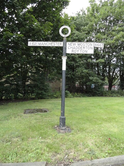
Clayton Vale is located at Grid Ref: SJ8899 (Lat: 53.491279, Lng: -2.1752793)

Unitary Authority: Manchester

Police Authority: Greater Manchester

What 3 Words

///third.hood.wings. Near Failsworth, Manchester

Related Wikis

Clayton Vale

Clayton Vale is an area of green space in Clayton, Manchester, England, through which the River Medlock flows. Redeveloped in 1986, the land has a rich...

Clayton Bridge railway station

Clayton Bridge railway station, Manchester, was a railway station that served the locality between 1846 and 1968. == Construction, opening and ownership... ==

Clayton, Manchester

Clayton is a suburb of Manchester, England, three miles east of the city centre on Ashton New Road. Historically in Lancashire, Clayton takes its name...

Clayton and Openshaw (ward)

Clayton and Openshaw is an area and electoral ward of Manchester, England created by the Local Government Boundary Commission for England (LGBCE) replacing...

Nearby Amenities

Located within 500m of 53.491279,-2.1752793
Turning Circle
Goldenhill Avenue
Lat/Long: 53.4884612/-2.1788206
Turning Circle
Lat/Long: 53.4873159/-2.1760084
Turning Circle
Lat/Long: 53.4871404/-2.1749411
Turning Circle
Lat/Long: 53.4869723/-2.1774278
Turning Circle
Lat/Long: 53.4883932/-2.1767236
Turning Circle
Lat/Long: 53.4879719/-2.1757044
Turning Circle
Lat/Long: 53.4877827/-2.174656
Bench
Lat/Long: 53.4916743/-2.1678057
Tourism: picnic_site
Lat/Long: 53.4920869/-2.1682959
Bench
Lat/Long: 53.4913838/-2.1686089
Bench
Lat/Long: 53.4911431/-2.1693725
Bench
Lat/Long: 53.4910435/-2.1705165
Bench
Lat/Long: 53.4910374/-2.1735954
Bench
Lat/Long: 53.491091/-2.1761261
Bench
Lat/Long: 53.4913539/-2.1773099
Tourism: picnic_site
Lat/Long: 53.4918435/-2.178025
Bench
Lat/Long: 53.4914602/-2.178912
Bench
Lat/Long: 53.4916091/-2.1825204
Bus Stop
Newton Heath, Scotland Hall Road / near Amos Avenue
Bus: yes
Naptan AtcoCode: 1800EB35091
Naptan Bearing: SE
Naptan CommonName: Scotland Hall Road/Amos Avenue
Naptan Indicator: House 65
Naptan Landmark: HOUSE 61
Naptan NaptanCode: manajgwg
Naptan PlusbusZoneRef: MNCRPIC
Naptan ShortCommonName: Amos Avenue
Naptan Street: SCOTLAND HALL R
Naptan Verified: no
Network: TfGM
Operator: TfGM
Public Transport: platform
Source: naptan_import
Lat/Long: 53.4943036/-2.1807769
Bus Stop
Newton Heath, Scotland Hall Road / opposite Amos Avenue
Bus: yes
Naptan AtcoCode: 1800EB35101
Naptan Bearing: NW
Naptan CommonName: Scotland Hall Road/Amos Avenue
Naptan Indicator: House 72
Naptan Landmark: HOUSE 72
Naptan NaptanCode: manajgwj
Naptan PlusbusZoneRef: MNCRPIC
Naptan ShortCommonName: Amos Avenue
Naptan Street: SCOTLAND HALL R
Naptan Verified: no
Network: TfGM
Operator: TfGM
Public Transport: platform
Source: naptan_import
Lat/Long: 53.4939533/-2.1806096
Bus Stop
Newton Heath, Amos Avenue / opposite Ramsgate Road
Bus: yes
Naptan AtcoCode: 1800EB35111
Naptan Bearing: W
Naptan CommonName: Amos Avenue/Ramsgate Road
Naptan Indicator: House 24
Naptan Landmark: HOUSE 22
Naptan NaptanCode: manajgwm
Naptan PlusbusZoneRef: MNCRPIC
Naptan ShortCommonName: Ramsgate Road
Naptan Street: AMOS AVENUE
Naptan Verified: no
Network: TfGM
Operator: TfGM
Public Transport: platform
Source: naptan_import
Lat/Long: 53.4940189/-2.1788161
Bus Stop
Newton Heath, Amos Avenue / near Ramsgate Road
Bus: yes
Naptan AtcoCode: 1800EB35121
Naptan Bearing: E
Naptan CommonName: Amos Avenue/Ramsgate Road
Naptan Indicator: House 19
Naptan Landmark: HOUSE 19
Naptan NaptanCode: manajgwp
Naptan PlusbusZoneRef: MNCRPIC
Naptan ShortCommonName: Ramsgate Road
Naptan Street: AMOS AVENUE
Naptan Verified: no
Network: TfGM
Operator: TfGM
Public Transport: platform
Source: naptan_import
Lat/Long: 53.4942988/-2.1779581
Bus Stop
Newton Heath, Amos Avenue / near Culcheth Lane
Bus: yes
Naptan AtcoCode: 1800EB35131
Naptan Bearing: W
Naptan CommonName: Amos Avenue/Culcheth Lane
Naptan Indicator: Opp House 57
Naptan Landmark: CHURCH
Naptan NaptanCode: manajgwt
Naptan PlusbusZoneRef: MNCRPIC
Naptan ShortCommonName: Culcheth Lane
Naptan Street: AMOS AVENUE
Naptan Verified: no
Network: TfGM
Operator: TfGM
Public Transport: platform
Source: naptan_import
Lat/Long: 53.4948049/-2.1761212
Bus Stop
Newton Heath, Amos Avenue / adjacent Culcheth Lane
Bus: yes
Naptan AtcoCode: 1800EB35141
Naptan Bearing: E
Naptan CommonName: Amos Avenue/Culcheth Lane
Naptan Indicator: House 81
Naptan Landmark: HOUSE 81
Naptan NaptanCode: manajmad
Naptan PlusbusZoneRef: MNCRPIC
Naptan ShortCommonName: Culcheth Lane
Naptan Street: AMOS AVENUE
Naptan Verified: no
Network: TfGM
Operator: TfGM
Public Transport: platform
Source: naptan_import
Lat/Long: 53.4951476/-2.1753689
Turning Circle
Lat/Long: 53.4878679/-2.1715929
Barrier: bollard
Bicycle: yes
Foot: yes
Horse: yes
Motor Vehicle: no
Lat/Long: 53.4928934/-2.1730916
Power: tower
Lat/Long: 53.4899438/-2.1822427
Power: tower
Lat/Long: 53.4891917/-2.1732148
Power: tower
Lat/Long: 53.4897515/-2.1772665
Power: tower
Lat/Long: 53.4894905/-2.1774629
Power: tower
Lat/Long: 53.4894523/-2.1728389
Power: tower
Lat/Long: 53.4897108/-2.18213
Elder
Lat/Long: 53.488901/-2.1775729
Generator Method: photovoltaic
Generator Output Electricity: yes
Generator Source: solar
Generator Type: solar_photovoltaic_panel
Location: roof
Power: generator
Lat/Long: 53.4939379/-2.17409
Generator Method: photovoltaic
Generator Output Electricity: yes
Generator Source: solar
Generator Type: solar_photovoltaic_panel
Location: roof
Power: generator
Lat/Long: 53.4939563/-2.173972
Generator Method: photovoltaic
Generator Output Electricity: yes
Generator Source: solar
Generator Type: solar_photovoltaic_panel
Location: roof
Power: generator
Lat/Long: 53.4936563/-2.1739103
Generator Method: photovoltaic
Generator Output Electricity: yes
Generator Source: solar
Generator Type: solar_photovoltaic_panel
Location: roof
Power: generator
Lat/Long: 53.4936866/-2.1737896
Generator Method: photovoltaic
Generator Output Electricity: yes
Generator Source: solar
Generator Type: solar_photovoltaic_panel
Location: roof
Power: generator
Lat/Long: 53.4936834/-2.1736783
Generator Method: photovoltaic
Generator Output Electricity: yes
Generator Source: solar
Generator Type: solar_photovoltaic_panel
Location: roof
Power: generator
Lat/Long: 53.4937592/-2.1732532
Generator Method: photovoltaic
Generator Output Electricity: yes
Generator Source: solar
Generator Type: solar_photovoltaic_panel
Location: roof
Power: generator
Lat/Long: 53.4937377/-2.1731485
Generator Method: photovoltaic
Generator Output Electricity: yes
Generator Source: solar
Generator Type: solar_photovoltaic_panel
Location: roof
Power: generator
Lat/Long: 53.4938111/-2.1723989
Generator Method: photovoltaic
Generator Output Electricity: yes
Generator Source: solar
Generator Type: solar_photovoltaic_panel
Location: roof
Power: generator
Lat/Long: 53.4938087/-2.1720529
Generator Method: photovoltaic
Generator Output Electricity: yes
Generator Source: solar
Generator Type: solar_photovoltaic_panel
Location: roof
Power: generator
Lat/Long: 53.4954051/-2.1725383
Generator Method: photovoltaic
Generator Output Electricity: yes
Generator Source: solar
Generator Type: solar_photovoltaic_panel
Location: roof
Power: generator
Lat/Long: 53.4954004/-2.1726456
Generator Method: photovoltaic
Generator Output Electricity: yes
Generator Source: solar
Generator Type: solar_photovoltaic_panel
Location: roof
Power: generator
Lat/Long: 53.4954004/-2.1727395
Generator Method: photovoltaic
Generator Output Electricity: yes
Generator Source: solar
Generator Type: solar_photovoltaic_panel
Location: roof
Power: generator
Lat/Long: 53.4953956/-2.17282
Generator Method: photovoltaic
Generator Output Electricity: yes
Generator Source: solar
Generator Type: solar_photovoltaic_panel
Location: roof
Power: generator
Lat/Long: 53.4950637/-2.1728012
Generator Method: photovoltaic
Generator Output Electricity: yes
Generator Source: solar
Generator Type: solar_photovoltaic_panel
Location: roof
Power: generator
Lat/Long: 53.4950541/-2.1729085
Generator Method: photovoltaic
Generator Output Electricity: yes
Generator Source: solar
Generator Type: solar_photovoltaic_panel
Location: roof
Power: generator
Lat/Long: 53.4950461/-2.1730185
Generator Method: photovoltaic
Generator Output Electricity: yes
Generator Source: solar
Generator Type: solar_photovoltaic_panel
Location: roof
Power: generator
Lat/Long: 53.495027/-2.1732786
Generator Method: photovoltaic
Generator Output Electricity: yes
Generator Source: solar
Generator Type: solar_photovoltaic_panel
Location: roof
Power: generator
Lat/Long: 53.4950174/-2.1733859
Generator Method: photovoltaic
Generator Output Electricity: yes
Generator Source: solar
Generator Type: solar_photovoltaic_panel
Location: roof
Power: generator
Lat/Long: 53.4950078/-2.1734744
Generator Method: photovoltaic
Generator Output Electricity: yes
Generator Source: solar
Generator Type: solar_photovoltaic_panel
Location: roof
Power: generator
Lat/Long: 53.4947081/-2.1726593
Generator Method: photovoltaic
Generator Output Electricity: yes
Generator Source: solar
Generator Type: solar_photovoltaic_panel
Location: roof
Power: generator
Lat/Long: 53.4947009/-2.1727474
Generator Method: photovoltaic
Generator Output Electricity: yes
Generator Source: solar
Generator Type: solar_photovoltaic_panel
Location: roof
Power: generator
Lat/Long: 53.4946929/-2.1728445
Generator Method: photovoltaic
Generator Output Electricity: yes
Generator Source: solar
Generator Type: solar_photovoltaic_panel
Location: roof
Power: generator
Lat/Long: 53.4946848/-2.1729445
Generator Method: photovoltaic
Generator Output Electricity: yes
Generator Source: solar
Generator Type: solar_photovoltaic_panel
Location: roof
Power: generator
Lat/Long: 53.4946781/-2.1730259
Generator Method: photovoltaic
Generator Output Electricity: yes
Generator Source: solar
Generator Type: solar_photovoltaic_panel
Location: roof
Power: generator
Lat/Long: 53.4946666/-2.1731676
Generator Method: photovoltaic
Generator Output Electricity: yes
Generator Source: solar
Generator Type: solar_photovoltaic_panel
Location: roof
Power: generator
Lat/Long: 53.4956429/-2.1756175
Generator Method: photovoltaic
Generator Output Electricity: yes
Generator Source: solar
Generator Type: solar_photovoltaic_panel
Location: roof
Power: generator
Lat/Long: 53.4956652/-2.1755317
Generator Method: photovoltaic
Generator Output Electricity: yes
Generator Source: solar
Generator Type: solar_photovoltaic_panel
Location: roof
Power: generator
Lat/Long: 53.4945499/-2.18007
Crossing
Lat/Long: 53.4874644/-2.1735798
The data included in this document is from www.openstreetmap.org. The data is made available under ODbL.

Have you been to Clayton Vale?

Leave your review of Clayton Vale below (or comments, questions and feedback).