Green Cleugh

Valley in Durham

England

Green Cleugh

Upper groove of South Grain South Grain is a stream developing on the northern slope of Burtree Fell and flowing down into the head of Rook Hope and so to Rookhope Burn, the valley of which can be discerned in the distance.
Upper groove of South Grain Credit: Trevor Littlewood

Green Cleugh is a picturesque valley located in County Durham, England. Nestled in the North Pennines Area of Outstanding Natural Beauty, it offers breathtaking views and a peaceful atmosphere for visitors to enjoy. The valley is situated near the village of Blanchland and is easily accessible via the B6306 road.

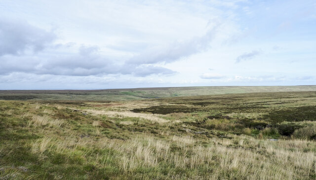
Green Cleugh is known for its scenic beauty, with rolling hills, lush meadows, and dense woodlands. The valley is crisscrossed by a network of footpaths and trails, making it a popular destination for hikers and nature enthusiasts. The River Derwent flows through the valley, adding to its charm and providing opportunities for fishing and wildlife spotting.

The area is rich in flora and fauna, with a diverse range of plant species, including heather, bracken, and bluebells. The valley is home to various bird species, such as red grouse, curlews, and peregrine falcons, making it a haven for birdwatchers. Additionally, the valley is inhabited by several mammals, including otters, badgers, and foxes.

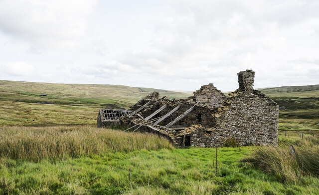
Green Cleugh has a rich history, with evidence of human settlements dating back to the Bronze Age. The valley was once a thriving mining area, with lead and coal mines operating in the 19th and early 20th centuries. Remnants of these industrial activities can still be seen in the form of old mine entrances and ruins.

Overall, Green Cleugh offers a tranquil escape from urban life, allowing visitors to immerse themselves in the natural beauty and rich history of the area. Whether it's a leisurely stroll, a challenging hike, or simply a moment of peace amidst nature, Green Cleugh has something to offer for everyone.

If you have any feedback on the listing, please let us know in the comments section below.

Green Cleugh Images

Images are sourced within 2km of 54.791799/-2.1810849 or Grid Reference NY8844. Thanks to Geograph Open Source API. All images are credited.

Upper groove of South Grain South Grain is a stream developing on the northern slope of Burtree Fell and flowing down into the head of Rook Hope and so to Rookhope Burn, the valley of which can be discerned in the distance.
Upper groove of South Grain
South Grain is a stream developing on the northern slope of Burtree Fell and flowing down into the head of Rook Hope and so to Rookhope Burn, the valley of which can be discerned in the distance.
Ruins of  Rookhope Head The building at Rookhope Head stands on desolate moorland at the head of Rook Hope; it has been deserted at least for many decades. An image from 2013 - <a title="https://www.geograph.org.uk/photo/3489056" href="https://www.geograph.org.uk/photo/3489056">Link</a> - shows some of the main roof timbers and stones in place: all collapsed now. The wooden electricity supply poles have also been removed.
Ruins of Rookhope Head
The building at Rookhope Head stands on desolate moorland at the head of Rook Hope; it has been deserted at least for many decades. An image from 2013 - Link - shows some of the main roof timbers and stones in place: all collapsed now. The wooden electricity supply poles have also been removed.
Groverake Mine The Lodging Shop and Stables buildings are on the right.
Groverake Mine
The Lodging Shop and Stables buildings are on the right.
Groverake Mine See here for close-up view of the information board: <a href="https://www.geograph.org.uk/photo/7310523">NY8944 : Information board, Groverake Mine</a>
Groverake Mine
See here for close-up view of the information board: NY8944 : Information board, Groverake Mine
Information board, Groverake Mine Groverake or Grove Rake. Shown on old maps as Groove Rake; probably from the nearby stream, Groove Rake Sike, or the heavily mined area of moorland of the same name where the stream rises. The lead miners’ term 'rake' applies to a major vertical or near-vertical mineralised vein.

Grove Rake is the site of a 19th century lead mine, though it was mined for fluorspar in the 20th century. At least six shafts and many ore hushes have been destroyed by later quarrying The site was worked from 1760 to 1985.
Keys to the Past (D4835): <span class="nowrap"><a title="https://keystothepast.info/search-records/results-of-search/results-of-search-2/Site-Details/?PRN=D4835" rel="nofollow ugc noopener" href="https://keystothepast.info/search-records/results-of-search/results-of-search-2/Site-Details/?PRN=D4835">Link</a><img style="margin-left:2px;" alt="External link" title="External link - shift click to open in new window" src="https://s1.geograph.org.uk/img/external.png" width="10" height="10"/></span>
Information board, Groverake Mine
Groverake or Grove Rake. Shown on old maps as Groove Rake; probably from the nearby stream, Groove Rake Sike, or the heavily mined area of moorland of the same name where the stream rises. The lead miners’ term 'rake' applies to a major vertical or near-vertical mineralised vein. Grove Rake is the site of a 19th century lead mine, though it was mined for fluorspar in the 20th century. At least six shafts and many ore hushes have been destroyed by later quarrying The site was worked from 1760 to 1985. Keys to the Past (D4835): LinkExternal link
Pony Stables & Firestone Mine Incline, Groverake Groverake or Grove Rake. Shown on old maps as Groove Rake; probably from the nearby stream, Groove Rake Sike, or the heavily mined area of moorland of the same name where the stream rises. The lead miners’ term 'rake' applies to a major vertical or near-vertical mineralised vein.

Grove Rake is the site of a 19th century lead mine, though it was mined for fluorspar in the 20th century. At least six shafts and many ore hushes have been destroyed by later quarrying The site was worked from 1760 to 1985.
Keys to the Past (D4835): <span class="nowrap"><a title="https://keystothepast.info/search-records/results-of-search/results-of-search-2/Site-Details/?PRN=D4835" rel="nofollow ugc noopener" href="https://keystothepast.info/search-records/results-of-search/results-of-search-2/Site-Details/?PRN=D4835">Link</a><img style="margin-left:2px;" alt="External link" title="External link - shift click to open in new window" src="https://s1.geograph.org.uk/img/external.png" width="10" height="10"/></span>
Pony Stables & Firestone Mine Incline, Groverake
Groverake or Grove Rake. Shown on old maps as Groove Rake; probably from the nearby stream, Groove Rake Sike, or the heavily mined area of moorland of the same name where the stream rises. The lead miners’ term 'rake' applies to a major vertical or near-vertical mineralised vein. Grove Rake is the site of a 19th century lead mine, though it was mined for fluorspar in the 20th century. At least six shafts and many ore hushes have been destroyed by later quarrying The site was worked from 1760 to 1985. Keys to the Past (D4835): LinkExternal link
Groverake Mine Groverake or Grove Rake. Shown on old maps as Groove Rake; probably from the nearby stream, Groove Rake Sike, or the heavily mined area of moorland of the same name where the stream rises. The lead miners’ term 'rake' applies to a major vertical or near-vertical mineralised vein.

Grove Rake is the site of a 19th century lead mine, though it was mined for fluorspar in the 20th century. At least six shafts and many ore hushes have been destroyed by later quarrying The site was worked from 1760 to 1985.
Keys to the Past (D4835): <span class="nowrap"><a title="https://keystothepast.info/search-records/results-of-search/results-of-search-2/Site-Details/?PRN=D4835" rel="nofollow ugc noopener" href="https://keystothepast.info/search-records/results-of-search/results-of-search-2/Site-Details/?PRN=D4835">Link</a><img style="margin-left:2px;" alt="External link" title="External link - shift click to open in new window" src="https://s1.geograph.org.uk/img/external.png" width="10" height="10"/></span>
Groverake Mine
Groverake or Grove Rake. Shown on old maps as Groove Rake; probably from the nearby stream, Groove Rake Sike, or the heavily mined area of moorland of the same name where the stream rises. The lead miners’ term 'rake' applies to a major vertical or near-vertical mineralised vein. Grove Rake is the site of a 19th century lead mine, though it was mined for fluorspar in the 20th century. At least six shafts and many ore hushes have been destroyed by later quarrying The site was worked from 1760 to 1985. Keys to the Past (D4835): LinkExternal link
Buildings south of Groverake Mine Groverake or Grove Rake. Shown on old maps as Groove Rake; probably from the nearby stream, Groove Rake Sike, or the heavily mined area of moorland of the same name where the stream rises. The lead miners’ term 'rake' applies to a major vertical or near-vertical mineralised vein.

Grove Rake is the site of a 19th century lead mine, though it was mined for fluorspar in the 20th century. At least six shafts and many ore hushes have been destroyed by later quarrying The site was worked from 1760 to 1985.
Keys to the Past (D4835): <span class="nowrap"><a title="https://keystothepast.info/search-records/results-of-search/results-of-search-2/Site-Details/?PRN=D4835" rel="nofollow ugc noopener" href="https://keystothepast.info/search-records/results-of-search/results-of-search-2/Site-Details/?PRN=D4835">Link</a><img style="margin-left:2px;" alt="External link" title="External link - shift click to open in new window" src="https://s1.geograph.org.uk/img/external.png" width="10" height="10"/></span>
Buildings south of Groverake Mine
Groverake or Grove Rake. Shown on old maps as Groove Rake; probably from the nearby stream, Groove Rake Sike, or the heavily mined area of moorland of the same name where the stream rises. The lead miners’ term 'rake' applies to a major vertical or near-vertical mineralised vein. Grove Rake is the site of a 19th century lead mine, though it was mined for fluorspar in the 20th century. At least six shafts and many ore hushes have been destroyed by later quarrying The site was worked from 1760 to 1985. Keys to the Past (D4835): LinkExternal link
Former Lodging Shop, Groverake Mine Groverake or Grove Rake. Shown on old maps as Groove Rake; probably from the nearby stream, Groove Rake Sike, or the heavily mined area of moorland of the same name where the stream rises. The lead miners’ term 'rake' applies to a major vertical or near-vertical mineralised vein.

Grove Rake is the site of a 19th century lead mine, though it was mined for fluorspar in the 20th century. At least six shafts and many ore hushes have been destroyed by later quarrying The site was worked from 1760 to 1985.
Keys to the Past (D4835): <span class="nowrap"><a title="https://keystothepast.info/search-records/results-of-search/results-of-search-2/Site-Details/?PRN=D4835" rel="nofollow ugc noopener" href="https://keystothepast.info/search-records/results-of-search/results-of-search-2/Site-Details/?PRN=D4835">Link</a><img style="margin-left:2px;" alt="External link" title="External link - shift click to open in new window" src="https://s1.geograph.org.uk/img/external.png" width="10" height="10"/></span>
Former Lodging Shop, Groverake Mine
Groverake or Grove Rake. Shown on old maps as Groove Rake; probably from the nearby stream, Groove Rake Sike, or the heavily mined area of moorland of the same name where the stream rises. The lead miners’ term 'rake' applies to a major vertical or near-vertical mineralised vein. Grove Rake is the site of a 19th century lead mine, though it was mined for fluorspar in the 20th century. At least six shafts and many ore hushes have been destroyed by later quarrying The site was worked from 1760 to 1985. Keys to the Past (D4835): LinkExternal link
Rookhope Burn below Groverake Mine Groverake or Grove Rake. Shown on old maps as Groove Rake; probably from the nearby stream, Groove Rake Sike, or the heavily mined area of moorland of the same name where the stream rises. The lead miners’ term 'rake' applies to a major vertical or near-vertical mineralised vein.

Grove Rake is the site of a 19th century lead mine, though it was mined for fluorspar in the 20th century. At least six shafts and many ore hushes have been destroyed by later quarrying The site was worked from 1760 to 1985.
Keys to the Past (D4835): <span class="nowrap"><a title="https://keystothepast.info/search-records/results-of-search/results-of-search-2/Site-Details/?PRN=D4835" rel="nofollow ugc noopener" href="https://keystothepast.info/search-records/results-of-search/results-of-search-2/Site-Details/?PRN=D4835">Link</a><img style="margin-left:2px;" alt="External link" title="External link - shift click to open in new window" src="https://s1.geograph.org.uk/img/external.png" width="10" height="10"/></span>
Rookhope Burn below Groverake Mine
Groverake or Grove Rake. Shown on old maps as Groove Rake; probably from the nearby stream, Groove Rake Sike, or the heavily mined area of moorland of the same name where the stream rises. The lead miners’ term 'rake' applies to a major vertical or near-vertical mineralised vein. Grove Rake is the site of a 19th century lead mine, though it was mined for fluorspar in the 20th century. At least six shafts and many ore hushes have been destroyed by later quarrying The site was worked from 1760 to 1985. Keys to the Past (D4835): LinkExternal link
Mine level, Groverake Showing datestone of 1878 to right of portal <a href="https://www.geograph.org.uk/photo/1230817">NY8944 : Plaque at the mine level entrance, Grove Rake</a>.
Mine level, Groverake
Showing datestone of 1878 to right of portal NY8944 : Plaque at the mine level entrance, Grove Rake.
Headgear of 80 fathom shaft, Groverake Groverake or Grove Rake. Shown on old maps as Groove Rake; probably from the nearby stream, Groove Rake Sike, or the heavily mined area of moorland of the same name where the stream rises. The lead miners’ term 'rake' applies to a major vertical or near-vertical mineralised vein.

Grove Rake is the site of a 19th century lead mine, though it was mined for fluorspar in the 20th century. At least six shafts and many ore hushes have been destroyed by later quarrying The site was worked from 1760 to 1985.
Keys to the Past (D4835): <span class="nowrap"><a title="https://keystothepast.info/search-records/results-of-search/results-of-search-2/Site-Details/?PRN=D4835" rel="nofollow ugc noopener" href="https://keystothepast.info/search-records/results-of-search/results-of-search-2/Site-Details/?PRN=D4835">Link</a><img style="margin-left:2px;" alt="External link" title="External link - shift click to open in new window" src="https://s1.geograph.org.uk/img/external.png" width="10" height="10"/></span>
Headgear of 80 fathom shaft, Groverake
Groverake or Grove Rake. Shown on old maps as Groove Rake; probably from the nearby stream, Groove Rake Sike, or the heavily mined area of moorland of the same name where the stream rises. The lead miners’ term 'rake' applies to a major vertical or near-vertical mineralised vein. Grove Rake is the site of a 19th century lead mine, though it was mined for fluorspar in the 20th century. At least six shafts and many ore hushes have been destroyed by later quarrying The site was worked from 1760 to 1985. Keys to the Past (D4835): LinkExternal link
Frazer's Quarry, Rookhopeburn Head This large quarry was mined for ironstone. It is now overgrown and covered in mounds of rubble. The ore was taken by railway to iron smelting sites at Tow Law. The quarry was shut in the 1870s due to a collapse in the iron trade.
<span class="nowrap"><a title="https://keystothepast.info/search-records/results-of-search/results-of-search-2/Site-Details/?PRN=D4802" rel="nofollow ugc noopener" href="https://keystothepast.info/search-records/results-of-search/results-of-search-2/Site-Details/?PRN=D4802">Link</a><img style="margin-left:2px;" alt="External link" title="External link - shift click to open in new window" src="https://s1.geograph.org.uk/img/external.png" width="10" height="10"/></span>
Frazer's Quarry, Rookhopeburn Head
This large quarry was mined for ironstone. It is now overgrown and covered in mounds of rubble. The ore was taken by railway to iron smelting sites at Tow Law. The quarry was shut in the 1870s due to a collapse in the iron trade. LinkExternal link
Road in Rookhope Valley
Wolf Cleugh (2) See <a href="https://www.geograph.org.uk/photo/1230639">NY9043 : Wolf Cleugh</a>.
Wolf Cleugh (2)
Wolf Cleugh and Rookhope Burn See <a href="https://www.geograph.org.uk/photo/1230639">NY9043 : Wolf Cleugh</a>.
Wolf Cleugh and Rookhope Burn
Wolf Cleugh and Rookhope Burn (2) See <a href="https://www.geograph.org.uk/photo/1230639">NY9043 : Wolf Cleugh</a>.
Wolf Cleugh and Rookhope Burn (2)
Show me another place!

Green Cleugh is located at Grid Ref: NY8844 (Lat: 54.791799, Lng: -2.1810849)

Unitary Authority: County Durham

Police Authority: Durham

What 3 Words

///hurtles.depth.writings. Near Stanhope, Co. Durham

Nearby Locations

Green Cleugh Rook Hope

Related Wikis

Allenheads

Allenheads is a former mining village in the Pennines to the north of Weardale in Northumberland, England. Lead extraction was the settlement's industry...

Lintzgarth

Lintzgarth is a village in the civil parish of Stanhope, in County Durham, England. It is situated to the west of Rookhope. The Lintzgarth smeltmill was...

Lanehead

Lanehead is a hamlet in the civil parish of Stanhope, in County Durham, England. It lies at the head of Weardale, approximately 2 km west of Cowshill....

Cornriggs Meadows

Cornriggs Meadows is a Site of Special Scientific Interest in Upper Weardale in north-west County Durham, England. It consists of a group of fields, located...

Nearby Amenities

Located within 500m of 54.791799,-2.1810849
Turning Circle
Lat/Long: 54.7911846/-2.1818107
Hunting Stand
Hunting Stand: grouse_butt
Lat/Long: 54.7877421/-2.1828729
Hunting Stand
Hunting Stand: grouse_butt
Lat/Long: 54.7882014/-2.1825269
Hunting Stand
Hunting Stand: grouse_butt
Lat/Long: 54.7885416/-2.1822774
Hunting Stand
Hunting Stand: grouse_butt
Lat/Long: 54.7889917/-2.1819341
Hunting Stand
Hunting Stand: grouse_butt
Lat/Long: 54.7894386/-2.1816123
Hunting Stand
Hunting Stand: grouse_butt
Lat/Long: 54.7899041/-2.1812716
Hunting Stand
Hunting Stand: grouse_butt
Lat/Long: 54.7902923/-2.1809927
The data included in this document is from www.openstreetmap.org. The data is made available under ODbL.

Have you been to Green Cleugh?

Leave your review of Green Cleugh below (or comments, questions and feedback).