Leeford

Settlement in Devon North Devon

England

Leeford

Old Stone Gatepost An old stone gatepost located near Kipscombe Hill, Devon. This post also has an Ordnance Survey bench mark.
<a href="https://www.geograph.org.uk/photo/6998732">SS7649 : Ordnance Survey Bench Mark</a>
Old Stone Gatepost Credit: V1ncenze

The requested URL returned error: 429 Too Many Requests

If you have any feedback on the listing, please let us know in the comments section below.

Leeford Images

Images are sourced within 2km of 51.21791/-3.7625481 or Grid Reference SS7748. Thanks to Geograph Open Source API. All images are credited.

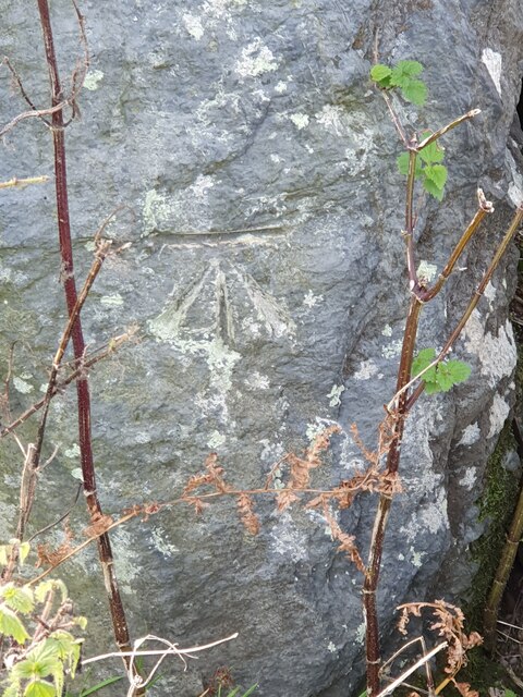
Old Stone Gatepost An old stone gatepost located near Kipscombe Hill, Devon. This post also has an Ordnance Survey bench mark.
<a href="https://www.geograph.org.uk/photo/6998732">SS7649 : Ordnance Survey Bench Mark</a>
Old Stone Gatepost
An old stone gatepost located near Kipscombe Hill, Devon. This post also has an Ordnance Survey bench mark. SS7649 : Ordnance Survey Bench Mark
Ordnance Survey Bench Mark This mark is located on an old stone gatepost near to Kipscombe Hill, Devon. These marks were used by Ordnance Survey for mapping purposes.
<a href="https://www.geograph.org.uk/photo/6998729">SS7649 : Old Stone Gatepost</a>
Ordnance Survey Bench Mark
This mark is located on an old stone gatepost near to Kipscombe Hill, Devon. These marks were used by Ordnance Survey for mapping purposes. SS7649 : Old Stone Gatepost
East Lyn river valley from County Gate
East Lyn River at Ashton Cleave The photo was taken from Cosgates Feet or County Gate, in the square to the right of this one. The view shows the East Lyn River in the valley below, as it meanders around Southern Wood farm and Ashton Cleave. It is located in the south eastern part of the square.
East Lyn River at Ashton Cleave
The photo was taken from Cosgates Feet or County Gate, in the square to the right of this one. The view shows the East Lyn River in the valley below, as it meanders around Southern Wood farm and Ashton Cleave. It is located in the south eastern part of the square.
Countisbury: South West Coast Path View north west to Foreland Point
Countisbury: South West Coast Path
View north west to Foreland Point
Brendon: towards Cranscombe Farm, Scob Hill Seen from Gratton Lane, a minor road linking Malmsmead with Crookhorn Gate. Shot taken on the cusp with SS7647
Brendon: towards Cranscombe Farm, Scob Hill
Seen from Gratton Lane, a minor road linking Malmsmead with Crookhorn Gate. Shot taken on the cusp with SS7647
Countisbury: Kipscombe Farm At the head of Kipscombe, the farm is sheltered from the prevailing winds
Countisbury: Kipscombe Farm
At the head of Kipscombe, the farm is sheltered from the prevailing winds
Malmsmead Hill, Exmoor Photo showing footpath up to road across Malmsmead Hill, Exmoor.
Malmsmead Hill, Exmoor
Photo showing footpath up to road across Malmsmead Hill, Exmoor.
Southern Wood Looking up the East Lyn Valley, as it meanders around the edge of Southern Wood
Southern Wood
Looking up the East Lyn Valley, as it meanders around the edge of Southern Wood
Leeford and Brendon This looks westwards, down the valley of the East Lyn River towards the small rural communities of Leeford and Brendon.
Leeford and Brendon
This looks westwards, down the valley of the East Lyn River towards the small rural communities of Leeford and Brendon.
East Lyn valley near Leeford Looking south-east across the East Lyn valley from the Samaritans Way (SW) on the northern side of Exmoor; route of the stream is shown by line of trees.
East Lyn valley near Leeford
Looking south-east across the East Lyn valley from the Samaritans Way (SW) on the northern side of Exmoor; route of the stream is shown by line of trees.
East Lyn river at Alderford Near Alderford the East Lyn valley starts to become narrower as the river begins its descent towards Watersmeet and Lynmouth. Taken looking south from the Samaritans Way near the edge of Mill Wood.
East Lyn river at Alderford
Near Alderford the East Lyn valley starts to become narrower as the river begins its descent towards Watersmeet and Lynmouth. Taken looking south from the Samaritans Way near the edge of Mill Wood.
Pool on the East Lyn near Wilsham Picturesque spot in the depths of the wooded East Lyn valley on the Samaritans Way SW; Taken looking roughly NW.
Pool on the East Lyn near Wilsham
Picturesque spot in the depths of the wooded East Lyn valley on the Samaritans Way SW; Taken looking roughly NW.
Between Tippacott and Slocombeslade The signpost reads, Brendon 1, Lynmouth 4, Lynton 5. The footpath signed right heads off into Lorna Doone country.
Between Tippacott and Slocombeslade
The signpost reads, Brendon 1, Lynmouth 4, Lynton 5. The footpath signed right heads off into Lorna Doone country.
Brendon Village From the garden of the Staghunters Inn
Brendon Village
From the garden of the Staghunters Inn
Exmoor Hillside A rough grassy hillside above Brendon
Exmoor Hillside
A rough grassy hillside above Brendon
Meeting of Bridleways Sign Post reads:
Left: Bridleway  Dry Bridge 1¼
Right: Bridleway  Badgworthy Valley 2½, Malmsmead 3
Ahead (out of sight) Bridleway Brendon 1¼
Meeting of Bridleways
Sign Post reads: Left: Bridleway Dry Bridge 1¼ Right: Bridleway Badgworthy Valley 2½, Malmsmead 3 Ahead (out of sight) Bridleway Brendon 1¼
Show me another place!

Leeford is located at Grid Ref: SS7748 (Lat: 51.21791, Lng: -3.7625481)

Administrative County: Devon

District: North Devon

Police Authority: Devon and Cornwall

What 3 Words

///charmingly.familiar.enjoys. Near Lynton, Devon

Nearby Locations

Leeford

Related Wikis

Brendon

Brendon is a village and former civil parish, now in the parish of Brendon and Countisbury, in the North Devon district, in the county of Devon, England...

Brendon and Countisbury

Brendon and Countisbury is an English civil parish in the district of North Devon and the county of Devon. The civil parish was created on 1 April 2013...

Malmsmead

Malmsmead is a hamlet on the border between the English counties of Devon and Somerset. The nearest town is Lynton, which lies approximately 4.7 miles...

Malmsmead Bridge

Malmsmead Bridge is a 17th-century stone bridge which crosses Badgworthy Water in the hamlet of Malmsmead, on the road between Oare and Brendon. The Badgworthy...

Nearby Amenities

Located within 500m of 51.21791,-3.7625481
Brendon
Is In: Devon
Place: village
Wikidata: Q1217620
Lat/Long: 51.2200684/-3.7642682
Pub
Staghunters Inn
Wikidata: Q79837580
Lat/Long: 51.2194799/-3.7664586
Post Box
Collection Times: Mo-Fr 15:45; Sa 11:00
Post Box Type: lamp
Ref: EX35 193
Royal Cypher: EIIR
Royal Cypher Wikidata: Q33102113
Lat/Long: 51.220015/-3.7653459
Building: yes
Lat/Long: 51.2195354/-3.7690299
Barn Farm
Place: farm
Lat/Long: 51.2196732/-3.7625121
Building: yes
Lat/Long: 51.2155403/-3.7686249
Building: yes
Lat/Long: 51.2200125/-3.763636
Telephone
Booth: K6
Covered: booth
Lat/Long: 51.2186239/-3.76918
Bench
Lat/Long: 51.2198973/-3.7630802
Barrier: kissing_gate
Source: survey;gps
Lat/Long: 51.2215092/-3.7613113
The data included in this document is from www.openstreetmap.org. The data is made available under ODbL.

Have you been to Leeford?

Leave your review of Leeford below (or comments, questions and feedback).