Waingate Bottom

Valley in Yorkshire Richmondshire

England

Waingate Bottom

Ford over Great Sleddale Beck The track crosses and recrosses the beck several times.Walkers are best advised to stay on one side!
Ford over Great Sleddale Beck Credit: David Brown

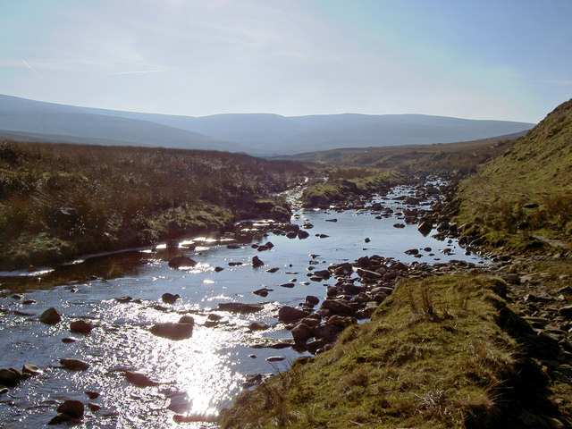
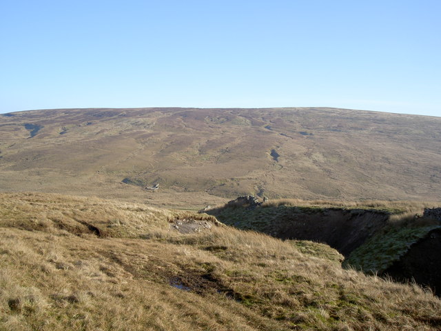
Waingate Bottom is a picturesque valley located in the county of Yorkshire, England. Situated in the heart of the stunning Yorkshire Dales National Park, this valley offers visitors a serene and idyllic setting to explore and enjoy the great outdoors.

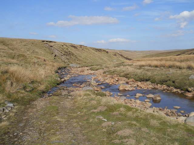
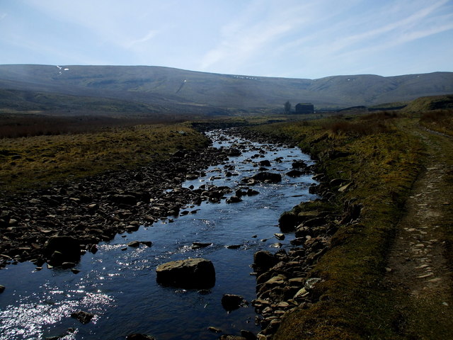
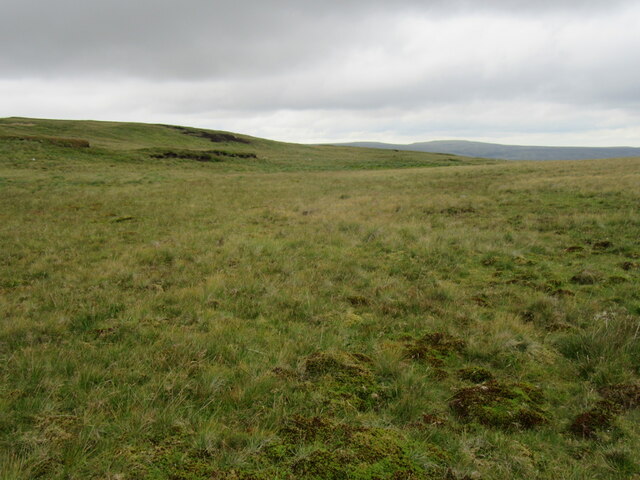
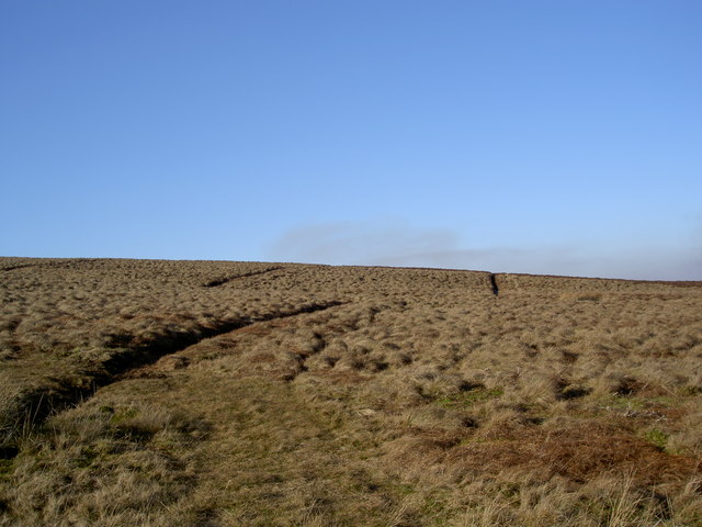
The valley is characterized by its lush green meadows, rolling hills, and meandering streams, all surrounded by towering limestone cliffs and rocky outcrops. It is renowned for its breathtaking natural beauty, making it a popular destination for hikers, nature enthusiasts, and photographers.

Waingate Bottom is home to a diverse range of flora and fauna, with its rich biodiversity attracting numerous species of birds, mammals, and plant life. Visitors can spot wildflowers carpeting the meadows in spring and summer, while sheep and cattle graze peacefully in the fields.

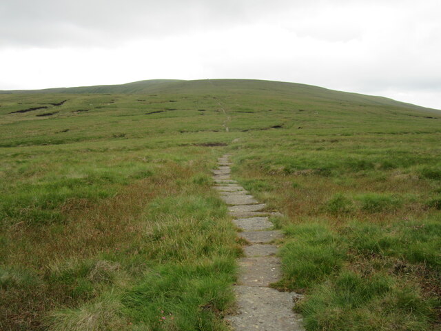
There are several walking trails that wind their way through the valley, providing visitors with the opportunity to explore its hidden gems and discover its tranquil spots. The trails lead to scenic viewpoints, cascading waterfalls, and ancient ruins, offering stunning vistas of the surrounding countryside.

For those seeking adventure, Waingate Bottom also offers opportunities for rock climbing and abseiling on its rugged cliffs. Additionally, the valley is a haven for wildlife enthusiasts, with birdwatching and wildlife spotting being popular activities.

Overall, Waingate Bottom is a true natural gem in Yorkshire, offering visitors a chance to immerse themselves in the beauty of the Yorkshire Dales and experience the tranquility of this stunning valley.

If you have any feedback on the listing, please let us know in the comments section below.

Waingate Bottom Images

Images are sourced within 2km of 54.384806/-2.2466812 or Grid Reference SD8498. Thanks to Geograph Open Source API. All images are credited.

Ford over Great Sleddale Beck The track crosses and recrosses the beck several times.Walkers are best advised to stay on one side!
Ford over Great Sleddale Beck
The track crosses and recrosses the beck several times.Walkers are best advised to stay on one side!
Great Sled Dale Beck Its waters drain the northern & western slopes of Great Shunner Fell and Angram Common, seen in this shot, and the eastern slopes of Hugh Seat and Burnt Moor.
Great Sled Dale Beck
Its waters drain the northern & western slopes of Great Shunner Fell and Angram Common, seen in this shot, and the eastern slopes of Hugh Seat and Burnt Moor.
The Pennine Way on Great Shunner Fell
Approaching Great Shunner Fell The climb ahead is the start of Great Shunner Fell
Approaching Great Shunner Fell
The climb ahead is the start of Great Shunner Fell
On Great Shunner Fell On the lower plateau of Great Shunner Fell.
On Great Shunner Fell
On the lower plateau of Great Shunner Fell.
Great Shunner Fell summit The summit of Great Shunner Fell at 716m ASL.
Great Shunner Fell summit
The summit of Great Shunner Fell at 716m ASL.
Great Sleddale Beck
Great Sleddale Beck
The remains of the northern wall of the extensive Sleddale House sheepfold system
Burnt Moor There are not a lot of features in this square. A couple of drainage ditches are in shot and an couple of grouse are not!
Burnt Moor
There are not a lot of features in this square. A couple of drainage ditches are in shot and an couple of grouse are not!
Icicles hanging over Great Sleddale Beck
Ruin on Burnt Moor
Ruin on Burnt Moor
Looking across Burnt Moor towards Great Sleddale
The head of Stackers Gill Don't stand on the green bits!
The head of Stackers Gill
Don't stand on the green bits!
Looking down Watery Gill
Knoutberry Currack A small pile of stones and a corner in a fence
Knoutberry Currack
A small pile of stones and a corner in a fence
Sleddale Pasture
Sleddale Pasture
Knoutberry Currack A venerable but unremarkable cairn on Angram Common west of Great Shunner Fell. It does have a fine outlook over Great Sleddale with the North Pennines visible on the horizon.
Knoutberry Currack
A venerable but unremarkable cairn on Angram Common west of Great Shunner Fell. It does have a fine outlook over Great Sleddale with the North Pennines visible on the horizon.
Summit shelter, Great Shunner Fell The low-angled, late afternoon sunshine of a winter day reddens the scene at the summit of Great Shunner Fell where a frost has persisted throughout the day. Even the distant fence appears to have retained a little hoarfrost.
Summit shelter, Great Shunner Fell
The low-angled, late afternoon sunshine of a winter day reddens the scene at the summit of Great Shunner Fell where a frost has persisted throughout the day. Even the distant fence appears to have retained a little hoarfrost.
Show me another place!

Waingate Bottom is located at Grid Ref: SD8498 (Lat: 54.384806, Lng: -2.2466812)

Division: North Riding

Administrative County: North Yorkshire

District: Richmondshire

Police Authority: North Yorkshire

What 3 Words

///arranges.positive.confident. Near Kirkby Stephen, Cumbria

Nearby Locations

Waingate Bottom

Related Wikis

Great Shunner Fell

Great Shunner Fell is the third-highest mountain in the Yorkshire Dales, North Yorkshire, England, and the highest point in Wensleydale; at 716 metres...

Hugh Seat

Hugh Seat is a mountain, or more accurately a fell, in Mallerstang on the eastern edge of Cumbria, England. It lies on the border between Cumbria and North...

Vale of Eden

The Vale of Eden is formed by the course of the River Eden, one of the major rivers of Northwest England. It is however of much greater extent than the...

Birkdale, North Yorkshire

Birkdale (sometimes written out as Birk Dale) is a dale in the Yorkshire Dales National Park, in North Yorkshire, England. It lies at the far western end...

Nearby Amenities

Located within 500m of 54.384806,-2.2466812
Natural: sinkhole
Sinkhole: ponor
Lat/Long: 54.3856124/-2.2541199
Natural: sinkhole
Sinkhole: ponor
Lat/Long: 54.3851737/-2.2539477
Natural: sinkhole
Sinkhole: ponor
Lat/Long: 54.3853893/-2.2542173
Natural: sinkhole
Sinkhole: ponor
Lat/Long: 54.3854347/-2.2535548
Natural: sinkhole
Sinkhole: ponor
Lat/Long: 54.3856616/-2.2533242
Natural: sinkhole
Sinkhole: ponor
Lat/Long: 54.3856635/-2.2534281
Natural: sinkhole
Sinkhole: ponor
Lat/Long: 54.3872078/-2.2519547
Natural: sinkhole
Sinkhole: ponor
Lat/Long: 54.3872605/-2.2517148
Natural: sinkhole
Sinkhole: ponor
Lat/Long: 54.3872994/-2.2515025
Natural: sinkhole
Sinkhole: ponor
Lat/Long: 54.386695/-2.2453393
Natural: sinkhole
Sinkhole: ponor
Lat/Long: 54.386624/-2.2462791
Natural: sinkhole
Sinkhole: ponor
Lat/Long: 54.3866148/-2.2460274
Natural: sinkhole
Sinkhole: ponor
Lat/Long: 54.3865164/-2.2465544
Natural: sinkhole
Sinkhole: ponor
Lat/Long: 54.3827006/-2.2449629
Natural: sinkhole
Sinkhole: ponor
Lat/Long: 54.3827755/-2.2448819
Natural: sinkhole
Sinkhole: ponor
Lat/Long: 54.3829086/-2.2446677
Natural: sinkhole
Sinkhole: ponor
Lat/Long: 54.3829724/-2.2445962
Natural: sinkhole
Sinkhole: ponor
Lat/Long: 54.3830223/-2.2445724
Natural: sinkhole
Sinkhole: ponor
Lat/Long: 54.3830888/-2.2444296
Natural: sinkhole
Sinkhole: ponor
Lat/Long: 54.3831803/-2.2442391
Natural: sinkhole
Sinkhole: ponor
Lat/Long: 54.3834271/-2.243963
Natural: sinkhole
Sinkhole: ponor
Lat/Long: 54.3836684/-2.2435868
Natural: sinkhole
Sinkhole: ponor
Lat/Long: 54.3836434/-2.2436868
Natural: sinkhole
Sinkhole: ponor
Lat/Long: 54.3837488/-2.2434868
Natural: sinkhole
Sinkhole: ponor
Lat/Long: 54.3838347/-2.2430726
Natural: sinkhole
Sinkhole: ponor
Lat/Long: 54.3838264/-2.243363
Natural: sinkhole
Sinkhole: ponor
Lat/Long: 54.3833218/-2.245139
Natural: sinkhole
Sinkhole: ponor
Lat/Long: 54.3840372/-2.2447581
Natural: sinkhole
Sinkhole: ponor
Lat/Long: 54.3845196/-2.2443391
Natural: sinkhole
Sinkhole: ponor
Lat/Long: 54.3839013/-2.2441058
Natural: sinkhole
Sinkhole: ponor
Lat/Long: 54.3840094/-2.2441867
Natural: sinkhole
Sinkhole: ponor
Lat/Long: 54.384051/-2.242744
Natural: sinkhole
Sinkhole: ponor
Lat/Long: 54.384295/-2.2425202
Natural: sinkhole
Sinkhole: ponor
Lat/Long: 54.3844808/-2.2422107
Natural: sinkhole
Sinkhole: ponor
Lat/Long: 54.3846832/-2.241825
Natural: sinkhole
Sinkhole: ponor
Lat/Long: 54.3846001/-2.2418679
Natural: sinkhole
Sinkhole: ponor
Lat/Long: 54.3847914/-2.2415155
Natural: sinkhole
Sinkhole: ponor
Lat/Long: 54.3848746/-2.2410346
Natural: sinkhole
Sinkhole: ponor
Lat/Long: 54.3846555/-2.2409584
Natural: sinkhole
Sinkhole: ponor
Lat/Long: 54.3851491/-2.2408537
Natural: sinkhole
Sinkhole: ponor
Lat/Long: 54.3851047/-2.2412917
Natural: sinkhole
Sinkhole: ponor
Lat/Long: 54.3851269/-2.2415489
Natural: sinkhole
Sinkhole: ponor
Lat/Long: 54.3851352/-2.2419012
Natural: sinkhole
Sinkhole: ponor
Lat/Long: 54.3852711/-2.2419774
Natural: sinkhole
Sinkhole: ponor
Lat/Long: 54.38526/-2.2416489
Natural: sinkhole
Sinkhole: ponor
Lat/Long: 54.3853293/-2.2413489
Natural: sinkhole
Sinkhole: ponor
Lat/Long: 54.3851269/-2.2425821
Natural: sinkhole
Sinkhole: ponor
Lat/Long: 54.3849272/-2.242725
Natural: sinkhole
Sinkhole: ponor
Lat/Long: 54.3848801/-2.2427964
Natural: sinkhole
Sinkhole: ponor
Lat/Long: 54.3850271/-2.2436773
Natural: sinkhole
Sinkhole: ponor
Lat/Long: 54.3847692/-2.2442486
Natural: sinkhole
Sinkhole: ponor
Lat/Long: 54.3847304/-2.2444772
Natural: sinkhole
Sinkhole: ponor
Lat/Long: 54.3852212/-2.2431249
Natural: sinkhole
Sinkhole: ponor
Lat/Long: 54.3850936/-2.2433773
Natural: sinkhole
Sinkhole: ponor
Lat/Long: 54.3850631/-2.2434154
Natural: sinkhole
Sinkhole: ponor
Lat/Long: 54.3850132/-2.243463
Natural: sinkhole
Sinkhole: ponor
Lat/Long: 54.3845557/-2.2431868
Natural: sinkhole
Sinkhole: ponor
Lat/Long: 54.3855234/-2.2409632
Natural: sinkhole
Sinkhole: ponor
Lat/Long: 54.3854596/-2.2418203
Natural: sinkhole
Sinkhole: ponor
Lat/Long: 54.3857452/-2.2420012
Natural: sinkhole
Sinkhole: ponor
Lat/Long: 54.3858312/-2.2417536
Natural: sinkhole
Sinkhole: ponor
Lat/Long: 54.3855483/-2.2426964
Natural: sinkhole
Sinkhole: ponor
Lat/Long: 54.3855178/-2.2429059
Natural: sinkhole
Sinkhole: ponor
Lat/Long: 54.3854042/-2.2435058
Natural: sinkhole
Sinkhole: ponor
Lat/Long: 54.3853321/-2.2426345
Natural: sinkhole
Sinkhole: ponor
Lat/Long: 54.3852711/-2.2421202
Natural: sinkhole
Sinkhole: ponor
Lat/Long: 54.3862693/-2.2422488
Natural: sinkhole
Sinkhole: ponor
Lat/Long: 54.3864994/-2.2422679
Natural: sinkhole
Sinkhole: ponor
Lat/Long: 54.3863275/-2.2420441
Natural: sinkhole
Sinkhole: ponor
Lat/Long: 54.3862637/-2.2420345
Natural: sinkhole
Sinkhole: ponor
Lat/Long: 54.3863608/-2.2417155
Natural: sinkhole
Sinkhole: ponor
Lat/Long: 54.3864273/-2.2416203
Natural: sinkhole
Sinkhole: ponor
Lat/Long: 54.3863663/-2.2418203
Natural: sinkhole
Sinkhole: ponor
Lat/Long: 54.3865188/-2.242125
Natural: sinkhole
Sinkhole: ponor
Lat/Long: 54.3864883/-2.2421726
Natural: sinkhole
Sinkhole: ponor
Lat/Long: 54.3865105/-2.2419488
Natural: sinkhole
Sinkhole: ponor
Lat/Long: 54.3865549/-2.2415155
Natural: sinkhole
Sinkhole: ponor
Lat/Long: 54.386028/-2.2404299
Natural: sinkhole
Sinkhole: ponor
Lat/Long: 54.3861999/-2.2397347
Natural: sinkhole
Sinkhole: ponor
Lat/Long: 54.3833408/-2.2471866
Natural: sinkhole
Sinkhole: ponor
Lat/Long: 54.3834675/-2.2467838
Natural: sinkhole
Sinkhole: ponor
Lat/Long: 54.3835659/-2.2464883
Natural: sinkhole
Sinkhole: ponor
Lat/Long: 54.3830684/-2.2464721
Natural: sinkhole
Sinkhole: ponor
Lat/Long: 54.3828358/-2.2467579
Natural: sinkhole
Sinkhole: ponor
Lat/Long: 54.3828547/-2.2465273
Natural: sinkhole
Sinkhole: ponor
Lat/Long: 54.3830193/-2.2469397
Natural: sinkhole
Sinkhole: ponor
Lat/Long: 54.3835432/-2.2475925
Natural: sinkhole
Sinkhole: ponor
Lat/Long: 54.3837796/-2.2492683
Natural: sinkhole
Sinkhole: ponor
Lat/Long: 54.3838912/-2.2493203
Natural: sinkhole
Sinkhole: ponor
Lat/Long: 54.3842354/-2.2498367
Natural: sinkhole
Sinkhole: ponor
Lat/Long: 54.3841389/-2.2491092
Natural: sinkhole
Sinkhole: ponor
Lat/Long: 54.3838552/-2.2487584
Natural: sinkhole
Sinkhole: ponor
Lat/Long: 54.3840519/-2.2488786
Natural: sinkhole
Sinkhole: ponor
Lat/Long: 54.383946/-2.2488851
Natural: sinkhole
Sinkhole: ponor
Lat/Long: 54.3839952/-2.2491352
Natural: sinkhole
Sinkhole: ponor
Lat/Long: 54.3837909/-2.2490865
Natural: sinkhole
Sinkhole: ponor
Lat/Long: 54.3844396/-2.2486155
The data included in this document is from www.openstreetmap.org. The data is made available under ODbL.

Have you been to Waingate Bottom?

Leave your review of Waingate Bottom below (or comments, questions and feedback).