Crag Clough

Valley in Yorkshire Ribble Valley

England

Crag Clough

Transmitter mast at Weets House Farm The location was presumably selected as it's on the shoulder of the hill between two valleys, to give coverage to both.
Transmitter mast at Weets House Farm Credit: Stephen Craven

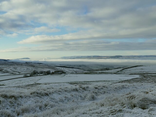
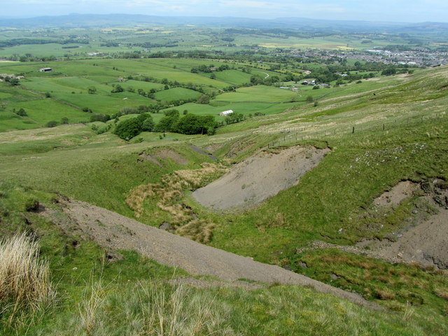
Crag Clough is a picturesque valley located in the county of Yorkshire, England. Nestled in the heart of the Pennines, it is renowned for its natural beauty and stunning landscapes. The valley stretches for approximately 3 miles, bordered by rolling hills and rugged moorlands, creating a sense of tranquility and remoteness.

The landscape of Crag Clough is dominated by a meandering river that runs through the valley, carving its way through the rocky terrain. The river is flanked by lush green meadows and dense woodlands, providing a habitat for a diverse range of flora and fauna. Visitors to the valley can often spot various species of birds, including kingfishers and herons, as well as small mammals like otters and voles.

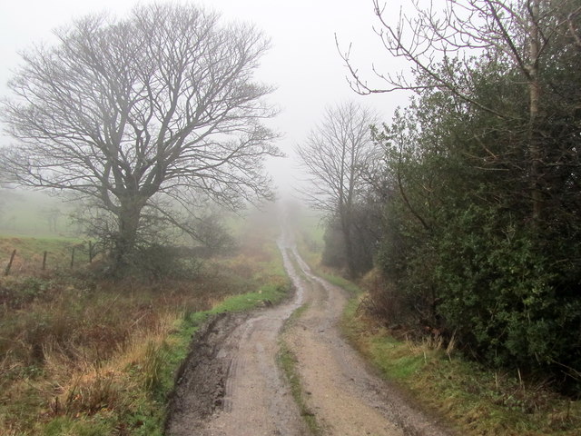
The valley offers a multitude of walking trails, ranging from gentle strolls along the riverbank to more challenging hikes up the surrounding hills. The trails provide breathtaking views of the surrounding countryside, allowing visitors to fully appreciate the natural splendor of the area. In addition, the valley is home to several ancient landmarks, such as stone circles and burial mounds, which offer insight into the rich historical heritage of the region.

Crag Clough is a haven for outdoor enthusiasts, with opportunities for activities such as fishing, birdwatching, and picnicking. The valley also attracts artists and photographers, who are drawn to its ethereal beauty and ever-changing scenery. With its idyllic setting and untouched charm, Crag Clough is a must-visit destination for those seeking a peaceful retreat in the heart of Yorkshire.

If you have any feedback on the listing, please let us know in the comments section below.

Crag Clough Images

Images are sourced within 2km of 53.899894/-2.2438738 or Grid Reference SD8444. Thanks to Geograph Open Source API. All images are credited.

Transmitter mast at Weets House Farm The location was presumably selected as it's on the shoulder of the hill between two valleys, to give coverage to both.
Transmitter mast at Weets House Farm
The location was presumably selected as it's on the shoulder of the hill between two valleys, to give coverage to both.
Weets House Farm The sign in the foreground indicates they have an alpaca herd. There was no sign of them on this occasion, but surely this is just the sort of weather the Andean creatures have evolved for?
Weets House Farm
The sign in the foreground indicates they have an alpaca herd. There was no sign of them on this occasion, but surely this is just the sort of weather the Andean creatures have evolved for?
Gate across Gisburn Old Road This marks the end of the road for motor vehicles coming from Blacko direction. beyond it the road becomes just the Pennine Bridleway. The sign beyond the wall indicates that the Pendle Way that shares the last section of tarmac road turns right here over the hill towards Barnoldswick.
Gate across Gisburn Old Road
This marks the end of the road for motor vehicles coming from Blacko direction. beyond it the road becomes just the Pennine Bridleway. The sign beyond the wall indicates that the Pendle Way that shares the last section of tarmac road turns right here over the hill towards Barnoldswick.
View across to Pendle from Weets House Pendle is 6km west-south-west from here, and the summit about 150m higher.
View across to Pendle from Weets House
Pendle is 6km west-south-west from here, and the summit about 150m higher.
Cold Weather House The farm in the middle distance is well named for this December view. Further ahead, a temperature inversion leaves Ribblesdale filled with low cloud.
Cold Weather House
The farm in the middle distance is well named for this December view. Further ahead, a temperature inversion leaves Ribblesdale filled with low cloud.
Frozen puddle on Weets Hill With Pendle in the distance. Location approximate.
Frozen puddle on Weets Hill
With Pendle in the distance. Location approximate.
Raven on Weets Hill triangulation pillar It could be a crow, but compared with the size of the standard pillar it's a big bird. I'm going with raven, as  they are not unknown in the Pennines. Photographed from a distance to catch it before it inevitably flew off as I approached.
Raven on Weets Hill triangulation pillar
It could be a crow, but compared with the size of the standard pillar it's a big bird. I'm going with raven, as they are not unknown in the Pennines. Photographed from a distance to catch it before it inevitably flew off as I approached.
Weets Hill triangulation pillar The pillar is close to the 397 metre summit of the hill, which is a good vantage point. Pendle is in the background of this view, with (I think) Longridge Fell peeking up out of the valley fog beyond.
Weets Hill triangulation pillar
The pillar is close to the 397 metre summit of the hill, which is a good vantage point. Pendle is in the background of this view, with (I think) Longridge Fell peeking up out of the valley fog beyond.
Weets Hill triangulation pillar - plaque I had to wipe the snow off this plaque to read it. It is on the north side of the base of the pillar <a href="https://www.geograph.org.uk/photo/7361560">SD8544 : Weets Hill triangulation pillar</a> and reads 'In loving memory of Garth Standen 7.11.43 - 21.9.15'.
Weets Hill triangulation pillar - plaque
I had to wipe the snow off this plaque to read it. It is on the north side of the base of the pillar SD8544 : Weets Hill triangulation pillar and reads 'In loving memory of Garth Standen 7.11.43 - 21.9.15'.
A seat above the clouds The bench is just below Weets Hill triangulation pillar. With a temperature inversion filling the valley with cloud, only the tops of the Yorkshire fells could be seen in this direction. <a href="https://www.geograph.org.uk/photo/5217981">SD8544 : A bench with a view</a> shows the view on a clear day.
A seat above the clouds
The bench is just below Weets Hill triangulation pillar. With a temperature inversion filling the valley with cloud, only the tops of the Yorkshire fells could be seen in this direction. SD8544 : A bench with a view shows the view on a clear day.
View north from Weets Hill With a temperature inversion filling the valley with cloud, only the tops of the Yorkshire fells, including Ingleborough and Pen-y-Ghent, could be seen in this direction.
View north from Weets Hill
With a temperature inversion filling the valley with cloud, only the tops of the Yorkshire fells, including Ingleborough and Pen-y-Ghent, could be seen in this direction.
Rayk at Weets Hill trig. point
Approaching Weets House The Gisburn Old Road is metalled only to this point, becoming a rough track as it continues northwards.  The road is also adopted by the Pendle Way long distance footpath
Approaching Weets House
The Gisburn Old Road is metalled only to this point, becoming a rough track as it continues northwards. The road is also adopted by the Pendle Way long distance footpath
Pendle Way leading up Weets Hill The long distance footpath leaves Gisburn Old Road to climb up towards the summit of Weets Hill beside the broken dry stone wall
Pendle Way leading up Weets Hill
The long distance footpath leaves Gisburn Old Road to climb up towards the summit of Weets Hill beside the broken dry stone wall
Gully on the Flanks of Weet Hill Above a deep gully on the northern flanks of Weets Hill
Gully on the Flanks of Weet Hill
Above a deep gully on the northern flanks of Weets Hill
Flass House Farm in the Mist Brogden Lane passing Flass House Farm on a miserable misty winters day
Flass House Farm in the Mist
Brogden Lane passing Flass House Farm on a miserable misty winters day
Coal Pit Lane Unmetalled Lane descending gradually towards the Ribble Valley, recently adopted by the Pennine Bridleway.
Coal Pit Lane
Unmetalled Lane descending gradually towards the Ribble Valley, recently adopted by the Pennine Bridleway.
Access Drive to Coverdale The driveway seen on a rather grim misty day, from Coal Pit Lane
Access Drive to Coverdale
The driveway seen on a rather grim misty day, from Coal Pit Lane
Show me another place!

Crag Clough is located at Grid Ref: SD8444 (Lat: 53.899894, Lng: -2.2438738)

Division: West Riding

Administrative County: Lancashire

District: Ribble Valley

Police Authority: Lancashire

What 3 Words

///file.wedding.expectant. Near Barnoldswick, Lancashire

Nearby Locations

Middop Crag Clough

Related Wikis

Middop

Middop is a rural hamlet and civil parish in Lancashire, England. It is in Ribble Valley district. Middop is near the villages of Rimington and Gisburn...

Weets Hill

Weets Hill is a hill in the West Craven area of Pendle, Lancashire, England. It is 2+1⁄2 miles (4.0 km) south-west of the town of Barnoldswick and is 4...

Twiston

Twiston is a village and a civil parish in the Ribble Valley District, in the English county of Lancashire. It is near the town of Clitheroe and the village...

Rimington

Rimington is a rural village and civil parish in the Ribble Valley, Lancashire, England. The population of the civil parish was 382 at the 2001 Census...

Nearby Amenities

Located within 500m of 53.899894,-2.2438738
Power: pole
Lat/Long: 53.8979427/-2.2374666
Power: pole
Lat/Long: 53.8983536/-2.2374237
Power: pole
Lat/Long: 53.8988277/-2.2374049
Power: pole
Lat/Long: 53.8996226/-2.2373861
Power: pole
Lat/Long: 53.9002279/-2.237362
Power: pole
Lat/Long: 53.9010386/-2.2373432
Power: pole
Lat/Long: 53.9018224/-2.2373137
The data included in this document is from www.openstreetmap.org. The data is made available under ODbL.

Have you been to Crag Clough?

Leave your review of Crag Clough below (or comments, questions and feedback).