Deep Dale

Valley in Yorkshire Ribble Valley

England

Deep Dale

Ordnance Survey Cut Mark This mark can be found on a field gatepost beside knot Lane at White Hill.
The benchmark has a recorded height of 153.6954 metres above sea level.
For more detail see : <span class="nowrap"><a title="https://www.bench-marks.org.uk/bm121976" rel="nofollow ugc noopener" href="https://www.bench-marks.org.uk/bm121976">Link</a><img style="margin-left:2px;" alt="External link" title="External link - shift click to open in new window" src="https://s1.geograph.org.uk/img/external.png" width="10" height="10"/></span>
Ordnance Survey Cut Mark Credit: Peter Wood

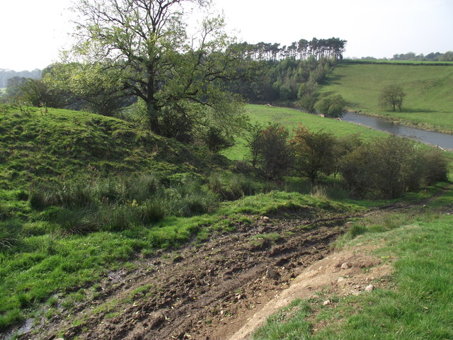
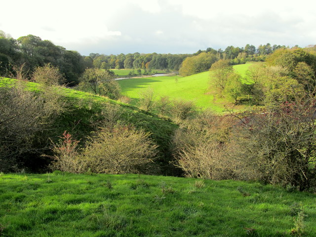
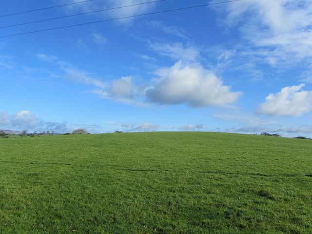
Deep Dale is a picturesque valley located in the heart of Yorkshire, England. Nestled amidst the rolling hills and lush green fields, this serene and tranquil destination is a haven for nature lovers and outdoor enthusiasts. The valley stretches for approximately 5 miles and is characterized by its steep sides, which are adorned with dense woodlands and scattered with wildflowers during the summer months.

The centerpiece of Deep Dale is a meandering river that flows through its heart, providing a constant source of beauty and tranquility. The crystal-clear waters are home to a variety of freshwater fish and attract an array of wildlife, including ducks, herons, and occasionally otters.

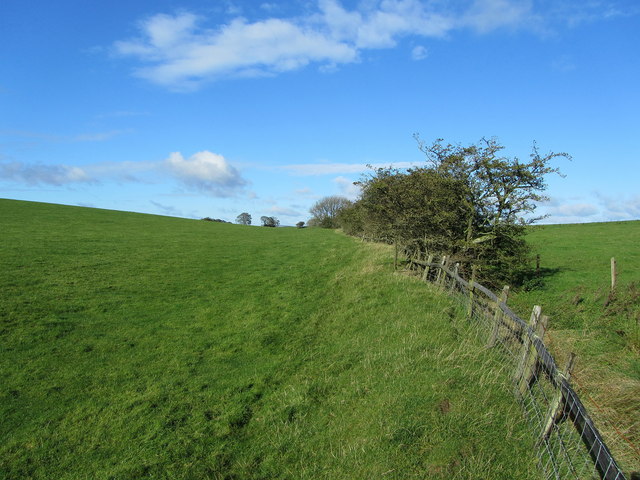
Walking and hiking trails crisscross the valley, offering visitors the opportunity to explore its natural wonders. The paths wind through ancient woodlands, carpeted with bluebells in the spring and vibrant foliage in the autumn. As you ascend the valley, the breathtaking views of the surrounding countryside unfold, showcasing the patchwork fields and distant moorlands that Yorkshire is renowned for.

Deep Dale is also steeped in history, with remnants of stone walls and old farm buildings dotting the landscape. The valley has provided a tranquil and idyllic setting for generations of farmers, who have cultivated the land and tended to their livestock.

For those seeking a peaceful retreat in the heart of nature, Deep Dale offers a sanctuary away from the hustle and bustle of modern life. With its stunning landscapes, diverse wildlife, and rich history, this hidden gem in Yorkshire is a must-visit destination for anyone seeking solace in the great outdoors.

If you have any feedback on the listing, please let us know in the comments section below.

Deep Dale Images

Images are sourced within 2km of 53.940397/-2.2506759 or Grid Reference SD8349. Thanks to Geograph Open Source API. All images are credited.

Ordnance Survey Cut Mark This mark can be found on a field gatepost beside knot Lane at White Hill.
The benchmark has a recorded height of 153.6954 metres above sea level.
For more detail see : <span class="nowrap"><a title="https://www.bench-marks.org.uk/bm121976" rel="nofollow ugc noopener" href="https://www.bench-marks.org.uk/bm121976">Link</a><img style="margin-left:2px;" alt="External link" title="External link - shift click to open in new window" src="https://s1.geograph.org.uk/img/external.png" width="10" height="10"/></span>
Ordnance Survey Cut Mark
This mark can be found on a field gatepost beside knot Lane at White Hill. The benchmark has a recorded height of 153.6954 metres above sea level. For more detail see : LinkExternal link
Ordnance Survey Cut Mark This mark can be found on the parapet wall of Paythorne Bridge
The benchmark has a recorded height of 104.7627 metres above sea level.
For more detail see : <span class="nowrap"><a title="https://www.bench-marks.org.uk/bm45450" rel="nofollow ugc noopener" href="https://www.bench-marks.org.uk/bm45450">Link</a><img style="margin-left:2px;" alt="External link" title="External link - shift click to open in new window" src="https://s1.geograph.org.uk/img/external.png" width="10" height="10"/></span>
Ordnance Survey Cut Mark
This mark can be found on the parapet wall of Paythorne Bridge The benchmark has a recorded height of 104.7627 metres above sea level. For more detail see : LinkExternal link
Ordnance Survey Cut Mark This mark can be found on the wall of St Mary's Church, Gisburn
The benchmark has a recorded height of 138.3304 metres above sea level.
For more detail see : <span class="nowrap"><a title="https://www.bench-marks.org.uk/bm36317" rel="nofollow ugc noopener" href="https://www.bench-marks.org.uk/bm36317">Link</a><img style="margin-left:2px;" alt="External link" title="External link - shift click to open in new window" src="https://s1.geograph.org.uk/img/external.png" width="10" height="10"/></span>
Ordnance Survey Cut Mark
This mark can be found on the wall of St Mary's Church, Gisburn The benchmark has a recorded height of 138.3304 metres above sea level. For more detail see : LinkExternal link
Delicious Deli and Café - Gisburn
Gutteridge Farm
Gutteridge Farm
Fields East of Gisburn
West Portal Gisburne Park  Railway Tunnel A cut and cover short tunnel required by the landowner and decorated appropriately. The turrets of the east portal can be seen as well across this part of Gisburne Park
West Portal Gisburne Park Railway Tunnel
A cut and cover short tunnel required by the landowner and decorated appropriately. The turrets of the east portal can be seen as well across this part of Gisburne Park
Gisburne Park Railway Tunnel Turrets A curious view of mock castle turrets in parkland, disguising a railway line
Gisburne Park Railway Tunnel Turrets
A curious view of mock castle turrets in parkland, disguising a railway line
Old milestone This milestone which would have stood at the southeast corner of the A59/B6265 Bracewll Lane is now built into steps at the back of the White Bull PH in Gisburn.  This face is engraved with a hand pointing left/To/SKipton/9 Miles/hand pointing right/Gisbor(n)/2 Ms.  The other visible face is engraved with a hand pointing left To/Settle 11 ms/hand to right/Colne 7 ms.
Old milestone
This milestone which would have stood at the southeast corner of the A59/B6265 Bracewll Lane is now built into steps at the back of the White Bull PH in Gisburn. This face is engraved with a hand pointing left/To/SKipton/9 Miles/hand pointing right/Gisbor(n)/2 Ms. The other visible face is engraved with a hand pointing left To/Settle 11 ms/hand to right/Colne 7 ms.
Gisburne Park Entrance Lodges At the south entrance at the end of Park Road from the centre of Gisburn
Gisburne Park Entrance Lodges
At the south entrance at the end of Park Road from the centre of Gisburn
Looking down to the Ribble From the Ribble Way. Heavy vehicles have recently churned up the ground.
Looking down to the Ribble
From the Ribble Way. Heavy vehicles have recently churned up the ground.
A  View over the Ribble Valley The Ribble south of Paythorne seen from near Castle Haugh
A View over the Ribble Valley
The Ribble south of Paythorne seen from near Castle Haugh
Knot Lane Narrow country lane from the hamlet of Horton leading towards the A682 at Newsholme
Knot Lane
Narrow country lane from the hamlet of Horton leading towards the A682 at Newsholme
White Hill Small drumlin off Knot Lane
White Hill
Small drumlin off Knot Lane
Boundary Fence between White and Hoober Hill Fence follows the saddle between the two drumlins of White Hill and Hoober Hill
Boundary Fence between White and Hoober Hill
Fence follows the saddle between the two drumlins of White Hill and Hoober Hill
Paythorne Bridge Closed to traffic for road resurfacing on the day of my walk but they were happy to let pedestrians through
Paythorne Bridge
Closed to traffic for road resurfacing on the day of my walk but they were happy to let pedestrians through
Pennine Bridleway approaching Castle Haugh from the north I guess the castle is the large earth mound inside the wood
Pennine Bridleway approaching Castle Haugh from the north
I guess the castle is the large earth mound inside the wood
Rivet benchmark on a milestone north of Gisburn Settle 10 miles on the south face, Gisburn 1 mile on the north.   The Ordnance Survey arrow is on the east face
Rivet benchmark on a milestone north of Gisburn
Settle 10 miles on the south face, Gisburn 1 mile on the north. The Ordnance Survey arrow is on the east face
Show me another place!

Deep Dale is located at Grid Ref: SD8349 (Lat: 53.940397, Lng: -2.2506759)

Division: West Riding

Administrative County: Lancashire

District: Ribble Valley

Police Authority: Lancashire

What 3 Words

///kilowatt.bidder.sped. Near Barnoldswick, Lancashire

Related Wikis

Gisburn Tunnel

Gisburn Tunnel is a short railway tunnel on the Ribble Valley line in Lancashire, England. The tunnel is 157 yards (144 m) long, just to the east of Gisburn...

Gisburne Park

Gisburne Park is an 18th-century country house and associated park in Gisburn, Lancashire, England, in the Ribble Valley some 6 miles (10 km) north-east...

Stock Beck

Stock Beck is a minor river in the West Craven area of Pendle, Lancashire (formerly in Yorkshire). It is 8.25 miles (13.27 km) long and has a catchment...

Gisburn railway station

Gisburn railway station served the small village of Gisburn, which is now in Lancashire, England, but was in the West Riding of Yorkshire at the time....

Gisburn

Gisburn (formerly Gisburne) is a village and civil parish within the Ribble Valley borough of Lancashire, England. Historically within the West Riding...

A59 road

The A59 is a major road in England which is around 109 miles (175 km) long and runs from Wallasey, Merseyside to York, North Yorkshire. The alignment formed...

Newsholme railway station

Newsholme railway station was a railway station that served the small village of Newsholme in Lancashire. It was built by the Lancashire and Yorkshire...

Newsholme, Lancashire

Newsholme is a small village and civil parish in the Ribble Valley, Lancashire, England, but lies within the historic West Riding of Yorkshire. According...

Nearby Amenities

Located within 500m of 53.940397,-2.2506759
Crow Park
Building: yes
Source: NPE
Lat/Long: 53.943139/-2.2482247
Deep Dale
Building: yes
Source: NPE
Lat/Long: 53.9407393/-2.2511429
Cow Pasture Hill
Natural: peak
Source: OS 1:25k
Lat/Long: 53.9379941/-2.2569177
Green Hill
Natural: peak
Source: OS 1:25k
Lat/Long: 53.9426548/-2.2568533
Ha-ha Hill
Natural: peak
Source: OS 1:25k
Lat/Long: 53.9443219/-2.2532484
Power: pole
Lat/Long: 53.9366767/-2.2485709
Power: pole
Lat/Long: 53.938393/-2.2489759
Power: pole
Lat/Long: 53.9391162/-2.2491691
Power: pole
Lat/Long: 53.9399166/-2.2493568
Power: pole
Lat/Long: 53.9407313/-2.249566
Power: pole
Lat/Long: 53.9415049/-2.2497296
Power: pole
Lat/Long: 53.9423117/-2.2499335
Power: pole
Lat/Long: 53.9438099/-2.2502714
Power: pole
Lat/Long: 53.9446908/-2.2505155
The data included in this document is from www.openstreetmap.org. The data is made available under ODbL.

Have you been to Deep Dale?

Leave your review of Deep Dale below (or comments, questions and feedback).