Gasdale

Valley in Westmorland Eden

England

Gasdale

Middletongue Crag
Middletongue Crag Credit: habiloid

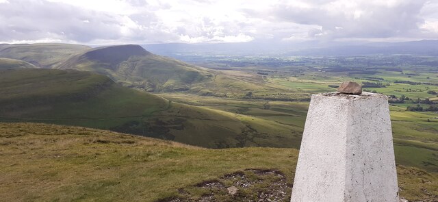
Gasdale is a picturesque valley located in the county of Westmorland, England. Nestled amidst the stunning landscape of the Lake District National Park, Gasdale is known for its natural beauty and tranquility. The valley is situated in the northern part of the national park, offering visitors a peaceful retreat far from the bustling city life.

Surrounded by rolling hills and lush greenery, Gasdale is a haven for nature enthusiasts and hikers. The valley is crisscrossed by several walking trails, providing ample opportunities to explore the breathtaking scenery. One of the notable trails is the Gasdale Valley Walk, which takes visitors through picturesque meadows, babbling brooks, and dense woodlands.

The valley is home to a diverse range of flora and fauna, making it a popular spot for wildlife enthusiasts. Visitors can spot a variety of bird species, including peregrine falcons, buzzards, and owls. The tranquil waters of the rivers and streams in Gasdale are also teeming with fish, attracting anglers from far and wide.

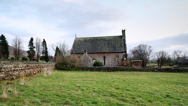
Gasdale is a rural area with a few scattered farmhouses and quaint cottages. The local community is friendly and welcoming, embracing the traditional rural way of life. The valley offers limited amenities, so visitors often venture to nearby towns for shopping and dining experiences.

Overall, Gasdale presents an idyllic setting for those seeking a peaceful retreat amidst unspoiled natural beauty. With its scenic trails, abundant wildlife, and serene atmosphere, Gasdale is a hidden gem in the Lake District National Park.

If you have any feedback on the listing, please let us know in the comments section below.

Gasdale Images

Images are sourced within 2km of 54.598444/-2.4010507 or Grid Reference NY7422. Thanks to Geograph Open Source API. All images are credited.

Middletongue Crag
Middletongue Crag
View from Middletongue Crag
Bridge over Murton Beck, Murton
Murton and Hilton church Situated midway between Murton and its smaller satellite Hilton, the church is dedicated to St. John the Baptist. Its graveyard lies just across the minor road between the villages, and slightly nearer to Hilton, and lies among the tall conifers seen on the left of the view.
Murton and Hilton church
Situated midway between Murton and its smaller satellite Hilton, the church is dedicated to St. John the Baptist. Its graveyard lies just across the minor road between the villages, and slightly nearer to Hilton, and lies among the tall conifers seen on the left of the view.
Track on lower slopes of Murton Pike
Trundale Adjacent valley to the more famous High Cup.
Trundale
Adjacent valley to the more famous High Cup.
Trundale Gill
Trundale Gill
Middletongue Crag
Middletongue Crag
Path above Gasdale
Path above Gasdale
Trig Point on Murton Pike
View to White Mines Former lead mine on the eastern side of Gasdale.
View to White Mines
Former lead mine on the eastern side of Gasdale.
Track on the slopes of Murton Pike
Cumbrian Red Sandstone house, Murton
White Mines Now disused, note abandoned tractor, left where it fell.
White Mines
Now disused, note abandoned tractor, left where it fell.
Murton Pike Looking along the escarpment
Murton Pike
Looking along the escarpment
Trundale Gill Lots of Limestone scree along the valley. Just below Murton Pike
Trundale Gill
Lots of Limestone scree along the valley. Just below Murton Pike
Ordnance Survey Cut Mark This OS cut mark can be found on the east angle of St John's Church. It marks a point 232.361m above mean sea level.
Ordnance Survey Cut Mark
This OS cut mark can be found on the east angle of St John's Church. It marks a point 232.361m above mean sea level.
Ordnance Survey Cut Mark This OS cut mark can be found on the toppled gatepost.
Ordnance Survey Cut Mark
This OS cut mark can be found on the toppled gatepost.
Show me another place!

Gasdale is located at Grid Ref: NY7422 (Lat: 54.598444, Lng: -2.4010507)

Administrative County: Cumbria

District: Eden

Police Authority: Cumbria

What 3 Words

///cheetahs.debating.jingles. Near Appleby-in-Westmorland, Cumbria

Related Wikis

Murton, Cumbria

Murton is a small village and civil parish in the Eden District of Cumbria, England. The parish had a population of 330 in 2001, rising to 360 at the 2011...

Hilton, Cumbria

Hilton is a village in Cumbria, England, in the civil parish of Murton, about 3 miles (4.8 km) east of Appleby-in-Westmorland and at an elevation of 752...

Murton Fell

Murton Fell is a hill of 675 metres (2,215 ft) above the village of Murton, Cumbria in Eden district, in the North Pennines. It lies east of the dramatic...

Warcop Training Area

The Warcop Training Area (WTA) is a UK Ministry of Defence military training area near the village of Warcop in Cumbria. Part of the Defence Training...

Nearby Amenities

Located within 500m of 54.598444,-2.4010507
White Lead Mine
Abandoned: yes
Historic: mine
Man Made: mine
Mineral: lead
Lat/Long: 54.5980531/-2.3967312
Natural: sinkhole
Lat/Long: 54.5999616/-2.4062073
Natural: sinkhole
Lat/Long: 54.6000185/-2.4049021
Natural: sinkhole
Lat/Long: 54.6000029/-2.4044624
Natural: sinkhole
Lat/Long: 54.6000445/-2.404292
Natural: sinkhole
Lat/Long: 54.6000964/-2.4041484
Natural: sinkhole
Lat/Long: 54.5999785/-2.4054351
Natural: sinkhole
Lat/Long: 54.5969991/-2.3942822
Natural: sinkhole
Lat/Long: 54.597155/-2.3941387
Natural: sinkhole
Lat/Long: 54.596812/-2.393892
Natural: sinkhole
Lat/Long: 54.597285/-2.3940355
Natural: sinkhole
Lat/Long: 54.5973292/-2.3939458
Natural: sinkhole
Lat/Long: 54.5978125/-2.3934972
Natural: sinkhole
Lat/Long: 54.5984025/-2.3935062
Natural: sinkhole
Lat/Long: 54.5988965/-2.3938013
Natural: sinkhole
Lat/Long: 54.5989217/-2.3941156
Natural: sinkhole
Lat/Long: 54.5991483/-2.3941022
Natural: sinkhole
Lat/Long: 54.5990689/-2.3942326
Natural: sinkhole
Lat/Long: 54.5991948/-2.3939919
Natural: sinkhole
Lat/Long: 54.5992858/-2.3940287
Natural: sinkhole
Lat/Long: 54.5993207/-2.3941624
Natural: sinkhole
Lat/Long: 54.5995121/-2.3939909
Natural: sinkhole
Lat/Long: 54.5995973/-2.394018
Natural: sinkhole
Lat/Long: 54.5997431/-2.3938398
Natural: sinkhole
Lat/Long: 54.6000797/-2.393956
Abandoned: yes
Historic: adit
Man Made: adit
Lat/Long: 54.5984007/-2.395669
Abandoned: yes
Historic: mine_shaft
Man Made: mineshaft
Lat/Long: 54.5978043/-2.3941531
Ford: yes
Lat/Long: 54.5983836/-2.400528
Abandoned: yes
Direction: 110
Man Made: adit
Lat/Long: 54.5981628/-2.3958778
Abandoned: yes
Direction: 90
Historic: adit
Man Made: adit
Lat/Long: 54.5980869/-2.3973831
Gasdale
Place: locality
Lat/Long: 54.5983508/-2.4012287
Natural: sinkhole
Lat/Long: 54.597933/-2.3954373
Natural: sinkhole
Lat/Long: 54.5946224/-2.3990041
Natural: sinkhole
Lat/Long: 54.5946561/-2.3986401
Natural: sinkhole
Lat/Long: 54.5944698/-2.398489
Natural: sinkhole
Lat/Long: 54.5948176/-2.3986168
Natural: sinkhole
Lat/Long: 54.6027422/-2.3991857
Natural: sinkhole
Lat/Long: 54.6026525/-2.3994142
Natural: sinkhole
Lat/Long: 54.6026525/-2.3995382
Natural: sinkhole
Lat/Long: 54.6026412/-2.3997124
Natural: sinkhole
Lat/Long: 54.6026592/-2.399879
Natural: sinkhole
Lat/Long: 54.6026637/-2.4000339
Natural: sinkhole
Lat/Long: 54.6027018/-2.4001694
Natural: sinkhole
Lat/Long: 54.6027377/-2.4004483
Natural: sinkhole
Lat/Long: 54.6027624/-2.4007659
Natural: sinkhole
Lat/Long: 54.6028882/-2.4017761
Natural: sinkhole
Lat/Long: 54.602794/-2.4013676
Natural: sinkhole
Lat/Long: 54.6027457/-2.4017969
Natural: sinkhole
Lat/Long: 54.6024608/-2.4022263
Natural: sinkhole
Lat/Long: 54.6024826/-2.4021262
Natural: sinkhole
Lat/Long: 54.6024753/-2.4025389
Natural: sinkhole
Lat/Long: 54.6024826/-2.4027014
Natural: sinkhole
Lat/Long: 54.602497/-2.4028473
Natural: sinkhole
Lat/Long: 54.6025043/-2.4029224
Natural: sinkhole
Lat/Long: 54.6021349/-2.4021721
Natural: sinkhole
Lat/Long: 54.6018087/-2.406024
Natural: sinkhole
Lat/Long: 54.6018501/-2.4059183
Natural: sinkhole
Lat/Long: 54.6019131/-2.4058873
Natural: sinkhole
Lat/Long: 54.6019833/-2.405589
Natural: sinkhole
Lat/Long: 54.6019635/-2.4054617
Natural: sinkhole
Lat/Long: 54.6018825/-2.4053374
Natural: sinkhole
Lat/Long: 54.6018267/-2.4052721
Natural: sinkhole
Lat/Long: 54.6018897/-2.4049739
Natural: sinkhole
Lat/Long: 54.6017872/-2.4044768
Natural: sinkhole
Lat/Long: 54.6019419/-2.4039486
Natural: sinkhole
Lat/Long: 54.6019311/-2.4037219
Natural: sinkhole
Lat/Long: 54.6021237/-2.4039393
Natural: sinkhole
Lat/Long: 54.6018501/-2.403697
Natural: sinkhole
Lat/Long: 54.6019293/-2.4043432
Natural: sinkhole
Lat/Long: 54.6018969/-2.4044551
Natural: sinkhole
Lat/Long: 54.6017674/-2.4042904
Natural: sinkhole
Lat/Long: 54.6022461/-2.4048714
The data included in this document is from www.openstreetmap.org. The data is made available under ODbL.

Have you been to Gasdale?

Leave your review of Gasdale below (or comments, questions and feedback).