Yew Tree Gorge
Valley in Yorkshire Craven
England
Yew Tree Gorge
![Ingleton features [1] This milestone is in Hawes Road, B6255, near Cross Farm. Erected in the late 19th century. It reads Ingleton ¼ mile; Hawes 16 miles; Lancaster 18 miles; Richmond 40 miles: There is a closer view of the milestone at <a href="https://www.geograph.org.uk/photo/7031836">SD7073 : Ingleton features [2]</a>. Listed, grade II, with details at: <span class="nowrap"><a title="https://historicengland.org.uk/listing/the-list/list-entry/1212810" rel="nofollow ugc noopener" href="https://historicengland.org.uk/listing/the-list/list-entry/1212810">Link</a><img style="margin-left:2px;" alt="External link" title="External link - shift click to open in new window" src="https://s1.geograph.org.uk/img/external.png" width="10" height="10"/></span>
Ingleton is a village in North Yorkshire, located at the confluence of the River Doe and the River Twiss which combine to become the River Greta. The village is some 15 miles northeast of Lancaster and some 22 miles northwest of Skipton. First settled in the Iron Age by the Brigantes, the village thrived on coal mining and limestone quarrying. Tourism, mostly from hiking and caving, accounts for most of the economic activity of the village now.](https://s2.geograph.org.uk/geophotos/07/03/18/7031834_1c1195d1.jpg)
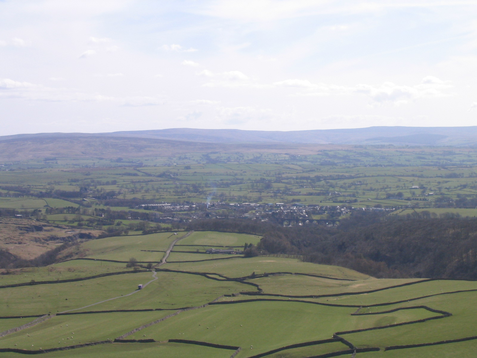
Yew Tree Gorge is a picturesque valley located in the county of Yorkshire, England. Nestled amidst the rolling hills of the Yorkshire Dales National Park, this stunning gorge is renowned for its natural beauty and diverse wildlife.
The gorge is named after the abundant yew trees that line its steep slopes, providing a lush green backdrop to the stunning scenery. These ancient trees, some estimated to be over 1,000 years old, add a sense of history and mystique to the area.
Yew Tree Gorge is carved by a meandering river that flows through its center, creating a series of cascading waterfalls and tranquil pools. The sound of rushing water echoes through the valley, adding to its serene and peaceful atmosphere.
The gorge is a haven for wildlife enthusiasts, as it is home to a variety of species. Visitors may spot red squirrels, badgers, and a wide range of birdlife, including peregrine falcons and kingfishers. The diverse plant life is also a highlight, with rare wildflowers and mosses carpeting the forest floor.
For outdoor enthusiasts, Yew Tree Gorge offers numerous walking trails that wind their way through the valley. These paths provide stunning viewpoints of the surrounding countryside and offer the opportunity to explore the gorge's hidden nooks and crannies.
Yew Tree Gorge is a must-visit destination for those seeking natural beauty and tranquility. Its stunning landscapes, ancient trees, and abundant wildlife make it a true gem within the Yorkshire Dales.
If you have any feedback on the listing, please let us know in the comments section below.
Yew Tree Gorge Images
Images are sourced within 2km of 54.165165/-2.4542047 or Grid Reference SD7074. Thanks to Geograph Open Source API. All images are credited.
![Ingleton features [2] A closer view of the milestone seen in context at <a href="https://www.geograph.org.uk/photo/7031834">SD7073 : Ingleton features [1]</a>.
Erected in the late 19th century. It reads Ingleton ¼ mile; Hawes 16 miles; Lancaster 18 miles; Richmond 40 miles: Listed, grade II, with details at: <span class="nowrap"><a title="https://historicengland.org.uk/listing/the-list/list-entry/1212810" rel="nofollow ugc noopener" href="https://historicengland.org.uk/listing/the-list/list-entry/1212810">Link</a><img style="margin-left:2px;" alt="External link" title="External link - shift click to open in new window" src="https://s1.geograph.org.uk/img/external.png" width="10" height="10"/></span>
Ingleton is a village in North Yorkshire, located at the confluence of the River Doe and the River Twiss which combine to become the River Greta. The village is some 15 miles northeast of Lancaster and some 22 miles northwest of Skipton. First settled in the Iron Age by the Brigantes, the village thrived on coal mining and limestone quarrying. Tourism, mostly from hiking and caving, accounts for most of the economic activity of the village now.](https://s0.geograph.org.uk/geophotos/07/03/18/7031836_bf9c3a49.jpg)
![Ingleton buildings [1] Cross Farm in Hawes Road. Built, probably, in the late 18th century of slobbered stone under a slate roof.
Ingleton is a village in North Yorkshire, located at the confluence of the River Doe and the River Twiss which combine to become the River Greta. The village is some 15 miles northeast of Lancaster and some 22 miles north west of Skipton. First settled in the Iron Age by the Brigantes, the village thrived on coal mining and limestone quarrying. Tourism, mostly from hiking and caving, accounts for most of the economic activity of the village now.](https://s2.geograph.org.uk/geophotos/07/03/18/7031838_c1723ef3.jpg)
![Ingleton houses [1] Pan Well Cottage in Upper Gate was built circa 1670. Constructed of rubble stone with freestone dressings under a stone slate roof. The cottage contains some original roof trusses. Listed, grade II, with details at: <span class="nowrap"><a title="https://historicengland.org.uk/listing/the-list/list-entry/1212912" rel="nofollow ugc noopener" href="https://historicengland.org.uk/listing/the-list/list-entry/1212912">Link</a><img style="margin-left:2px;" alt="External link" title="External link - shift click to open in new window" src="https://s1.geograph.org.uk/img/external.png" width="10" height="10"/></span>
Ingleton is a village in North Yorkshire, located at the confluence of the River Doe and the River Twiss which combine to become the River Greta. The village is some 15 miles northeast of Lancaster and some 22 miles north west of Skipton. First settled in the Iron Age by the Brigantes, the village thrived on coal mining and limestone quarrying. Tourism, mostly from hiking and caving, accounts for most of the economic activity of the village now.](https://s0.geograph.org.uk/geophotos/07/03/18/7031848_9bf6d0e7.jpg)
![Ingleton houses [2] Numbers 1, 2 and 3 Norcot Rise are a row of three cottages in Upper Gate, probably built in the 19th century. Constructed of rubble stone with freestone dressings under a slate roof (numbers 1 and 2) or tile roof (number 3).
Ingleton is a village in North Yorkshire, located at the confluence of the River Doe and the River Twiss which combine to become the River Greta. The village is some 15 miles northeast of Lancaster and some 22 miles northwest of Skipton. First settled in the Iron Age by the Brigantes, the village thrived on coal mining and limestone quarrying. Tourism, mostly from hiking and caving, accounts for most of the economic activity of the village now.](https://s0.geograph.org.uk/geophotos/07/03/18/7031852_19500c0a.jpg)
![Ingleton features [3] At the junction of Upper Gate and High Street is this French style milestone. Erected circa 1994 to commemorate the twinning of Ingleton with the French village of La Chapelle des Marais. There is a closer view of the milestone at <a href="https://www.geograph.org.uk/photo/7031862">SD6973 : Ingleton features [4]</a>.
Ingleton is a village in North Yorkshire, located at the confluence of the River Doe and the River Twiss which combine to become the River Greta. The village is some 15 miles northeast of Lancaster and some 22 miles northwest of Skipton. First settled in the Iron Age by the Brigantes, the village thrived on coal mining and limestone quarrying. Tourism, mostly from hiking and caving, accounts for most of the economic activity of the village now.](https://s0.geograph.org.uk/geophotos/07/03/18/7031860_46b2e080.jpg)
![Ingleton features [4] A closer look at the milestone seen in context at <a href="https://www.geograph.org.uk/photo/7031860">SD6973 : Ingleton features [3]</a>. This French style milestone was erected circa 1994 to commemorate the twinning of Ingleton with the French village of La Chapelle des Marais.
Ingleton is a village in North Yorkshire, located at the confluence of the River Doe and the River Twiss which combine to become the River Greta. The village is some 15 miles northeast of Lancaster and some 22 miles northwest of Skipton. First settled in the Iron Age by the Brigantes, the village thrived on coal mining and limestone quarrying. Tourism, mostly from hiking and caving, accounts for most of the economic activity of the village now.](https://s2.geograph.org.uk/geophotos/07/03/18/7031862_9d47d7a8.jpg)
![Ingleton houses [3] Built as a house in the mid 19th century, this building was converted into a police station with a magistrate&#039;s court, probably in the late 19th century. Now a private residence again. Constructed of snecked limestone with millstone grit dressings under a stone slate roof. Some original internal features remain. Listed, grade II, with details at: <span class="nowrap"><a title="https://historicengland.org.uk/listing/the-list/list-entry/1252723" rel="nofollow ugc noopener" href="https://historicengland.org.uk/listing/the-list/list-entry/1252723">Link</a><img style="margin-left:2px;" alt="External link" title="External link - shift click to open in new window" src="https://s1.geograph.org.uk/img/external.png" width="10" height="10"/></span>
Ingleton is a village in North Yorkshire, located at the confluence of the River Doe and the River Twiss which combine to become the River Greta. The village is some 15 miles northeast of Lancaster and some 22 miles northwest of Skipton. First settled in the Iron Age by the Brigantes, the village thrived on coal mining and limestone quarrying. Tourism, mostly from hiking and caving, accounts for most of the economic activity of the village now.](https://s0.geograph.org.uk/geophotos/07/03/18/7031868_d33a75d0.jpg)
![Ingleton buildings [2] The former barn attached to Green End Farmhouse has been converted into residential accommodation. The building is of rubble stone with freestone dressings under a slate roof. There is a curious, carved stone on the near corner of the building, seen closer at <a href="https://www.geograph.org.uk/photo/7031882">SD6973 : Ingleton buildings [3]</a>.
Ingleton is a village in North Yorkshire, located at the confluence of the River Doe and the River Twiss which combine to become the River Greta. The village is some 15 miles northeast of Lancaster and some 22 miles northwest of Skipton. First settled in the Iron Age by the Brigantes, the village thrived on coal mining and limestone quarrying. Tourism, mostly from hiking and caving, accounts for most of the economic activity of the village now.](https://s3.geograph.org.uk/geophotos/07/03/18/7031879_3a9c0c6a.jpg)
![Ingleton buildings [3] The curious, carved stone on the corner of Green End Farm, seen in context at <a href="https://www.geograph.org.uk/photo/7031879">SD6973 : Ingleton buildings [2]</a>.
Ingleton is a village in North Yorkshire, located at the confluence of the River Doe and the River Twiss which combine to become the River Greta. The village is some 15 miles northeast of Lancaster and some 22 miles northwest of Skipton. First settled in the Iron Age by the Brigantes, the village thrived on coal mining and limestone quarrying. Tourism, mostly from hiking and caving, accounts for most of the economic activity of the village now.](https://s2.geograph.org.uk/geophotos/07/03/18/7031882_5d493576.jpg)
![Ingleton buildings [4] The former Literary Institute in High Street has been converted into flats. Built in 1900 of rubble stone with ashlar dressings under a slate roof.
Ingleton is a village in North Yorkshire, located at the confluence of the River Doe and the River Twiss which combine to become the River Greta. The village is some 15 miles northeast of Lancaster and some 22 miles northwest of Skipton. First settled in the Iron Age by the Brigantes, the village thrived on coal mining and limestone quarrying. Tourism, mostly from hiking and caving, accounts for most of the economic activity of the village now.](https://s1.geograph.org.uk/geophotos/07/03/18/7031893_698dcb9b.jpg)
![Ingleton houses [4] Yanham&#039;s House, High Street, was built circa 1790 and was altered in the 19th century. Constructed of rendered stone under a slate roof. Some original internal features remain. Listed, grade II, with details at: <span class="nowrap"><a title="https://historicengland.org.uk/listing/the-list/list-entry/1262150" rel="nofollow ugc noopener" href="https://historicengland.org.uk/listing/the-list/list-entry/1262150">Link</a><img style="margin-left:2px;" alt="External link" title="External link - shift click to open in new window" src="https://s1.geograph.org.uk/img/external.png" width="10" height="10"/></span>
Ingleton is a village in North Yorkshire, located at the confluence of the River Doe and the River Twiss which combine to become the River Greta. The village is some 15 miles northeast of Lancaster and some 22 miles northwest of Skipton. First settled in the Iron Age by the Brigantes, the village thrived on coal mining and limestone quarrying. Tourism, mostly from hiking and caving, accounts for most of the economic activity of the village now.](https://s1.geograph.org.uk/geophotos/07/03/27/7032705_9d108264.jpg)
![Ingleton houses [5] Originally one house, now two, the oddly named Seed Hill is located in The Square. Built in the mid or late 17th century with alterations in the 18th, 19th and 20th centuries. Constructed of slobbered rubble stone with freestone dressings, all under a stone slate roof. Listed, grade II, with details at: <span class="nowrap"><a title="https://historicengland.org.uk/listing/the-list/list-entry/1262115" rel="nofollow ugc noopener" href="https://historicengland.org.uk/listing/the-list/list-entry/1262115">Link</a><img style="margin-left:2px;" alt="External link" title="External link - shift click to open in new window" src="https://s1.geograph.org.uk/img/external.png" width="10" height="10"/></span>
Ingleton is a village in North Yorkshire, located at the confluence of the River Doe and the River Twiss which combine to become the River Greta. The village is some 15 miles northeast of Lancaster and some 22 miles northwest of Skipton. First settled in the Iron Age by the Brigantes, the village thrived on coal mining and limestone quarrying. Tourism, mostly from hiking and caving, accounts for most of the economic activity of the village now.](https://s2.geograph.org.uk/geophotos/07/03/27/7032706_e16bf277.jpg)
![Ingleton houses [6] A delightful porch on number 4 The Square.
Ingleton is a village in North Yorkshire, located at the confluence of the River Doe and the River Twiss which combine to become the River Greta. The village is some 15 miles northeast of Lancaster and some 22 miles northwest of Skipton. First settled in the Iron Age by the Brigantes, the village thrived on coal mining and limestone quarrying. Tourism, mostly from hiking and caving, accounts for most of the economic activity of the village now.](https://s3.geograph.org.uk/geophotos/07/03/27/7032707_6b376908.jpg)
![Parish church [1] On a site that has held a church since the time of the Normans, stands the Anglican parish church of St Mary. There is a 15th century west tower, the rest of the church was rebuilt in 1887. The tower is constructed of rubble stone, the rest is of snecked and dressed stone under a slate roof. The church contains a Romanesque font. Listed, grade II*, with details at: <span class="nowrap"><a title="https://historicengland.org.uk/listing/the-list/list-entry/1252726" rel="nofollow ugc noopener" href="https://historicengland.org.uk/listing/the-list/list-entry/1252726">Link</a><img style="margin-left:2px;" alt="External link" title="External link - shift click to open in new window" src="https://s1.geograph.org.uk/img/external.png" width="10" height="10"/></span>
Ingleton is a village in North Yorkshire, located at the confluence of the River Doe and the River Twiss which combine to become the River Greta. The village is some 15 miles northeast of Lancaster and some 22 miles northwest of Skipton. First settled in the Iron Age by the Brigantes, the village thrived on coal mining and limestone quarrying. Tourism, mostly from hiking and caving, accounts for most of the economic activity of the village now.](https://s0.geograph.org.uk/geophotos/07/03/27/7032708_e82d4886.jpg)
![Parish church [2] This delightful font was carved around 1150, It was carved out of gritstone found locally and depicts 14 figures representing the life of St Mary. During the reformation the font was rolled into the river, being too fancy for the church. It was pulled out, placed in the tower and used for mixing lime until re-commissioned as a baptismal font in the 19th century.
On a site that has held a church since the time of the Normans, stands the Anglican parish church of St Mary. There is a 15th century west tower, the rest of the church was rebuilt in 1887. The tower is constructed of rubble stone, the rest is of snecked and dressed stone under a slate roof. The church contains a Romanesque font. Listed, grade II*, with details at: <span class="nowrap"><a title="https://historicengland.org.uk/listing/the-list/list-entry/1252726" rel="nofollow ugc noopener" href="https://historicengland.org.uk/listing/the-list/list-entry/1252726">Link</a><img style="margin-left:2px;" alt="External link" title="External link - shift click to open in new window" src="https://s1.geograph.org.uk/img/external.png" width="10" height="10"/></span>
Ingleton is a village in North Yorkshire, located at the confluence of the River Doe and the River Twiss which combine to become the River Greta. The village is some 15 miles northeast of Lancaster and some 22 miles northwest of Skipton. First settled in the Iron Age by the Brigantes, the village thrived on coal mining and limestone quarrying. Tourism, mostly from hiking and caving, accounts for most of the economic activity of the village now.](https://s1.geograph.org.uk/geophotos/07/03/27/7032709_70b14d22.jpg)
![Parish church [3] On a site that has held a church since the time of the Normans, stands the Anglican parish church of St Mary. There is a 15th century west tower, the rest of the church was rebuilt in 1887. The tower is constructed of rubble stone, the rest is of snecked and dressed stone under a slate roof. The church contains a Romanesque font. Listed, grade II*, with details at: <span class="nowrap"><a title="https://historicengland.org.uk/listing/the-list/list-entry/1252726" rel="nofollow ugc noopener" href="https://historicengland.org.uk/listing/the-list/list-entry/1252726">Link</a><img style="margin-left:2px;" alt="External link" title="External link - shift click to open in new window" src="https://s1.geograph.org.uk/img/external.png" width="10" height="10"/></span>
Ingleton is a village in North Yorkshire, located at the confluence of the River Doe and the River Twiss which combine to become the River Greta. The village is some 15 miles northeast of Lancaster and some 22 miles northwest of Skipton. First settled in the Iron Age by the Brigantes, the village thrived on coal mining and limestone quarrying. Tourism, mostly from hiking and caving, accounts for most of the economic activity of the village now.](https://s2.geograph.org.uk/geophotos/07/03/27/7032710_5c2cea15.jpg)
![Parish church [4] The west window, dedicated to the Sherlock family.
On a site that has held a church since the time of the Normans, stands the Anglican parish church of St Mary. There is a 15th century west tower, the rest of the church was rebuilt in 1887. The tower is constructed of rubble stone, the rest is of snecked and dressed stone under a slate roof. The church contains a Romanesque font. Listed, grade II*, with details at: <span class="nowrap"><a title="https://historicengland.org.uk/listing/the-list/list-entry/1252726" rel="nofollow ugc noopener" href="https://historicengland.org.uk/listing/the-list/list-entry/1252726">Link</a><img style="margin-left:2px;" alt="External link" title="External link - shift click to open in new window" src="https://s1.geograph.org.uk/img/external.png" width="10" height="10"/></span>
Ingleton is a village in North Yorkshire, located at the confluence of the River Doe and the River Twiss which combine to become the River Greta. The village is some 15 miles northeast of Lancaster and some 22 miles northwest of Skipton. First settled in the Iron Age by the Brigantes, the village thrived on coal mining and limestone quarrying. Tourism, mostly from hiking and caving, accounts for most of the economic activity of the village now.](https://s3.geograph.org.uk/geophotos/07/03/27/7032711_6ad5ebac.jpg)
Yew Tree Gorge is located at Grid Ref: SD7074 (Lat: 54.165165, Lng: -2.4542047)
Division: West Riding
Administrative County: North Yorkshire
District: Craven
Police Authority: North Yorkshire
What 3 Words
///beats.interrupt.folds. Near Ingleton, North Yorkshire
Nearby Locations
Related Wikis


Nearby Amenities
Located within 500m of 54.165165,-2.4542047Have you been to Yew Tree Gorge?
Leave your review of Yew Tree Gorge below (or comments, questions and feedback).