Anshaw Clough

Valley in Lancashire

England

Anshaw Clough

Trig pillar on Winter Hill The trig pillar on Winter Hill stands at 436 metres above sea level. In the background, the base of the 310 metre high TV mast (to the right) and three of the seven other masts of assorted purpose which crown the hill.
Trig pillar on Winter Hill Credit: Oliver Dixon

Anshaw Clough is a picturesque valley located in the county of Lancashire, England. Situated near the town of Cloughfold, it is a popular destination for nature enthusiasts and hikers who seek a tranquil and scenic setting.

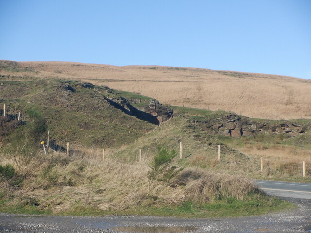
The valley is characterized by its stunning natural beauty, with rolling hills, lush greenery, and a meandering stream that runs through it. The landscape offers breathtaking views, particularly during the spring and summer months when wildflowers dot the hillsides.

Anshaw Clough is home to a diverse range of plant and animal species, making it a haven for wildlife lovers. Visitors may catch a glimpse of various birds, such as peregrine falcons and owls, as well as mammals like deer and foxes. The valley's rich biodiversity is protected and preserved by local conservation efforts.

For outdoor enthusiasts, Anshaw Clough offers an extensive network of walking trails and footpaths that wind through the valley. These trails cater to all levels of fitness and provide an opportunity to explore the area at one's own pace. Additionally, there are designated picnic areas where visitors can relax and enjoy a meal amidst the stunning natural surroundings.

Historically, Anshaw Clough played a significant role in the textile industry during the Industrial Revolution. The valley was home to several mills that produced cotton and woolen goods. Today, remnants of these industrial structures can still be seen, adding to the valley's historical charm.

Overall, Anshaw Clough is a hidden gem in Lancashire, offering visitors a chance to connect with nature, enjoy scenic walks, and immerse themselves in the region's rich history.

If you have any feedback on the listing, please let us know in the comments section below.

Anshaw Clough Images

Images are sourced within 2km of 53.645127/-2.5138527 or Grid Reference SD6616. Thanks to Geograph Open Source API. All images are credited.

Trig pillar on Winter Hill The trig pillar on Winter Hill stands at 436 metres above sea level. In the background, the base of the 310 metre high TV mast (to the right) and three of the seven other masts of assorted purpose which crown the hill.
Trig pillar on Winter Hill
The trig pillar on Winter Hill stands at 436 metres above sea level. In the background, the base of the 310 metre high TV mast (to the right) and three of the seven other masts of assorted purpose which crown the hill.
Road to the aerial masts The road to the westernmost of the aerial masts on Winter Hill is in a pretty poor way. In view, four of the seven smaller masts.
Road to the aerial masts
The road to the westernmost of the aerial masts on Winter Hill is in a pretty poor way. In view, four of the seven smaller masts.
Fence line on the north side of Winter Hill Looking north-west.
Fence line on the north side of Winter Hill
Looking north-west.
Fence line on the north side of Winter Hill Looking east. In view, three of the smaller aerial masts.
Fence line on the north side of Winter Hill
Looking east. In view, three of the smaller aerial masts.
Gatepost and memorial on Winter Hill The plaque on the gatepost commemorates the aircraft crash on Winter Hill on 27th February, 1958 in which 35 members of the motor trade from the Isle of Man died.
Gatepost and memorial on Winter Hill
The plaque on the gatepost commemorates the aircraft crash on Winter Hill on 27th February, 1958 in which 35 members of the motor trade from the Isle of Man died.
Aerial masts on Winter Hill Three of the seven lesser aerial masts on the summit.
Aerial masts on Winter Hill
Three of the seven lesser aerial masts on the summit.
High Street, Belmont
Low Pasture Barn and Winter Hill
Belmont: the turn for Rivington across Winter Hill
Horden Butts Dell Quarry off the Rivington Road.
Horden Butts Dell
Quarry off the Rivington Road.
Rivington Road Descent into Belmont
Rivington Road
Descent into Belmont
Belmont to Rivington Road Descent from the summit at Horden Stoops.
Belmont to Rivington Road
Descent from the summit at Horden Stoops.
Horden Pastures View northwards from Horden Stoops.
Horden Pastures
View northwards from Horden Stoops.
Young plantation, Horden Stoops
Upgraded path, Horden Pastures Southward view towards Winter Hill. The path has been upgraded with long sections of gritstone slabs.
Upgraded path, Horden Pastures
Southward view towards Winter Hill. The path has been upgraded with long sections of gritstone slabs.
Horden Pasture The path along Spitler's Edge has been improved with slabs.
Horden Pasture
The path along Spitler's Edge has been improved with slabs.
Gate, Horden Pasture
Spitler's Edge A boggy moorland ridge. The path has been upgraded with long sections of slabs.
Spitler's Edge
A boggy moorland ridge. The path has been upgraded with long sections of slabs.
Show me another place!

Anshaw Clough is located at Grid Ref: SD6616 (Lat: 53.645127, Lng: -2.5138527)

Unitary Authority: Blackburn with Darwen

Police Authority: Lancashire

What 3 Words

///jokers.goodnight.happening. Near Horwich, Manchester

Nearby Locations

Anshaw Clough

Related Wikis

Spitlers Edge

Spitlers Edge is a ridge running along the eastern edge of Anglezarke Moor, Chorley, Lancashire, England from Standing Stones Hill to Hordern Stoops....

Ward's Reservoir

Ward's Reservoir (or Wards Reservoir), known locally as the Blue Lagoon, is a small reservoir close to the village of Belmont, Lancashire, England. It...

Belmont Reservoir

Belmont Reservoir is a reservoir north of the small moorland village of Belmont, Lancashire, England, fed by the Belmont Brook. It was built in 1826 by...

Belmont, Lancashire

Belmont is a village and former civil parish, now in the parish of North Turton, in the unitary authority area of Blackburn with Darwen, in the ceremonial...

Nearby Amenities

Located within 500m of 53.645127,-2.5138527
The data included in this document is from www.openstreetmap.org. The data is made available under ODbL.

Have you been to Anshaw Clough?

Leave your review of Anshaw Clough below (or comments, questions and feedback).