Ousbydale

Valley in Cumberland Eden

England

Ousbydale

Shepherd's hut showing the fire grate and well-constructed chimney into the stonework marked as a sheepfold on map Second wild camp close to the hut. This time I spent a few hours repairing one wall as it's just too good and remote to let it go to ruin.
Shepherd's hut showing the fire grate and well-constructed chimney into the stonework marked as a sheepfold on map Credit: brian mccaffery

Ousbydale is a picturesque village located in the beautiful Cumberland Valley, in the county of Cumberland, England. Situated in the northern part of the country, this charming community is surrounded by rolling hills, lush green fields, and breathtaking scenery.

The village of Ousbydale is known for its tranquility and peaceful atmosphere. With a population of around 300 residents, it offers a close-knit community where neighbors know each other by name. The village is characterized by its traditional stone cottages and well-maintained gardens, giving it a timeless and idyllic appearance.

Despite its small size, Ousbydale boasts several amenities for its residents. The village has a local pub, The Cumberland Arms, which serves as a gathering place for locals and visitors alike. Additionally, there is a community hall that hosts various events throughout the year, fostering a sense of community spirit.

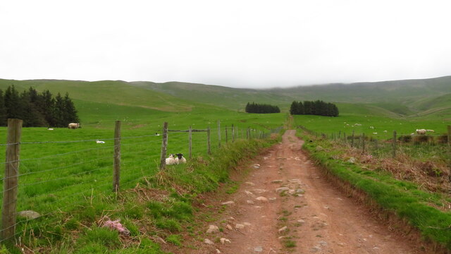
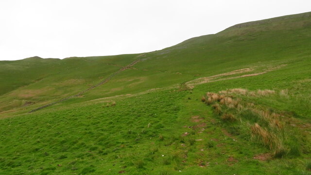
Nature enthusiasts will find plenty to enjoy in Ousbydale. The village is surrounded by stunning countryside, perfect for leisurely walks and outdoor activities. The nearby Ousby Forest offers a peaceful retreat for those seeking a break from the hustle and bustle of daily life.

Ousbydale is well-connected to the rest of the region. The village is located just off the A686 road, which provides easy access to nearby towns and cities. The closest larger town, Penrith, is approximately 10 miles away and offers a wider range of amenities, including shops, schools, and healthcare facilities.

In conclusion, Ousbydale is a charming village nestled in the picturesque Cumberland Valley. With its stunning natural surroundings, tight-knit community, and convenient location, it offers a peaceful and idyllic place to call home.

If you have any feedback on the listing, please let us know in the comments section below.

Ousbydale Images

Images are sourced within 2km of 54.721658/-2.5467125 or Grid Reference NY6436. Thanks to Geograph Open Source API. All images are credited.

Shepherd's hut showing the fire grate and well-constructed chimney into the stonework marked as a sheepfold on map Second wild camp close to the hut. This time I spent a few hours repairing one wall as it's just too good and remote to let it go to ruin.
Shepherd's hut showing the fire grate and well-constructed chimney into the stonework marked as a sheepfold on map
Second wild camp close to the hut. This time I spent a few hours repairing one wall as it's just too good and remote to let it go to ruin.
Shepherd's hut marked on map as a sheepfold Few hours' repairing one side. Probably constructed purely for an overnight stay to escape the harsh elements, complete with a fireplace/metal grate and  chimney. Roof was constructed out of a tree trunk for the joist and branches for the purlins, then corrugated sheeting covered it.
Shepherd's hut marked on map as a sheepfold
Few hours' repairing one side. Probably constructed purely for an overnight stay to escape the harsh elements, complete with a fireplace/metal grate and chimney. Roof was constructed out of a tree trunk for the joist and branches for the purlins, then corrugated sheeting covered it.
Shepherd's hut. Spent an hour rebuilding another section.
Shepherd's hut.
Spent an hour rebuilding another section.
Heading NE on track at Little Awfell above Melmerby
Hill track ascending above Meikle Awfell above Melmerby
Summit cairn on Melmerby Fell
Maiden Way (Roman Road) leading up to Meg's Cairn on Melmerby Fell
Climbing out of Ardale On the track above the lime kiln which leads to the Maiden Way and the high fells. A narrow gauge railway once ran down this way. Across the Eden Valley are the northern fells of the Lake District.
Climbing out of Ardale
On the track above the lime kiln which leads to the Maiden Way and the high fells. A narrow gauge railway once ran down this way. Across the Eden Valley are the northern fells of the Lake District.
Track (dismantled railway) on Ladslack Hill One of the rails of this old narrow gauge railway is visible in the foreground. It may have carried limestone down to the big lime kiln in Ardale <a title="https://www.geograph.org.uk/photo/2768869" href="https://www.geograph.org.uk/photo/2768869">Link</a> Across the Eden Valley are the Lakeland fells.
Track (dismantled railway) on Ladslack Hill
One of the rails of this old narrow gauge railway is visible in the foreground. It may have carried limestone down to the big lime kiln in Ardale Link Across the Eden Valley are the Lakeland fells.
Rusby Hill (352m) A minor top on the west flank of the North Pennines above Ousby.
Rusby Hill (352m)
A minor top on the west flank of the North Pennines above Ousby.
Ruined lime kiln and sheep by the Maiden Way After a steep haul out of the valley the track levels off where there are signs of limestone quarrying. The flat top of Cross Fell visible beyond.
Ruined lime kiln and sheep by the Maiden Way
After a steep haul out of the valley the track levels off where there are signs of limestone quarrying. The flat top of Cross Fell visible beyond.
Muska Hill (536m) from the Maiden Way The next bump down is Sharp Shears (487m) with the northern fells of the Lake District across the misty Eden Valley beyond.
Muska Hill (536m) from the Maiden Way
The next bump down is Sharp Shears (487m) with the northern fells of the Lake District across the misty Eden Valley beyond.
A cairn by the Maiden Way Small but perfectly formed. Cuns Fell (539m) is the conspicuously rugged height across Ousbydale.
A cairn by the Maiden Way
Small but perfectly formed. Cuns Fell (539m) is the conspicuously rugged height across Ousbydale.
Cuns Fell (539m) Seen across Ousbydale from the Maiden Way. There are quite a few rounded or peaked summits along the East Fellside (the section of the North Pennines rising above the Eden Valley). Probably the best known are the "pikes" such as Dufton, Knock and Murton. They are formed from different rocks to the more usual sandstones, shales and limestones of the nearby Pennine escarpment. Some are probably volcanic in origin or igneous like the dolerite that rings High Cup and which outcrops all along this part of the fells.
Cuns Fell (539m)
Seen across Ousbydale from the Maiden Way. There are quite a few rounded or peaked summits along the East Fellside (the section of the North Pennines rising above the Eden Valley). Probably the best known are the "pikes" such as Dufton, Knock and Murton. They are formed from different rocks to the more usual sandstones, shales and limestones of the nearby Pennine escarpment. Some are probably volcanic in origin or igneous like the dolerite that rings High Cup and which outcrops all along this part of the fells.
Wall above Ousbydale Crossed on the Maiden way. Beyond is Muska Hill and the curiously named top of Sharp Shears separated by Windy Gap. Across the misty Eden Valley are the much busier Lakeland fells.
Wall above Ousbydale
Crossed on the Maiden way. Beyond is Muska Hill and the curiously named top of Sharp Shears separated by Windy Gap. Across the misty Eden Valley are the much busier Lakeland fells.
Upright stone, Maiden Way on Melmerby Fell We saw no markings on the stone but its location near the old bridleway (and Roman Road) suggests it was a marker for the route in poor weather. No need today with Cross Fell in clear view across the moorland miles.
Upright stone, Maiden Way on Melmerby Fell
We saw no markings on the stone but its location near the old bridleway (and Roman Road) suggests it was a marker for the route in poor weather. No need today with Cross Fell in clear view across the moorland miles.
Stone by the Maiden Way This large, tapering stone just beside the track may have been a route marker when, of course it would have stood upright. There are signs of straight cuts and pittings which could conceivably be prehistoric (or just chisel marks and natural weathering). The view is towards Cuns Fell and the distant northern fells of Lakeland.
Stone by the Maiden Way
This large, tapering stone just beside the track may have been a route marker when, of course it would have stood upright. There are signs of straight cuts and pittings which could conceivably be prehistoric (or just chisel marks and natural weathering). The view is towards Cuns Fell and the distant northern fells of Lakeland.
Small tarn near the Maiden Way on Melmerby Fell The upright slab of gritstone may be a marker (similar to <a title="https://www.geograph.org.uk/photo/2770101)" href="https://www.geograph.org.uk/photo/2770101)">Link</a> - but if so, why is it here and not by the track?
Small tarn near the Maiden Way on Melmerby Fell
The upright slab of gritstone may be a marker (similar to Link - but if so, why is it here and not by the track?
Show me another place!

Ousbydale is located at Grid Ref: NY6436 (Lat: 54.721658, Lng: -2.5467125)

Administrative County: Cumbria

District: Eden

Police Authority: Cumbria

What 3 Words

///abandons.tasks.earth. Near Alston, Cumbria

Nearby Locations

Cuns Fell Ousbydale

Related Wikis

Ousby

Ousby is a village and civil parish in Eden district, in the English county of Cumbria. It is a Thankful Village, one of 52 parishes in England and Wales...

Melmerby, Cumbria

Melmerby is a village and civil parish in the Eden district, in the county of Cumbria, England. It is a small village with a population of around 200....

Kirkland, Culgaith

Kirkland is a village in the Eden district of the English county of Cumbria. It is in the historic county of Cumberland. There is a fell called Kirkland...

Cross Fell

Cross Fell is the highest mountain in the Pennines of Northern England and the highest point in England outside the Lake District. It is located in the...

St John's Church, Gamblesby

St. John's Church was a Victorian parish Church of England church in the village of Gamblesby, Cumbria, England.The Gothic Revival-style church, with tall...

Gamblesby

Gamblesby is a village near Melmerby, and former civil parish, now in the parish of Glassonby, in the Westmorland and Furness district, in the ceremonial...

Skirwith

Skirwith is a village and former civil parish, now in the parish of Culgaith, in the Eden district, in the county of Cumbria, England. In 1931 the parish...

Blencarn

Blencarn is a small village located in the Eden District of Cumbria, England. The village is situated at the foot of the Pennines. In Blencarn there is...

Nearby Amenities

Located within 500m of 54.721658,-2.5467125
Cuns Fell
Ele: 535.2
Natural: peak
Source: NPE
Lat/Long: 54.7249052/-2.5484152
Ford: yes
Lat/Long: 54.7209459/-2.5453077
Ford: yes
Lat/Long: 54.7197758/-2.5462099
Ford: yes
Lat/Long: 54.718766/-2.5483796
Ford: yes
Lat/Long: 54.718484/-2.5484725
Ousbydale
Place: locality
Lat/Long: 54.7223476/-2.5432276
The data included in this document is from www.openstreetmap.org. The data is made available under ODbL.

Have you been to Ousbydale?

Leave your review of Ousbydale below (or comments, questions and feedback).