Green Pot Clough

Valley in Yorkshire Ribble Valley

England

Green Pot Clough

Looking up Fox Clough
Looking up Fox Clough Credit: shikari

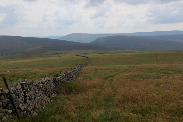
Green Pot Clough is a picturesque valley located in Yorkshire, England. Situated amidst the stunning natural beauty of the Yorkshire Dales, the clough is known for its lush green landscape, rugged terrain, and tranquil atmosphere. It is a popular destination for nature lovers, hikers, and photographers alike.

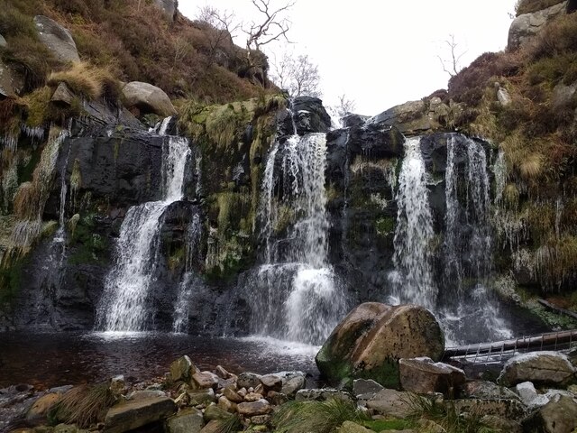
The valley is characterized by its steep slopes, rocky outcrops, and cascading waterfalls. The sound of rushing water can be heard throughout the clough as streams and rivers meander through the landscape, creating a soothing ambiance. The vegetation in Green Pot Clough is abundant and diverse, with a variety of trees, plants, and wildflowers adorning the valley.

The clough offers numerous hiking trails, ranging from easy walks to more challenging routes, catering to all levels of fitness and experience. The paths wind their way through the valley, providing breathtaking views at every turn. One of the highlights of Green Pot Clough is the presence of several picturesque waterfalls, which add to the allure of the area.

Wildlife enthusiasts will also find Green Pot Clough to be a haven for various animal species. The valley is home to a range of birdlife, including buzzards, kestrels, and peregrine falcons, making it a great spot for birdwatching. Additionally, visitors may spot rabbits, foxes, and even deer roaming freely in the surrounding fields.

With its natural beauty, diverse flora and fauna, and peaceful ambiance, Green Pot Clough offers a serene escape from the hustle and bustle of everyday life. It is an idyllic destination for those seeking a connection with nature and a place to unwind and recharge in the heart of Yorkshire.

If you have any feedback on the listing, please let us know in the comments section below.

Green Pot Clough Images

Images are sourced within 2km of 54.007985/-2.5576964 or Grid Reference SD6357. Thanks to Geograph Open Source API. All images are credited.

Looking up Fox Clough
Looking upstream up the Brennand river, upstream of the intake
Tiny pool/waterfall in the Brennand river
Looking downstream on the Brennand river
Looking upstream at a set of tiny waterfalls on the Brennand river
Looking upstream on the Brennand river
Larger waterfall on the Brennand river
Waterfall on the Brennand river
Shooting hut on Tooth Hill as seen from the south side of Brennand Round Hill
View from Wolfhole Crag across to the Three Peaks
Summit of Brennand Great Hill A faint grassy track and dry stone boundary wall cross over the summit at 1,555 ft above sea level.
Summit of Brennand Great Hill
A faint grassy track and dry stone boundary wall cross over the summit at 1,555 ft above sea level.
Elephant Rock Gritstone boulder on Brennand Great Hill - shaped like an elephant's head.
Elephant Rock
Gritstone boulder on Brennand Great Hill - shaped like an elephant's head.
Approaching Woodyards Soggy landscape of peat, bog and haggs
Approaching Woodyards
Soggy landscape of peat, bog and haggs
Descending off Brennand Great Hill Following the boundary wall towards Millers House
Descending off Brennand Great Hill
Following the boundary wall towards Millers House
Looking North from Brennand Great Hill Looking over a stark landscape of naked peat, bog and tundra moor.
There are a huge number of seagulls of varied assortments that congregate around this location, known as "The Gullery". Apparently over 50,000 arrive around springtime to breed, making a mess that is all too obvious.
They are protected, I believe, although they discourage more native birds like curlew and lapwing from thriving through theft of eggs and chicks.
If you are thinking of stopping to have a sandwich between Brennand Great Hill and Wolfhole Crag - perhaps think again.
Looking North from Brennand Great Hill
Looking over a stark landscape of naked peat, bog and tundra moor. There are a huge number of seagulls of varied assortments that congregate around this location, known as "The Gullery". Apparently over 50,000 arrive around springtime to breed, making a mess that is all too obvious. They are protected, I believe, although they discourage more native birds like curlew and lapwing from thriving through theft of eggs and chicks. If you are thinking of stopping to have a sandwich between Brennand Great Hill and Wolfhole Crag - perhaps think again.
Looking North West from Brennand Great Hill
View on a very misty day at Wolfhole Crag Triangulation Pillar Looking eastward.
View on a very misty day at Wolfhole Crag Triangulation Pillar
Looking eastward.
Wolfhole Crag View of Wolfhole Crag.
Wolfhole Crag
View of Wolfhole Crag.
Show me another place!

Green Pot Clough is located at Grid Ref: SD6357 (Lat: 54.007985, Lng: -2.5576964)

Division: West Riding

Administrative County: Lancashire

District: Ribble Valley

Police Authority: Lancashire

What 3 Words

///hype.bulky.rush. Near High Bentham, North Yorkshire

Related Wikis

Brennand Farm

Brennand Farm is often claimed to be the true centre of Great Britain. This is about seven kilometres north-west of Dunsop Bridge - which has the nearest...

Wolfhole Crag

Wolfhole Crag is an isolated and seldom-visited hill in the Forest of Bowland in Lancashire, England. Its seclusion is due in part to its low profile and...

Geography of the United Kingdom

The United Kingdom is a sovereign state located off the north-western coast of continental Europe. With a total area of approximately 248,532 square kilometres...

White Hill (Forest of Bowland)

White Hill is a hill in the Forest of Bowland, north-western England. It lies between Slaidburn and High Bentham. The summit houses a tower and a trig...

Nearby Amenities

Located within 500m of 54.007985,-2.5576964
Brown Syke Hill
Natural: peak
Lat/Long: 54.0081253/-2.5535913
The data included in this document is from www.openstreetmap.org. The data is made available under ODbL.

Have you been to Green Pot Clough?

Leave your review of Green Pot Clough below (or comments, questions and feedback).