Dure Clough
Valley in Yorkshire Ribble Valley
England
Dure Clough

Dure Clough is a picturesque valley located in the county of Yorkshire, England. Nestled within the rugged landscape of the Pennines, it is renowned for its natural beauty and tranquil atmosphere. The valley stretches for approximately 2 miles, encompassing a diverse range of landscapes and habitats.
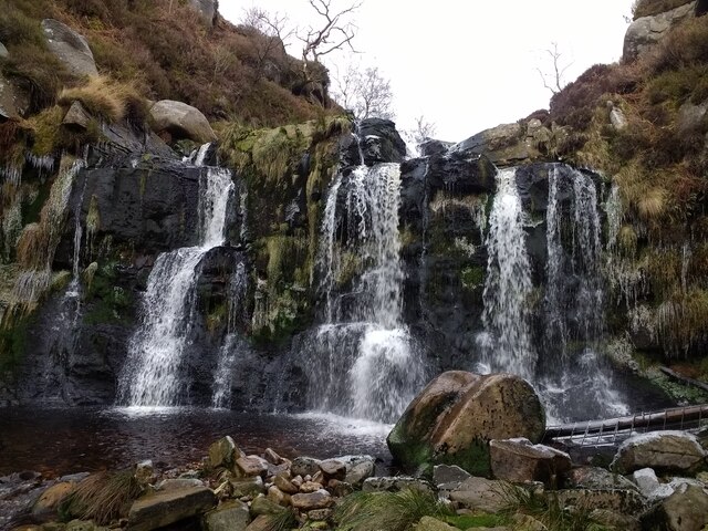
The centerpiece of Dure Clough is the meandering river, which flows through the valley, providing a source of life and beauty to the surrounding area. The river is flanked by lush green meadows, dotted with wildflowers during the warmer months. The gentle babbling of the water creates a soothing soundtrack for visitors and local wildlife alike.
The surrounding hills and slopes are covered in dense woodlands, consisting primarily of native oak and birch trees. These woodlands provide a haven for a variety of bird species, including the elusive tawny owl and the vibrant kingfisher. The valley also supports a diverse range of plant life, with bluebells, primroses, and foxgloves adorning the forest floor.
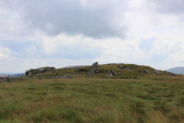
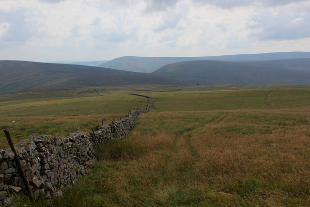
For outdoor enthusiasts, Dure Clough offers numerous hiking trails that wind through the valley, providing breathtaking views of the surrounding countryside. The trails vary in difficulty, catering to both novice walkers and experienced hikers. Along the way, visitors may encounter ancient stone walls and remnants of old mining activities, offering glimpses into the valley's rich history.
Dure Clough truly embodies the natural beauty and charm of Yorkshire, making it a must-visit destination for nature lovers and those seeking a peaceful retreat in the heart of the countryside.
If you have any feedback on the listing, please let us know in the comments section below.
Dure Clough Images
Images are sourced within 2km of 54.007853/-2.5609904 or Grid Reference SD6357. Thanks to Geograph Open Source API. All images are credited.


Dure Clough is located at Grid Ref: SD6357 (Lat: 54.007853, Lng: -2.5609904)
Division: West Riding
Administrative County: Lancashire
District: Ribble Valley
Police Authority: Lancashire
What 3 Words
///revolting.monk.merge. Near High Bentham, North Yorkshire
Nearby Locations
Related Wikis

Brennand Farm
Brennand Farm is often claimed to be the true centre of Great Britain. This is about seven kilometres north-west of Dunsop Bridge - which has the nearest...

Wolfhole Crag
Wolfhole Crag is a lonely and seldom-visited hill in the Forest of Bowland in Lancashire, England. Its seclusion is due in part to its low profile and...

Geography of the United Kingdom
The United Kingdom is a sovereign state located off the north-western coast of continental Europe. With a total area of approximately 248,532 square kilometres...

Grey Stone of Trough
The Grey Stone of Trough is an historic boundary marker in Bowland Forest High, in the Trough of Bowland, Lancashire, England. A Grade II listed structure...

White Hill (Forest of Bowland)
White Hill is a hill in the Forest of Bowland, north-western England. It lies between Slaidburn and High Bentham. The summit houses a tower and a trig...

Trough of Bowland
The Trough of Bowland is a valley and high pass in the Forest of Bowland Area of Outstanding Natural Beauty, Lancashire, England. The pass, reaching 968...

Ward's Stone
Ward's Stone is the highest hill in the Forest of Bowland, England. Its flat top hides two trig points nearly a kilometre apart. The western trig point...

Sykes Smelt Mill
Sykes Smelt Mill was a mediaeval mill located between Sykes and Hareden in Bowland Forest High, Lancashire, England. It stood on the banks of Langden Brook...
Nearby Amenities
Located within 500m of 54.007853,-2.5609904Have you been to Dure Clough?
Leave your review of Dure Clough below (or comments, questions and feedback).