Cannerheugh Gill

Valley in Cumberland Eden

England

Cannerheugh Gill

Domed Field with cattle The field lies south-east of the village of Unthank and south of a tree-lined stream, probably named Limekiln Beck.
Domed Field with cattle Credit: Trevor Littlewood

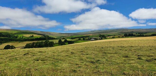
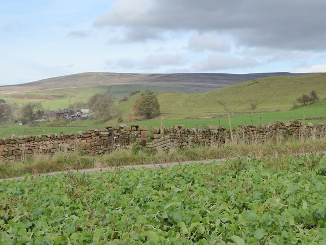
Cannerheugh Gill is a picturesque valley located in the county of Cumberland, England. Nestled amidst the rolling hills and lush greenery, this tranquil gill offers breathtaking views and an abundance of natural beauty.

The valley is characterized by its steep-sided slopes, which are carved out by the Cannerheugh Beck, a small stream that flows through the region. The beck cascades down from the higher ground, creating a series of stunning waterfalls and pools along its course. These water features, surrounded by moss-covered rocks and ferns, add to the charm and serenity of the gill.

The valley is home to a diverse range of flora and fauna. The dense woodlands that line the slopes are filled with a variety of trees, including oak, beech, and ash. This provides a habitat for numerous bird species, such as the pied flycatcher and wood warbler, as well as smaller animals like squirrels and badgers.

For outdoor enthusiasts, Cannerheugh Gill offers excellent opportunities for hiking and exploring. A network of footpaths and trails crisscrosses the valley, allowing visitors to discover its hidden gems and enjoy its tranquility. The gill is particularly popular in the spring, when the woods come alive with vibrant wildflowers and the sound of birdsong fills the air.

Overall, Cannerheugh Gill is a natural paradise that showcases the beauty of the Cumberland countryside. Its enchanting waterfalls, verdant woodlands, and diverse wildlife make it a must-visit destination for nature lovers and those seeking a peaceful escape from the hustle and bustle of everyday life.

If you have any feedback on the listing, please let us know in the comments section below.

Cannerheugh Gill Images

Images are sourced within 2km of 54.7694/-2.5898366 or Grid Reference NY6241. Thanks to Geograph Open Source API. All images are credited.

Domed Field with cattle The field lies south-east of the village of Unthank and south of a tree-lined stream, probably named Limekiln Beck.
Domed Field with cattle
The field lies south-east of the village of Unthank and south of a tree-lined stream, probably named Limekiln Beck.
Haresceugh View looking towards Haresceugh and the Pennines.
Haresceugh
View looking towards Haresceugh and the Pennines.
Old Milestone by the A686, north east of Melmerby Carved stone post by the A686, in parish of OUSBY (EDEN District), Melmerby, Long Craggs, on bend, in banking, opposite Snow pole, on East side of road. Alston stone, erected by the Alston turnpike trust in the 19th century. 

Inscription reads:-
ALSTON
8
PENRITH
11 
Carved benchmark on front top.

Milestone Society National ID: CU_ALPR08.
Old Milestone by the A686, north east of Melmerby
Carved stone post by the A686, in parish of OUSBY (EDEN District), Melmerby, Long Craggs, on bend, in banking, opposite Snow pole, on East side of road. Alston stone, erected by the Alston turnpike trust in the 19th century. Inscription reads:- ALSTON 8 PENRITH 11 Carved benchmark on front top. Milestone Society National ID: CU_ALPR08.
Direction Sign - Signpost opposite the Renwick turn off Located on the east side of the junction of the A686 and the minor road to Renwick in Kirkoswald parish. 3 arms and pawn finial

Milestone Society National ID: CU_NY6341
Direction Sign - Signpost opposite the Renwick turn off
Located on the east side of the junction of the A686 and the minor road to Renwick in Kirkoswald parish. 3 arms and pawn finial Milestone Society National ID: CU_NY6341
Heading down into the vale A view down the minor road which drops downhill from off the A686 towards Unthank and Gamblesby. The tree lined road contrasts with the open hillsides above, whilst this photo is very close to where the carboniferous rocks of the north Pennines give way to the younger sandstones of the Vale of Eden.
Heading down into the vale
A view down the minor road which drops downhill from off the A686 towards Unthank and Gamblesby. The tree lined road contrasts with the open hillsides above, whilst this photo is very close to where the carboniferous rocks of the north Pennines give way to the younger sandstones of the Vale of Eden.
Looking west on the A686
The A686 at the Renwick turnoff
Footpath leading to Hazel Rigg
View from Hartside as power lines enter the fog
A686 descending below Green Fell, but above the fog
A686 descends in fog, north of Sailrigg Quarry
Road below Hartside Summit
House in Unthank The noticeboard for this tiny village is on the wall.
House in Unthank
The noticeboard for this tiny village is on the wall.
Footbridge over Eller Beck
Where's the path? (1) From this stile, this public footpath near Cannerheugh Farm crosses the field diagonally. Except that the way is totally overgrown by a root crop which makes for very hard walking.
Where's the path? (1)
From this stile, this public footpath near Cannerheugh Farm crosses the field diagonally. Except that the way is totally overgrown by a root crop which makes for very hard walking.
Where's the path? (2) The line of this public footpath near Cannerheugh Farm crosses the field diagonally, but has been  totally overgrown by a root crop which makes for very hard walking.
Where's the path? (2)
The line of this public footpath near Cannerheugh Farm crosses the field diagonally, but has been totally overgrown by a root crop which makes for very hard walking.
Where's the path? (3) The line of this public footpath near Cannerheugh Farm crosses the field diagonally, but has been totally overgrown by a root crop which makes for very hard walking. But at last the end is in sight with a stile through to the next, mercifully easier, field.

Thack Moor <a href="https://www.geograph.org.uk/gridref/NY6146">NY6146</a> on the skyline.
Where's the path? (3)
The line of this public footpath near Cannerheugh Farm crosses the field diagonally, but has been totally overgrown by a root crop which makes for very hard walking. But at last the end is in sight with a stile through to the next, mercifully easier, field. Thack Moor NY6146 on the skyline.
Barns at Busk A tiny three-house hamlet.
Barns at Busk
A tiny three-house hamlet.
Show me another place!

Cannerheugh Gill is located at Grid Ref: NY6241 (Lat: 54.7694, Lng: -2.5898366)

Administrative County: Cumbria

District: Eden

Police Authority: Cumbria

What 3 Words

///weaved.ulterior.licks. Near Alston, Cumbria

Related Wikis

Busk, Cumbria

Busk is a hamlet in Cumbria, England. It is located 3.7 miles (6.0 km) by road to the east of Kirkoswald. == See also == List of places in Cumbria ��2...

Unthank, Glassonby

Unthank is a village near Gamblesby in the civil parish of Glassonby in Cumbria, England. It is first mentioned in writing as Unthanke in 1332. == See... ==

Gamblesby

Gamblesby is a village near Melmerby, and former civil parish, now in the parish of Glassonby, in the Westmorland and Furness district, in the ceremonial...

St John's Church, Gamblesby

St. John's Church was a Victorian parish Church of England church in the village of Gamblesby, Cumbria, England.The Gothic Revival-style church, with tall...

Renwick, Cumbria

Renwick, formerly known as Ravenwick, is a small village and former civil parish, now in the parish of Kirkoswald, in the Eden district, in the county...

Black Fell (Pennines)

Black Fell is a hill in the North Pennines, England. It is located just north of the A686 road, west of Alston and is one of the most northerly parts of...

Melmerby, Cumbria

Melmerby is a village and civil parish in the Eden district, in the county of Cumbria, England. It is a small village with a population of around 200....

Glassonby

Glassonby is a small village and civil parish in the Eden Valley of Cumbria, England, about 3 miles (4.8 km) south south east of Kirkoswald. At the 2001...

Nearby Amenities

Located within 500m of 54.7694,-2.5898366
Power: pole
Lat/Long: 54.7655492/-2.5927922
Power: pole
Lat/Long: 54.7656938/-2.5916378
Power: pole
Lat/Long: 54.765855/-2.5904794
Power: pole
Lat/Long: 54.7660564/-2.5887869
Power: pole
Lat/Long: 54.7661548/-2.5877845
Power: pole
Lat/Long: 54.7662709/-2.5868171
Power: pole
Lat/Long: 54.7664356/-2.5853669
Power: pole
Lat/Long: 54.7669558/-2.5832955
Power: pole
Lat/Long: 54.7667745/-2.5848565
Power: pole
Lat/Long: 54.7666205/-2.5862471
Power: pole
Lat/Long: 54.766451/-2.5877013
Power: pole
Lat/Long: 54.7662946/-2.5890405
Power: pole
Lat/Long: 54.7660908/-2.5908173
Power: pole
Lat/Long: 54.7653027/-2.5920189
The data included in this document is from www.openstreetmap.org. The data is made available under ODbL.

Have you been to Cannerheugh Gill?

Leave your review of Cannerheugh Gill below (or comments, questions and feedback).