Bushy Combe

Valley in Somerset Mendip

England

Bushy Combe

View from Amy's Picnic Area on NCN3 near Glastonbury Looking east towards Glastonbury Tor from Amy's Picnic Area on the NCN3 path near Glastonbury.
Amy's Picnic Area was built in memory of a local teenager who tragically died of an asthma attack - for information please see <span class="nowrap"><a title="https://amy-thomas.muchloved.com/Lifestories/39617904" rel="nofollow ugc noopener" href="https://amy-thomas.muchloved.com/Lifestories/39617904">Link</a><img style="margin-left:2px;" alt="External link" title="External link - shift click to open in new window" src="https://s1.geograph.org.uk/img/external.png" width="10" height="10"/></span>
View from Amy's Picnic Area on NCN3 near Glastonbury Credit: Kevin Pearson

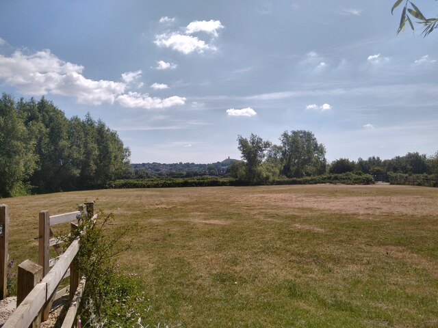
Bushy Combe is a picturesque valley located in Somerset, England. Nestled amidst the rolling hills of the West Country, it is renowned for its breathtaking natural beauty and tranquil ambiance. The valley is situated in close proximity to the village of Winsford, adding to its charm and accessibility.

The landscape of Bushy Combe is characterized by lush green meadows, dense woodlands, and meandering streams that flow through the valley. It is home to a diverse range of flora and fauna, making it a haven for nature enthusiasts and wildlife lovers. The area is particularly known for its vibrant display of wildflowers during the spring and summer months.

The valley offers a plethora of recreational activities for visitors to enjoy. Hiking and walking trails crisscross the area, providing opportunities to explore the enchanting countryside and take in panoramic views of the surrounding hills. The tranquil streams are ideal for fishing, while the woodlands provide ample space for camping and picnicking.

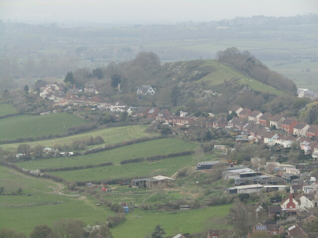
Bushy Combe has a rich historical heritage as well. There are several ancient ruins and archaeological sites scattered throughout the valley, including the remnants of old settlements and medieval structures. These remnants serve as a testament to the valley's long and fascinating history.

Overall, Bushy Combe is a hidden gem in Somerset, offering a peaceful retreat from the hustle and bustle of city life. Its natural beauty, recreational activities, and historical significance make it a must-visit destination for anyone seeking solace in the heart of the English countryside.

If you have any feedback on the listing, please let us know in the comments section below.

Bushy Combe Images

Images are sourced within 2km of 51.148226/-2.7060655 or Grid Reference ST5039. Thanks to Geograph Open Source API. All images are credited.

View from Amy's Picnic Area on NCN3 near Glastonbury Looking east towards Glastonbury Tor from Amy's Picnic Area on the NCN3 path near Glastonbury.
Amy's Picnic Area was built in memory of a local teenager who tragically died of an asthma attack - for information please see <span class="nowrap"><a title="https://amy-thomas.muchloved.com/Lifestories/39617904" rel="nofollow ugc noopener" href="https://amy-thomas.muchloved.com/Lifestories/39617904">Link</a><img style="margin-left:2px;" alt="External link" title="External link - shift click to open in new window" src="https://s1.geograph.org.uk/img/external.png" width="10" height="10"/></span>
View from Amy's Picnic Area on NCN3 near Glastonbury
Looking east towards Glastonbury Tor from Amy's Picnic Area on the NCN3 path near Glastonbury. Amy's Picnic Area was built in memory of a local teenager who tragically died of an asthma attack - for information please see LinkExternal link
Glastonbury - Market Cross The Victorian Gothic (1846) cross replaces its medieval octagonal predecessor and was designed on Waltham Cross in London by Sir Benjamin Ferry.
In the background is The Crown.
Glastonbury - Market Cross
The Victorian Gothic (1846) cross replaces its medieval octagonal predecessor and was designed on Waltham Cross in London by Sir Benjamin Ferry. In the background is The Crown.
Glastonbury - Market Place A busy and colourful corner of Glastonbury.
The "Mendip Explorer" bus is operated by First Mendip and connects Bristol with Street.
Glastonbury - Market Place
A busy and colourful corner of Glastonbury. The "Mendip Explorer" bus is operated by First Mendip and connects Bristol with Street.
Glastonbury - High Street Shopping Shop windows - flower power is still alive and well in Glastonbury.
Glastonbury - High Street Shopping
Shop windows - flower power is still alive and well in Glastonbury.
Glastonbury - The George & Pilgrim's Inn Reputedly Europe's best preserved medieval inn, it was rebuilt ca 1455-75 to house abbey visitors. The old inn on the High Street is now a hotel.
Glastonbury - The George & Pilgrim's Inn
Reputedly Europe's best preserved medieval inn, it was rebuilt ca 1455-75 to house abbey visitors. The old inn on the High Street is now a hotel.
Glastonbury - Mural "Glastonbury Experience" by Jon Minshull - one of several artworks on the Glastonbury Mural Trail.
<span class="nowrap"><a title="www.glastonbury.gov.uk" rel="nofollow ugc noopener" href="http://www.glastonbury.gov.uk">Link</a><img style="margin-left:2px;" alt="External link" title="External link - shift click to open in new window" src="https://s1.geograph.org.uk/img/external.png" width="10" height="10"/></span>
Glastonbury - Mural
"Glastonbury Experience" by Jon Minshull - one of several artworks on the Glastonbury Mural Trail. LinkExternal link
Glastonbury - High Street Glastonbury Tribunal is a historic building dating back to the late 15th century.
<span class="nowrap"><a title="www.glastonbury.gov.uk" rel="nofollow ugc noopener" href="http://www.glastonbury.gov.uk">Link</a><img style="margin-left:2px;" alt="External link" title="External link - shift click to open in new window" src="https://s1.geograph.org.uk/img/external.png" width="10" height="10"/></span>
Glastonbury - High Street
Glastonbury Tribunal is a historic building dating back to the late 15th century. LinkExternal link
Glastonbury - The Goddess and The Green Man A colourful facade and alternative shopping on the High Street.
<span class="nowrap"><a title="www.glastonbury.gov.uk" rel="nofollow ugc noopener" href="http://www.glastonbury.gov.uk">Link</a><img style="margin-left:2px;" alt="External link" title="External link - shift click to open in new window" src="https://s1.geograph.org.uk/img/external.png" width="10" height="10"/></span>
Glastonbury - The Goddess and The Green Man
A colourful facade and alternative shopping on the High Street. LinkExternal link
Glastonbury - The Goddess Rainbow's End Cafe meets The Goddess - esoteric shops on Glastonbury's High Street.
<span class="nowrap"><a title="www.glastonbury.gov.uk" rel="nofollow ugc noopener" href="http://www.glastonbury.gov.uk">Link</a><img style="margin-left:2px;" alt="External link" title="External link - shift click to open in new window" src="https://s1.geograph.org.uk/img/external.png" width="10" height="10"/></span>
Glastonbury - The Goddess
Rainbow's End Cafe meets The Goddess - esoteric shops on Glastonbury's High Street. LinkExternal link
Glastonbury - Wearyall Hill Seen here from the summit of Glastonbury Tor. These hills were prehistoric islands within the "Avalon Marshes" when sea levels were higher.
Pilgrims allegedly trudged over this hill as they approached Glastonbury Abbey from the southwest.
Glastonbury - Wearyall Hill
Seen here from the summit of Glastonbury Tor. These hills were prehistoric islands within the "Avalon Marshes" when sea levels were higher. Pilgrims allegedly trudged over this hill as they approached Glastonbury Abbey from the southwest.
Glastonbury - Mural Trail "Globe Inn" by Oksana Gaidasheva on a side wall, Fishers Hill.
<span class="nowrap"><a title="www.glastonbury.gov.uk" rel="nofollow ugc noopener" href="http://www.glastonbury.gov.uk">Link</a><img style="margin-left:2px;" alt="External link" title="External link - shift click to open in new window" src="https://s1.geograph.org.uk/img/external.png" width="10" height="10"/></span>
Glastonbury - Mural Trail
"Globe Inn" by Oksana Gaidasheva on a side wall, Fishers Hill. LinkExternal link
Glastonbury - Mural Trail "Queen of Cups" by Jon Minshull on Northload Street.
<span class="nowrap"><a title="www.glastonbury.gov.uk" rel="nofollow ugc noopener" href="http://www.glastonbury.gov.uk">Link</a><img style="margin-left:2px;" alt="External link" title="External link - shift click to open in new window" src="https://s1.geograph.org.uk/img/external.png" width="10" height="10"/></span>
Glastonbury - Mural Trail
"Queen of Cups" by Jon Minshull on Northload Street. LinkExternal link
Glastonbury - Northlode Street A narrow shopping street close to the Market Place.
<span class="nowrap"><a title="www.glastonbury.gov.uk" rel="nofollow ugc noopener" href="http://www.glastonbury.gov.uk">Link</a><img style="margin-left:2px;" alt="External link" title="External link - shift click to open in new window" src="https://s1.geograph.org.uk/img/external.png" width="10" height="10"/></span>
Glastonbury - Northlode Street
A narrow shopping street close to the Market Place. LinkExternal link
Glastonbury - Mural Trail "The Glastonbury Mural" by The Moa Crew - on a side wall off Northlode Street.
<span class="nowrap"><a title="www.glastonbury.gov.uk" rel="nofollow ugc noopener" href="http://www.glastonbury.gov.uk">Link</a><img style="margin-left:2px;" alt="External link" title="External link - shift click to open in new window" src="https://s1.geograph.org.uk/img/external.png" width="10" height="10"/></span>
Glastonbury - Mural Trail
"The Glastonbury Mural" by The Moa Crew - on a side wall off Northlode Street. LinkExternal link
"The Glastonbury Mural" [Detail] Artwork by The MOA Crew on Glastonbury's Northlode Street.
<span class="nowrap"><a title="www.glastonbury.gov.uk" rel="nofollow ugc noopener" href="http://www.glastonbury.gov.uk">Link</a><img style="margin-left:2px;" alt="External link" title="External link - shift click to open in new window" src="https://s1.geograph.org.uk/img/external.png" width="10" height="10"/></span>
"The Glastonbury Mural" [Detail]
Artwork by The MOA Crew on Glastonbury's Northlode Street. LinkExternal link
Glastonbury - The Gauntlet This historic burgage plot off the High Street is home to a number of small, independent shops.
<span class="nowrap"><a title="www.glastonbury.gov.uk" rel="nofollow ugc noopener" href="http://www.glastonbury.gov.uk">Link</a><img style="margin-left:2px;" alt="External link" title="External link - shift click to open in new window" src="https://s1.geograph.org.uk/img/external.png" width="10" height="10"/></span>
Glastonbury - The Gauntlet
This historic burgage plot off the High Street is home to a number of small, independent shops. LinkExternal link
Glastonbury - The Gauntlet This lane off the High Street with its many small and independent shops is an historic burgage plot.
<span class="nowrap"><a title="www.glastonbury.gov.uk" rel="nofollow ugc noopener" href="http://www.glastonbury.gov.uk">Link</a><img style="margin-left:2px;" alt="External link" title="External link - shift click to open in new window" src="https://s1.geograph.org.uk/img/external.png" width="10" height="10"/></span>
Glastonbury - The Gauntlet
This lane off the High Street with its many small and independent shops is an historic burgage plot. LinkExternal link
Glastonbury - Town Hall Georgian building, built ca 1820, on Magdalene Street.
<span class="nowrap"><a title="www.glastonbury.gov.uk" rel="nofollow ugc noopener" href="http://www.glastonbury.gov.uk">Link</a><img style="margin-left:2px;" alt="External link" title="External link - shift click to open in new window" src="https://s1.geograph.org.uk/img/external.png" width="10" height="10"/></span>
Glastonbury - Town Hall
Georgian building, built ca 1820, on Magdalene Street. LinkExternal link
Show me another place!

Bushy Combe is located at Grid Ref: ST5039 (Lat: 51.148226, Lng: -2.7060655)

Administrative County: Somerset

District: Mendip

Police Authority: Avon and Somerset

What 3 Words

///routines.premiums.hydration. Near Glastonbury, Somerset

Nearby Locations

Edmund Hill Bushy Combe

Related Wikis

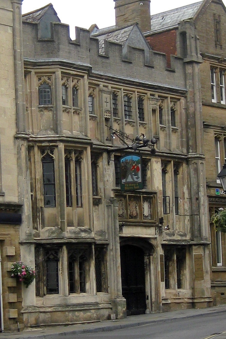
George Hotel and Pilgrims' Inn, Glastonbury

The George Hotel and Pilgrims' Inn in Glastonbury, Somerset, England, was built in the late 15th century to accommodate visitors to Glastonbury Abbey....
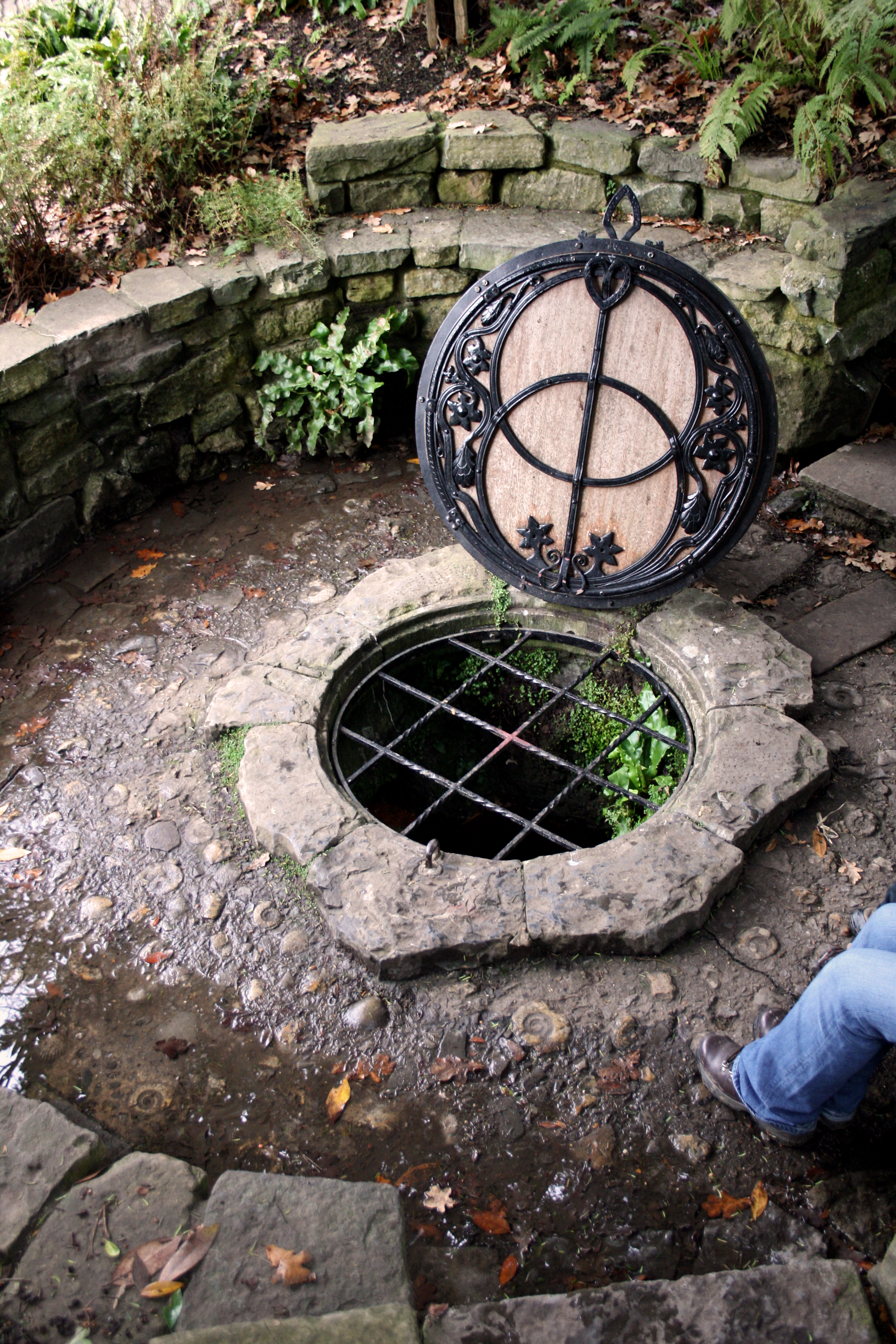
Chalice Well

The Chalice Well, also known as the Red Spring, is a well situated near the summit of Chalice Hill, a small hill next to Glastonbury Tor in Glastonbury...

Glastonbury

Glastonbury ( GLAST-ən-bər-ee, UK also GLAHST-) is a town and civil parish in Somerset, England, situated at a dry point on the low-lying Somerset Levels...

Somerset Rural Life Museum

The Somerset Rural Life Museum is situated in Glastonbury, Somerset, UK. It is a museum of the social and agricultural history of Somerset, housed in buildings...

Beckery

Beckery (also Little Ireland) is an area within Glastonbury. It was once the main industrial area of the town. The area is said to have been visited by...

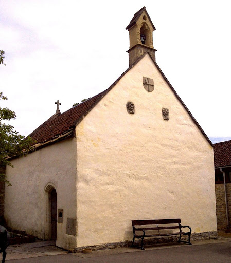
St. Patrick's Chapel, Glastonbury

St. Patrick's Chapel in Glastonbury, Somerset, England, is housed within the grounds of Glastonbury Abbey, and was completed in 1517. It is a site of pilgrimage...

Glastonbury Abbey

Glastonbury Abbey was a monastery in Glastonbury, Somerset, England. Its ruins, a grade I listed building and scheduled ancient monument, are open as a...

Roman Catholic Diocese of Glastonbury

Roman Catholic Diocese of Glastonbury is a former bishopric and present Latin titular (arch)bishopric in England. == History == Glostonbury was the name...

Nearby Amenities

Located within 500m of 51.148226,-2.7060655
Post Box
Brand: Royal Mail
Brand Wikidata: Q638098
Brand Wikipedia: en:Royal Mail
Operator: Royal Mail
Operator Wikidata: Q638098
Lat/Long: 51.1511059/-2.7066287
Place Of Worship
Lat/Long: 51.1476269/-2.7123952
Place Of Worship
Gospel Hall
Religion: christian
Lat/Long: 51.148421/-2.7119875
School
Lat/Long: 51.1490941/-2.7114446
Post Box
Brand: Royal Mail
Brand Wikidata: Q638098
Brand Wikipedia: en:Royal Mail
Collection Times: Mo-Fr 09:00; Sa 07:00
Operator: Royal Mail
Operator Wikidata: Q638098
Post Box Type: pillar
Ref: BA6 112D
Royal Cypher: EIIR
Royal Cypher Wikidata: Q33102113
Source: survey
Lat/Long: 51.1446739/-2.7103355
Barrier: kissing_gate
Lat/Long: 51.1467786/-2.7022505
Barrier: kissing_gate
Lat/Long: 51.1464547/-2.7010569
Barrier: kissing_gate
Lat/Long: 51.1465524/-2.7036528
Bench
Backrest: yes
Lat/Long: 51.1498187/-2.7039178
Bench
Backrest: yes
Seats: 3
Lat/Long: 51.1468407/-2.6993418
Chalice Well
Drinking Water: yes
Name Ja: チャリス・ウェル
Natural: spring
Note: Also known as the Red Spring.
Lat/Long: 51.1437803/-2.7060151
Bus Stop
The Queen's Head
Bench: yes
Bin: yes
Bus: yes
Naptan AtcoCode: 3600SOB20965
Naptan Bearing: W
Naptan CommonName: The Queen's Head
Naptan Indicator: W-bound
Naptan NaptanCode: sotawtdw
Naptan Street: High Street
Naptan Verified: no
Public Transport: platform
Shelter: yes
Tactile Paving: yes
Lat/Long: 51.1481847/-2.7126896
Bus Stop
The Queen's Head
Bench: yes
Bin: yes
Bus: yes
Naptan AtcoCode: 3600SOB20964
Naptan Bearing: E
Naptan CommonName: The Queen's Head
Naptan Indicator: E-bound
Naptan NaptanCode: sotawtga
Naptan Street: High Street
Naptan Verified: no
Public Transport: platform
Shelter: yes
Tactile Paving: yes
Lat/Long: 51.1482785/-2.7126916
The Foot Health Clinic
Addr City: Glastonbury
Addr Street: High Street
Healthcare: podiatrist
Lat/Long: 51.1480613/-2.7129966
Back 2 Back
Addr City: Glastonbury
Addr Street: High Street
Contact Facebook: https://www.facebook.com/people/Hair-at-Back2Back/100063614978245/
Shop: hairdresser
Lat/Long: 51.1482764/-2.7128807
Addr City: Glastonbury
Addr Street: High Street
Building: house
Lat/Long: 51.1482566/-2.7129652
Vintrotique
Addr City: Glastonbury
Addr Street: High Street
Shop: gift
Lat/Long: 51.1482482/-2.7130363
Emajon
Addr City: Glastonbury
Addr Street: High Street
Shop: yes
Lat/Long: 51.1482301/-2.7131309
Addr City: Glastonbury
Addr Street: High Street
Building: house
Lat/Long: 51.1482036/-2.7132274
White Spring
Drinking Water: yes
Natural: spring
Lat/Long: 51.1438833/-2.7054231
Generator Method: photovoltaic
Generator Output Electricity: yes
Generator Source: solar
Generator Type: solar_photovoltaic_panel
Location: roof
Power: generator
Lat/Long: 51.1490066/-2.7109838
Generator Method: photovoltaic
Generator Output Electricity: yes
Generator Source: solar
Generator Type: solar_photovoltaic_panel
Location: roof
Power: generator
Lat/Long: 51.1490655/-2.7113324
Generator Method: photovoltaic
Generator Output Electricity: yes
Generator Source: solar
Generator Type: solar_photovoltaic_panel
Location: roof
Power: generator
Lat/Long: 51.1486836/-2.7120298
Generator Method: photovoltaic
Generator Output Electricity: yes
Generator Source: solar
Generator Type: solar_photovoltaic_panel
Location: roof
Power: generator
Lat/Long: 51.148697/-2.711944
Generator Method: photovoltaic
Generator Output Electricity: yes
Generator Source: solar
Generator Type: solar_photovoltaic_panel
Location: roof
Power: generator
Lat/Long: 51.1488636/-2.7121291
Generator Method: photovoltaic
Generator Output Electricity: yes
Generator Source: solar
Generator Type: solar_photovoltaic_panel
Location: roof
Power: generator
Lat/Long: 51.1486819/-2.7106941
Generator Method: photovoltaic
Generator Output Electricity: yes
Generator Source: solar
Generator Type: solar_photovoltaic_panel
Location: roof
Power: generator
Lat/Long: 51.1493263/-2.7115551
Generator Method: photovoltaic
Generator Output Electricity: yes
Generator Source: solar
Generator Type: solar_photovoltaic_panel
Location: roof
Power: generator
Lat/Long: 51.1498597/-2.7093262
Generator Method: photovoltaic
Generator Output Electricity: yes
Generator Source: solar
Generator Type: solar_photovoltaic_panel
Location: roof
Power: generator
Lat/Long: 51.1499051/-2.7095434
Generator Method: photovoltaic
Generator Output Electricity: yes
Generator Source: solar
Generator Type: solar_photovoltaic_panel
Location: roof
Power: generator
Lat/Long: 51.1496847/-2.7101657
Generator Method: photovoltaic
Generator Output Electricity: yes
Generator Source: solar
Generator Type: solar_photovoltaic_panel
Location: roof
Power: generator
Lat/Long: 51.1492472/-2.7086261
Generator Method: photovoltaic
Generator Output Electricity: yes
Generator Source: solar
Generator Type: solar_photovoltaic_panel
Location: roof
Power: generator
Lat/Long: 51.1492186/-2.7085724
Generator Method: photovoltaic
Generator Output Electricity: yes
Generator Source: solar
Generator Type: solar_photovoltaic_panel
Location: roof
Power: generator
Lat/Long: 51.1498529/-2.7060056
Generator Method: photovoltaic
Generator Output Electricity: yes
Generator Source: solar
Generator Type: solar_photovoltaic_panel
Location: roof
Power: generator
Lat/Long: 51.150849/-2.708889
Generator Method: photovoltaic
Generator Output Electricity: yes
Generator Source: solar
Generator Type: solar_photovoltaic_panel
Location: roof
Power: generator
Lat/Long: 51.1508557/-2.7089587
Generator Method: photovoltaic
Generator Output Electricity: yes
Generator Source: solar
Generator Type: solar_photovoltaic_panel
Location: roof
Power: generator
Lat/Long: 51.1501962/-2.7092215
Generator Method: photovoltaic
Generator Output Electricity: yes
Generator Source: solar
Generator Type: solar_photovoltaic_panel
Location: roof
Power: generator
Lat/Long: 51.1506589/-2.7094629
Generator Method: photovoltaic
Generator Output Electricity: yes
Generator Source: solar
Generator Type: solar_photovoltaic_panel
Location: roof
Power: generator
Lat/Long: 51.1506656/-2.7094898
Generator Method: photovoltaic
Generator Output Electricity: yes
Generator Source: solar
Generator Type: solar_photovoltaic_panel
Location: roof
Power: generator
Lat/Long: 51.1514176/-2.7109462
Generator Method: photovoltaic
Generator Output Electricity: yes
Generator Source: solar
Generator Type: solar_photovoltaic_panel
Location: roof
Power: generator
Lat/Long: 51.1513756/-2.7106297
Generator Method: photovoltaic
Generator Output Electricity: yes
Generator Source: solar
Generator Type: solar_photovoltaic_panel
Location: roof
Power: generator
Lat/Long: 51.1516111/-2.7101415
Generator Method: photovoltaic
Generator Output Electricity: yes
Generator Source: solar
Generator Type: solar_photovoltaic_panel
Location: roof
Power: generator
Lat/Long: 51.1514412/-2.7060485
Generator Method: photovoltaic
Generator Output Electricity: yes
Generator Source: solar
Generator Type: solar_photovoltaic_panel
Location: roof
Power: generator
Lat/Long: 51.1519476/-2.7061692
Generator Method: photovoltaic
Generator Output Electricity: yes
Generator Source: solar
Generator Type: solar_photovoltaic_panel
Location: roof
Power: generator
Lat/Long: 51.152025/-2.7061477
Generator Method: photovoltaic
Generator Output Electricity: yes
Generator Source: solar
Generator Type: solar_photovoltaic_panel
Location: roof
Power: generator
Lat/Long: 51.1520166/-2.7061075
Post Box
Collection Times: Mo-Fr 09:00; Sa 07:00
Operator: Royal Mail
Operator Wikidata: Q638098
Post Box Type: wall
Ref: BA6 114D
Royal Cypher: EIIR
Lat/Long: 51.14818/-2.7122554
Generator Method: photovoltaic
Generator Output Electricity: yes
Generator Source: solar
Generator Type: solar_photovoltaic_panel
Location: roof
Power: generator
Lat/Long: 51.1470885/-2.7101818
Generator Method: photovoltaic
Generator Output Electricity: yes
Generator Source: solar
Generator Type: solar_photovoltaic_panel
Location: roof
Power: generator
Lat/Long: 51.146932/-2.7111554
Generator Method: photovoltaic
Generator Output Electricity: yes
Generator Source: solar
Generator Type: solar_photovoltaic_panel
Location: roof
Power: generator
Lat/Long: 51.1456911/-2.7032214
Generator Method: photovoltaic
Generator Output Electricity: yes
Generator Source: solar
Generator Type: solar_photovoltaic_panel
Location: roof
Power: generator
Lat/Long: 51.1457146/-2.7031678
Generator Method: photovoltaic
Generator Output Electricity: yes
Generator Source: solar
Generator Type: solar_photovoltaic_panel
Location: roof
Power: generator
Lat/Long: 51.145495/-2.7038384
Generator Method: photovoltaic
Generator Output Electricity: yes
Generator Source: solar
Generator Type: solar_photovoltaic_panel
Location: roof
Power: generator
Lat/Long: 51.1442095/-2.7092376
The Washing Well
Shop: laundry
Lat/Long: 51.1483097/-2.7127601
Razor King Barbershop
Shop: hairdresser
Lat/Long: 51.1480501/-2.7130699
Figaro de Montmartre
Shop: esoteric
Lat/Long: 51.1481382/-2.7125783
Shop: vacant
Lat/Long: 51.1481552/-2.7124452
Chocolate Love Temple
Shop: chocolate
Lat/Long: 51.1481187/-2.7127327
Mumani Vintage
Shop: clothes
Lat/Long: 51.1481248/-2.7126778
Heritage Estates
Office: estate_agent
Lat/Long: 51.1480439/-2.7131874
The Wonky Broomstick
Disused Amenity: pub
Shop: esoteric
Lat/Long: 51.1481037/-2.7128271
Secret World Wildlife Rescue
Shop: charity
Lat/Long: 51.1480288/-2.7128241
The data included in this document is from www.openstreetmap.org. The data is made available under ODbL.

Have you been to Bushy Combe?

Leave your review of Bushy Combe below (or comments, questions and feedback).